
Bill and Hillary Clinton National Airport/Adams Field (LIT)
Bill and Hillary Clinton National Airport/Adams Field (LIT) is a multi-use airport located on the eastern edge of the city of Little Rock, Arkansas, and just south of the Arkansas River. The traffic mix consists of almost every aspect of aviation, from air carrier to business, general aviation, and military. FBOs and general aviation services are located on the western side of the airfield and between the RWYs. View a printable Pilot Handbook of the LIT information found on this Web page.
Know Before You Go
LIT Tower Hours of Operation: 24 Hours
Administrative Office: Open 0730L-1600L M-F
Business Phone: 501-379-2902
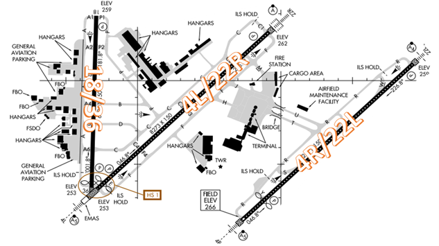
The airport configuration consists of parallel RWYs 4L/R and 22L/R along with RWY 18/36.
IMPORTANT: Check NOTAMS for RWY and TWY closures.
The airspace at LIT is Class C.
Below find various LIT-specific information and things to be aware of, as well as general information to inform your preflight planning. This will be reviewed quarterly and updated as needed. This information is to supplement the From the Flight Deck Videos that are produced by the FAA Runway Safety Group. Here you will also find information provided by the local air traffic controllers at the airport where you intend to fly. The information is subject to change. Not for navigation or legal* pre-flight action. Always refer to official pre-flight materials such as, but not limited to, NOTAMs, airport diagrams, VFR charts and airport construction notices for the latest airport-specific details.
Hot Spots
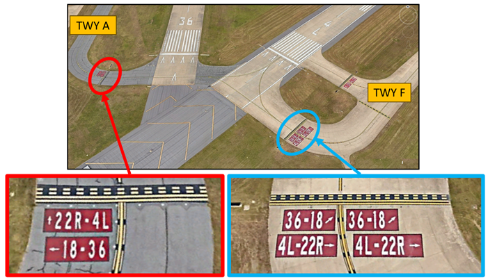
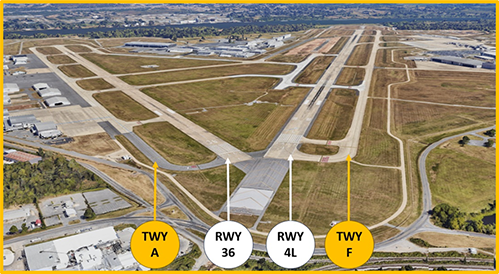
- HS 1 Wrong Runway Departure Risk – RWY 36 and RWY 04L thresholds in close proximity and share single hold lines at both TWY A and TWY F. Ensure correct RWY alignment.
- When LIT is in a north configuration, aircraft taxied to either RWY 4L or RWY 36 may be crossed to the other RWY for departure.
- If you cannot accept the other RWY or want a specific RWY for departure, advise Ground Control on initial taxi request.
- Make sure your aircraft is aligned with the correct RWY, as there is no hold short line between RWY 4L and RWY 36.
- Verify proper heading prior to starting takeoff roll. When lining up on either RWY, check the RWY designator (If able) to make sure you are on the correct RWY.
- The RWY 4L threshold is displaced 297’ and the RWY 36 threshold is displaced 164’. The portion of runway behind a displaced threshold is available for takeoffs in either direction and landings from the opposite direction.
- The yellow chevrons preceding both RWYs are used to show pavement areas aligned with the RWYs that are unusable for landing, takeoff, and taxiing.
- If you are unsure of your clearance or position, ask the TWR.
- Review NOTAMS for the Letter to Airmen: LTA-LIT-14 on “RWY 36 and 4L Taxi Instructions.”
Wrong Surface RWY Landing Risk
- Pilots on left downwind for RWY 36 or right downwind for RWY 4L have attempted to land on the wrong RWY.
- Expectation bias or just lining up on the first RWY pilots see can lead to wrong surface landings.
- Verify that the heading on final aligns with the assigned landing RWY.
- If available, back up all visual approaches with an instrument approach to help ensure that you are lined up for the correct surface.
Wrong Airport Landing Risk
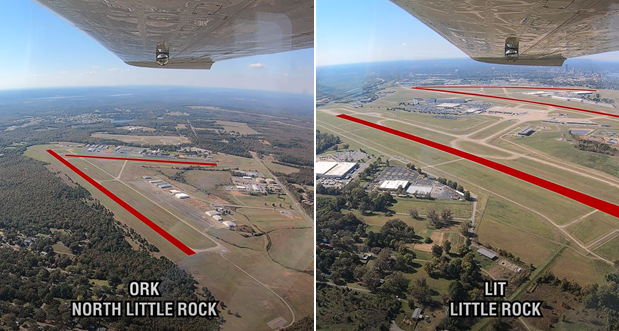
- Approximately six miles north-northwest of LIT is North Little Rock Municipal Airport (ORK).
- RWY configuration is similar. Pilots inbound to LIT from the north and northwest have attempted to land here.
- Use the most precise navigational aids available such as GPS, localizers, or VOR radials to positively identify the airport.
- If you're talking to ATC and you're unsure, ask the controller.
- From the Flight Deck – Wrong Airport Landings video available here.
Surface Risk - Movement Area Cautions
- TWY A is connected to the West Ramp by a large unbroken expanse of concrete with no distinguishable exit/entry points other than TWY centerline markings.
- Pilots exiting the West Ramp have failed to turn onto TWY A and taxied onto RWY 18/36 without clearance.
- There are five connector TWYs (A6, A5, A4, A3, A2) that provide access to RWY 18/36 from TWY A in this area. The connector TWYs have Hold Short Position markings and signs that clearly identify the RWY.
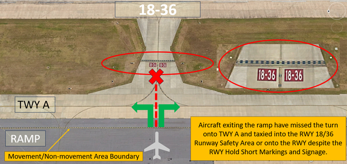
- A thorough understanding of taxi clearance including route, turns, and hold short instructions prior to beginning taxi will help avoid a runway incursion.
General
- LIT Class C is heavily congested airspace.
- Taxilanes A2/A3 have unidirectional centerline lights.
- There is no airport sponsored transient parking at LIT. Transient parking may be available at the FBOs near the fuel pit. Contact the FBO in advance for availability and reservations.
- Large concentrations of birds in the vicinity of the airport with most activity between sunrise and sunset and up to 1500´ MSL.
Traffic Patterns
- Controllers may switch aircraft to different runways or left/right traffic pattern to accommodate other departures/arrivals.
Ground Control
- The terminal ramp is uncontrolled, and Ground Control does not require pushback clearance.
- Please advise of current location when requesting to taxi.
Runway Crossings
- Read back all hold short instructions with your callsign in the same transmission.
Takeoff/Departure
- All VFR departures require a VFR clearance. Please contact Clearance Delivery for VFR clearance before requesting taxi. In your request, please state full callsign, type of aircraft, and destination. You may omit the destination with on course heading if you just want VFR services to the edge of the Class C Basic Radar Service Area.
- If you want VFR flight following to your destination, please advise Clearance Delivery during your VFR clearance request. The subsequent flight plan will be forwarded to Memphis Center and assigned a National Airspace System (NAS) squawk code.
Arrival/Landing
- Little Rock Approach Control will sequence all VFR/IFR arrivals into LIT.
- Please advise Approach if your intent is to do VFR traffic pattern work or full stop taxi back at LIT.
- If your intent is to return to Approach Control after one option/touch and go/low approach, advise Approach Control so they can issue climb-out instructions
- TWR may change your sequence depending on VFR pattern traffic.
- Review NOTAMS for the Letter to Airmen: LTA-LIT-17 on “Practice Instrument Approaches for VFR Aircraft”.
Special Traffic (Military / Commercial / Helicopter, etc.)
- The largest C-130 training base is located at Little Rock Air Force Base (LRF) approximately 12 miles north. It is common for C-130s to be in the VFR pattern at LIT.
- The Little Rock Metro Area has many hospital helipads near LIT. Maintain alertness for MEDEVAC helicopters transitioning through the area.
Additional Information
- The voluntary noise abatement procedures at LIT are informal and not mandatory per the 14 CFR Part 150 "2004 Little Rock Noise Compatibility Program".
- The informal "land left, depart right" procedures for jet aircraft may be followed to the extent practical.