
General Mitchell International Airport (MKE)
General Mitchell International Airport (MKE) is a primarily commercial airport that is situated just west of Lake Michigan and five miles south of downtown Milwaukee, Wisconsin. The airport is home to the General Mitchell Air National Guard Base on the eastern side of the airport. A complex system of TWYs provides access to all services on the airfield. MKE serves the full range of aircraft from single-engine general aviation to heavy KC-135R tankers. View a printable Pilot Handbook of the MKE information found on this Web page.
Know Before You Go
MKE Tower: Hours of Operation – 24/7
Administrative Office: Open 0700L to 1530L M-F
Business Phone: 414-489-2150
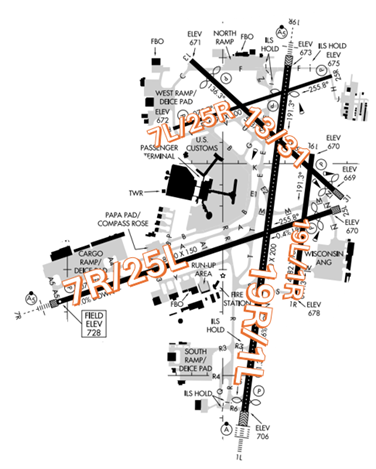
The airport configuration consists of two sets of parallel runways designated RWYs 1/19 L/R and 7/25 L/R along with RWY 13/31.
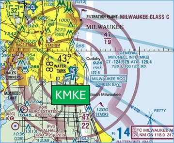
The airspace at MKE is Class C. (Refer to Sectional Chart)
Wrong Surface Landing Risk
- Parallel RWYs with staggered thresholds present the risk of landing on the wrong RWY.
- Whenever a TWY runs parallel to a RWY, the risk of landing on a TWY increases.
- If available, back up all visual approaches with an instrument approach/GPS Waypoint to help ensure that you are lined up for the correct surface.
- View the From the Flight Deck - Wrong Surface Landings video for additional mitigation strategies.
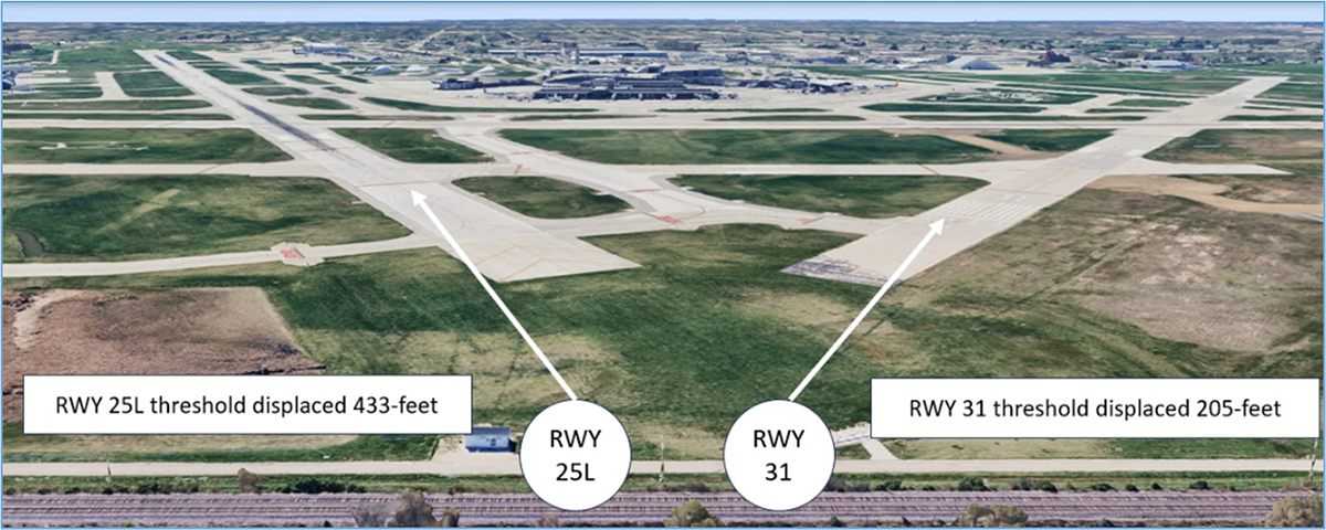
- A Wrong Surface Landing risk also exists due to the proximity of the approach ends of RWY 25L and RWY 31.
- Both RWYs are similar in appearance with displaced thresholds and overruns.
- Expectation bias or lining up on the first RWY that pilots see can lead to wrong surface landings.
- Pilots should verify that the heading on final aligns with the assigned landing RWY.
- Loading an instrument approach/GPS Waypoint to the assigned RWY will help pilots ensure they are lined up for the proper surface.
Surface Risk - Movement Area Cautions
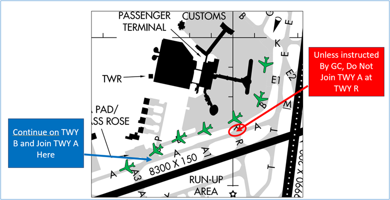
- When issued taxi instructions via TWYs B and A, continue on TWY B until it joins TWY A near TWY P. Pilots should not use TWY R to join TWY A unless instructed to do so.
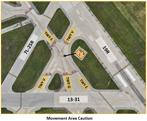
- The intersection of TWY E and TWY V is a large expanse of concrete bound on all sides by RWYs. TWY E splits off to TWY G. RWY hold short markings, above ground signage, and surface painted markings are all present to assist pilots in navigating this location.
General
- Airport Surface Detection Equipment (ASDE-X) in use. Operate transponders with altitude reporting mode and ADS-B (if equipped) enabled on all airport surfaces.
- Most of the traffic is air carrier and air taxi.
- RWY 7L/25R is closed to all jet aircraft.
Traffic Patterns
- The calm wind RWY configuration is departing RWY 19R while landing RWY 25L.
- For props when RWY 7R/25L is in use expect pattern work on RWY 7L/25R. When RWY 1L/19R is in use expect pattern work on RWY 1R/19L.
- Jets may only use RWYs 1L/19R, 7R/25L and 13/31 due to noise abatement.
Ground Control (GC)
- When approaching the departure end of the RWY, do not switch to TWR frequency without being directed by Ground Control (GC). It is common for your takeoff sequence to change.
- Advise GC if you need a run-up.
Runway Crossings
- A clearance to cross two RWYs may be given by GC in several locations across the airfield.
- Pilots should read back all instructions including their call sign in the transmission.
Takeoff/Departure
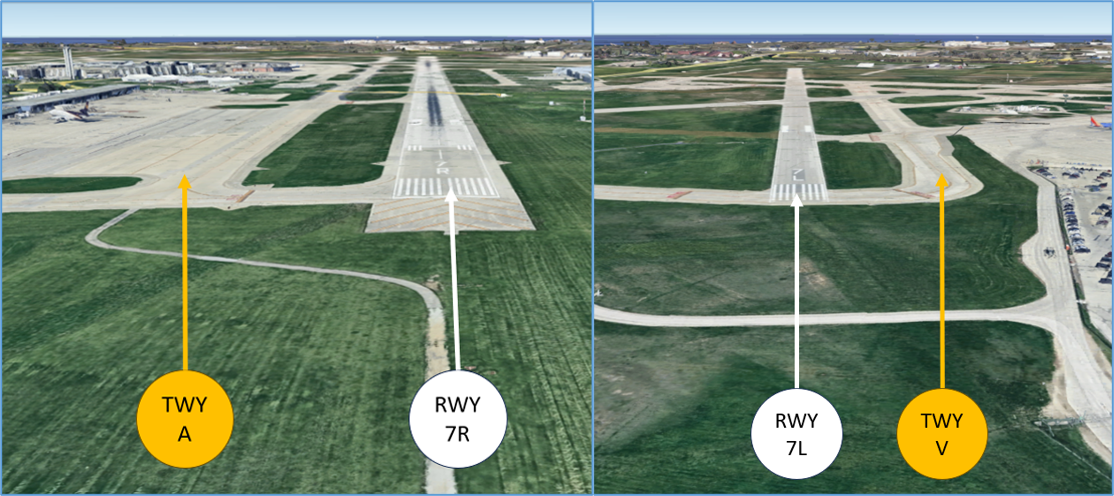
- The only intersection departure available for jet aircraft is RWY 19R at TWY V. Aircraft must be established on TWY V to use this intersection.
- Non-turbine aircraft should advise GC if they would like an intersection departure when calling for taxi.
Arrival/Landing
- When landing RWY 25L/R or RWY 7L/R advise where you are parking. There are two FBOs on the north side and one FBO on the south side of the airfield.
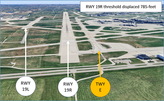
- When exiting RWY 1L at TWY E2, left turns onto TWY E southbound are not authorized.
Weather
- When snow removal is in progress, the airfield is typically closed. Aircraft may be allowed to taxi on a case-by-case basis depending on the snow removal operation.
- When Runway Visual Range (RVR) values are below 1200’, Surface Movement Guidance and Control System procedures are in effect.
- Being close to Lake Michigan can lead to strong easterly gusts off the lake regardless of the winds in the area. This can lead to a strong tailwind on final for RWY 7R followed by strong gusty head winds within a few miles of the RWY.
- When temperatures rapidly drop, it is common for fog or low ceilings to develop over the coast of Lake Michigan.
Military
- MKE is home to a squadron of Wisconsin Air National Guard KC-135R heavy tankers and occasionally supports other military aircraft such as F16s, F35s and T38s.
- American Family Field stadium is located just outside of the MKE Class C airspace and has military flyovers throughout the year.
Additional Information
- Helicopter tours of downtown Milwaukee take off and land at the west ramp.
- In the summer months, banner tow aircraft frequently fly over downtown Milwaukee.