
Monterey Regional Airport (MRY)
Monterey Regional Airport (MRY) is located 3.5 miles east of downtown Monterey, with access to numerous world-famous attractions in central California. In addition to a large transient general aviation operation, the traffic mix also includes local general aviation, air taxi, commercial, and military operations. View a printable Pilot Handbook of the MRY information found on this Web page.
Know Before You Go
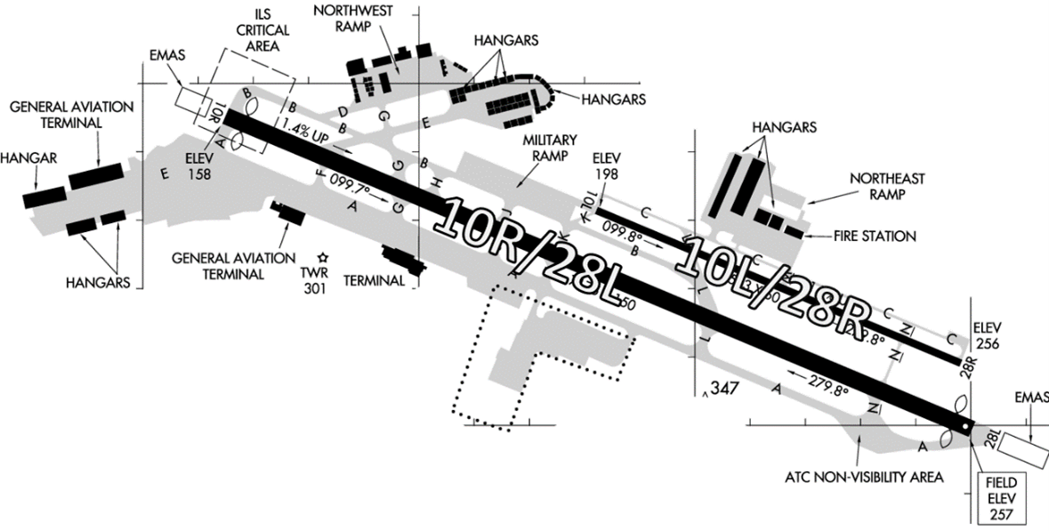
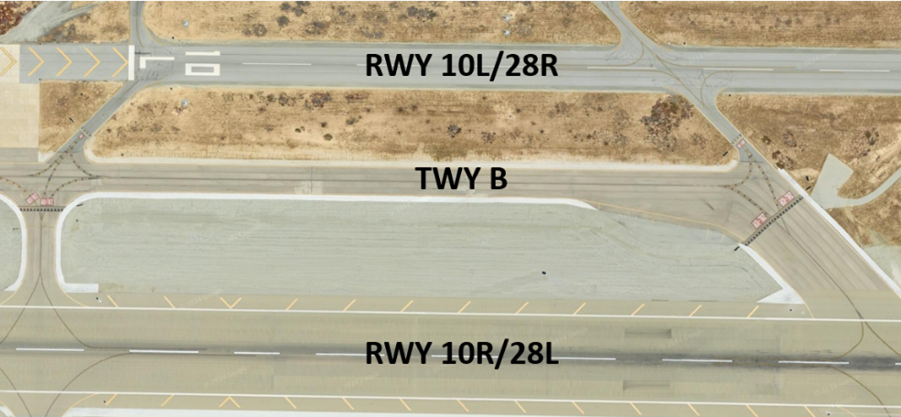
There are two parallel RWYs with staggered thresholds at the west end of the airport. The larger RWY 10R/28L is considerably wider and longer than RWY 10L/28R.
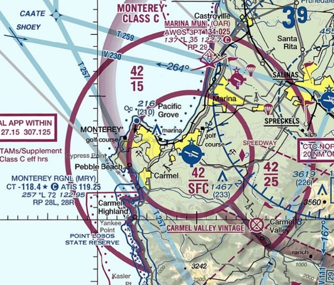
The airspace at KMRY is Class C. (See Sectional Chart.)
There is construction at the airport – Check NOTAMS.
TWR Open: 0600L – 2100L
Administrative Office Hours: 0600L to 1430L - M through F
Business Phone: 831-643-6819
Below find various MRY-specific information and things to be aware of, as well as general information to inform your preflight planning. This will be reviewed quarterly and updated as needed. This information is to supplement the From the Flight Deck Videos that are produced by the FAA Runway Safety Group. Here you will also find information provided by the local air traffic controllers at the airport where you intend to fly. The information is subject to change. Not for navigation or legal* pre-flight action. Always refer to official pre-flight materials such as, but not limited to, NOTAMs, airport diagrams, VFR charts and airport construction notices for the latest airport-specific details.
Hot Spots
- There are no published Hot Spots.
Wrong Direction Intersection Takeoff
- At any facility where intersection take-offs are possible, there is the risk that pilots will turn in the wrong direction.
- For all takeoffs:
- Always check the Magnetic Compass and the Horizontal Situation Indicator (HSI), (if installed), to verify that the nose of the airplane is pointed in the correct direction.
- Minimize all distractions before, during, and after turning onto the RWY.
- See From the Flight Deck – Wrong Direction Intersection Takeoffs.
Wrong Surface Landings
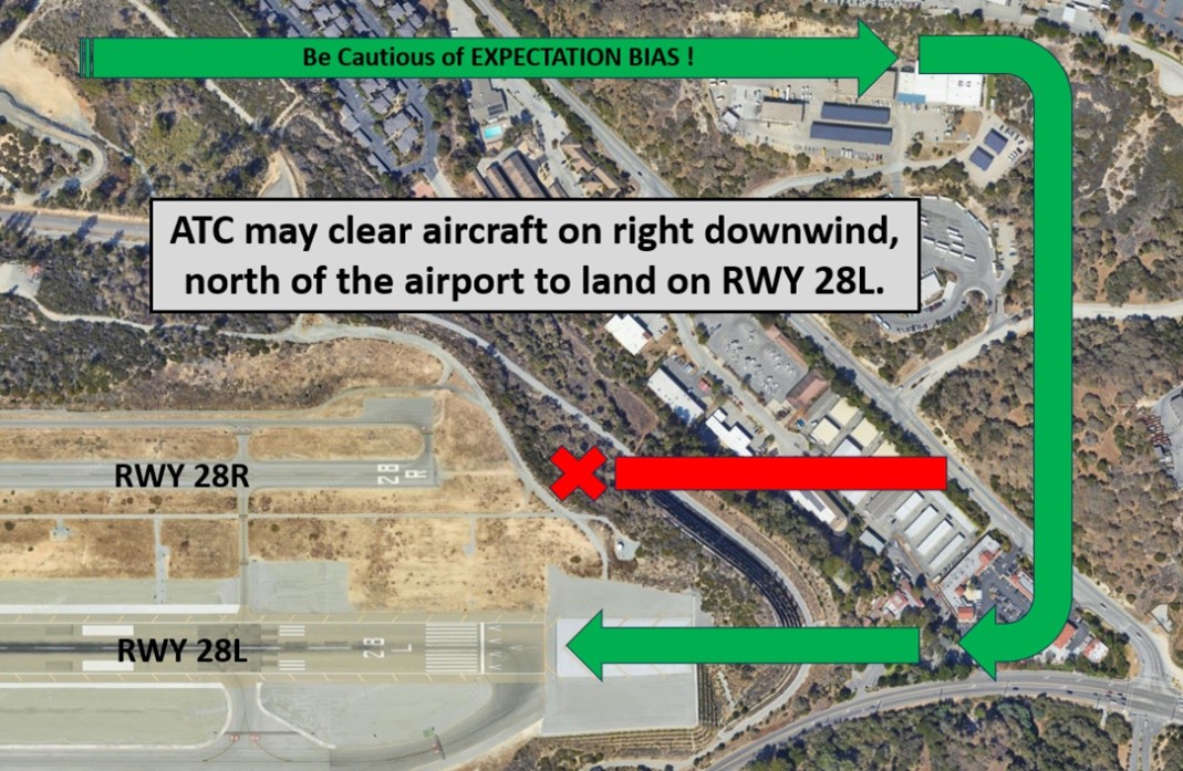
- TWR may clear aircraft on right downwind, north of the airport, to land on RWY 28L instead of RWY 28R.
Additional Information
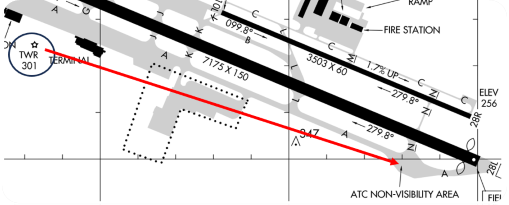
- The RWY 28L run-up area at the east end of TWY A is not visible from the TWR.
Clearance Delivery
- Clearance Delivery is normally combined with Ground Control frequency except during busy events.
Arrival/Landing
- RWY 28L PAPI are unusable within 1/2m final.
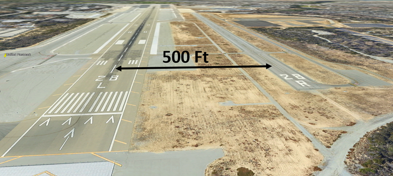
- RWY28L/28R centerlines are separated by 500 feet. Ensure aligned with the correct RWY assignment. (See Arrival Alert Notices.)
- Do not conduct the post landing checklist on TWY A. Be prepared to exit the RWY and taxi to parking immediately.
Movement Areas/Ground Operations
- TWY B between RWY 28L/R is often confused as RWY 28L and aircraft tend to hold short of TWY B and do not clear RWY 28R.
- Maintenance run ups are only able to be conducted in the 28L run up area.
Special Traffic (Military / Commercial / Helicopter, etc.)
- Parking at the Military Ramp requires prior coordination.
Additional Information
- MRY now has self service fuel at the North East Ramp.
- Engineered Material Arresting System (EMAS) located at ends of RWYs 10R and 28L.
- Displaced thresholds on RWYs 10R and 28L
Terrain
- High terrain to the east usually causes a Low Altitude Alert for RWY 28L IFR arrivals.
Special Events
- During times of busy events, single engine piston driven aircraft requesting to taxi to Del Monte Aviation/ Monterey Jet Center can expect to be parked at an alternate location.
NOTAMS
- Check NOTAMS for the following FAA Letters to Airmen:
- IFR Separation for VFR Aircraft Practicing Instrument Approaches
- Potential hazard in the vicinity of the Los Altos Gun Club Range