Dane County Regional Airport-Truax Field (MSN)
Dane County Regional Airport-Truax Field (MSN), is a large multi-use airport located on the north side of the city of Madison, Wisconsin. The airport serves air carriers, military, cargo, business, and general aviation. The pilot experience level goes from the basic new student all the way to seasoned air carrier or military pilot. The airport configuration consists of three intersecting runways and a complex system of taxiways. View a printable Pilot Handbook of the MSN information found on this Web page.
Know Before You Go
- MSN consists of 3 intersecting RWYs with intersections at two spots on each RWY.
- Businesses located on the east, west and south side of the airport.
- Due to the surrounding topography, aircraft arriving from the northeast and northwest have misidentified RWY 18 and RWY 21.
- Transiting the airport from RWY 18/36 to the east side facilities requires at least two runway crossings. This is especially true on TWY C.
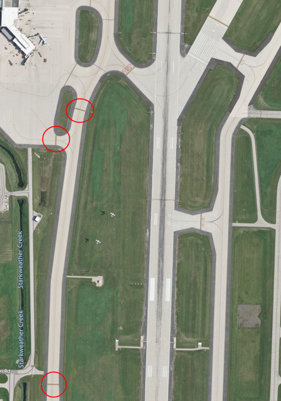
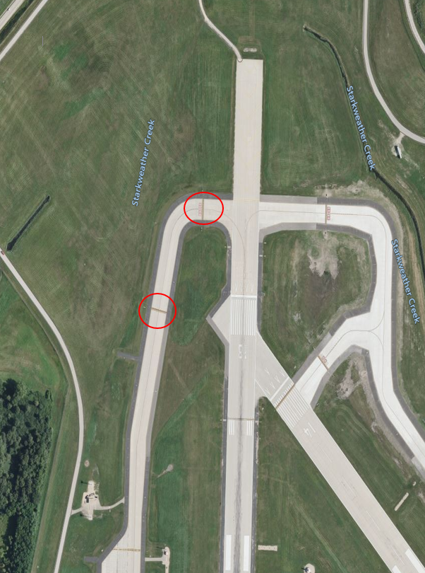
- HS 2 – numerous aircraft have missed the RWY Hold Short Line on TWY C.
- You need a specific clearance to cross any RWY, active or not.
- HS 1 – is a complex and possibly confusing intersection of 2 RWYs and a TWY.
Below find various MSN-specific information and things to be aware of, as well as general information to inform your preflight planning. This will be reviewed quarterly and updated as needed. This information is to supplement the From the Flight Deck Videos that are produced by the FAA Runway Safety Group. Here you will also find information provided by the local air traffic controllers at the airport where you intend to fly. The information is subject to change. Not for navigation or legal* pre-flight action. Always refer to official pre-flight materials such as, but not limited to, NOTAMs, airport diagrams, VFR charts and airport construction notices for the latest airport-specific details.
MSN Tower Administrative Office: 0700L to 1530L M-F
Business Phone: 608-244-5691
The airspace at MSN is Class C with a 4900’ MSL ceiling. (Refer to Sectional Chart)
Class C Airspace Requirements (CFR §91.130 and AIM 3-1-4; 3-2-4):
| Visibility | 3 statute miles |
| Distance from Clouds | 500 feet below | 1,000 ft above | 2,000 ft horizontal |
| Communications | Establish communications (controller response) |
| Pilot | No special certification required |
| Equipment | Two-way radio, operable radar transponder with altitude reporting and ADS-B Out |
Hot Spots
- HS 1: Closely aligned RWYS – RWY 36 and RWY 03 at TWY A4.
- HS 2: Pilots exiting RWY 18-36 on TWY C sometimes miss the hold short for RWY 03-21.
Departure
- Verify proper heading prior to starting takeoff roll on all intersection departures.
- RWY 14 and RWY 18 approach ends close aligned, verify correct RWY and compass heading prior to departure.
Landing
- Wrong surface landing risk
Surface Risk – Movement Area
- TWY F and TWY G restricted to fighter aircraft only.
- West Ramp restricted to air carrier aircraft only.
Additional Cautions
- Barricades along west edge of south ramp adjacent to military ramp.
- Check NOTAMS for the following:
- Airport construction scheduled to start on 02/19/2025.
- Air Traffic Control TWR Letter to Airmen.
MSN Tower (TWR) operates from 0600L-2300L.
When TWR is closed:
- The airspace becomes Class E
- Use CTAF 119.3
- Clearance Delivery, Chicago Center on 135.45 or 630-906-8921
- Closing Flight Plan, AFSS for VFR, for IFR Chicago Center on 135.45 or 630-906-8921
- Use CTAF to control Runway lighting when TWR is closed.
General
- Flying into MSN Airspace or into the airport can be a complex task. Our triple intersecting runways, numerous hotspots, and abundance of concrete can make this a complex airport to fly in and out of. The best thing a pilot can do is a well prepared preflight and flight planning. And most of all if you’re unsure of the instructions, ask and verify.
Traffic Patterns
- Normal traffic patterns for runways are left patterns.
- Sometimes we will instruct aircraft in the traffic pattern on RWY 32 to make right hand traffic patterns for better visibility of aircraft from the tower.
Ground
- Visibility of aircraft taxing on the east ramp from the control tower is difficult.
- The east ramp is uncontrolled.
- Be very specific relaying your location on the east ramp. Example: “we are on the north side of the east ramp, or we are in front of (specific hanger)”. Although we do not control the east ramp, this will allow us to better sequence you to the runway. Without this specificity, aircraft can easily “block” the approach end of RWY 32 resulting in possible delay for other aircraft.
- While performing “run-ups” or preparing for departure try and leave room for other aircraft to reach the end of RWY 32.
- When Madison is on South Flow we request that “run-ups” be completed on the east ramp.
- There are no run-up areas for RWY 21 or RWY 14 at the approach ends. If you complete the run-up at the runway and something happens, you can delay subsequent departures.
Runway Crossings
- When contacting Ground Control for taxi and/or holding short of a runway, be specific with your location. Example: “ground, N12345, holding short of RWY 32 at Charlie for the east ramp”.
Takeoff/Departure
- When contacting Tower for departure from an intersection, be sure to include the intersection designator. Example: “tower N12345 is holding short of RWY 32 at TWY echo, ready for departure”.
Arrival/Landing
- When requesting VFR services check in with, call sign, type aircraft, ATIS, position, altitude, and your request.
- When requesting an IFR flight plan, check in with call sign, ATIS, and altitude.
- When requesting approach landing Madison Airport call at least 15 miles from the airport. This will allow you to be sequenced more efficiently.
Avoidance Areas
- MSN is home to the Wisconsin Air National Guard Unit FW115th and the Army National guard helicopter base. Both are located on the southeast side of the airport. That area is restricted and when taxiing on taxiway bravo ensure that you do not turn onto taxiway foxtrot, or onto the ramp areas adjacent to taxiway bravo at bravo 5 or bravo 6.
Special Traffic (Military / Commercial / Helicopter, etc.)
- MSN is home to a wide variety of aircraft. The Wisconsin Air National Guard and the Army national guard are located on the southeast side of the airport housing F16’s (soon to be F35’s), and H60 helicopter, the west ramp is home to the air terminal for all commercial flights, and then the south and east ramps are home to our general aviation community, involving a flight school, charter flights, and aircraft owners.
RWY 14/18 and RWYs 03 and 36 are close alignment at the approach ends. Use Caution and ensure you are aligning to the right runway.
Use caution for the approach areas for RWYs 14 and 03. You may be asked to hold short of these areas when the runway is in use.
RWY 14 Approach Area
RWY 03 Approach Area