
Lakefront Airport (NEW)
Lakefront Airport (NEW), is a medium-sized airport, located on the east end of the city of New Orleans, Louisiana. Louis Armstrong New Orleans International Airport (MSY) is approximately 12 miles to the west. Its proximity to Lake Pontchartrain and airfield drainage factors makes the airport susceptible to operational interruptions during periods of heavy rain, primarily on RWY 18R. The field elevation is 7’ MSL, and there are surfaces on the airport that are less than that. View a printable Pilot Handbook of the NEW information found on this Web page.
Know Before You Go
NEW Tower 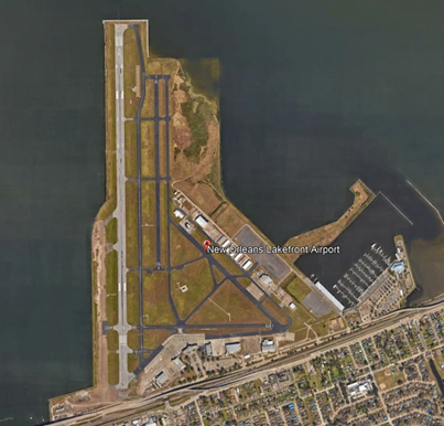
Hours of Operation: 0700L-2100L
Administrative Office: Open 0800L to 1600L - M through F
Business Phone: 504-240-7101
Traffic consists of general, air-taxi, military, and business aviation. There are also 2 flight schools making for a wide range of pilot experience and aircraft performance at NEW.
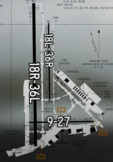
RWY configuration consists of two parallel RWYs with staggered thresholds designated RWY 18L/36R and 18R/36L. A third RWY designated RWY 9/27 intersects the larger RY 18R/36L.
The TWY system includes full-length parallel TWYs in between and alongside the parallel RWYs and provides access to businesses and services located on the east and south sides of the airport.
The airspace at NEW is Class D. It underlies New Orleans Class B airspace. (See Sectional Chart.)
Below find various NEW-specific information and things to be aware of, as well as general information to inform your preflight planning. This will be reviewed quarterly and updated as needed. This information is to supplement the From the Flight Deck Videos that are produced by the FAA Runway Safety Group. Here you will also find information provided by the local air traffic controllers at the airport where you intend to fly. The information is subject to change. Not for navigation or legal* pre-flight action. Always refer to official pre-flight materials such as, but not limited to, NOTAMs, airport diagrams, VFR charts and airport construction notices for the latest airport-specific details.
Hot Spots
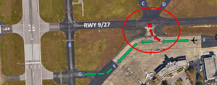
- HS 1: RWY Incursion Risk at TWY F and RWY 9/27 – Wide Intersection.
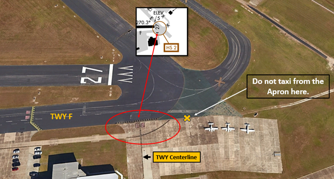
- HS 2: RWY Incursion Risk at TWY F and RWY 27– Hold Line is at Apron exit on TWY F.
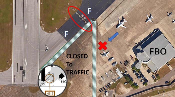
- HS 3: RWY Incursion Risk at TWY B and RWY 36L– Apron exit east of RWY 36L is inside Hold Lines.
Wrong Surface Intersection Takeoff
- The risk exists for a wrong direction takeoff during an intersection departure.
- Prior to entering the RWY and again when lining up on the RWY, check your Magnetic Compass and, your Horizontal Situation Indicator (HSI), if installed, to verify that you are pointed in the correct direction.
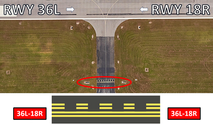
In the above example,
For a RWY 36L Intersection Takeoff you turn RIGHT.
For a RWY 18R Intersection Takeoff you turn LEFT.
Landing
After landing on the larger RWY 18R/36L, aircraft clearing to the east and instructed to taxi via TWY B have missed the turn and continued across RWY 18L/36R. 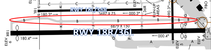
Wrong Surface (RWY and TWY) Landings
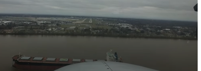
- Parallel RWYs with staggered thresholds present the risk of landing on the wrong RWY.
- Whenever a TWY runs parallel to a RWY, the risk of a TWY landing increases.
- If available, back up all visual approaches with an instrument approach.
- When RWYs are staggered, remember that the first RWY that becomes visible may not be your assigned RWY.

Surface Risk – Movement Area Cautions
- Hot Spot 1 (below) is located at the intersection of TWY's F/C/D, and RWY 9/27. It concerns aircraft cleared to taxi via TWYs, F, G then B. Pilots have missed the slight left turn onto TWY F and made the slight right turn onto RWY 9/27 thinking it was TWY G.
- Hot Spot 2 (below) is located at the approach end of RWY 27. The issue is the distance between TWY F and RWY 9/27. The Hold Short Line for RWY 27 is located considerably west of the approach end of the RWY on TWY F.
- Hot Spot 3 (below) is found on TWY F at the approach end of RWY 36L. There is a large concrete area south of TWY F. On the airport diagram it is designated as a closed surface. Aircraft taxiing out from the FBO have attempted to taxi directly to the approach end of RWY 36L instead of joining TWY F at or east of TWY B, bypassing the Hold Short Line for RWY 36L and leading to a RWY incursion.
Additional Information
- Boats as high as 80´ pass within 400´ of RWY 9 threshold.
- Boat masts up to 80´ within 0.5 NM of approach end of RWY 27.
- RWY 18R/36L has some low spots near intersection of RWY 9/27 holding water.
- TWY A uneven pavement.
- Caution TWY F between terminal ramp and flight line, first ramp irregular surface.
- Airport wind-cone for ballpark ramp lights OTS permanently.
- Overnight parking on terminal ramp must be coordinated with FBO.
General
- NEW TWR phone number is 504-240-7103. Feel free to call if you have any questions about the airport prior to arriving or departing.
- RWY 9/27 is commonly used as a taxi route for aircraft.
- RWY 9/27 will be used at the request of a pilot, traffic and weather permitting.
- NEW has two FBOs.
Traffic Patterns
- Standard traffic pattern for north flow ops is left traffic for RWY 36L and right traffic for RWY 36R. Standard pattern for south flow ops is right traffic RWY 18R and left traffic RWY 18L. RWY 9/27 traffic pattern will vary depending on operations.
- NEW has two flight schools.
- There are constant light civil aircraft in closed traffic patterns.
Ground Control
- If unfamiliar with the airfield or unsure of taxi instructions, please advise ATC and we will issue progressive taxi instructions.
- The Hold Short line for RWY 27 on TWY F is approximately 400’ from the end of the RWY.
Runway Crossings
- Read back all RWY crossing and hold short instructions.
Takeoff/Departure
- All IFR aircraft expect RWY heading to 2,000’unless a turn is requested and coordinated for weather avoidance.
- VFR aircraft can expect on course unless told otherwise for traffic avoidance.
- Aircraft requesting flight following should make the request with ground control when you are ready to taxi.
- Aircraft looking to depart to the north but wanting to follow the shoreline east or west around the lake rather than directly over the lake, advise ATC prior to departing.
- IFR aircraft departing RWY 36L/36R can expect a departure frequency of 133.15.
- IFR aircraft departing RWY 18R/18L can expect a departure frequency of 123.85.
Arrival/Landing
- Aircraft exiting RWY 36L/18R expect a right or a left turn immediately onto TWY B. Do not cross TWY B and parallel RWY 18L/36R.
- Advise TWR on initial contact that you have the current ATIS code or current weather information.
Weather
- Caution for rapidly changing weather and winds due to proximity to Lake Pontchartrain.
Avoidance Areas
- Departures to the west will be instructed to remain outside of Class B airspace until switched to Departure Control. NEW TWR cannot clear aircraft through the Class B airspace.
- Aircraft requesting the VFR Shoreline transition can expect to transition through the VFR corridor of Class B airspace at 1,500’and will talk to New Orleans TWR on frequency 119.5.
- Use caution for three large lighted antennas about 6 nm southeast of KNEW. Height is approximately 1,100’ AGL.
Special Traffic (Military / Commercial / Helicopter, etc.)
- Helicopter pattern ops are regularly conducted on TWY E and TWY C inside the closed traffic pattern to RWY 36R/18L.
- Regular helicopter departures from the terminal, for over the city tours, depart into the wind and routinely return from the west side of the airfield.
Additional Information
- NEW installed amber flashing lights (wig-wag lights) at the Hold Short lines for RWY 36L. The lights are there to assist pilots in locating the hold short lines for RWY 36L as well as the intersection of RWY 9/27 at midfield where RWY 9/27 intersects TWY F. These are locations where aircraft regularly cross the Hold Short lines by mistake.
- NEW airport is a peninsula on lake Pontchartrain and has constant bird activity year-round. Use caution for birds.
- The ILS critical area Hold Short line for RWY 18R is on TWY B just north of TWY K.
- Mowing operations are very common and are permitted in the Runway Safety Area (RSA).
- NEW has undertaken strategies to help alleviate wrong surface operations. These include enhanced TWY markings, above ground signage, lights, and painting areas of concrete green to delineate between TWYs and closed surfaces.