
Eppley Airfield (OMA)
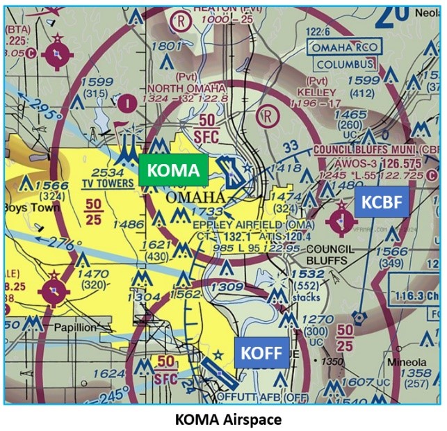
Eppley Airfield (OMA) is a medium sized, multi-use airport located on the northeast side of the city of Omaha, Nebraska. It is surrounded on all four sides by bodies of water. The Missouri River bounds the north, east, and south sides of the airport, with Carter Lake on the west. The location on the northeast edge of the city sometimes makes OMA difficult to find at night. Council Bluffs Airport (CBF) is located approximately five miles to the southeast and Offutt Air Force Base (OFF) is ten miles to the south. The OMA traffic mix is comprised of air carrier, air cargo, corporate and general aviation as well as some military flights. View a printable Pilot Handbook of the OMA information found on this Web page.
Know Before You Go
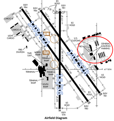
The airport configuration consists of parallel RWY’s 14L/32R and 14R/32L along with intersecting RWY 18/36. General Aviation services are located on the east side of the airfield.
The airspace at KOMA is Class C. (Refer to Sectional Chart)
OMA Tower Hours of Operation: Continuous
Administrative Office: Open 0730L to 1600L M-F
Business Phone: 402-271-7500
Below find various OMA-specific information and things to be aware of, as well as general information to inform your preflight planning. This will be reviewed quarterly and updated as needed. This information is to supplement the From the Flight Deck Videos that are produced by the FAA Runway Safety Group. Here you will also find information provided by the local air traffic controllers at the airport where you intend to fly. The information is subject to change. Not for navigation or legal* pre-flight action. Always refer to official pre-flight materials such as, but not limited to, NOTAMs, airport diagrams, VFR charts and airport construction notices for the latest airport-specific details.
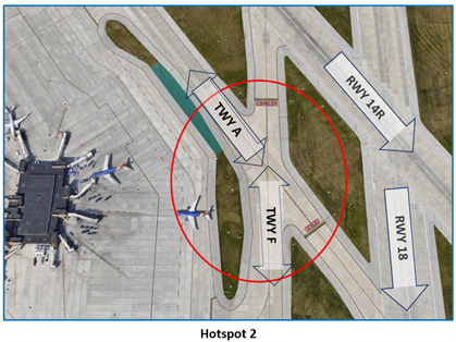
Hot Spots
HS 1: A complex intersection of TWY S and TWY F is located between RWY 14R/32L and the intersection of RWY 14L/32R and RY 18/36. 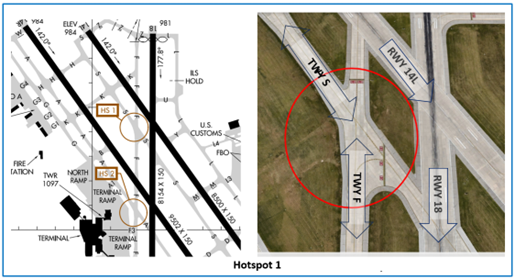
HS 2: Intersection of TWY A and TWY F is in close proximity to RWY 18/36 and RWY 14R/32L.
- The large expanse of concrete at both of these locations may be confusing and distracted pilots may cross the RWY Holding Position Markings.
- Both intersections have RWY hold short markings, above ground signage, and surface painted markings to assist pilots in navigating these locations.
- Pilots should review the taxi clearance before starting to taxi.
- Actively scanning to locate and identify RWY signs, markings, and lighting and deferring all heads down activities until holding short at the appropriate location will help eliminate these errors.
- If you are ever unsure about your clearance or position, ask the TWR.
Wrong Direction Intersection Takeoff Risk
- In the past, pilots have attempted wrong direction takeoffs during intersection departures.
- The most common intersection departures for GA aircraft at OMA are RWY 14L from TWY Y and RWY 18 from TWY U.
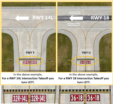
- Prior to entering the RWY and again when lining up on the RWY, check your Magnetic Compass and, your Horizontal Situation Indicator (HSI), if installed, to verify that you are pointed in the correct direction.
Wrong Surface Landing Risks
- Whenever a TWY runs parallel to a RWY, the risk of landing on a TWY increases.
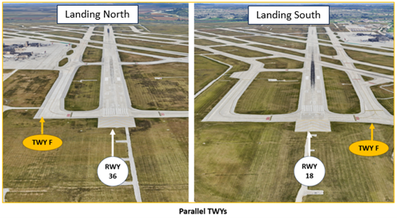
- Multiple full-length parallel TWYs are part of the OMA airfield geometry.
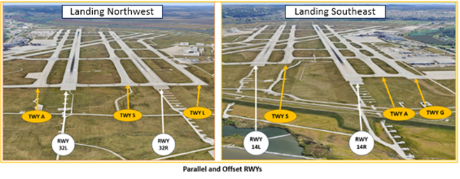
- Parallel RWYs with staggered thresholds present the risk of landing on the wrong RWY.
- When RWYs are staggered, remember that the first RWY that becomes visible may not be your assigned RWY.
- Runway Markings are White. Surfaces not used for Takeoff/Landing like Taxiway Markings, Chevrons, Runway Shoulder, and Runway Turn-on Markings, etc., are Yellow.
- When OMA is in a south configuration landing RWYs 14L/R and RWY 18, pilots approaching from the east and northeast that are cleared to land on RWY 14L/R have sometimes mistaken RWY 18 for their assigned RWY.
- Loading an instrument approach and verifying heading versus the RWY cleared will help pilots ensure that they are lined up for the correct RWY.
Additional Cautions
- When OMA is landing on RWYs 32L/R, pilots need to be aware of traffic arriving and departing CBF. The OMA Class C airspace is active from 2500’ to 5000’ over CBF.
- Pilots approaching OMA from the west/northwest, especially when the airport is landing RWYs 14L/R, need to be aware of several tall radio towers approximately five miles west of the airport. (Refer to Sectional Chart)
Clearance Delivery
- Clearance Delivery and Ground Control (GC) are frequently combined. This may result in multiple aircraft calling one controller that is working two frequencies.
- Pilots may hear a controller make a transmission without a response from the aircraft on the other frequency. Wait and listen for your call sign.
Ground Control
- Advise GC if you are requesting an intersection departure.
- Readback all hold short instructions to include RWY assignment with callsign.
Airfield Closures
- Year round, OMA experiences a higher-than-normal amount of TWY and RWY closures.
- Review NOTAMs carefully, listen closely to the ATIS, and pay close attention to ATC instructions as conditions frequently change while in flight.
Arrival/Landing
- After landing on either of the parallel RWYs, do not exit onto RWY 18/36 unless instructed to do so by TWR.
- If you are ever confused with your instructions or unsure of your position, ask the TWR.
- Omaha Approach Control handles ALL instrument practice approaches regardless of whether you are VFR or IFR.
- Review NOTAMS for the Letter to Airmen (LTA) for more information.
Winter Operations
- Snow and ice removal pose additional surface challenges at OMA.
- The airport uses alternating RWY procedures during snow events.
- Arrivals and departures should be prepared for either of the parallel RWYs.
- Additionally, there are numerous TWYs closed during snow removal.
- Pilots should listen closely to the ATIS, follow ATC instructions, and ask for assistance when needed.
Bird Activity
- OMA is surrounded by water on all four sides, resulting in a higher-than-normal number of migratory waterfowl in the vicinity. Be alert for the high probability of bird activity in the area.