
Snohomish County Airport (Paine Field) (PAE)
Seattle Paine Field International Airport (PAE) is a medium sized multi-use airport, located approximately 25 miles north of Seattle's Sea-Tac International Airport (SEA), and just east of the Puget Sound in Everett, WA. While it is primarily a general aviation airport, there is a large Boeing Aircraft manufacturing facility on the field. Test flights and taxi tests with large and heavy jet traffic are common. PAE has daily air carrier operations as well as several flight schools located on the airport. View a printable Pilot Handbook of the PAE information found on this Web page.
Know Before You Go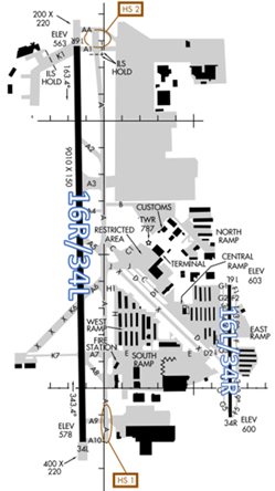
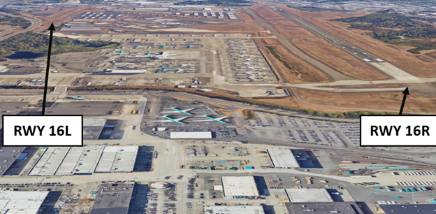
- The airport configuration consists of two parallel RWYs with staggered thresholds designated RWY 16L/34R and RWY 16R/34L.
- There is a full-length parallel TWY associated with both RWYs.
- TWY system provides access to all services, terminals, and businesses, primarily located between the RWYs.
The airspace at PAE is Class D and partially underlies Seattle Class B airspace. (Refer to Sectional Chart.)
PAE TWR
Hours of Operation – 0700L-2100L
Administrative Office
Open 0700L to 1500L - M through F (may vary)
Business Phone 425-923-1400
Below find various PAE-specific information and things to be aware of, as well as general information to inform your preflight planning. This will be reviewed quarterly and updated as needed. This information is to supplement the From the Flight Deck Videos that are produced by the FAA Runway Safety Group. Here you will also find information provided by the local air traffic controllers at the airport where you intend to fly. The information is subject to change. Not for navigation or legal* pre-flight action. Always refer to official pre-flight materials such as, but not limited to, NOTAMs, airport diagrams, VFR charts and airport construction notices for the latest airport-specific details.
Hot Spots
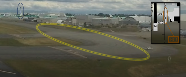
- HS 1 TWY A between TWY A9 and TWY A10 not visible from ATCT.
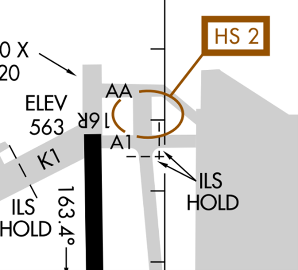
- HS 2 Enter RWY 16 full length via TWY A1 unless TWY AA specified by ATC.
Wrong Surface Intersection Takeoff
- Pilots lining up or turning in the wrong direction when cleared for an intersection takeoff is a recurring issue at PAE.
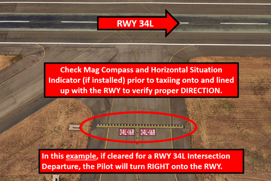
- Apply the above example to your situation. If taxiing from the opposite direction the RWY markings will have the numbers reversed.
Wrong Surface Taxiway Takeoff
When TWYS parallel RWYs, the potential exists for taking off on a TWY.
Wrong Surface Landing
- At airports with parallel RWYs, the potential exists for landing on the wrong RWY.
- RWY 16L/34R is half the size of the larger RWY 16R/34L.
- Staggered RWY thresholds at PAE increase the risk of mis-identifying and landing on the wrong RWY. See Arrival Alert Notices for more graphics and information.
Surface Risk – Movement Area Cautions
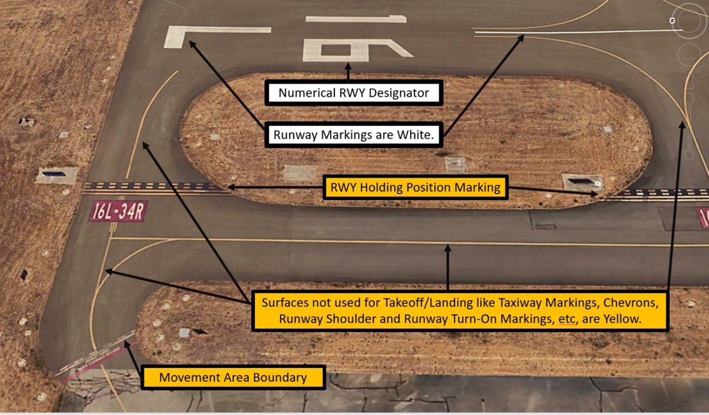
- Hot Spot 1 is located at the south end of TWY A between TWYs A9 and A10. This area is not visible from the TWR. Pilots are urged to provide precise position reports in this area when taxiing to RWY 34L .
Hot Spot 1 - Hot Spot 2 is located at the approach end of RWY 16R. TWY A1 is the normal route for aircraft taking off on RWY 16R.
- Pilots requiring TWY AA for the full length of RWY 16R must have TWR approval prior to taxiing north of TWY A1.
Hot Spot 2
Traffic Patterns
- Given the nature of mixed type aircraft operating at PAE, pattern entries to aircraft may be amended by ATC to better accommodate all users. This includes, but is not limited to, amending pattern entries, holding aircraft outside of Class Delta airspace, or changing runway assignment.
- RWY 16L/35R is closed when TWR is closed. Use CTAF 132.95.
Ground Control 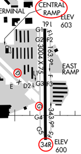
- Aircraft waiting to leave the central ramp to taxi to RWY 16L/34R may need to specify if they are closer to TWY G or TWY D on initial call up.
- Sometimes taxi instructions to RWY 34R are issued utilizing TWY D to TWY G and some aircraft will utilize TWY G only.
- Providing this detail can help alleviate issues with potential taxi conflicts and minimize frequency congestion during busy traffic periods.
- Aircraft requesting the full length on RWY16R/34L may need to give way to taxiing jets which may include moving aircraft to the TWY A9 intersection for RWY34L, requesting they conduct a run up closer to the Boeing North Ramp or by the TWY AA intersection for RWY16R, if requested by ATC.
Takeoff/Departure 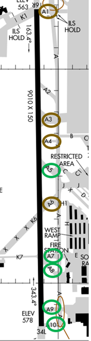
- PAE has experienced Wrong Surface Intersection Departures, especially when departing RWY16R/34L because of the angle of the TWYs.
- In these events, the aircraft involved read back the appropriate information to the controller but either started take-off roll or lined up in the wrong direction.
- To mitigate this, RWY16R intersection departures will be assigned TWYs A1, A3, A4 and A6 intersections.
- RWY 34L intersection departures will be assigned TWYs A10, A9, A8, A7 and A5 intersections.
- Pilots should always verify that their heading indicator aligns with the assigned RWY.
- When departing RWY16L/34R, advise TWR that you are ready for take-off only when you are number one at the hold short line for your respective intersection. This alleviates unnecessary frequency congestion since aircraft are unable to taxi past one another here.
Arrival/Landing
- Remain vigilant to your assigned RWY. PAE has experienced wrong surface landings.
- Ask ATC for clarification immediately if you are not sure of your assigned RWY.
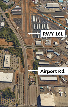
- Airport Road, which is a four-lane highway that runs north-south from the Boeing Fwy and the Boeing plant, may be confused as RWY16L before it makes a slight turn to the southeast. Pilots who are not familiar with the airport or the area, when making a “straight-in” approach from the north or turn a one/two-mile left base for the runway should be aware of this. This confusion is increased during sunset when visibility is impacted by the sun.
- The intersection of RWY16L/34R and TWYs G and TWY G3 is a place of frequent congestion.
- Arriving aircraft exiting the RWY at TWY G3 may receive complex taxi instructions to allow following aircraft to exit at TWY G3.
- Certain aircraft, like the Embraer 135 and the Boeing 737, are equipped with a Traffic Alert and Collision Avoidance System (TCAS), that may trigger an avoidance maneuver if that system senses a potential collision. This may involve a change of direction and altitude. To avoid this from happening in the traffic pattern, TWR may direct aircraft to make some adjustments like extending or widening pattern legs or even executing a 360-degree turn.
Special Traffic (Military / Commercial / Helicopter, etc.)
- Boeing test aircraft may have requests that are not routine.
- Accommodating regular commercial service may cause brief delays for other users to RWY 16R/34L.
- Aircraft may be asked to make a full stop taxi back or change to RWY 16L/34R if reasonable to accommodate these requests.
Additional Information
- Limiting cockpit distractions may reduce hear-back/read-back errors and help to reduce ATC workload and increase overall safety.
- Noise sensitive airport; for noise abatement procedure and traffic procedure call airport operations 425-388-5125. It is required that pilots adhere to noise abatement procedures unless otherwise instructed by ATC.
- First 1000’of RWY 16R is concrete.
- Avoid low level overflight of Boeing ramp and NE corner of airport due to jet blast.
NOTAMS
- See NOTAMS for the following Letters to Airmen (LTA:
- PAE Areas of Non-Visibility
- Closely Spaced Parallel Runways
- VFR PRACTICE APPROACHES