
President Donald J Trump International Airport (DJT)
President Donald J Trump International Airport (DJT) is a mixed-use airport located on the east coast of Florida, between the cities of West Palm Beach and Lake Worth. Pilots who are not familiar with the area should be aware that North Palm Beach County General Aviation Airport (F45) is located approximately 10 miles northwest with a very similar RWY configuration. The traffic mix at DJT consists of air carriers, corporate, and general aviation. Several flight schools use DJT to expose student pilots to towered airport operations. View a printable Pilot Handbook of the DJT information found on this Web page.
Know Before You Go
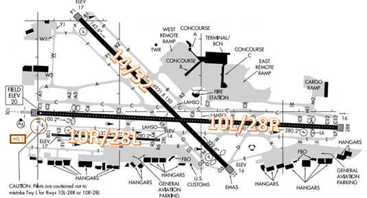
- The airport configuration consists of parallel RWYs 10L/R-28L/R along with RWY 14/32.
 Section Chart")
The airspace at DJT is Class C. (Refer to Sectional Chart)
DJT TWR operates 24 hours
Administrative Office open 0730L to 1600L M-F
Business Phone 561-275-1401
Below find various DJT-specific information and things to be aware of, as well as general information to inform your preflight planning. This will be reviewed quarterly and updated as needed. This information is to supplement the From the Flight Deck Videos that are produced by the FAA Runway Safety Group. Here you will also find information provided by the local air traffic controllers at the airport where you intend to fly. The information is subject to change. Not for navigation or legal* pre-flight action. Always refer to official pre-flight materials such as, but not limited to, NOTAMs, airport diagrams, VFR charts and airport construction notices for the latest airport-specific details.
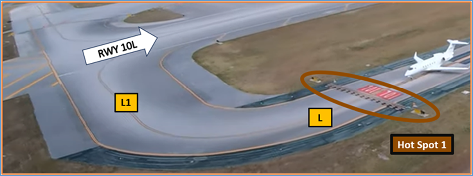
Hot Spots
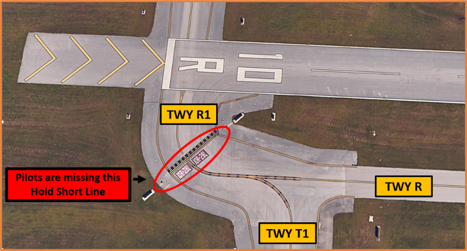
HS 1 - RWY 10L hold short line on TWY L is located prior to the bend in the taxiway.
- Pilots have failed to recognize that the hold short line is located on TWY L and have made the turn onto TWY L1 entering the Runway Safety Area for RWY 10L.
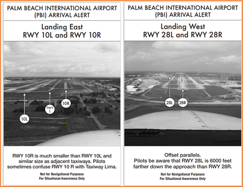
Wrong Surface RWY Landing Risks
See Arrival Alert Notices
- If available, back up all visual approaches with an instrument approach or GPS Waypoint to help ensure that you are lined up for the correct surface.
- RWY markings are white. Markings on surfaces not used for takeoff/landing like TWY markings, chevrons, RWY shoulder and RWY turn-on markings etc., are yellow.
- View the From the Flight Deck-Wrong Surface Landings video for additional mitigation strategies.
Surface Risk – Movement Area Cautions
Aircraft exiting Jet Aviation, during east traffic operations, and instructed to taxi via TWY J, TWY L, TWY E should note that TWY E comes up very quickly once you have turned onto TWY L.
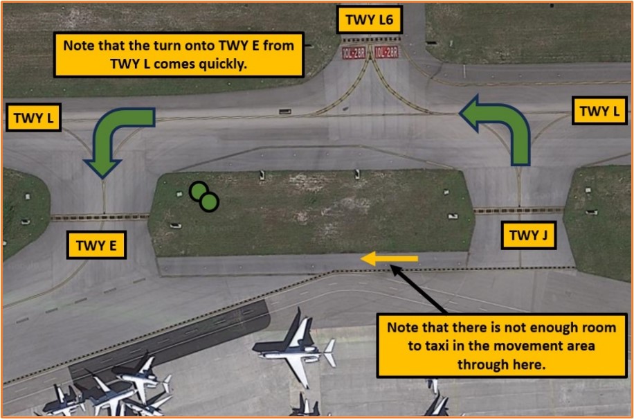
- Pilots sometimes miss the Hold Short line in the turn.
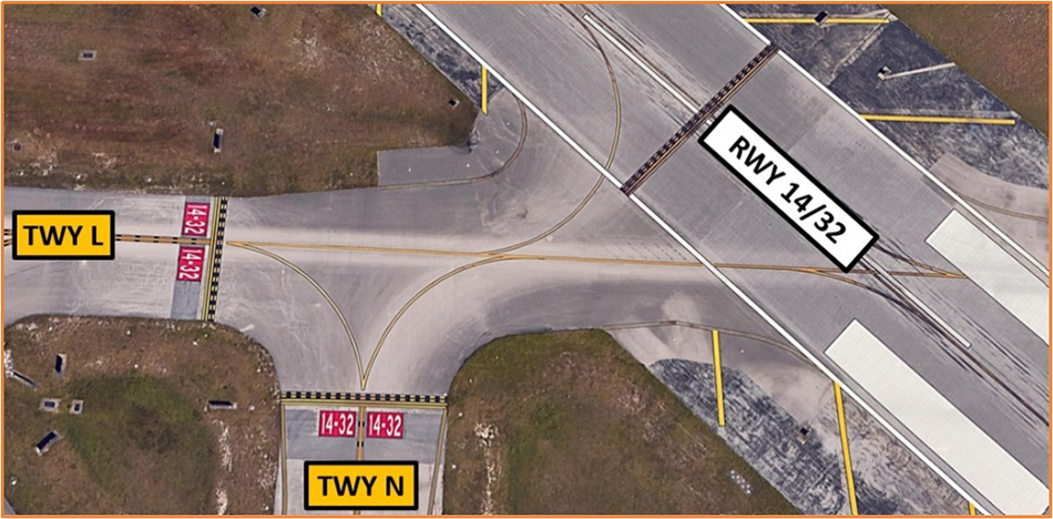
- Pilots have become confused when taxiing in the vicinity of TWYs L, N, and RWY 14/32.
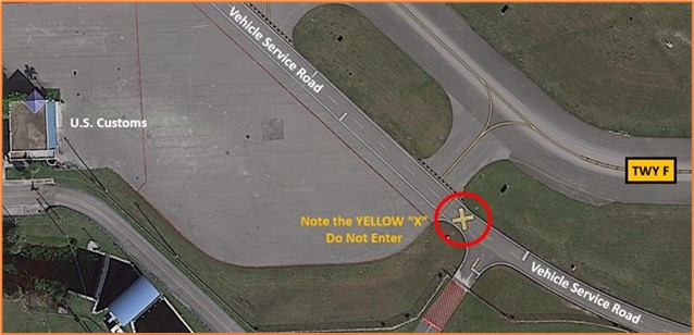
- There is a vehicle service road near the customs ramp. Do not confuse this Vehicle Service Road with TWY F.
RNAV X and RWY 28R
- Due to a 1NM Special Flight Rules Area around Mar-a-Lago, pilots can expect the RNAV X approach when inbound to RWY 28R. This approach is offset by approximately 30 degrees from centerline, with a correction to centerline on short final.
- Pilots have reported challenges identifying the runway lights at nighttime at low altitudes due to the offset approach as well as challenges with stabilized approaches on short final.
- Pilots holding short of RWY 28R have reported an expectation bias of checking to see if the final is clear prior to taxiing onto the runway for departure. Pilots report looking on the straight-in final and observing no traffic off their left, when the inbound traffic is actually on the offset final, which is behind and to the left when taxiing onto RWY 28R.
- Pilots should review the FAA’s TFR List for more information when flying in the DJT area. The easiest way to see if a TFR exists in your area is to filter the list by state.
Ground Control
- During periods of busy departure demand (i.e., Sundays from December – April), DJT will normally open Gate Hold for air carrier and business traffic.
- Generally, once an aircraft receives their clearance, they will be instructed to contact Gate Hold for an engine start time once they are ready to depart.
- Gate hold will then instruct the aircraft to monitor Ground Control at the appropriate time.
- Generally, Gate Hold tries to meter aircraft in 15-minute increments with an attempt to keep 7-10 aircraft at the end of the runway, ready for departure.
- Frequency congestion on Ground Control becomes an issue when ground stops or re-routes are initiated, because aircraft then start requesting re-routes or new times.
- It is recommended that you contact clearance delivery if you want to inquire about a new route or time.
- Do not contact ground control, as they are focused on aircraft movement on the airfield.
- The best practice is to be patient and wait for the controller to reach out to you, versus tying up the frequency while other aircraft are attempting to get their initial clearances.
- Another best practice is to monitor ground control (versus checking in) when instructed by gate hold. By monitoring ground control, the ground controller can ensure he/she talks to the right aircraft at the right time to set up the sequence for local control based on miles in trail, EDCTs, etc.
- Aircraft that taxi from Jet East ramp can expect taxi instructions via TWYs Juliette, Lima, Echo for RWYs 10L, 14, or 10R.
- Use caution for a quick left turn from Lima onto Echo.
Runway Crossings
- The controllers at DJT will be specific with runway crossing instructions.
- Ensure you readback all runway crossing instructions including your call sign.
Departure/Takeoff
- Aircraft should expect to fly the RNAV SIDS unless otherwise instructed or equipment limitations prevent this.
- During periods of heavy departure demand, you may be issued an initial departure heading and altitude. In these cases, expect to resume the assigned SID.
Arrival/Landing
- RWY 10R/28L is hard to see and the threshold for 10R/28L does not align with RWY 10L/28R. Pilots sometimes mistake TWY L for RWY 10R/28L. Ensure you have RWY 10R/28L clearly in sight prior to short final.
- Land and Hold Short (LAHSO) clearances may be issued to general aviation aircraft. Advise if you are unable to participate.
| LDG RWY | HOLD-SHORT POINT | AVBL LDG DIST |
|---|---|---|
| RWY 10L | 14/32 | 3117 |
| RWY 14 | 10L/28R | 4295 |
| RWY 28R | 14/32 | 3725 |
- Pilots requesting practice approaches should review NOTAMs for the Letter to Airmen: LTA-DJT-11 “IFR Separation Services for VFR Aircraft Conducting Practice instrument Approaches”.
Weather
- DJT airspace is exposed to thunderstorms predominantly from June through October.
- LLWAS equipment is available at DJT to help detect windshear around the field.
- PIREPs are always appreciated, including PIREPs for no significant weather when thunderstorms are forecast for the area.
Special Traffic
- DJT has a variety of helicopters based at the field, including law enforcement, local news, agriculture, and medevac.
- Use caution for low flying helicopters as you approach the field from the east and west.
- DJT uses a “shoreline” transition procedure to allow VFR aircraft to transition from north to south (or vice versa) at low altitudes. Generally, these aircraft will be at 500’ over the shoreline or 1,000’ 1NM offshore.
- Use caution when departing RWY 10L for these low flying aircraft.
Additional Information
- Due to the location of DJT, expect frequent Temporary Flight Restrictions (TFRs) for VIP movement and special events.
- Always check NOTAMs prior to flying in/around DJT airspace to ensure these TFRs are not in effect.
- TFR restrictions will be listed in the NOTAM.
- These TFRs are subject to frequent change.
- During periods of high volume at DJT, expect additional delays for practice approach requests.
- DJT will initiate programs to manage traffic inbound to DJT during periods of high arrival traffic. During these times, pilots changing their destination from a different airport to DJT may have their request denied.
- Operate transponders with altitude reporting mode and ADS-B (if equipped) enabled on all airport surfaces.