
General Downing Peoria International Airport (PIA)
General Downing Peoria International Airport (PIA), located 4 miles west of Peoria, IL., supports general aviation, corporate jets, cargo, military, commercial, and flight training operations. PIA has two military bases on the field. The 182nd Airlift Wing of the Illinois Air National Guard flies the C-130 “Hercules” and the Illinois Army National Guard operates “Chinook” helicopters. Military operations are a daily operation. This mix of pilot experience levels and aircraft capabilities make PIA a challenge. View a printable Pilot Handbook of the PIA information found on this Web page.
Know Before You Go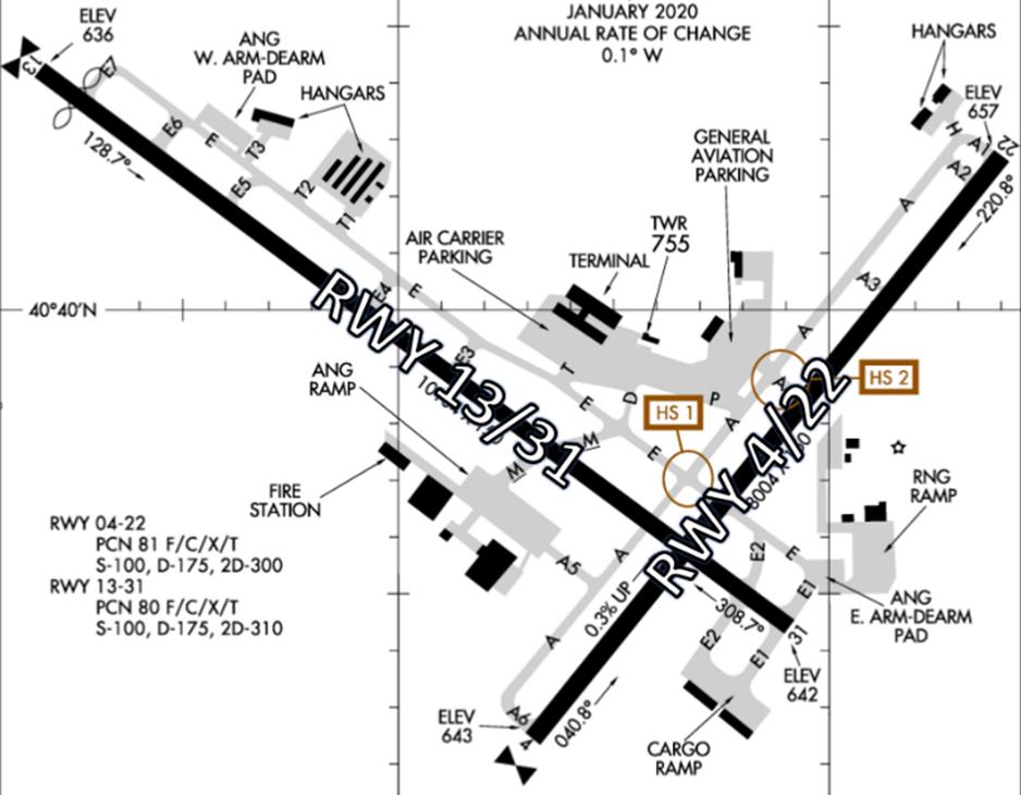
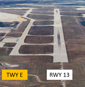
- The airport consists of two intersecting runways – RWY 4/22 and the longer RWY 13/31.
- Each RWY has a full-length parallel TWY which increases the risk for a Wrong Surface Takeoff or Landing.
- Military and cargo facilities are located to the south of RWY 13/31, while the remaining commercial facilities are located on the north.
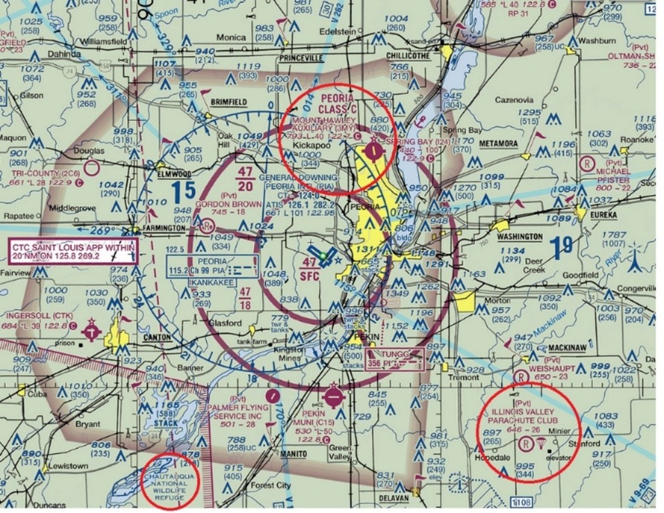
The airspace at PIA is Class C. (See Sectional Chart.)
PIA Tower Hours of Operation: Continuous – 24/7.
Administrative Office: Open 0700L to 1500L - M through F
Business Phone: 309-697-0751
Below find various PIA-specific information and things to be aware of, as well as general information to inform your preflight planning. This will be reviewed quarterly and updated as needed. This information is to supplement the From the Flight Deck Videos that are produced by the FAA Runway Safety Group. Here you will also find information provided by the local air traffic controllers at the airport where you intend to fly. The information is subject to change. Not for navigation or legal* pre-flight action. Always refer to official pre-flight materials such as, but not limited to, NOTAMs, airport diagrams, VFR charts and airport construction notices for the latest airport-specific details.
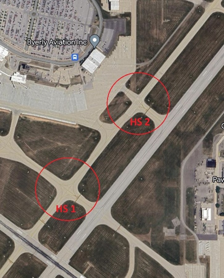
Hot Spots
- HS 1: Complex intersection in close proximity to the two RWYs.
- HS 2: Short taxi distance to RWY 4/22.
Wrong Surface Intersection Takeoff
- At PIA, intersection departures are authorized. It is critical to verify correct RWY line-up to avoid a potential conflict with landing aircraft.
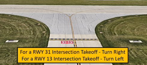
- Prior to entering the RWY and again when lining up on the RWY, check your Magnetic Compass and your Horizontal Situation Indicator (HSI) to verify correct direction.
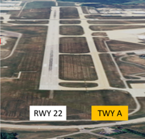
Wrong Surface TWY Takeoff
- A risk exists for pilots to take off on a TWY whenever a TWY runs full-length and parallel to a RWY.
- At PIA, TWY A and TWY E run full-length and parallel adjacent RWYs.
Wrong Surface TWY Landing
- As with taking off on a parallel TWY, a risk exists for pilots to land on a TWY whenever a TWY runs full-length to a RWY.
- At PIA, TWY A and TWY E run full-length and parallel adjacent RWYs.
Surface Risk – Movement Area Cautions
- Hot Spot 1 is located at the intersection of TWY A and TWY E. Pilots tend to turn in the wrong direction here.
- Hot Spot 2, located at TWY A4, is a short, straight, and direct path from the ramp to the RWY. The RWY Hold Short Marking comes up quickly after crossing TWY A.
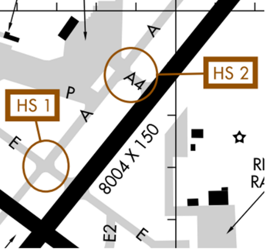
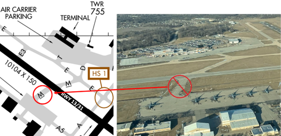
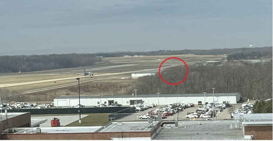
- TWY M, south of RWY 13/31, is only used by ANG (military) aircraft. (See illustration below)
General
- Wildlife in the vicinity of RWYs & TWYs. Report to TWR because they might not be visible to controllers.
Traffic Patterns
- PIA does not have a published traffic pattern altitude. Please maintain a normal standard traffic pattern in accordance with the AIM 4-3-3 and the FAA Airplane Flying Handbook unless otherwise approved or directed by the controller. Please request all early turns and non-standard traffic patterns from the controller.
- Propeller-driven aircraft 1000 AGL
- Large and turbine-powered aircraft not less than 1500 AGL
- Helicopters not less than 500 AGL
Ground Control
- Ground Control (GC) & Clearance Delivery (CD) are commonly combined.
- Advise ground control if you’ll need a longer than normal run-up prior to departure.
- GC/CD restrict VFRs at or below 5000’ MSL. You may get higher when you are handed off to St Louis Departure.
- Because we are Class C airspace, TWR must request a heading or on-course from St. Louis Departure for VFR & IFR departures. If you are not given on course for departure from TWR, then St. Louis Departure will give you that instruction.
- The radio reception behind the building at the Byerly FBO and the Mark Marquis helicopter ramp can have interference because it blocks the signal. Please pull away and try again or try another radio.
- Areas not visible from the Tower are H, A1, A between A1 & A2, T3, and the West Arm-De-Arm pad.
RWY Crossings
- Read back all hold short instructions with your full call sign in the same transmission.
Takeoff/Departures
- Most common intersection departures are:
- RWY 22 at A4
- RWY 4 at E
- RWY 31 at A
- RWY 13 at E5
- You may encounter a wake turbulence delay at intersections due to preceding aircraft.
Arrival/Landing
- Please take first available TWY or say Parking Destination if requesting a longer landing.
- St. Louis Approach will sequence all IFR and VFR aircraft by assigning a RWY and pattern entry. The Tower may change this if needed.
- Two-way radio communications and operational transponder are normally required for operations within Class C airspace, but operations without radio communications or transponder can be conducted by special arrangement with the TWR.
- There is a lighted powerline on approach to RWY 4.
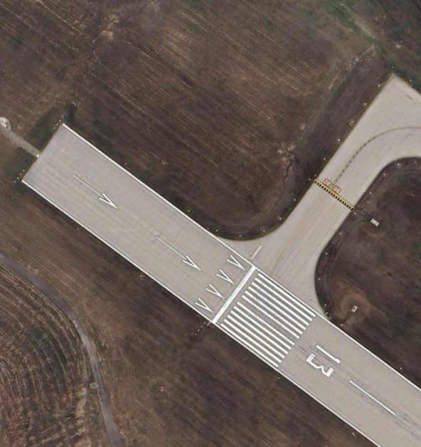
- RWY 13 has a Displaced Threshold. The portion of RWY behind a displaced threshold is available for takeoffs in either direction or landings from the opposite direction.
Weather
- High wind gusts possible.
- During cold weather operations, RWY de-icing is a slow process and will shut the airport down for large portions of the day. ATIS and NOTAMs will relay this information.
Special Traffic (Military / Commercial / Helicopter, etc.)
- The airport serves military aircraft, part 121, and part 135 operators.
- PIA is home to the Peoria Air National Guard and the Army National Guard and a flight school.
- The Army National Guard uses the grass between RWY 4/22 and TWY E on the east side for military training, arrivals, and departures, but this is outside the RWY and TWY Safety Areas.
- Helicopters commonly land and depart the GA Ramp in front of the Byerly FBO and the NE Hangars.
Additional Cautions
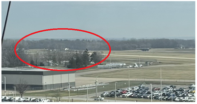
- When arriving from the N/NE, avoid overflying 3MY (Mount Hawley Auxiliary Airport) below 2400’ MSL. 3MY is non-towered and aircraft are not in contact with ATC.
- Parachute operations at Illinois Valley Parachute Club from surface to 14,500’ MSL.
- When arriving from the SW through Howard & Pruitt MOAs, Contact St Louis Approach on 125.8 to verify MOAs are active/inactive.
- Chautauqua National Wildlife Refuge is located 20 SW on final to RWY 4.
Additional Information
- Run Up Areas are limited.
- RWY 4 has a small corner that a small aircraft could use at the intersection of A1/A.
- RWY 22 does not have an area.
- RWY 31 has the East Arm-De-Arm Pad available near TWY E/E1.
- RWY 13 has a small corner that a small aircraft could use at the intersection of TWYs E7/E.