
The Air Up There Podcast
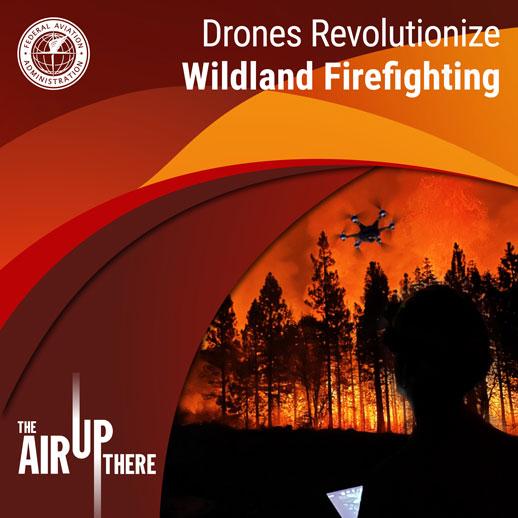
Drones Revolutionize Wildland Firefighting
Season 3,
Episode 6
Published:
The use of drones for fighting wildfires is a "hot" topic, with more than 6 million acres of forest burned this year. When they are used by emergency responders they have proven to help suppress and contain massive blazes, and save lives on the ground and in the air.
Drones have revolutionized wildland firefighting, and can come equipped with infrared cameras and ignition payloads for wildfire control. The FAA works with federal and state agencies to find ways to support firefighting efforts, including approving hundreds of emergency airspace authorizations to fly drones.
Tune in as we discuss various drone initiatives and programs, and their role in redefining aviation operations for wildfires. You'll hear from Mike Sheldon, an air traffic security expert for FAA, Dirk Giles, the Forest Service's drone program manager, and Pete York, a CAL FIRE captain.
Read our latest blog "Drones Revolutionize Wildland Firefighting." If you're interested in more stories on drones and public safety, check out our episode from Season 1 titled Drones for Good.
- Download (MP3)
Kevin: Welcome to The Air Up There, a podcast about the wide world of aviation and aerospace. I'm Kevin Morris, the FAA drone guy, and I'm here with my co-host Talisa White to talk about how drones are a key piece in fighting wildfires.
Talisa: Yeah, Kevin. Sadly, another year with more than 6 million acres of forest burned. Drones are totally redefining aviation operations for wildfires, and emergency responders really pushing innovation. They're flying drones equipped with infrared cameras and ignition payloads for wildfire control.
Kevin: And generally speaking, flying a drone near or over an active wildfire is illegal. However, drones can be a big help to crews fighting these fires, and we are working with federal agencies like the Forest Service to find ways to support firefighting efforts. The FAA protects airspace around wildfires through temporary flight restrictions, or TFRs, designed to keep unauthorized drones away from traditional firefighting aircraft. However, we also have the special governmental interest process, or SGI process, which allows drones to join the fight by providing authorizations for drones in that airspace.
Talisa: Oh, great points, Kevin. And regarding the influx of special authorization requests, our colleague, Chris Troxell, spoke with Mike Sheldon, an FAA air traffic security specialist about his role in approving hundreds of emergency authorizations to fly drones. Here's a clip.
Mike: We had to come up with a system so we could allow first responders to get into access to places immediately and quickly, without all the red tape and without all the paperwork. That's where it started for us as far as the drones and getting into like the fire TFRs out west because it was kind of a perfect storm for us because it was temporary flight restrictions for the fires and it was access for the drones. And we were the experts in both of those things. So it landed on our plate. And what we found that when you get out towards the firefighting, the drones were just a great, great tool, resource. They were able to use the drones to go into the fires and find out where the hotspots were in places where they just couldn't put human beings because it was too dangerous.
Chris: Who is using drones for this purpose? What agencies, what groups are you issuing these authorizations to?
Mike: So breaking it down, and basically, we're going to talk about forest fires today, you get the Department of Interior; they're using them quite successfully in conjunction with the Forest Service in actual fighting of the fires. But additionally, we're getting some of the different colleges; they're using them to get data. Unfortunately, there's a lot of stuff to be learned from these fires that can't be learned when the fires aren't occurring. So this is an opportunity for them to access those areas and to get data — what type of smoke and what kind of oxygen levels, all kinds of different things that are obtained that's essential for research. Colleges are using it. But mostly we're getting Department of the Interior and firefighting side of it. Different fire departments are getting drones; almost every fire department now has got their own drone program. A lot of the law enforcement agencies have their own drone programs, and they're all fairly new at it. But they're getting really smart really fast.
Chris: When did this start for forest fires? Is this the first year, or have you been doing this since last year even before?
Mike: We've probably been involved in it for about four years, three or four years. Quite frankly, I think a lot of the people who were involved in firefighting were afraid of using a UAS or drones; they were afraid that they're going to get those in there, they're afraid they're going to be more of a hazard than they would be a help. It's all blended together for me because I've been doing it a while now. But once we started to realize that this is such a useful tool, forest organizations have really supported it wholeheartedly. It's been a complete 180-degree turn on it. And now they're getting all the UAS authorizations they can just to help do the missions that they're trying to do. We get calls in the middle of the night. It's one of those things that when we get a call, it's an emergency. So we have to act immediately. And we get those guys in as quickly as we have to. Because we know that those guys are working around the clock. And the amount of fires has just gotten so difficult over the last few years that it just feels good for us to feel like we're helping out. And you know, as citizens, we just feel good that our work is being used for something as important as this.
Chris: Is your group involved in the education and training of how to use drones in these various operations?
Mike: We've gone out. Before COVID, we were doing a lot more of it; it's been a little bit more difficult because there hasn't been as many events. But we've been sending our folks out to different organizations; we probably would do about seven or eight a year that we've get hundreds of people at them. And it was always well attended by groups that were starting to programs up. So it was really a great opportunity for us to help them and for them to help us. We had to figure out ways to do things that just couldn't be done any other way. We had to do a tethered drone to get communication and resources into the air, and didn't dare allow human beings to get into where the fire was. So were using a tethered drone that could go off and they could keep it in place for hours at times and bring it back down when they needed to; we had to figure out how to do it because, quite frankly, there's no book on what we're doing because this is technology that didn't exist. It's only been a few years this has been so widespread. So we had to come up with a book on our own, and we learned a lot by trial and error; it's a good way to learn. And once you figure out something that works, you stick with it.
Kevin: So let's talk a little bit about drone training. It's been said that a good pilot is always learning, and with the rapid changes we see in the drone industry, this is especially true. The FAA sets the standards for operating a drone and provides tons of resources to help drone pilots fly safely, including testing and training.
Talisa: So Dirk Giles said his group at the Forest Service takes part in a national inter-agency training program that is developing highly skilled drone operators for their tough missions. They have a robust program there of 65 operators, and he's aiming to double that number next year. They've requested more than 80 special waivers from the FAA this year.
Kevin: Wow. And drone programs are rapidly growing across the federal government, universities and private companies for so many applications. Let's hear Chris's conversation with Dirk.
Chris: It's clear that drones have become a useful tool for your group. Can you tell me why they become so useful and how you're using them at the Forest Service?
Dirk: Sure, you know, the first wildland fire mission occurred back in 2015. Since then, we've seen nothing but an incredible growth rate. We get a lot of requests on an annual basis, and it's only increasing every year. But if you really looked at like that 2015 timeframe, just the platform that we were using versus what we're using now, increasing endurance, better sensors that are integrated into the airspace; it's an incredible tool to heighten the situational awareness of on-the-ground decision makers right now. And so if they can have actionable intelligence with their surrounding scenarios, that's a game changer. Now we're really beginning to explore the more tactical uses — advancements in payload technologies, such as aerial emission, for example. We're pretty proud of that one right now; it's really beginning to support the boots on the ground, from a tactical aspect versus just (on-the-scene reporting) capability, we can start to now be proactive instead of reactive with management tactics. So for example, there was a fire rising over a hill coming down into a community, the aerial ignition modules that were on the incident, they pulled a really late night, and they just slowly walked the fire down from the ridge top, just adding a little bit of fire here and there, and we can really begin to control the intensity. And so if we can back it down nice and neat, it's nice and easy, it's a surface fire instead of what we call a crown fire where, you know, if you got fire at the base of a hill, it's going to run up and just kill everything in its path. But now we can begin to manipulate it. And it's easier on the ecosystem; it's easier in the landscape. And then post-fire, we're not dealing with erosion issues or emergency stabilization of soils near critical watersheds.
Chris: I never would have thought that you would light fires in this greater effort to contain wildfires. Oh, yeah, it's just as much backwards thinking. But you explained why you're doing that. And so correct me if I'm wrong — by lighting an additional fire, you're then able to change the way that this larger forest fire is burning?
Dirk: Yeah, for sure. You know, to really break it down, there's two types of incidents, right? So there's initial attack. There's a fire that just started right now. And we go really aggressively at it, we are pretty successful, we'd catch 90 percent of all initial attack fires. So our operational capability, initial attack is incredible. But for those 5 percent or more that escape initial attack, it moves into extended attack. And so now you're really beginning. It's like these major fires in California and Washington and Oregon, Montana, Idaho, now you begin to start to move, not aggressive, but you have to think strategically and tactically. So strategic ridgelines, construct handlines or containment lines. We do most often we use fire to fight fire. So this is just another tool in our toolbox to really increase our safety. And we do aerial ignitions from helicopters routinely. We've been doing that for decades. But now this is a new tool that can't really treat a landscape level scenario. But it can, it can really impact the case where maybe some of our piloted assets should not be flying a helicopter at 300 above ground level. That has its own hazards and risks. You got human life involved. So, if something goes wrong, there's probably going to be an accident. So now we can use an unmanned system within that profile to be a little bit more surgical and strategic of where we're adding fire, how much fire we're putting on the ground, we're also opening up opportunities to not just fly during day or VFR conditions, we can now fly at night, or in the middle of an inversion due to the IR cameras that were utilized. So it's really opened up our operational capability from just during the day to around the clock. But if we really look at our history, there's been four helicopter accidents within that prescribed fire mission profile with 16 employee fatalities over a course of eight years. And so trying to move to a new system to increase our employee safety should be … it's my motivation to move forward and faster. It's something I'm really focused on to just increase employee safety. There's normalized hazardous risks that employees face on a daily basis. And so that's the beauty of unmanned technologies is that now we can introduce a new conversation on risk management and risk acceptance, essentially.
Chris: And what is this aerial ignition?
Yeah, it's a very special operation. And so it's not our basic run of the mill operators; it's the best that we have; it's really only been in existence for about two, two and a half seasons so far. And essentially, it's a payload that has a hopper in it. That hopper, there's some spheres that look like … we call them ping-pong balls, started out with like seven spheres and now moved to like 100 spheres, and then up to 450 spheres where we're currently, and then that sphere will ping-pong down through the canopy to the surface floor. And about 20-30 seconds later, it starts with small ignition. So we're really seeing the safety case of using these systems within our mission profiles, not just wildland fire, but also our prescribed fire mission sets. So intentionally lighting the landscape on fire to achieve desired management outcomes and objectives. We're still learning a lot more about what we can do this year was an incredible year of learning, there's a lot of fire on the landscape this summer, what we are seeing now is that we can start to now be proactive, instead of reactive, for example, there's a fire written over a hill coming down into a community, the aerial ignition modules that were on the incident, and they pulled a really late night, and they just slowly walked the fire down from the ridge top, just adding a little bit of fire here and there. And we can really begin to control the intensity, if we can back it down nice and easy. It's a surface fire instead of what we call a crown fire where, you know, if you got fire at the base of a hill, it's going to run up and just kill everything and pass but now we can begin to manipulate it, or it's easier on the ecosystem, it's easier in the landscape. And then post-fire we're not dealing with erosion issues or emergency stabilization of soils and critical watershed , you know, I would like to push upon to that within the national wildfire coordinating group, that's the standards that everybody operates on within the wildland fire mission set, and so we have a UAS standard, it's called PMS, 515. So, a lot of our incidents we're integrating with piloted aircraft. So we have scripts and deconfliction procedures and protocols. And we take it very seriously because we're trying to integrate into a traditional airspace. Operating on standards and scripts is utterly the most important thing as we begin to expand this use case out even more. I think we could be a tremendous partner to the FAA of how is our scripts and standards, increasing access to the airspace but doing as efficient and coordinated and safely.
Kevin: About the helicopters — that's just a perfect example of how drones are the solution to some high-risk aerial missions. Traditional aircraft like helicopters will always have a large role in these operations. However, when the risk nears the unacceptable range, drones can really shine I just love hearing about how drones are used for good.
Talisa: Definitely. CAL FIRE just started their drone program this year and are ready they're reaping enormous benefits. Chris had the chance to talk with one of the two licensed pilots, and he's based in South Tahoe.
Chris: How are you guys using these drones? Can you give me an example of how you've used them recently this year?
Pete: Yes, I think one of the highest use cases that we've seen so far this year, at least with CAL FIRE's program and it being so new is really down at the fire-line levels being able to provide real-time incident information to the folks that are right on the ground right on a smaller piece of line. So we do have a technologies in both manned and unmanned aviation that allow us to do some mapping products and do some intel stuff from a higher altitude that doesn't affect the ground troops. But being able to launch a UAS from the fire line with the decision-makers, the person responsible for that piece of line, and be able to give them direct information, show them exactly what the fire is showing, the fire behavior, and do this both day and night, in heavy smoke conditions when the manned aviation assets aren't available to fly. It's vital, it gives them really good essay to what's going on before they engage in areas they might not have better Intel for.
Chris: What kind of data are you collecting with these drones and relaying over to the first responders?
Pete: By far, the data that's asked for the most would be the IR, the infrared. It allows you to see through the smoke. You can see where the fires' edges are relative to maybe a control line that you've already put in, or a dozer line. Being able to provide that real-time data was definitely what people were super stoked to have when they're trying to make those tactical decisions at night, or during the day when the smoke conditions were such that you're unable to see and get a real clear picture what's going on. This just gives them another set of eyes and a slightly different visual look to kind of help them better make a plan. This program is very new. And one of the focuses we have this program is that it aligns with our federal partners, really making sure that everyone's on the same page when it comes to the operations of UAS and airspace coordination. That is a nationwide standard that we're all trying to uphold, so that apples or apples when we get out. Whether it's a CAL FIRE employee or a federal employee flying UAS on a wildland fire, there should be no confusion from anyone that they're getting the same product. From an operational standpoint, there's been a lot of groundwork obviously covered over the last year and a half, with the FAA to get where we are our plans with UAS stretched out much further than just the wildland piece, although the wildland piece is a large part of what's driving this program. But also, on the other side of that, just for our foresters, and our folks that make decisions on the health of the forest, we're able to go out and do some mapping projects for them, survey some land, etc. I think there's a lot of use cases, like I said earlier, that are going to help our foresters make better decisions and give them a lot more intel they didn't have before as they start moving forward and kind of managing the forest maybe a different way.
Kevin: I can just tell that Pete is excited about growing this program. All the great benefits that lie ahead. Drones are literally saving lives and creating a more sustainable aviation system. Just think of all the operations were battery-powered drones can replace gas-powered piloted aircraft, not just for safety enhancements, but there are potential fuel savings and emissions reduction as well.
Talisa: For sure. If you're interested in more stories on drones and public safety, we have an episode titled Drones for Good in our first season. And that's our show for today. The Air Up There is a podcast from the Federal Aviation Administration. If you liked today's episode, remember to subscribe and share it with someone else. You can find the FAA on social media. We're @FAA on Facebook, Instagram, and LinkedIn and @FAANews on Twitter and YouTube.
Kevin: Alright, thanks for listening!