
Prescott Regional Airport – Ernest A Love Field (PRC)
Prescott Regional Airport-Ernest A Love Field (PRC) is a medium sized, multi-use airport located 7 miles northeast of the city of Prescott, Arizona. PRC is a commercial service airport and is one of the nation's top 50-busiest airports due to intensive fixed wing and helicopter flight training. In addition, the airport supports recreational general aviation, corporate aviation, air cargo, military and U.S. Forest Service fixed wing and helicopter firefighting operations. This mix of pilot experience levels and aircraft capabilities make PRC a challenge for controllers and pilots alike. View a printable Pilot Handbook of the PRC information found on this Web page.
Know Before You Go
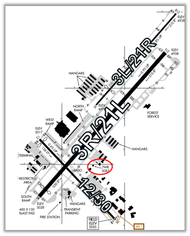
- RWYs 3R/21L and RWYs 3L/21R are staggered and run parallel to each other which increases the risk of a Wrong Surface Landing
- RWY 3R/21L is much longer and wider than RWY 3L/21R.
- A third runway, RWY 12/30, intersects RWY 3R/21L.
- There are several full-length parallel TWYs adjacent to the RWYs. This also increases the risk for a Wrong Surface Takeoff or a Wrong Surface Landing.
- Aircraft departing RWY 21L continue RWY heading until across HWY and make immediate left turn.
- RWY 21L designated calm wind RWY.
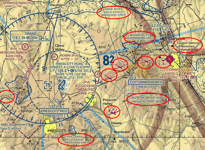
The airspace at PRC is Class D with a 7,500’ MSL ceiling. (Refer to Sectional Chart.)
Below find various PRC-specific information and things to be aware of, as well as general information to inform your preflight planning. This will be reviewed quarterly and updated as needed. This information is to supplement the From the Flight Deck Videos that are produced by the FAA Runway Safety Group. Here you will also find information provided by the local air traffic controllers at the airport where you intend to fly. The information is subject to change. Not for navigation or legal* pre-flight action. Always refer to official pre-flight materials such as, but not limited to, NOTAMs, airport diagrams, VFR charts and airport construction notices for the latest airport-specific details.
PRC Tower Hours of Operation: 0600L to 2200L
Administrative Office: Open 0700L to 1500L M to F
Business Phone: 928 - 541 - 3800
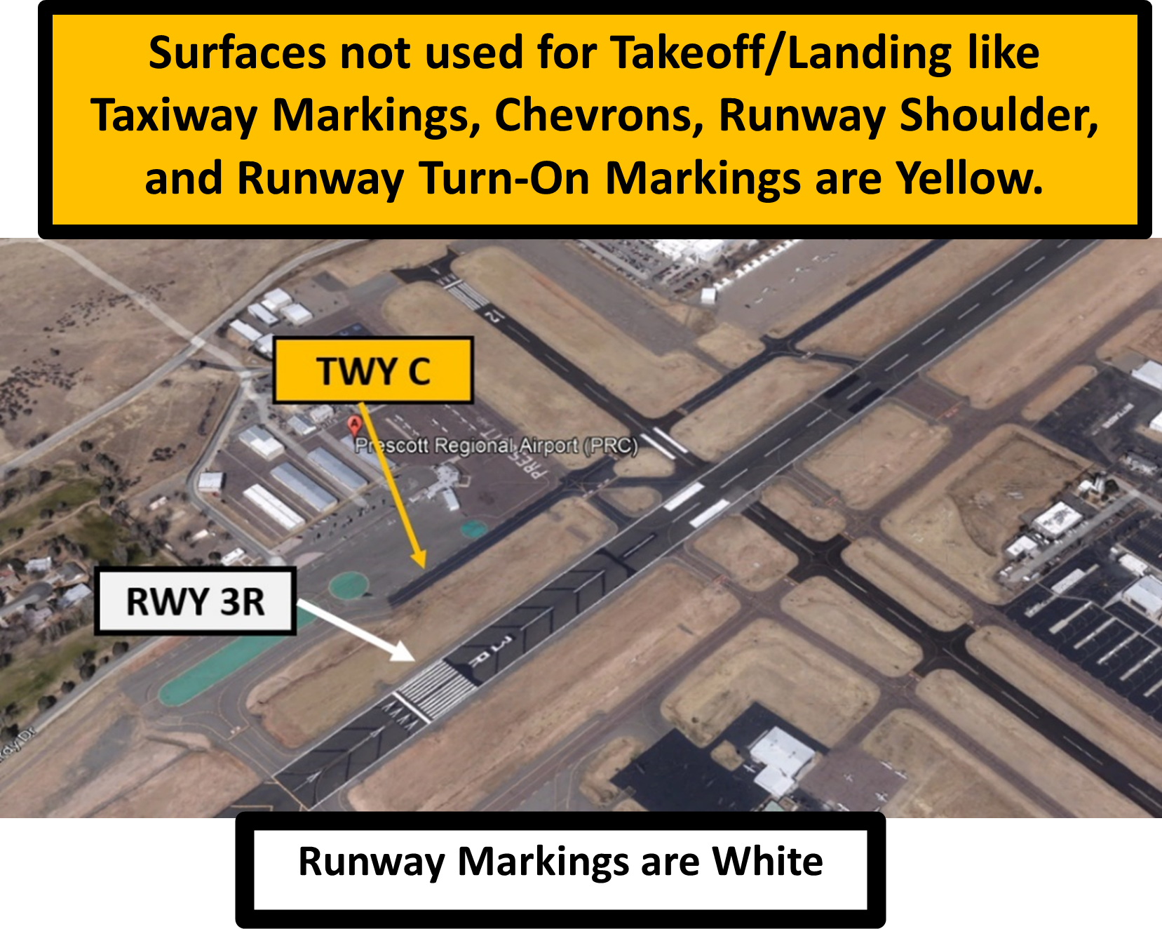
Hot Spots
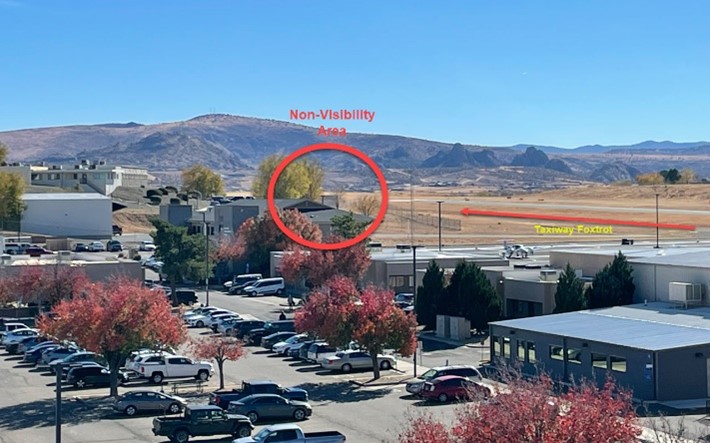
HS 1 Run up area at TWY F1 not visible from the TWR.
Wrong Surface Takeoffs
- Always verify that you are on the actual RWY from which you have been cleared to depart.
- Also, be aware that at various airports, pilots have departed on a TWY.
- Verify proper heading prior to starting takeoff roll on all departures.
- Verify that you are turning in the correct direction onto the appropriate RWY when performing an intersection departure. Check your magnetic compass.
Wrong Surface - Parallel TWYs
- A Wrong Surface Risk (Takeoff or Landing) exists whenever a TWY parallels the RWY. Positive identification of the RWY needs to be a part of every before takeoff and landing checklist. (See illustration below.)
Wrong Surface Landings
(See Arrival Alert Notices (AAN)
A Wrong Surface Landing Risk exists when there are parallel RWYs and especially when those RWYs have staggered thresholds.
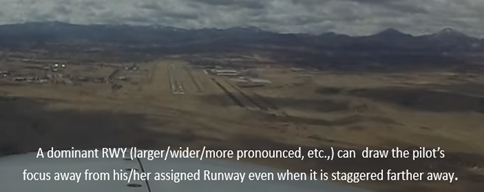
In the illustration below, RWY 3R will come into view prior to RWY 3L due to the large amount of stagger and displaced threshold.
Surface Risk – Movement Area Cautions
- Be alert for extensive helicopter training ops on TWY A, TWY B, and TWY D.
- Hot Spot 1, runup area located at TWY F1 is an ATC Non-Visibility Area and aircraft are not visible from the TWR. See illustration below.
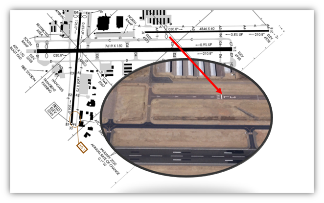
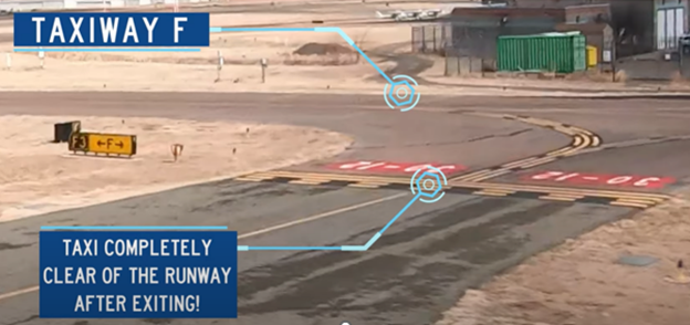
RWY Hold Short Markings
- Adjustments to the Runway Safety Areas have necessitated the movement of the RWY Hold Short Marking further away from the RWY centerline. Sometimes pilots are not expecting the Runway Hold Short Markings soon after beginning the turn towards the RWY.
- Completely cross Hold-Short Lines when exiting the RWY. Sometimes you may have to enter a TWY when clearing the RWY. TWR is aware and managing aircraft on the TWY accordingly. (See example illustration at TWY F below.)
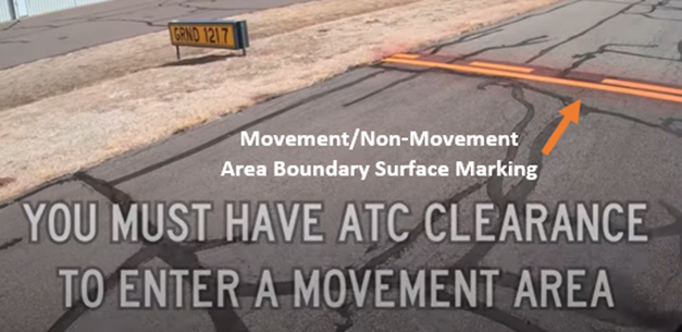
Movement / Non-Movement Areas
- The Non-Movement Area is that part of the airport that is not controlled by ATC (e.g., ramps, aprons, and taxi-lanes).
- The Movement Area (TWYs and RWYs) is controlled by ATC, and you must have clearance prior to entering any Movement Area
Additional Cautions
- Voluntary noise abatement procedures in effect – contact airport operations at 928-777-1150.
- Wildlife in the vicinity of RWYs and TWYs.
- Numerous Bald Eagle breeding areas and wilderness areas surround PRC. The Tuzigoot National Monument lies about 23 miles to the east. (Refer to Advisory Circular (AC) 91-36 Visual Flight Rules (VFR) Flight Near Noise-Sensitive Areas)
- Numerous Glider Operations east of PRC.
- Winch tow in use up to 2500 ft AGL 6NM east of Goodwin Memorial Glider port.
- Parachute activity over Cottonwood Airport which is 20 NM east of PRC.
- Granite Mountain rises to 7,640’ MSL west of PRC.
- RWY 3L/21R is closed from 2200L to 0600L.
- LAND AND HOLD-SHORT OPERATIONS (LAHSO) – Landing RWY 21L
- Use caution on RWY 12/30 for change in RWY gradient at intersection of RWY 3R/21L.
General
- PRC has extensive pilot training operations.
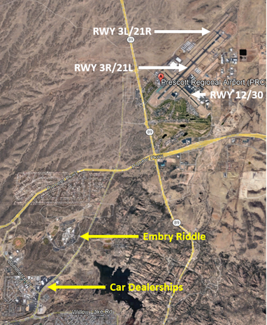
Traffic Patterns
- Usually, traffic patterns will match your assigned RWY.
- RWY 21L will be left closed traffic and RWY 21R will be right closed traffic.
- Your pattern may also be extended, specifically on the upwind. Many controllers will extend aircraft upwind to the “campus” or the “dealership”.
- The campus is Embry Riddle and beyond that are numerous car dealerships. (See illustration to left)
- Controllers may restrict pilots to at or above 6500’ MSL to avoid traffic pattern.
Runway Crossings
- The new airport layout has changed a regularly used crossing point at TWYs C4 to D4. This is no longer a straight crossing, and a pilot will have to turn onto the RWY for a portion of the crossing.
- All crossings are expected to be without delay. Controllers will often emphasize “no delay” in the crossing instruction.
- Controllers need to build space for crossings and short delays should be expected specifically during high volume.
Takeoff/Departure
- VFR departures are commonly told to fly straight out. Depending on airport configuration and direction of flight, pilots will often be required to contact another controller to turn on course.
- PRC will be reading all IFR clearances “via radar vectors”. Diverse Vector Areas (DVAs) have been established at some larger airports for a safe and standardized way to guarantee obstacle clearance for aircraft departing on radar vectors. If a pilot is unable to comply with the climb gradients of the DVA they are expected to inform the controller prior to receiving clearance. PRC DVA climb gradient information is found under Special Alternate Minimums found in the Terminal Procedures Publication: PRC DVA Climb Gradient.
- It is expected at PRC for pilot to pull up to the RWY Holding Position Marking and contact the appropriate tower frequency when ready.
- When in the runway departure queue, do not call ready for takeoff unless you are at least number two or have been instructed to do so.
- TWY C has no runup area. You can do a runup on TWY C if you are not blocking an intersecting TWY and the controller has been informed.
- [Aircraft departing RWY 21L continue RWY heading until across highway and make immediate left turn.]
- [20 ft drop-off 300 ft from approach end of RWY 12.]
- [RWY 21L designated calm wind RWY.]
- [Use caution on RWY 12/30 for change in RWY gradient at RWY 03R-21L intersection.]
- [RWY 03L/21R not available for air carrier operations.]
Arrival/Landing
- Initial arrival frequency assignment can be found on ATIS and is based on your position from the airport.
- Pilots are expected to exit the RWY at the first available TWY.
- When exiting a RWY ensure that your entire aircraft is beyond the yellow RWY Holding Position Marking painted on the TWY pavement.
Communications
- Listen on frequency before keying up the mic. Avoid stepping on controller transmissions to another pilot or interrupting a pilot’s read-back.
Weather
- High wind gusts possible.
- During cold weather operations, deicing RWYs is a slow process and will shut the airport down for large portions of the day. ATIS and NOTAMs will relay this information.
Avoidance Areas
- DRK VORTAC and finals for parallel RWYs should be avoided if possible. These areas get congested with numerous aircraft on practice approaches into PRC.
NOTAMS
- See NOTAMS for the following Letters to Airmen (LTA):
- VFR Practice Approaches
- FAA Aircraft Wake Turbulence Re-Categorization (RECAT) Considered Wake Turbulence Separation Standards (CWT) Implementation within Phoenix Terminal Radar Approach Control (TRACON) and Luke Air Force Base (AFB) Radar Approach Control (RAPCON).