
Reno/Tahoe International Airport (RNO)
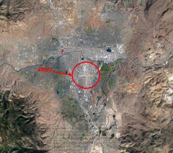
Reno/Tahoe International Airport (RNO) is a medium-sized multi-use airport, located on the east edge of the city of Reno. The traffic mix consists of small single-engine aircraft to heavy military transports. Varying pilot experience levels, combined with a diverse aircraft and traffic mix, make Reno a challenge. The airport also experiences a major increase in traffic during the annual Burning Man Festival. Be aware that the runways at RNO were recently renamed due to magnetic variation. Active runways are now 17/35L, 17/35R and 8/26. View a printable Pilot Handbook of the RNO information found on this Web page.
Know Before You Go
- RNO is surrounded by higher terrain in all directions. Being located downwind of the Sierra Nevada Mountain range often results in challenging weather conditions. Extreme winds, windshear, severe turbulence, mountain obscurations, and high-density altitude routinely affect airport operations.
- RNO has complex instrument procedures with steeper than standard IFR climb and descent profiles due to the high mountainous terrain.
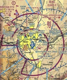
- The airspace at RNO is Class C. (Refer to Sectional Chart.)
Below find various RNO-specific information and things to be aware of, as well as general information to inform your preflight planning. This will be reviewed quarterly and updated as needed. This information is to supplement the From the Flight Deck Videos that are produced by the FAA Runway Safety Group. Here you will also find information provided by the local air traffic controllers at the airport where you intend to fly. The information is subject to change. Not for navigation or legal* pre-flight action. Always refer to official pre-flight materials such as, but not limited to, NOTAMs, airport diagrams, VFR charts and airport construction notices for the latest airport-specific details.
RNO Tower Hours of Operation - Continuous
Administrative Office Open 0600L to 1430L M-F
Business Phone 775-324-8500
Hot Spots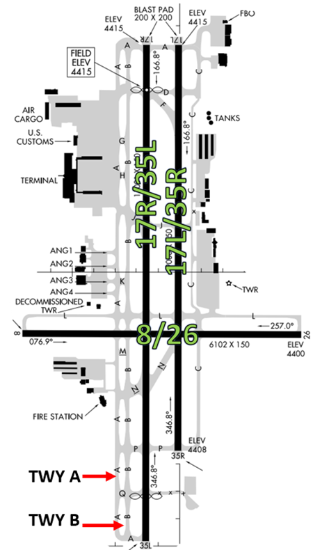
- There are no Hot Spots.
Airport Geometry
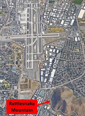
- Parallel runways with staggered thresholds, along with dual parallel TWYs make wrong surface events a potential issue.
- The airport configuration consists of parallel, staggered RWYs (RWY17L/35R and RWY 17R/35L). RWY 08/26 intersects the parallel RWYs at a 90-degree angle.
- Dual full-length parallel TWYs (TWYs A and B) are located west of the parallel RWYs.
Wrong Surface Taxiway Takeoff
- Aircraft taxiing for departure from the west side of the airport (on TWY A) should use caution and NOT turn onto TWY B thinking that it is RWY 17R/35L. TWY B is large and has been mistaken to be the RWY.
Wrong Surface Intersection Takeoff
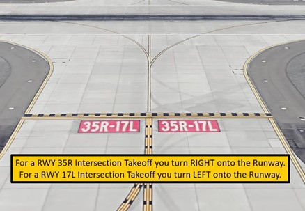
- The possibility exists for an intersection departure in the wrong direction. (See example below)
Wrong Surface Landing See Arrival Alert Notices.
- Higher terrain may obstruct the view of the landing RWY.
- Aircraft assigned to land on RWY 35R and starting base turn early, due to surrounding terrain, may line up on the more dominant RWY 35L.
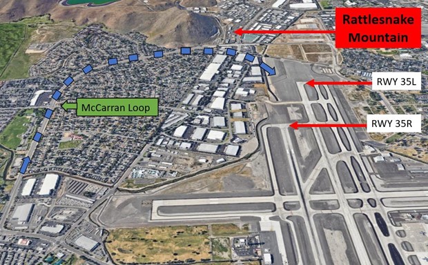
- Some pilots use the McCarran Loop east of RNO as a reference for the right downwind and base leg when landing north. Use caution if cleared to land on RWY 35R because this road could cause you to line up on dominant RWY 35L. (See illustration above.)
- Terrain makes it difficult for TWR controllers to verify aircraft are aligned with their assigned RWY. To assist pilots, TWR will illuminate the Runway End Identifier Lights (REILS) on RWY 35R when that RWY is in use.
Surface Risk – Movement Area Cautions
- The intersection of TWYs C and L, just N of RWY 08/26, warrants extra caution. Aircraft taxiing outbound from the FBO ramp have crossed the appropriate RWY Hold Short Markings without authorization.
Additional Cautions
- TWY C, between TWY L and TWY D, is 35 feet wide and not authorized for air carrier type aircraft or aircraft weighing more than 100,000 pounds.
- RWY 17R/35L have displaced thresholds.
- Noise sensitive area all quadrants. Avoid as much as feasible flying over-populated areas.
- Extensive glider activity in the vicinity of RNO and surrounding areas up to 18000´.
- Waterfowl all quadrants all seasons. Concentrated NW of RWY 17R and East of RWY 17L.
- Caution – Mountain wave wind conditions possible.
Weather
- RNO’s location downwind of Sierra Nevada Mountain range often results in challenging weather conditions. Sporadic extreme winds, windshear, severe turbulence, mountain obscurations, and high-density altitude routinely effect airport operations. Gains and losses of airspeed ranging from 10-30kts are not uncommon.
Traffic Patterns
- RNO’s calm wind runway configuration is southbound on RWYs 17R/L.
- RWY 08/26 is only activated when wind or operational necessity dictates.
- VFR single-engine traffic pattern altitude: 800ft AGL (5215ft MSL)
- VFR multi-engine/turboprop/jet traffic pattern altitude: 1000ft AGL (5415ft MSL)
- RNO often uses a single runway operation (due to runway maintenance). VFR aircraft can expect potential delays in this configuration.
Runway Crossings
- When RWY 08/26 is active, expect a higher volume of runway crossings.
- Aircraft exceeding taxiway C limitations parked at Atlantic can expect to cross the parallel runways and taxi via TWY A or TWY B.
- Aircraft parking on the east or west side of the field may have to cross the parallel RWYs.
Takeoff/Departure
- Closely spaced parallel runways and the mix of aircraft types can result in wake turbulence delays.
Arrival/Landing
- High mountainous terrain results in complex instrument arrival procedures with steeper-than-standard glideslopes.
- Closely spaced parallel runways and mix of aircraft type can result in wake turbulence encounters. Smaller aircraft should be aware of wake turbulence and be prepared to maintain visual separation or expect wake turbulence delays.
Avoidance Areas
- Rattlesnake Peak: 1.5nm SSE RNO 5000ft. Terrain near the airport. Pilots advised to use caution in base/crosswind turn.
Special Traffic (Military / Commercial / Helicopter, etc.)
- Expect a complex mix of airline operations, general aviation/corporate aircraft, flight schools (touch and go’s), Nevada Air National Guard (C-130s), medevac fixed- wing/helicopter, heavy cargo operators, etc.
- Increased traffic during the Burning Man week-long event.
Additional Information
- Snow removal operations during cold weather.