
Fernando Luis Ribas Dominicci Airport (SIG) (TJIG)
Fernando Luis Ribas Dominicci Airport (SIG) (TJIG), also known as Isla Grande Airport, is a busy, small general aviation airport located less than six miles west of the larger, commercial San Juan/ Luis Munoz Marin International Airport (SJU/ TJSJ). It is situated on the San Juan Bay just north of the city of San Juan, Puerto Rico. Primarily used by general aviation aircraft, SIG/TJIG also supports air-taxi, and military helicopter operations. There are six flight schools located on the airfield. Commercial aircraft arriving/departing SJU/TJSJ operate in adjacent airspace making the local area fleet mix very diverse. View a printable Pilot Handbook of the SIG information found on this Web page.
TWR Hours: 0700L-1900L
TWR Administrative Office: 0645L to 1445L M-F
TWR Business Phone: 787-723-0072
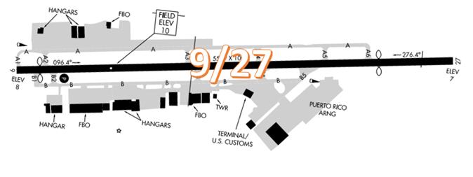
The airport configuration consists of a single RWY designated RWY 9/27. FBOs ramps, services and facilities are located on both sides of the RWY.
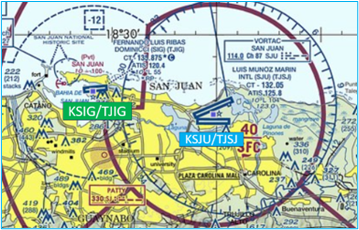
The airspace at SIG/TJIG is Class D and underlies San Juan Class C airspace. (Refer to Sectional Chart.)
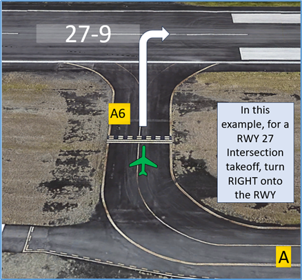
Wrong Direction Intersection Takeoff
- At SIG/TJIG, or at any airport where intersection take-offs are utilized, there is the risk that pilots may turn in the wrong direction when entering the RWY.
- Departures may be authorized RWY 9/27 intersection departure at TWY A6 upon request.
- Prior to entering the RWY and again when lining up on the RWY, check your Magnetic Compass and, your Horizontal Situation Indicator (HSI), if installed, to verify that you are pointed in the correct direction.
- View the From the Flight Deck-Wrong Direction Intersection Takeoffs video for more information and mitigation strategies.
Wrong Airport Landing Risk
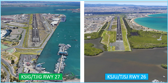
- There is the potential to line up with the wrong airport. Luis Munoz Marin International Airport lies less than 6 miles east of SIG/TJIG. Even though the RWY configuration is different, SJU/TJSJ RWY 8/26 could be mistaken for RWY 9/27 at SIG/TJIG.
- During pre-flight planning, check the sectional chart for airports in close proximity and charted reporting points.
- Use the most precise navigational aids available such as GPS, localizers, or VOR radials to positively identify the airport.
- If you're talking to ATC and you're unsure, ask the controller.
- View the From the Flight Deck-Wrong Airport Landings video for more information and mitigation strategies.
General
- SIG/TJIG is a compact airfield that requires continuous situational awareness of self and others both on the ground and in the pattern.
Traffic Patterns
- RWY 9 is left traffic at 1000 feet for fixed wing and right traffic for RWY 27 at 1000 feet.
- Helicopter traffic for RWY 9 is 500 feet to the right/left and RWY 27 its 500 feet to the right/left.
Ground Control (GC)
- GC frequency is 121.7. All ground surfaces are visible from the tower. TWY A between TWYs A4 and A6 is restricted from aircraft with a wingspan greater than 49 feet.
- There is a run up area located just north of the TWY A1 intersection. All aircraft must request authorization by ATCT prior to taxiing onto or off of the movement area.
Takeoff/Departure
- SIG/TJIG does not utilize Line Up and Wait (LUAW).
- Departing RWY 9: left traffic for VFR fixed wing aircraft continuing to the west and to remain outside class Charlie airspace at or below 1,000 feet until reaching the Dorado River. Aircraft that continue eastbound shall be on the Low Offshore Transition or the Sunny transition and given a squawk by ground control.
- Departing RWY 27: straight out departure to the west at or below 1,000 feet until reaching the Dorado River. Aircraft going eastbound into class the Class C airspace make right traffic, Low Offshore or Echo Transition eastbound and are given a squawk by GC.
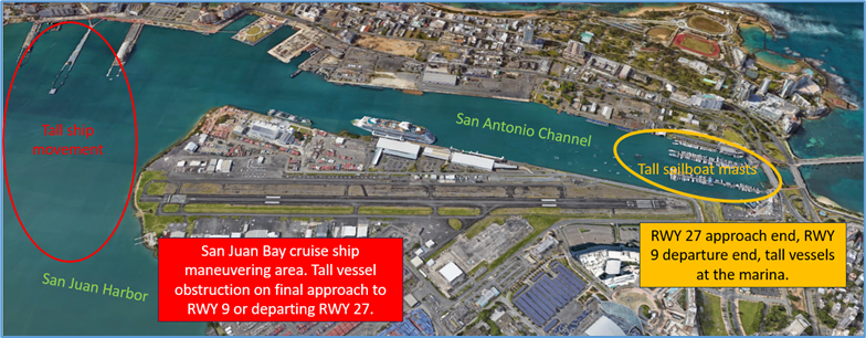
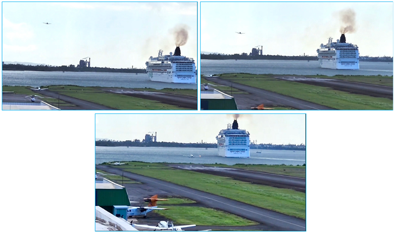
Tall Vessels in the Harbor/Channel
- Aircraft arriving RWY 9 or departing RWY 27, use caution for the ships transitioning the harbor, large ships include, but are not limited to, tall cruise ships, cargo ships and sail boats.
- Aircraft arriving RWY 27 and departing RWY 9, use caution for possible tall boat masts on vessels docked/anchored near the RWY 27 approach end.
Dorado VFR Practice Area
- The Dorado VFR Practice Area is located in an area where high performance jet traffic may be descending into San Juan International Airport. This potential safety risk requires the need for increased awareness on the part of the participants due to the high volume of jet traffic in and around the VFR Practice Area.
- Pilots are encouraged to review NOTAMs for the Letter to Airmen: LTA-SIG-7 “Dorado VFR Practice Area” for specific information and graphics.
Weather
- Strong winds, heavy rain and hurricane conditions are typical.
- Check for tower hours and service levels during inclement weather.