Salina Regional Airport (SLN)
Salina Regional Airport (SLN) is southwest of the city of Salina, KS., has passenger air carrier service but is primarily used by general aviation. Kansas State University Salina Aerospace and Technology Campus (a branch of Kansas State University) uses SLN as its base for flight training. There is a National Guard unit located both north and south of the TWR. View a printable Pilot Handbook of the SLN information found on this Web page.
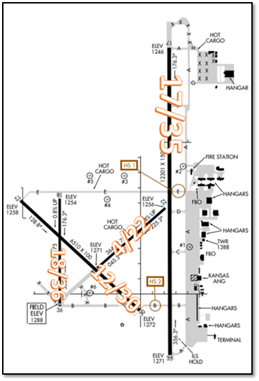
- The airport configuration consists of four (4) RWYs. RWYs 18/36 and 17/35 are parallel with staggered thresholds.
- The TWY system provides access to all ramps, services, and facilities.
TWR Hours: 0700L-2300L
TWR Administrative Office:
0900L to 1700L - M through F
TWR Business Phone: 765-825-4806
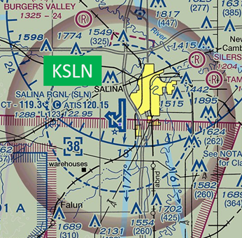
The airspace at SLN is Class D. (Refer to Sectional Chart.)
Hot Spots
HS 1: Traffic landing RWY 12 use caution when exiting onto TWY B. Hold line for RWY 17/35 approaches quickly. Note the elevated guard lights located on the west side of RWY 17/35 on TWY B.
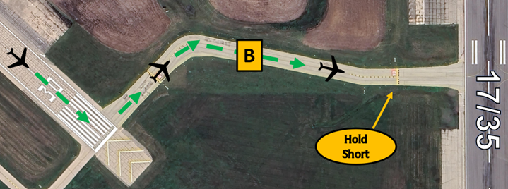
- The RWY Hold Short Markings for RWY 17/35 on TWY B are located after the bend in the TWY and pilots sometimes cross the hold short line resulting in a RWY incursion.
- If you are ever unsure of your clearance or position, ask the TWR.
- View the From the Flight Deck – Complex Airfield Geometry#7: Hold Short Lines In Unexpected Places for additional information.
Wrong Direction Intersection Takeoff
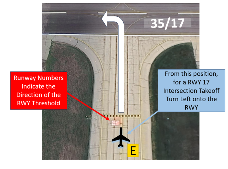
- At SLN, or at any airport where intersection take-offs are authorized, there is the risk that pilots will turn in the wrong direction when entering the RWY.
- Prior to entering the RWY and again when lining up on the RWY, CHECK YOUR MAGNETIC COMPASS and HORIZONTAL SITUATION INDICATOR (HSI), if installed, to verify that you are pointed in the correct direction.
- View the From the Flight Deck-Wrong Direction Intersection Takeoffs.
Wrong Surface Landings
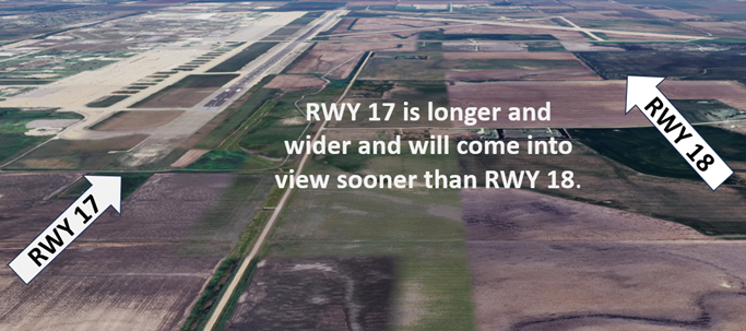
- The risk exists for a pilot to land or line up on the wrong RWY at airports with parallel RWYs.
- SLN RWYs 18/36 and 17/35 are parallel with staggered thresholds. This increases the risk for pilots to line up on the closest or the RWY that appears first.
- View From the Flight Deck – Wrong Surface Landings for additional mitigation strategies.
Additional Cautions
- No line of sight, all RWYs due to gradient, topography, and trees.
- Seasonal mowing operations adjacent to RWYs and TWYs.
- Calm wind RWY is RWY 35.
- RWY 4/22 and RWY 18/36 are unavailable for use by aircraft with more than 9 passenger seats.
- Self-service fueling station located south of Kansas ANG.
General
- We are a VFR ATCT with the overlying radar services provided by ZKC (Kansas City Center). SLN ATCT utilizes a radar display with feeds from Fort Riley, Hutchinson, and Wichita (due to the distance of these radar system aircraft inside northwest portion of the class delta may not be seen on this display).
- If one of these systems is unavailable, pilots may be given more reporting points for sequencing purposes. Due to the large number of student pilots that work in and out of SLN airspace, tours of the ATCT are encouraged and can be accommodated when approved by the Air Traffic Manager.
Traffic Patterns
- Standard traffic patterns for RWY 17/35 are to the east over the city of Salina during the day and west of RWY 17/35 at night. (RWY 17/35 and RWY 12/30 are the only RWYs used for night operations).
- Smaller aircraft can expect RWY 18/36 when conducting multiple touch-and-go operations.
- Pattern altitude is 2300MSL for GA Aircraft, 2800MSL for Heavy and Jet traffic.
- Standard Overhead initial altitude is 3200MSL (Initial point will be assigned by the tower).
Ground Control
- Ground Control and Clearance Delivery are normally combined on one frequency. This may result in multiple aircraft calling one controller that is working two frequencies. Pilots may hear a controller making a transmission without a response from the aircraft on the other frequency. Be patient and listen for your call sign.
- For aircraft requesting VFR departure out of SLN Class Delta, controllers prefer you tell tower your direction of flight on initial contact. This helps the tower to more efficiently manage the volume of traffic that moves in and out of the KSU ramp.
- Be aware of and use caution for possible jet blast when taxiing in the vicinity of the South Ramp. Air carriers utilize this ramp area.
Takeoff/Departure
- Student pilots that need a momentary pause on the RWY prior to starting takeoff roll should make this request on initial contact. For planning and sequencing purposes, if a momentary pause is requested after a take of clearance has been issued this request may be denied due to arriving traffic.
Arrival/Landing
- With RWY 17/35 being over 12000 feet, pilots may request to land long on RWY 17/35. This helps to facilitate shorter taxis for aircraft exiting the RWY for the FBO and T hangar parking.
Weather
- During winter snow removal operations, RWY 17/35 and TWYs A/E east of RWY 17/35 will be cleared of snow first. The airport will clear all other TWYs and then the west side of the airport after the snowfall has ended. Always check NOTAMs for RWY and TWY closures.
Additional Information
- SLN hosts multiple large events every year from military training to the IAC National Aerobatic Championships. During these events pilot training and the ability to accommodate may be affected due to launch and recovery during this event.
- Due to the proximity of the Smoky Hill range Complex (R3601), SLN tower monitors if it’s active or not. Pilots may contact SLN tower to confirm the status of the range to avoid flying through it when it is active.
