St Paul Downtown Airport Holman Field (STP)
St Paul Downtown Airport Holman Field (STP) is located just across the Mississippi River from downtown Saint Paul, Minnesota. It is one of several reliever airports in the Twin Cities operated by the Metropolitan Airports Commission. The airport has three runways and serves aircraft operated by corporations in the local area, a flight training school and the Minnesota Army National Guard aviation unit, as well as transient general aviation aircraft. View a printable Pilot Handbook of the STP information found on this Web page.
STP Tower Hours of Operation: 0600L-2200L M-F/0700L-2200L S-S
Administrative Office: Open 0630L to 1500L M-F
Business Phone: 651-312-8840
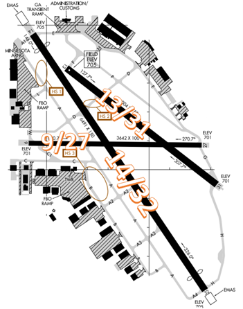
The airport configuration consists of intersecting RWYs 9/27, 13/31 and 14/32.
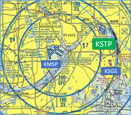
The airspace at STP is Class D and underlies Minneapolis Class B. (Refer to Sectional
Chart)
Hot Spots
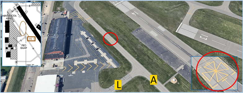
HS 1: Helicopter landings on TWY A.
- The National Guard operates helicopters at STP which does not have a helipad and utilizes areas of TWYs for landings.
- Pilots operating on TWYs A/L or pilots on the ramp need to be aware of and listen for ATC instructions when helicopter operations are occurring.
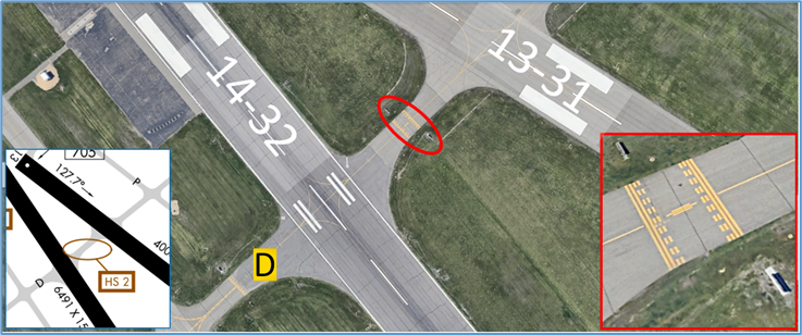
HS 2: Unusual placement of RWY holding position markings due to overlapping RWY Safety Areas. Short distance between RWYs, manage your taxi speed and be prepared to hold short when exiting RWY.
- The segment of TWY D Between RWYs 13/31 and 14/32 has a very short distance to the RWY Holding position markings/signage from both directions on the TWY.
- Pilots exiting either RWY or taxiing via TWY D need to be aware of the Hold Short line placement and be prepared to stop at the appropriate point when issued hold short instructions.
- Actively scanning to locate and identify RWY signs, markings, and lighting and deferring all heads down activities until holding short at the appropriate location will help eliminate these errors.
- If you are unsure of your instructions or your position, ask the TWR.
- For additional mitigation strategies, pilots should review the From the Flight Deck-Hold Short video.
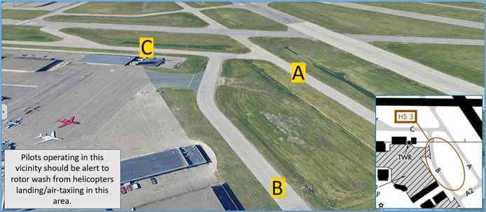
HS 3: Helicopter operations on TWY B.
Surface Movement Area Cautions
- RWY 14 threshold displaced 343’. RWY 32 threshold displaced 382’. The RWY overruns with the yellow chevrons are not available for taxiing.
- EMAS is located at the approach ends of RWY 14/32.
Wrong Surface Landing Risks
- Pilots sometimes confuse RWY 31 and RWY 32.
- The alignment of RWYs 31 and 32 has led to aircraft lining up for the wrong runway. STP primarily uses RWY 14/32 while RWYs 13/31 and 9/27, see limited use. In most instances of misalignment, arrival aircraft will line up for RWY 31 instead of the intended RWY 32. This seems to be much more likely to happen at night or during low/restricted visibility and when runway lights are in use.
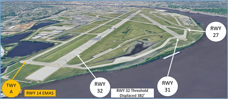
- RWY 32 is over one-third longer with a 382’ displaced threshold and has precision approach markings for the ILS/DME approaches. An additional distinguishing feature is RWY 14 EMAS located at the approach end of RWY 32.
- RWY 32 does not have approach lights like the reciprocal RWY 14 MALSRS. It only has Runway End Identifier Lights (REILs) just like RWY 31. On approach at night with little to distinguish the two RWYs apart (other than compass alignment or backing up visual approach with a RWY 32 instrument approach), the similar lighting can make it difficult to align with the proper RWY.
- RWYs 13/31 and 9/27 have 3 step lights while RWY 14/32 has 5 step lights. When all runway lights are on low intensity, RWY 14/32 looks much dimmer than RWYs 9/27 and 13/31. This may cause pilots to mistakenly align to the brighter RWY 31 because RWY 32 doesn’t stand out against the other runways. To assist pilots with runway identification, controllers sometimes adjust RWY 14/32 lighting to a higher setting.
- When available, back up all visual approaches with an instrument approach/GPS waypoint to help ensure that you are lined up for the correct surface.
- RWY markings are white. Markings on surfaces not used for takeoff/landing like TWY markings, chevrons, RWY shoulder and RWY turn-on markings etc., are yellow.
- View the From the Flight Deck-Wrong Surface Landings video for additional mitigation strategies.
Wrong Airport Alignment Risk
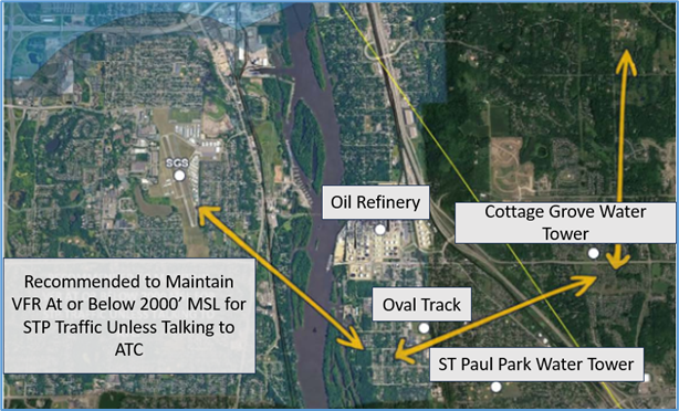
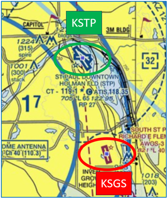
- Pilots approaching from the south landing RWY 32 have lined up for and/or attempted to land SGS RWY 34 which is located five miles SSE of STP.
- During pre-flight planning, check the sectional chart for airports in close proximity and charted reporting points.
- Use navigational aids such as GPS, localizers, or VOR radials to positively identify the airport.
- View the From the Flight Deck-Wrong Airport Landings video for more information and mitigation strategies.
Arrival/Landing
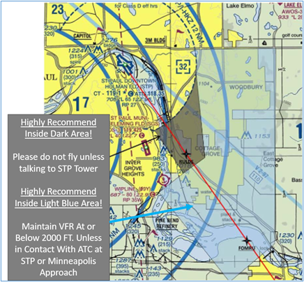
- Aircraft on ILS approach to STP RWY 32 often conflict with SGS traffic departing RWY 34 or landing RWY16 inbound from the east. TWR may not be in communication with these aircraft.
The following information can be found in NOTAMS- Letter to Airmen: LTA-STP-36.
SGS Airport is located 5 miles SSE of STP Airport. Due to the close proximity of the STP Runway 32 final approach course, SGS traffic should use extreme caution when arriving or departing from the East or Southeast. IFR traffic inbound to Runway 32 at STP normally maintains 2500 ft. MSL until approximately 7 miles from STP and then start a descent. Suggest contacting STP ATCT on 119.1 for traffic advisories.
