
Charles M. Schulz Sonoma County Airport (STS)
Charles M Schulz Sonoma County Airport (STS) provides service to aircraft with a wide range of performance capabilities. A mix of air carrier, corporate and general aviation aircraft are served by STS. It is located northwest of the city of Santa Rosa, California. During a wildfire season that lasts from late spring to early winter, STS will see intense periods of high traffic due to firefighting aircraft activity. View a printable Pilot Handbook of the STS information found on this Web page.
Know Before You Go
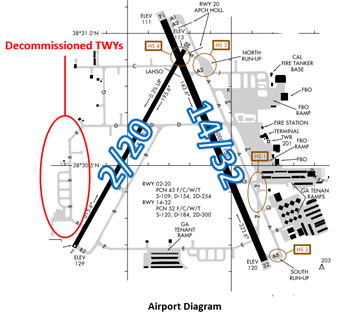
The airport configuration consists of intersecting RWYs 14/32 and 2/20. Most general aviation services are located on the eastside of the airfield.
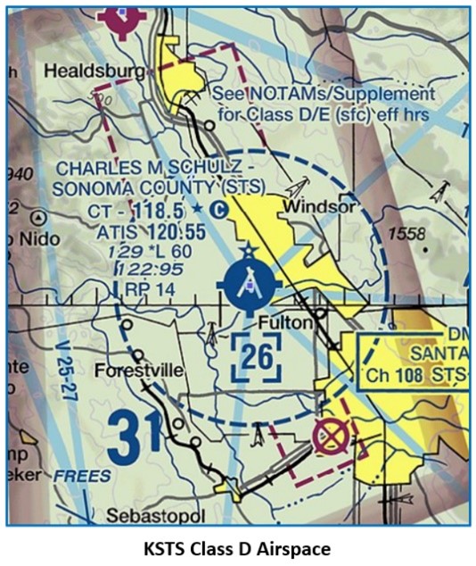
The airspace at STS is Class D. (Refer to the below Sectional Chart)
Below find various STS-specific information and things to be aware of, as well as general information to inform your preflight planning. This will be reviewed quarterly and updated as needed. This information is to supplement the From the Flight Deck Videos that are produced by the FAA Runway Safety Group. Here you will also find information provided by the local air traffic controllers at the airport where you intend to fly. The information is subject to change. Not for navigation or legal* pre-flight action. Always refer to official pre-flight materials such as, but not limited to, NOTAMs, airport diagrams, VFR charts and airport construction notices for the latest airport-specific details.
STS Tower Administrative Office
Business Phone: 707-546-4294
Open: 0930 to 1630 Local – Monday through Friday
Hot Spots
HS 1: Complex intersection in close proximity to RWY 14/32. Aircraft approaching TWY A from the ramp or TWY Z sometimes fail to turn onto TWY A and enter RWY 14/32 without approval.
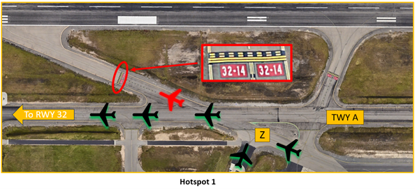
- When issued taxi instructions “RWY 32 taxi via TWYS zulu and alpha” from the ramp or southeast hangars, pilots need to ensure that they keep left and make the turn onto TWY A.
- Pilots need to be aware of their position and clearance to avoid taxiing onto RWY 14/32.
- TWR has limited visibility of T-Hangar aprons east of TWY Z and adjacent to TWY A5.
- If you are ever unsure of your instructions or position, ask the TWR.
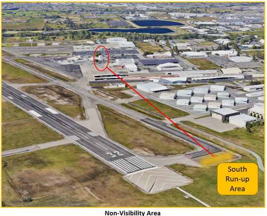
HS 2: South Run–up area not visible from the TWR.
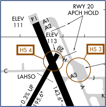
HS 3: North Run–up area east of TWY A and TWY H intersection in close proximity of RWY 20 Approach Hold sometimes confuses pilots.
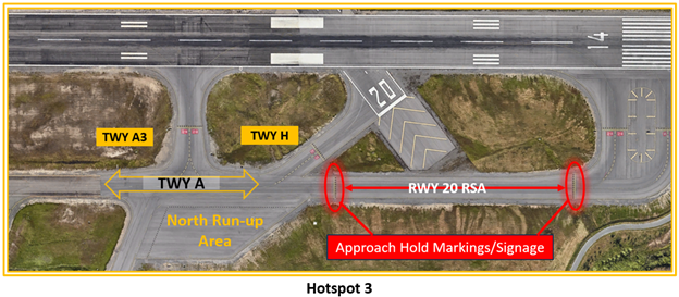
A unique feature of the airport is that small piston aircraft are taxied with a clearance limit of the North run-up area and not the departure RWY.
- Clearance must be obtained prior to leaving the run-up area for RWY assignment.
- TWR will normally issue RWY 20 full length at TWY H, or RWY 14 at TWY A3.
- The RWY 20 approach hold line is on TWY A. Aircraft that are taxied to RWY 14 may receive control instructions to hold short of RWY 20 Approach.
- Aircraft that are taxied from the North Run-up Pad to RWY 20 via TWY H sometimes make a slight right turn and end up crossing the RWY 20 Approach Hold Line.
- Pilots have missed the run-up area completely and continued to taxi on TWY A across the RWY 20 Approach Hold Line.
- Non-compliance with taxi instructions has resulted in arrivals executing a “go-around” on RWY 20 for taxiing aircraft.
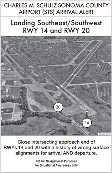
HS 4: Wrong RWY departure risk. Pilots cleared for takeoff RWY 20 sometimes turn onto and depart RWY 14. Verify heading and alignment with proper RWY prior to departing. See Arrival Alert Notice.
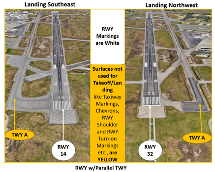
Wrong Surface RWY Landing Risk
- Whenever a TWY runs parallel to a RWY, the risk of a TWY landing increases.
- At STS, TWY A is a full length parallel TWY to RWY 14/32.
- If available, back up all visual approaches with an instrument approach to help ensure that you are lined up with the correct RWY.
General
- Santa Rosa Valley has a southeast to northwest alignment so use caution when reporting inbound from the south or north, you may be southeast or northwest and that makes a difference in pattern entry.
- Read back all RWY, Run-Up Area assignments, and Hold Short instructions.
Traffic Pattern
- Pilots remaining in the pattern can expect to continue in closed traffic on the west side of the airport, i.e. Right Traffic RWY 14.
Ground
- There is no restaurant/transient parking so expect taxi instructions to one of the FBO’s.
Takeoff/Departure
- When finished with your run up in the North Run-Up Area, hold your position and contact TWR on 118.5 for a RWY assignment.
- From the North Run-Up Area expect to depart from RWY 14 at TWY A3 or if assigned, RWY 20 from TWY H. Both are adjacent to the North Run-Up Area.
Arrival/Landing
- When arriving from the east or south when in a RWY 14 configuration, controllers will assign left or right traffic with the expectation that pilots will enter on a 45-degree intercept to remain clear of the RWY 14 departure corridor.
- Use caution when extended on the left downwind to RWY 14. The valley tapers to the northwest and leads pilots into the final approach corridor for RWY 14.
Special Traffic (Military / Commercial / Helicopter, etc.)
- Helicopter traffic that wishes to remain in the pattern can expect closed traffic to RWY 20 and instructions to “remain west of RWY 14/32 at all times”.
Additional Information
- Use caution for both seasonal and year around bird activity.
- Coyotes and deer frequent the airdrome, use caution for wildlife activity.