Tulsa International Airport (TUL)
Tulsa International Airport (TUL) is a medium sized multi-use airport, located on the northeastern edge of Tulsa, Oklahoma. It serves air carrier, air cargo, business, and general aviation, as well as locally based and itinerant military aircraft. TUL is home to the 138th Fighter Wing and OK Army Guard. View a printable Pilot Handbook of the TUL information found on this Web page.
Know Before You Go
TUL Tower Hours of Operation Continuous-24/7
Administrative Office Open 0700L to 1500L M-F
Business Phone 918-831-6700
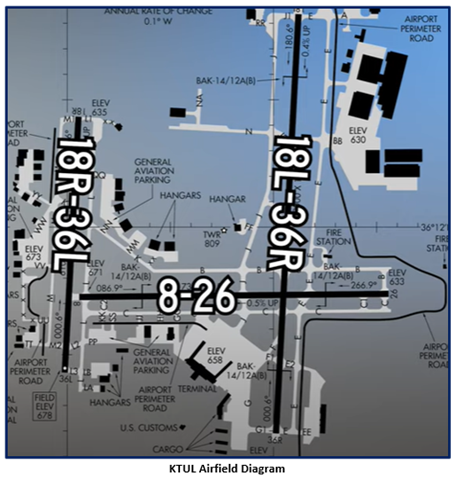
The RWY configuration consists of parallel RWYs 18L/R and 36L/R with intersecting RWY 8/26 which crosses the larger RWY 18L/36R but not the shorter RWY 18R/36L.
The airspace at TUL is Class C. (Refer to Sectional Chart.)
Below find various TUL-specific information and things to be aware of, as well as general information to inform your preflight planning. This will be reviewed quarterly and updated as needed. This information is to supplement the From the Flight Deck Videos that are produced by the FAA Runway Safety Group. Here you will also find information provided by the local air traffic controllers at the airport where you intend to fly. The information is subject to change. Not for navigation or legal* pre-flight action. Always refer to official pre-flight materials such as, but not limited to, NOTAMs, airport diagrams, VFR charts and airport construction notices for the latest airport-specific details.
Hot Spots
There are no Hotspots.
Wrong Surface Landings
- Wrong Surface Landing risk exists with offset parallel RWY’s with staggered thresholds.
- RWY 18L is longer than and comes into view before the shorter RWY 18R. This is also the case with RWY 36R and the shorter RWY 36L.
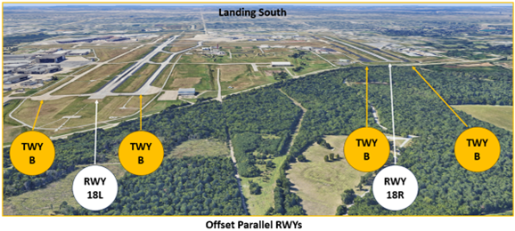
- A Wrong Surface Landing risk exists whenever a TWY parallels the RWY.
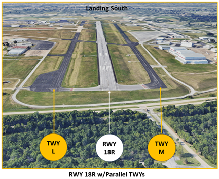
- Pilots have mistakenly lined up on final for TWY M mistaking it for RWY 18R.
- Positive identification of the RWY needs to be a part of every takeoff and landing checklist.
- Runway Markings are White. Surfaces not used for Takeoff/Landing like Taxiway Markings, Chevrons, Runway Shoulder, and Runway Turn-on Markings, etc., are Yellow.
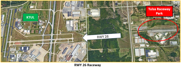
- A Wrong Surface Landing risk also exists at TUL when landing west. A drag racing strip near the airport and on final for RWY 26, has the same orientation and may be confusing. This risk can be more pronounced during sunset.
- For all these Wrong Surface Landing Risks, loading an instrument approach to the assigned RWY will help pilots ensure they are landing on the proper surface.
Additional Cautions
- A perimeter road with markings and signage circles most of the airport.
- A large, wooded area north of the airport contributes to increased bird activity in the vicinity of the airport.
- Several uncontrolled airports are located underneath the outer ring of the Class C airspace. Be alert for pop-up VFR aircraft.
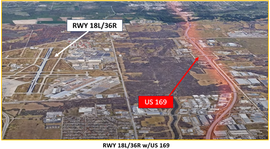
- Do not confuse the multi-lane highway, US 169 which parallels RWY 18L/36R, for a RWY.
Traffic Patterns
- We primarily utilize RWY 18R/36L for aircraft in the traffic pattern. Pattern altitude is at or below 2500’ MSL.
Ground Control
- Let us know where you are parked and ready to taxi with current ATIS.
- All FBO parking and the terminal ramp areas are uncontrolled.
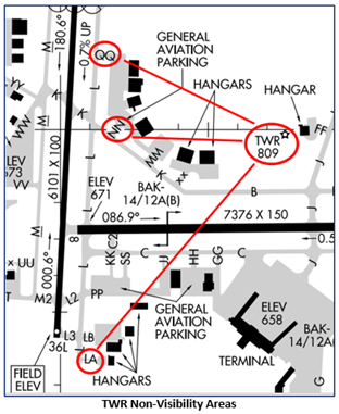
- The following areas are not visible from the ATCT:
- Taxilanes (TXLs) LA, NN and QQ. (See illustration.)
- When exiting the TXLs, hold short of the TWY and contact Ground Control for instructions.
Runway Crossings
- Read back RWY crossing/hold short instructions with callsign in the same transmission.
Takeoff/Departure
- IFR departures will be issued RWY heading or a turn 50 degrees left or right depending on destination.
- TWR will try to issue VFR departures a turn toward their destination.
Avoidance Areas
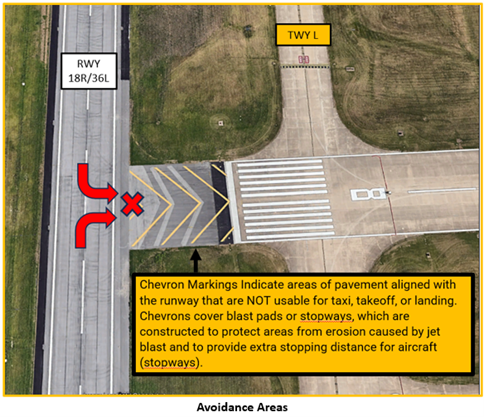
- When landing on RWY 18R/36L DO NOT exit onto RWY 8/26. Even though the pavement at the approach end of RWY 8 connects to RWY 18R/36L, that area is a protected area and NOT USABLE FOR TAXI, TAKEOFF, OR LANDING.
Arrival/Landing
- TUL Approach will sequence all IFR/VFR inbound traffic.
- When in the traffic pattern, the TWR will extend upwind/downwind as necessary.
- Pilots are expected to exit the RWY at the first available TWY unless a specific TWY is issued.
Weather
- The weather can change rapidly. There may barely be any wind and then 50kt gusts may occur.
Special Traffic (Military / Commercial / Helicopter, etc.)
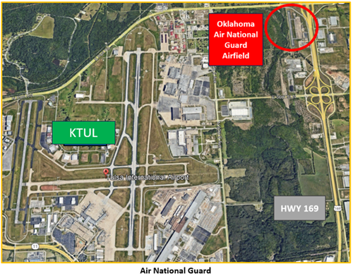
- TUL is home to the 138th Fighter Wing, located on the north end of TWY E.
- TUL TWR also coordinates low-level helicopter operations, for the Oklahoma Army National Guard Unit, located about 1.25 NM northeast of the field. (See illustration below.)