Tucson International Airport (TUS)
Tucson (TUS) Long-Term Airfield Changes
Effective November 30, 2023, TUS closed RWY 11R/29L
permanently (not depicted on airfield diagram) and began construction of a new south parallel RWY and center TWY. Work is expected to take approximately 2 years, with the new runway anticipated to open in 2026. RWY numbers have been updated to reflect the current magnetic declination. See FAA Airport Diagrams
Check the NOTAMs and listen to ATIS closely for closed surfaces and other pertinent operational information.
Resources
- Terminal Procedures Search (Enter TUS in the Search Bar)
- Search for the TUS Construction Notice Diagram and Letters to Airmen
- TUS Arrival Alert Notice
- FAA Safety Team Notice with additional information from TIAA on this major airport safety and improvement project
- Flyer on TUS Airport Construction
View a printable Pilot Handbook of the TUS information found on this Web page.
Know Before You Go
Due to long-term airfield changes, the From the Flight Deck (FTFD) video has been removed. In the future, a FTFD video will again be available which depicts actual TUS airport runway approach and taxiway footage combined with diagrams and visual graphics to clearly identify hot spots and other safety-sensitive items.
Tucson International Airport (TUS) is a civil-military airport, located 8 miles south of downtown Tucson, AZ.
TUS Tower Hours of Operation – Continuous 24/7
Administrative Office Open 0800L to 1600L – M through F
Business Phone 520-295-5722
Effective November 30, 2023, TUS closed RWY 12/30 permanently (not depicted on airfield diagram) and began construction of a new south parallel RWY and center TWY. Work is expected to take approximately 2 years, with the new runway anticipated to open in 2026. RWY numbers have been updated to reflect the current magnetic declination. See FAA Airport Diagrams
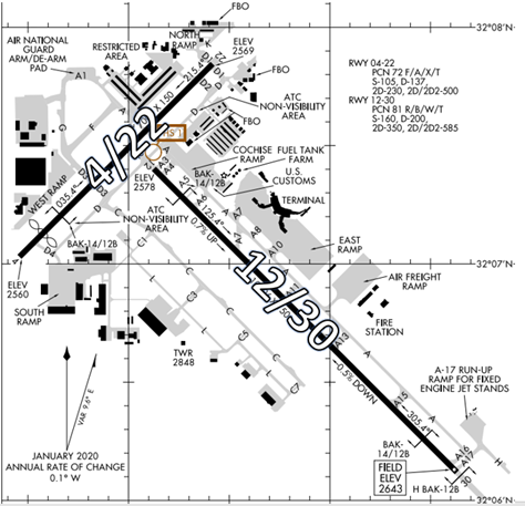
TUS has changed the signs and markings on the airfield to denote the new numbering. Throughout construction you are advised to check the NOTAMs and listen to ATIS closely for closed surfaces and other pertinent operational information. All the approaches will be updated to reflect the new numbering. Also look for possible Letters to Airmen posted on FAA’s NOTAM Search site that may provide additional operational information and cautions. NOTAM Search (faa.gov)
Local and transient general aviation aircraft make up almost 50% of the traffic mix. Additionally, commercial, military and air taxi operations add to the challenging complexity at TUS.
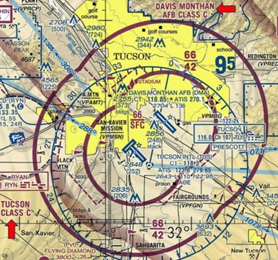
The airspace at TUS is Class C. Notice that it adjoins Davis Monthan AFB Class C Airspace. (Refer to Sectional Chart.)
Hot Spots
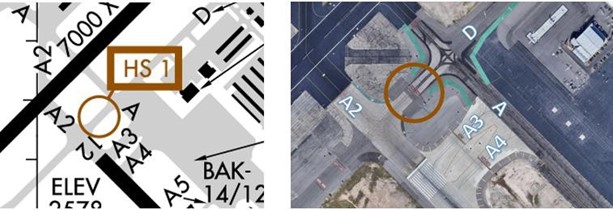
- HS 1 Pilots taxiing to RWY 12 via TWY D for departure sometimes cross the RWY Holding Position markings without authorization. Reference Airport Diagram.
Wrong Surface Intersection Takeoff
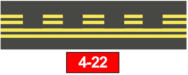
The risk exists for a Wrong Surface Intersection Takeoff. Using the above example -
- If cleared for a RWY 4 Intersection Takeoff, turn RIGHT onto the RWY.
- If cleared for a RWY 22 Intersection Takeoff, turn LEFT onto the RWY.
- CHECK YOUR MAGNETIC COMPASS/HORIZONTAL SITUATION INDICATOR (HSI).
Wrong Surface Taxiway Landing
See Arrival Alert Notices (AAN).
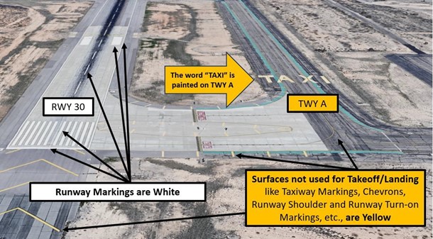
At TUS, with full-length TWYs that parallel the RWY, the risk exists for a Wrong Surface TWY Takeoff. RWY Markings are White. TWY Markings are Yellow.
Surface Risk – Movement Area Cautions
- Portions of TWY D are not visible from the TWR as indicated on the Airfield Diagram.
- Markings and signs have changed due to the RWY number changes.
- Construction on the airport.
Special Traffic (Military / Commercial / Helicopter, etc.)
- The 162nd Fighter Wing of the Arizona National Guard (ANG) calls TUS home. The largest ANG unit in the country, it trains US pilots and many of her allies. Typically flying 60 to 70 flights a day, it is not uncommon to see 8 to 10 F16’s in the pattern.
Additional Cautions
- Extensive Military Training Areas in all quadrants surrounding TUS.
- English may be the second language to some student pilots.
- GLIDER OPERATIONS - There is regularly scheduled glider/soaring activity conducted from El Tiro Gliderport, which is located approximately on the Tucson VORTAC 297º radial at 31 nautical miles. Much of the soaring conducted near the intersection of V66 and V105 are at altitudes up to, but not including flight level 180.
- Extensive Sky Diving activity – See Sectional Chart
- Mountainous terrain.
General
- TUS is currently under heavy construction.
- Due to airport construction, the only TWYs available to/from the RWYS and FBOs are TWY D and TWY A. Expect potentially long wait times for taxi due to opposite direction traffic on these TWYs during busy operations.
Traffic Patterns
- RWY 12
- Smaller GA aircraft - right traffic – 800’ AFE
- Military and larger aircraft - left traffic – 1400’ AFE
- RWY 30
- Smaller GA aircraft – left traffic – 800’ AFE
- Military and larger aircraft – right traffic - 1400’ AFE
Weather
- High wind gusts possible and crosswinds are prevalent during the Monsoon Season (Jun-Sep).
Runway Crossings
- During the current phase of construction, aircraft parking at the North Ramp or the Millionaire FBO, can expect to cross RWY 4/22 at TWY D1.
Takeoff/Departure
- TWY D has no specified run-up area. Controllers expect you to pull up to RWY 12 @ TWY D and RWY 30 @ TWY A13 (or assigned intersection from Ground Control (GC), perform your run-up there and advise TWR when ready for departure.
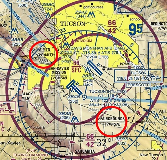
- There is no established Diverse Vector Area (DVA). Pilots can expect instructions to proceed on course or expect vectors outbound if not directed to proceed to “A” Mountain (VPAMT) or Fairgrounds (VPFGN). (See illustration below.)
Arrival/Landing
- Specific arrival frequencies are broadcast on the ATIS.
- Exiting the RWY as soon as it is safe to do so will greatly help with traffic flow.
- When landing RWY 4, smaller GA aircraft can expect to be issued a hold short instruction for TWY A2 or asked to expedite past this intersection to protect the Runway Safety Area for aircraft landing RWY 12/30. There are no hold bars located on the RWY for this instruction.
- When exiting a RWY, ensure that your entire aircraft is beyond the RWY Holding Position Marking prior to contacting GC.
- Small VFR aircraft inbound from the West/South may be instructed to “Proceed direct to the Mission, for a right base entry on RWY 12.”
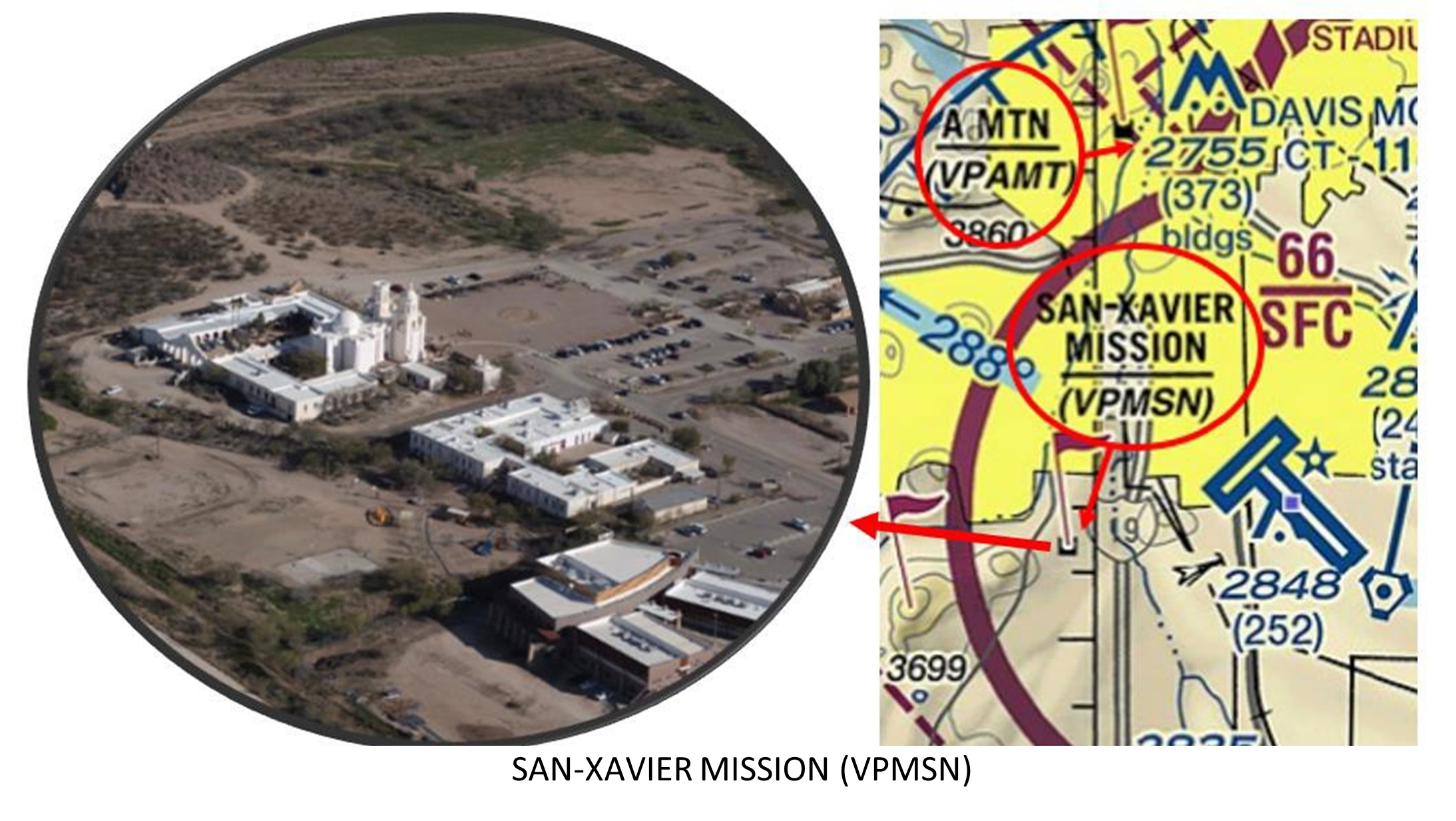
- Sometimes small VFR aircraft will be issued instructions to “Hold over the Mission” for sequencing during single RWY operations.
- It is difficult to identify or spot this point from the air. It is identifiable as a cluster of white buildings to the east of a small hill.
Wildlife
- Heavy coyote presence in the vicinity of RWYs and TWYs.
Wrong Airport Landing Potential
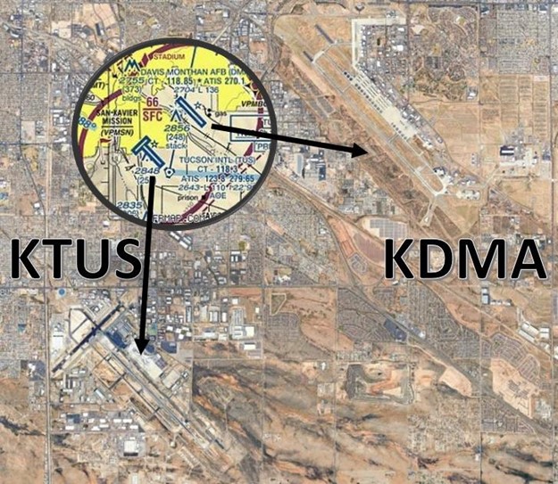
- A Wrong Airport Landing risk exists between Davis-Monthan AFB (DMA) and TUS, especially when landing on RWY 12/30 because both airports are located only 5NM apart with same RWY numbers.
- We also utilize same arrival/departure flows depending on wind direction.
