
Van Nuys Airport (VNY)
Van Nuys Airport (VNY) is a medium sized, primarily business, and general aviation airport located in the city of Van Nuys, California. It is situated six miles west of the Hollywood Burbank Airport (BUR), and 15 miles north of Los Angeles International Airport (LAX). The traffic mix consists if general aviation, air-taxi, military, and commercial operations, and multiple flight schools providing both fixed and rotor wing instruction. VNY is one of the busiest general aviation airports in the country and the wide variation of pilot experience, and aircraft capability makes this a very challenging airport. View a printable Pilot Handbook of the VNY information found on this Web page.
Know Before You Go
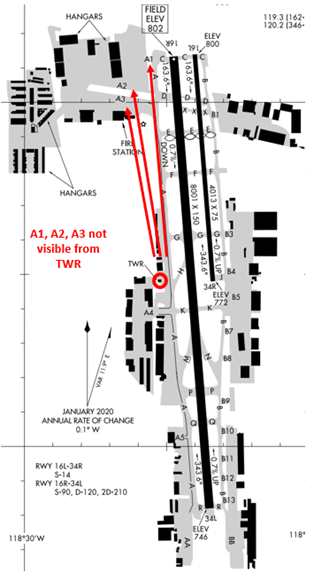
The airport configuration consists of closely spaced parallel RWY’s 16L/34R and 16R/34L.
The RWYS have staggered thresholds.
Taxilanes A1, A2 and A3 are not visible from the TWR.
Full-length parallel TWYS on either side of the RWYS .
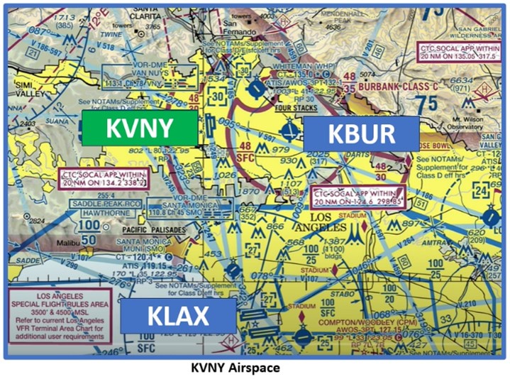
The airspace at VNY is Class D and underlies the Burbank Class C airspace. (Refer to Sectional Chart)
VNY Tower Hours of Operation 0600L-2245L
Administrative Office Open 0700L to 1530L M-F
Below find various VNY-specific information and things to be aware of, as well as general information to inform your preflight planning. This will be reviewed quarterly and updated as needed. This information is to supplement the From the Flight Deck Videos that are produced by the FAA Runway Safety Group. Here you will also find information provided by the local air traffic controllers at the airport where you intend to fly. The information is subject to change. Not for navigation or legal* pre-flight action. Always refer to official pre-flight materials such as, but not limited to, NOTAMs, airport diagrams, VFR charts and airport construction notices for the latest airport-specific details.
Hot Spots
- There are no Hotspots.
Wrong Surface RWY Landing
- Pilots sometimes confuse RWY 16L/R and RWY 34L/R. See Arrival Alert Notice.
- Loading an instrument approach will help pilots ensure that they are lined up with the correct RWY.
Wrong Surface Intersection Takeoff
- The risk exists for a wrong direction takeoff during an intersection departure.
- The most common intersection departures are RWY 16R at TWY D (distance remaining 7350’) and RWY 34L at TWY Q (distance remaining 6500’).
- Prior to entering the RWY and again when lining up on the RWY, check your Magnetic Compass and, your Horizontal Situation Indicator (HSI), if installed, to verify that you are pointed in the correct direction.
- All jet aircraft must use the full RWY length for departure unless otherwise directed by ATC.
- Recommend viewing From the Flight Deck – Wrong Direction Intersection Takeoffs.
Arrival
- Familiarity with VFR Reporting Points, found on the VFR Sectional Chart, will help TWR with traffic sequencing. Commonly used reporting points:
- Cal State Northridge,
- VA Hospital,
- Sepulveda Flood Basin,
- Northridge Mall.
- If you are not familiar, or cannot find these Reporting Points, advise TWR for alternate instructions.
Whiteman Airport (WHP) Traffic
- Located 4 miles NE of VNY.
- Aircraft departing WHP to the NE are not required to communicate with ATC if clear of WHP or VNY Class D airspace.
- Caution: This traffic may conflict with traffic inbound to VNY 16L/R arrivals.
Surface Risk – Movement Area Cautions
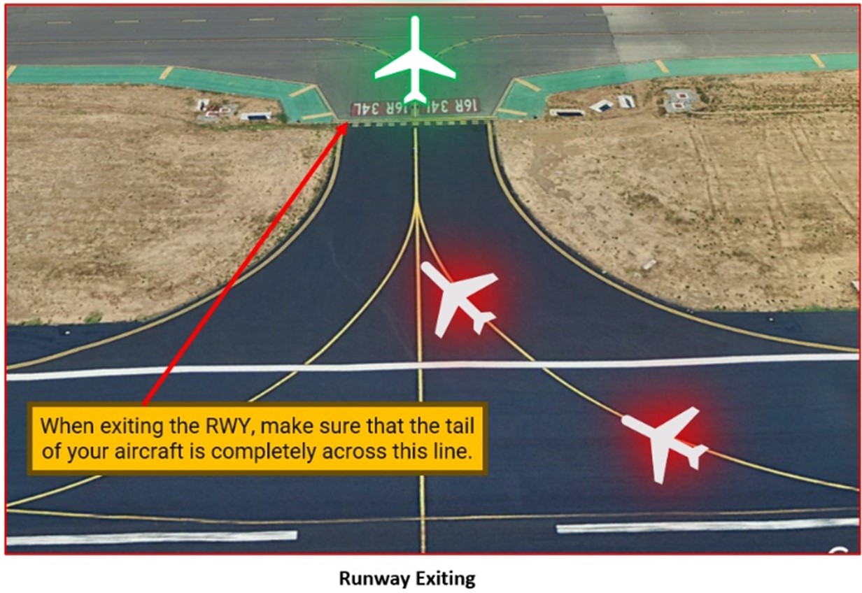
- When exiting the RWY, taxi without delay to cross the hold short line to clear the RWY behind you.
- Your aircraft is not clear until it is completely across this line.
- Delay in clearing the RWY can cause aircraft landing behind you to go-around.
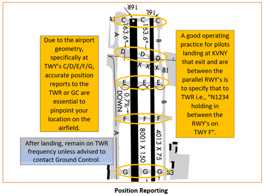
- TWY’s C/D/E/F/G all extend across the parallel RWY’s.
- Accurate position reports are essential when exiting a RWY after landing.
- Pay attention to the markings and signage as well as the controller’s instructions.
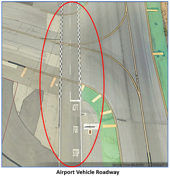 Pilots need to be aware of vehicles operating on the airport vehicle service road.
- Black and white zippered lines or solid white lines identify the roadway.
- Vehicles are instructed to give way to aircraft, but pilots should be aware of these vehicles and always maintain situational awareness while taxiing on the airport surface.
Additional Cautions
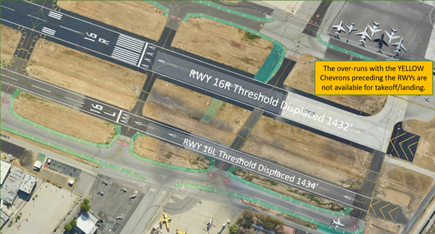
- RWY’s 16L/R both have displaced thresholds.
- The portion of RWY behind a displaced threshold is available for takeoffs in either direction or landings from the opposite direction.
- Bird abatement may occur between RWYS when TWR is open.
- RWY 16L/34R is closed and unlighted when TWR is closed.
- Helicopter contact TWR for approach/departure routes.
- Due to aircraft on BUR RWY 8 final receiving TCAS Resolution Advisories, please adhere to Traffic Pattern Altitude and climb gradients.
General
- The VNY airspace is heavily congested.
- Extreme noise sensitive area.
- Remain alert to traffic to the parallel RWY and ensure you do not overfly finals.
- There is no airport sponsored transient parking at VNY.
- Transient parking may be available at the FBO’s near the fuel pit. Contact the FBO in advance for availability and reservations.
Traffic Patterns
- When possible, pattern work will be conducted on RWY 16L/34R.
- Request all early turns and non-standard traffic patterns from the controller.
- VNY is an extremely busy VFR training airport. Be vigilant for student pilots.
- Ensure you remain over your departure runway and do not drift into the departure leg of the parallel RWY.
- Aircraft operating in the pattern at VNY should be extremely vigilant to maintain the correct altitude while operating in the VFR Traffic Pattern.
- Base to Final Turns need to be made to not cross the extended centerline for the assigned RWY. Overshooting final could result in a conflict with aircraft landing on the parallel RWY.
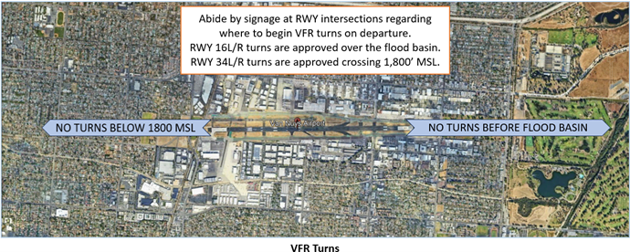
- East Traffic Pattern Altitude 1800 MSL.
- West Traffic Pattern Altitude 2000 MSL (VFR aircraft departing West of VNY up to 2500 MSL).
Runway Crossings
- Read back all hold short instructions with your callsign in the same transmission.
- Use caution not to inadvertently cross the parallel RWY after landing.
- After landing while holding short of the parallel RWY, remain on the TWR controller’s frequency unless advised to contact Ground Control.
Takeoff/Departure
- Be vigilant of helicopter routes east and west of centerlines at 500’ AGL.
- Jet aircraft assigned RWY 16R via TWY A, ensure that you pull up to the hold bars so other aircraft may enter the runup area.
- Fix crossing restrictions will not be waived.
Ground Control
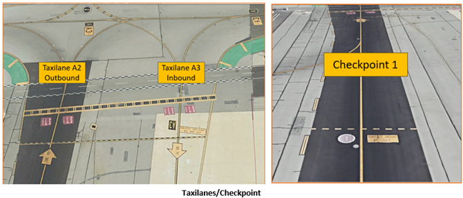
- Taxilanes (TXL) A2 and A3 are not controlled by ATC.
- TXL A2 used for eastbound taxiing only – one way traffic, follow yellow arrows.
- TXL A3 used for westbound taxiing only – one way traffic, follow yellow arrows.
- On-pavement markings outbound on TXL A2 identify Checkpoint 1. Pilots are requested to call for taxi clearance just prior to reaching this location. (See above illustration)
Arrival/Landing
- The Newhall Pass is a high-density traffic area with VFR aircraft transiting northbound and southbound, hang gliders operating north of the pass and a continuous flow of IFR arrivals descending via the ILS RWY 16R approach to KVNY.
 Additional Information
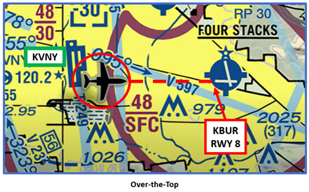
- Use caution for over-the-top aircraft on final approach course for BUR ILS RWY 8. VNY is not in radio communication with these aircraft.
- Use caution for wake turbulence from the aircraft overhead.