


Beyond the Briefing: Navigating the Physics-Based Traps of Wild Weather

While the mantra “don’t fly in bad weather” is sound advice in theory, the reality of the cockpit is often much more complex. Weather is dynamic; it evolves faster than the standard briefing cycle can refresh.
A pilot might depart in clear conditions only to encounter a localized microburst or a rapidly maturing convective cell along their route. To survive these encounters, pilots must move beyond simply reading a METAR (meteorological aerodrome report). Understanding the raw mechanics of extreme weather allows a pilot to recognize the warning signs in the windshield long before they appear on a tablet screen.
Basic flight training teaches students to fly a wide arc around convective weather. However, extreme weather rarely presents itself as a solid, immobile wall. Instead, it acts as a series of traps. For general aviation (GA) aircraft, which often lack the climb performance to top weather or the structural mass to absorb high-velocity impacts, these traps are particularly lethal. In the GA realm, the margin for error isn't just thin — it can vanish in seconds.
“There is no disgrace in deciding not to go, divert, or do a complete 180 turnback to your departure airport when the weather changes unexpectedly,” said FAA Aviation Safety Inspector Marcel Bernard. “Don’t ignore the obvious and take advantage of real-time weather access. When you have any doubts about acceptable weather conditions for your flight, always have plan B and execute it as necessary. There have been many times when I have done just that and was relieved of the stress of flying in unfavorable, unexpected, or hazardous weather conditions.”
The 20-Mile Danger Zone
The FAA recommends a minimum 20-nautical-mile buffer from severe thunderstorms because hazards like tornadoes can extend far beyond the visible storm. While tornadoes are spawned by thunderstorms, they do not have to remain within the boundaries of the storm. They are erratic and often move at ground speeds exceeding 60 knots.
While scientists continue to debate the exact triggers of tornado genesis, we know they result from extreme atmospheric instability and wind shear. For a pilot, a tornado represents an environment of aerodynamic extremes far exceeding the structural design limits of light aircraft. But the dangers of a tornado extend far past the funnel cloud. Tornadic winds, which can exceed 200 knots, cause extreme wind shear and turbulence and loft trees, vehicles, and other debris into the air. Knowing what to watch for is crucial to staying well clear of the danger zone:
- Inflow Bands or "beaver tails:” Beware of smooth, flat cloud bands extending from the eastern edge of a rain-free base toward the east or northeast. These suggest the storm is actively sucking in low-level air, creating a spiraling inflow that precedes rotation.
- The Wall Cloud: This is a localized, persistent lowering from the rain-free base. If you see this area begin to rotate, a funnel is likely imminent.
- Rear Flank Downdraft (RFD): Watch for a "clear slot" or a brightening near the wall cloud. This indicates cold air is wrapping around the storm's backside, often the final mechanical "shove" needed to drop a tornado to the ground.
Pilots should never attempt to fly anywhere near a tornado. Since tornadoes usually form from supercell thunderstorms, avoiding these weather conditions altogether is the safest option.
The High-Altitude Kinetic Trap
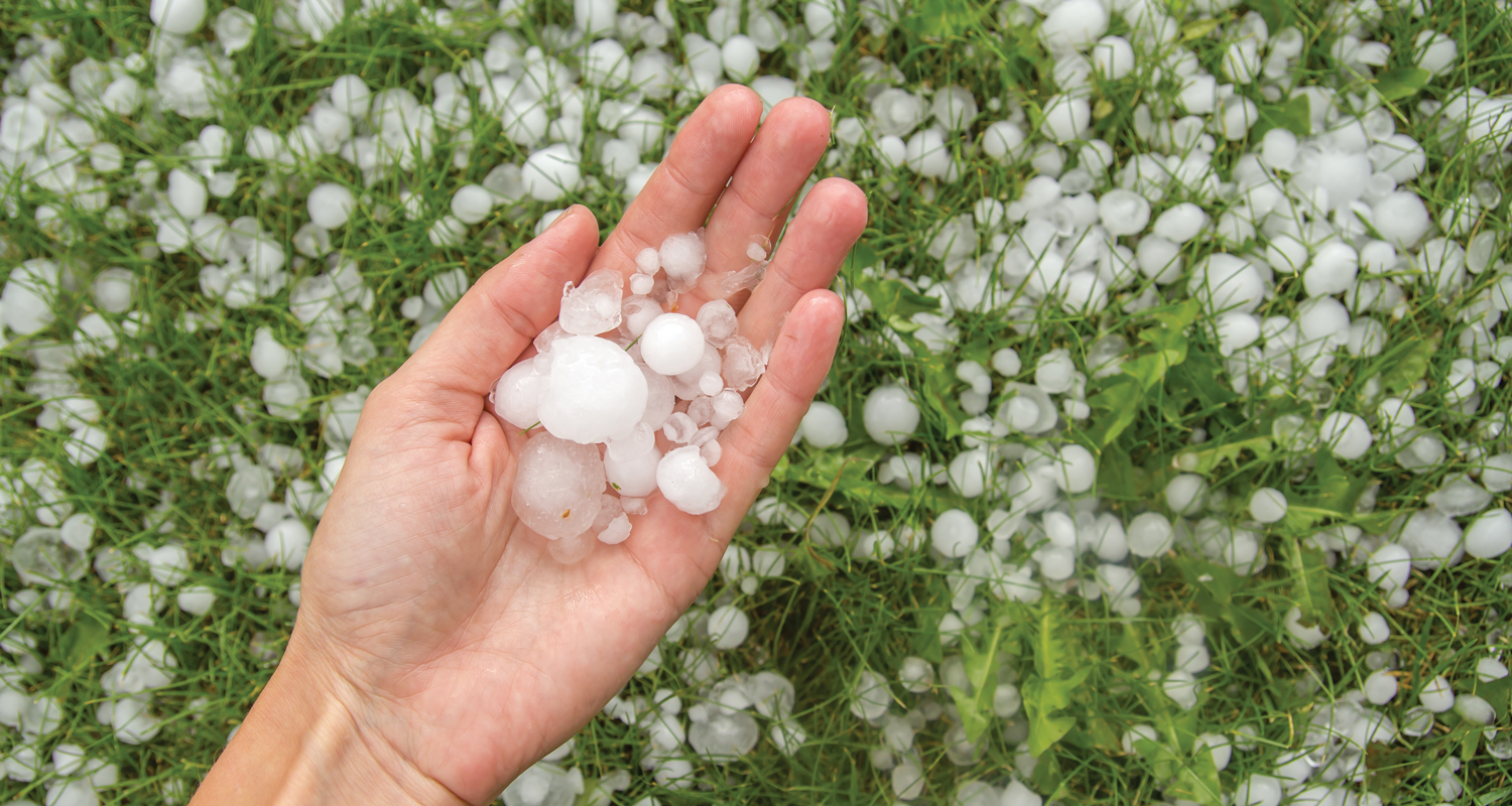
Like tornadoes, hail is a product of violent vertical energy. Hailstones are forged in the updraft, often passing through the freezing level multiple times and growing larger with each cycle before gravity finally wins. Hail is a kinetic trap.
Even if hail isn’t present at the surface, large hail is almost always present in the upper levels of a severe cell. Strong updrafts can eject hailstones horizontally, meaning pilots can encounter airframe-shattering ice up to 20 miles downwind of the storm core. For a light aircraft, hail doesn't just dent the skin; it can shatter windscreens and deform the leading edge of a wing, significantly impairing lift. Pilots must take care to avoid hail. Even commercial airliners have been forced to land after hail has caused severe damage in-flight.
To avoid encountering this kinetic trap, it is crucial to recognize storm features that produce hail. Watch for heavy rain mixed with large, bright, or rapidly changing precipitation. Storms are more likely to produce hail when strong updrafts are present. Be sure to watch for turbulence and wind shear, which are also common in hail-producing storms.
The Invisible Structural Load
At its most basic level, turbulence is caused by disrupted airflow. Instead of moving in a smooth, predictable stream, it becomes chaotic, swirling, and irregular. Airflow can be disrupted by physical objects such as mountains or urban structures, but most turbulence is weather-driven. Weather can lead to convective turbulence, frontal turbulence, and clear air turbulence. National Transportation Safety Board data shows that approximately 57.7% of turbulence-related accidents are caused by convective activity. Turbulence is more than just a discomfort; it is a series of rapid, high-magnitude G-load fluctuations.

Turbulence comes from several sources: thermal currents, wind shear, temperature inversions, and mountain waves. The trap here is clear air turbulence (CAT). It occurs without visual warning, often miles away from the visible clouds of a thunderstorm or thousands of feet above the anvil. Even though convective turbulence causes more accidents, clear air turbulence is a close second at 28.8%.
Preflight planning, real-time monitoring, and in-flight adjustments are the best ways to reduce encounters with turbulence. Beyond G-AIRMETs and SIGMETs, look for "mountain wave" signatures on satellite imagery if flying near ridges. Be especially wary in the afternoon during summer months when convective currents are at their peak. When pilots encounter unexpected chop, they should slow to their aircraft’s maneuvering speed (Va) to protect the airframe's structural integrity.
The Performance Limit Bolt
Microbursts are small, intense pockets of sinking air that can be part of larger wind systems. For a landing or departing aircraft, they are a nightmare of disappearing performance. This trap has three stages:
- Formation: Precipitation falls and evaporates, cooling the air and making it denser and heavier.
- Impact: The cold "slug" of air hits the ground and spreads out in all directions.
- Dissipation: The wind moves away from the impact point, often leaving a "curl" or dust ring on the ground.
As you fly into a microburst, you first encounter a strong headwind (increasing performance). The trap is the sudden transition to a massive downdraft followed by a strong tailwind. This creates a "performance vacuum" that can exceed the climb capability of any piston engine.
GA aircraft have less thrust reserve and margin of error, so, as with other wild weather traps, avoidance is the best course of action. Be on the lookout for cumulonimbus clouds, turbulence, or downdraft indicators. Unstable air with strong wind shear — atmospheric instability — can trigger microbursts. Sometimes visual cues are present. Watch for rain that evaporates before hitting the ground and a swirling dust cloud at the surface.
Plan ahead and consider rerouting or delaying when thunderstorms are expected. Monitor weather continuously and climb or turn away when a storm or gust front is detected. If pilots encounter microbursts, they should reduce speed to give themselves more time to react. In an updraft, climb slowly and change course slightly outward from the storm center. In a down draft, descend slowly and slightly adjust course toward the center. In this situation, pilots should maintain instrument discipline and avoid relying on visual cues.
The Silent Decay of Lift
Icing is a subtle trap that changes the very physics of how your wing works. It doesn’t just make the aircraft heavier; it fundamentally alters the aerodynamics. Icing is a cumulative hazard. The longer an aircraft collects ice, the worse the hazard becomes.
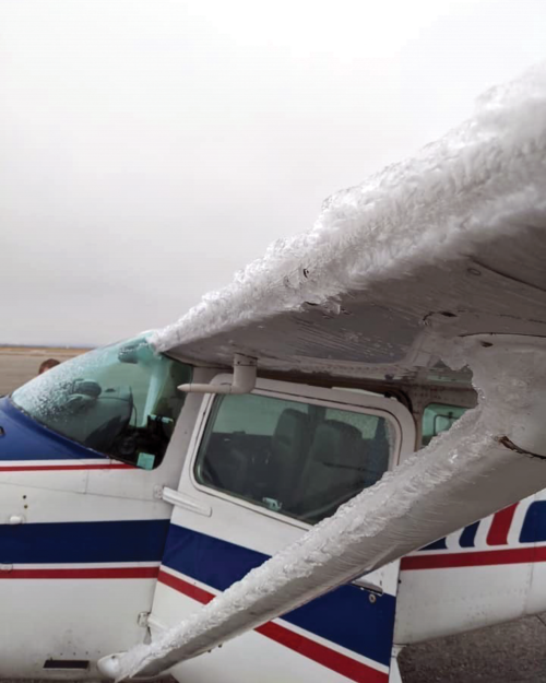
This weather trap usually requires two things: visible moisture and temperatures at or below freezing, although some structural icing can occur at temps above freezing. The most dangerous icing often occurs in the top few thousand feet of cloud decks or in convective cells where supercooled large droplets exist. These droplets remain liquid below freezing until they contact the airframe. This impact provides the necessary “shock” to trigger an instantaneous freeze that coats the wings, windshield, and propeller in ice. The resulting ice doesn't just add weight; it increases drag by as much as 100% while reducing maximum lift by 30%.
Icing can also present hazards with engines and instruments. Carburetor icing can occur even on warm, humid days due to the venturi effect cooling the intake air. To learn more about carburetor icing, check out “Breaking the Ice,” in the Sept/Oct 2023 issue of FAA Safety Briefing. For GA pilots, this manifests as a mysterious drop in rpm or manifold pressure. Pitot-static icing can lead to erroneous airspeed and altitude readings.
Pilots should watch for icing conditions like temperature inversions. Be aware that the temperature doesn't always drop as the aircraft climbs. Pilots may find "warm" air aloft that is actually dropping freezing rain into the colder air below. This is a recipe for rapid, severe icing.
Icing is a major aviation hazard. The best way to deal with this wild weather trap is to avoid it altogether. If an aircraft lacks de-icing equipment, the only safe strategy is a 180-degree turn or a calculated altitude change to exit the visible moisture or find warmer air. Advisory Circular (AC) 91-74B, Pilot Guide: Flight in Icing Conditions, has more information on the principal factors related to flight in icing conditions.
The Interconnected System
While these five hazards can occur independently, they are usually byproducts of the same phenomenon: the life cycle of a thunderstorm. Check out “Steering Around the Storm” in this issue for a better understanding of the significant hazards they pose, and how to stay safe. The National Weather Service motto says it best: “Be weather aware and fly prepared.” Understanding the physics-based traps posed by wild weather is more than just reacting to the hazards; it is anticipating them and staying well clear. Pilots should always check the latest conditions, study the forecasts, and always — always — have a “Plan B” before the trap snaps shut.
Learn More
- Ice Induced Stall Pilot Training Video
- Predicting Icing Conditions in 57 Seconds Video
- FAA Aviation Weather Handbook
- NWS, What is a Microburst?
- Microbursts: What Makes Them So Dangerous? (Pilot Institute)