
Akron-Canton Regional Airport (CAK)
Akron-Canton Regional Airport (CAK) is located between the cities of Akron and Canton in northeastern Ohio. The traffic mix includes commercial, military, cargo and both transient and local general aviation aircraft, with over 50,000 RWY operations per year. The taxiway system connects the runways to all commercial and military facilities. View a printable Pilot Handbook of the CAK information found on this Web page.
 Know Before You Go
ATCT Operates: 24/7
Administrative Office: Open 0700L to 1500L M-F
Business Phone: 330-492-3801
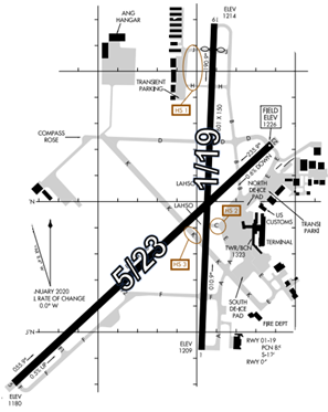
The airport configuration consists of RWY 1/19 and RWY 5/23.
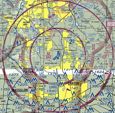
The airspace at CAK is Class C and underlies the 30NM Mode C & ADSB Cleveland Class B veil.
(Refer to Sectional Chart.)
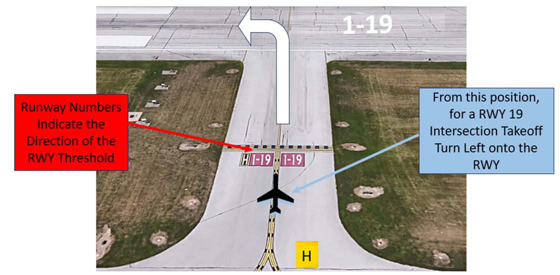
Wrong Surface Intersection Takeoff
- At CAK, or at any facility where intersection take offs are authorized, there is the risk that pilots will turn in the wrong direction when turning onto the RWY.
- It is critical to verify the correct direction prior to lining up on the RWY.
- Always check your Magnetic Compass and (if installed), your Horizontal Situation Indicator (HSI) to verify that you are pointed in the correct direction.
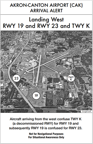
Wrong Surface Landing Risk
See Arrival Alert Notice
- If available, back up all visual approaches with an instrument approach or GPS Waypoint to help ensure that you are lined up for the correct surface.
- RWY markings are white. Markings on surfaces not used for takeoff/landing like TWY markings, chevrons, RWY shoulder and RWY turn-on markings etc., are yellow.
- View the From the Flight Deck-Wrong Surface Landings video for additional mitigation strategies.
Traffic Patterns
- Left and right patterns available for all RWYs with pattern altitude at 2200’ MSL. We may use a “Figure 8” pattern, alternating RWYs, with pattern traffic for volume or efficiency.
RWY Crossings
- Aircraft exiting RWY 5/23 at TWY K must pay close attention to instructions.
Takeoff/Departure
- Standard IFR departure is RWY heading climb to 3000’.
- VFR departures are restricted at or below 3000’.
- All VFR aircraft must receive Class C services.
Arrival/Landing
- RWY 19 threshold is displaced 601’ and coincident with TWY J.
- Pilots are expected to exit the RWY onto available TWY as soon as possible.
- DO NOT exit onto a crossing RWY unless TWR has directed you to do so.
- Always verify that your magnetic compass aligns with the appropriate RWY heading to ensure you have the correct surface in sight.
- TWR may conduct pattern and practice approaches to the crossing RWY.
- Restricted low approaches that are 500’ above the RWY may be used to provide separation between other aircraft landing on the crossing RWY.
- Land and Hold Short Operations (LAHSO) on RWY 5 and RWY 19.
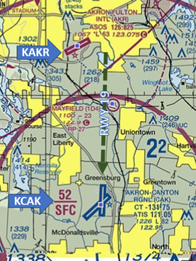
Caution - Watch for aircraft in the Akron Fulton International Airport (KAKR) traffic pattern when arriving on RWY 19.
Weather
- Pilots should be aware of weather before flight and ask for PIREPs during flight to stay in the know.
Avoidance Areas/Critical Areas
- RWY 19 ILS Critical Area begins in the non-movement area of the northwest FBO ramp. It encompasses TWYs H and J west of RWY 19 and the portion of TWY B north of J.
- RWY 23 ILS Critical Area begins on TWY B north of TWY D.
Special Traffic (Military / Commercial / Helicopter, etc.)
- The intersection of TWYs K and D are primarily used for the takeoff and landing of Ohio National Guard H47 Chinook and H60 Black Hawk helicopters. The Guard TWY leads north from this intersection and may be used for helicopter hover work and other operations.
- First Energy helicopters takeoff and land adjacent to the RWY 23 approach end and are restricted from overflying the FBO and Terminal Ramps.
- Hot Air Balloon traffic is expected during the last weekend in July due to the Pro Football Hall of Fame Balloon Classic activities. The balloons, are easily visible, are not required to have an operational transponder or ADS-B.
Additional Information
- The TWR, built in 1962, is attached to the terminal.
- Areas not clearly visible from the TWR include non-movement areas in the northeast and northwest hanger complexes.
- Aircraft on Gates 1-3 are obstructed from view until aircraft push back.
- There are visibility issues at the approach end of RWYs 5 and 19. Vehicles and aircraft are visible however, exact position in relation to the RWY Safety Area/ILS Critical Area is difficult to discern.
Special Events
- The PGA Tour Kaulig Companies Championship at Firestone Country Club is typically held during the second weekend in July.
- The Hall of Fame Balloon Classic is held during the last weekend in July.
- The Pro Football Hall of Fame Game and Enshrinement Festival is held during the first weekend in August.
- The CAK 5K Run, which takes place on the RWY, is typically scheduled in October.