
Fort Worth Meacham International Airport (FTW)
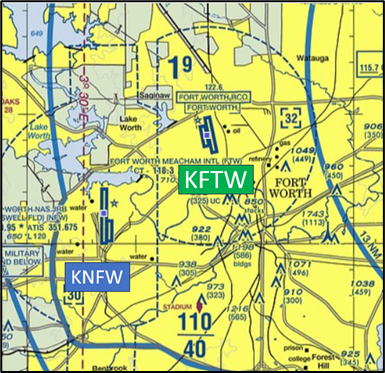
Fort Worth Meacham International Airport (FTW) in Fort Worth, Texas is a general aviation airport located approximately 15 miles southwest of Dallas/Fort Worth International Airport. Pilots should also be aware of the airport's proximity to the busy Fort Worth Joint Reserve Base (NFW), located five miles southwest. Meacham's current facilities include three full-service FBOs, aircraft maintenance facilities and flight schools. View a printable Pilot Handbook of the FTW information found on this Web page.
Know Before You Go
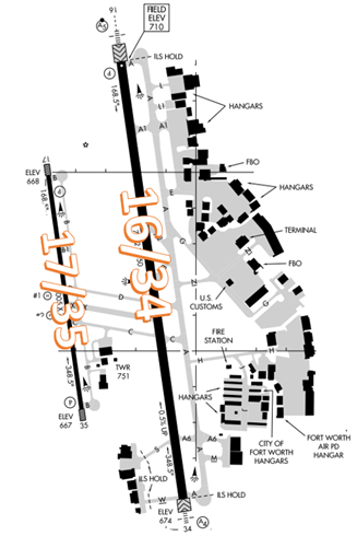
- The RWY configuration consists of parallel RWYs 16/34 and 17/35.
- The airspace at FTW is Class D and underlies Dallas-Ft. Worth Class B. (See sectional chart)
Below find various FTW-specific information and things to be aware of, as well as general information to inform your preflight planning. This will be reviewed quarterly and updated as needed. This information is to supplement the From the Flight Deck Videos that are produced by the FAA Runway Safety Group. Here you will also find information provided by the local air traffic controllers at the airport where you intend to fly. The information is subject to change. Not for navigation or legal* pre-flight action. Always refer to official pre-flight materials such as, but not limited to, NOTAMs, airport diagrams, VFR charts and airport construction notices for the latest airport-specific details.
FTW ATCT Operates: 24 hours
Administrative Office: Open 0800L to 1600L M-F
Business Phone: 817-740-3300
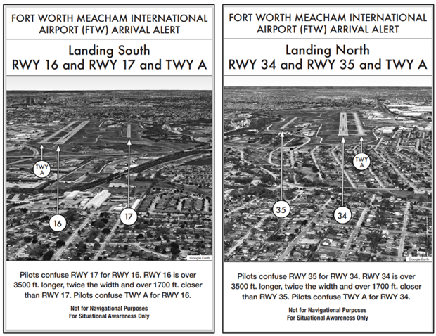
Wrong Surface Landing Risk
- Wrong Surface Landing risk exists due to closely spaced parallel RWYs with staggered thresholds - See Arrival Alert Notices.
- Whenever a TWY runs parallel to a RWY, the risk of landing on a TWY increases.
- If available, back up all visual approaches with an instrument approach/GPS to help ensure that you are lined up for the correct surface.
- View the From the Flight Deck-Wrong Surface Landings video for additional mitigation strategies.
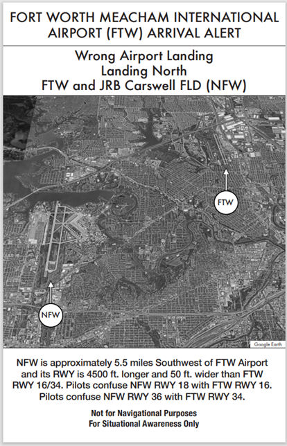 Wrong Airport Landing Risk
- Wrong Airport Landing risk exists due to proximity to NFW. See Arrival Alert Notices.
- During pre-flight planning, check the sectional chart for airports in close proximity and charted reporting points.
- Use the most precise navigational aids available such as GPS, localizers, or VOR radials to positively identify the airport.
- If you're talking to ATC and you're unsure, ask the controller.
- View the From the Flight Deck-Wrong Airport Landings video for more information and mitigation strategies.
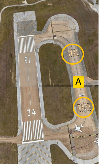
Surface Risk – Movement Area Cautions
- TWY A parallels RWY 16/34 and pilots have confused TWY A with the runway.
- To assist in mitigating this risk, TWY A has “TAXI” painted on it at both ends to help pilots recognize it as a TWY and not a RWY.
General
- Practice good radio etiquette to avoid frequency congestion. Please include your call sign with all hold-short instructions, and runway assignments.
- RWY 4R and RWY 4L are preferred RWYs when wind conditions are less than 5 kts.
Ground Control
- TWY N and Taxi-lane H (on the east side of the airport) have been added to eliminate congestion and complexity while transiting to the FBOs and resident hangars. Because of these recent changes, there are large areas of unused or closed concrete that may lead to a loss of situational awareness while taxiing.
- TWR visibility is limited in certain areas – most notably in the ramp areas from the northeastern FBO to the midfield FBO.
- TWY visibility is also limited in the area on the eastern-most ramp near the fire station.
- Aircraft located in these areas may not be visible from the TWR.
- Some aircraft, clearing the RWY, are proceeding to parking without contacting ATC. Do not taxi to parking prior to receiving clearance from the TWR or Ground Control.
Arrival/Landing
- Do not mistake TWY A for RWY 16/34.
Special Traffic-Helicopters
- Increased helicopter operations on west side of the airport.
Additional Information
- Though not depicted on the Sectional Chart, RWY 17 and RWY 34 use Right Patterns whenever TWR is closed.
- Check Chart Supplement for additional remarks.