
Grand Canyon National Park Airport (GCN)
Grand Canyon National Park Airport (GCN) is a small single runway airport located near the southeast rim of the Grand Canyon in Arizona. The airspace north of the airport's Class Delta airspace is highly regulated and restricted. Flying to GCN requires detailed pre-flight planning to become familiar with the rules and requirements to operate in and around the surrounding areas. View a printable Pilot Handbook of the GCN information found on this Web page.
Know Before You Go
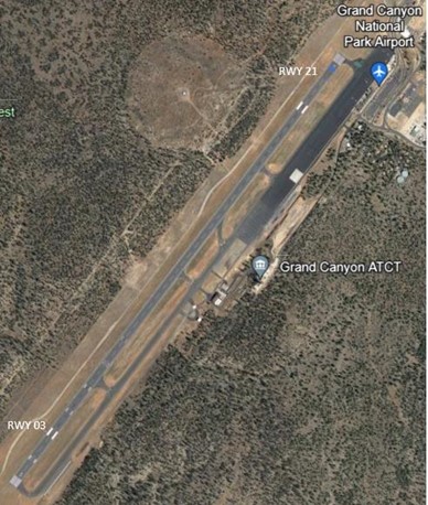
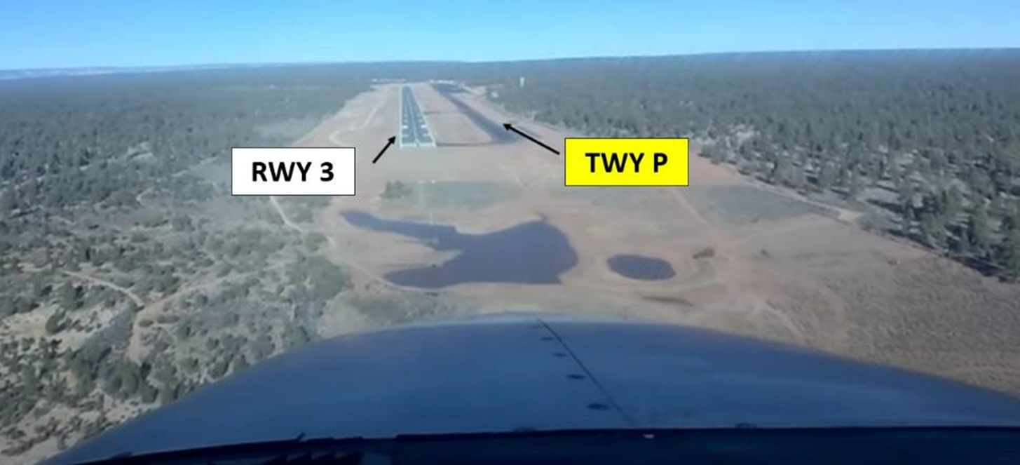
The RWY configuration consists of single RWY 3/21.
A full-length parallel TWY is south of the RWY.
Remember: Surface Markings used for Takeoff/Landing are painted White
Traffic volume is seasonal, with heavy traffic periods primarily occurring during the summer months.
GCN Tower Hours of Operation: Jun 1-Sep 30 0600L-2000L/ Oct 1-May 31 0700L-1900L.
Administrative Office Open 0630L to 1430L–M through F. Business Phone 928-638-2850
Tour companies that provide aerial views of the Grand Canyon operate most of the traffic at the airport. The fleet mix is mostly helicopters but does include large single and turboprop twin-engine aircraft.
Traffic volume is seasonal, with heavy traffic periods primarily occurring during the summer months.
The airspace at GCN is Class D. (Refer to Sectional Chart.)
Wrong Surface Intersection Takeoff
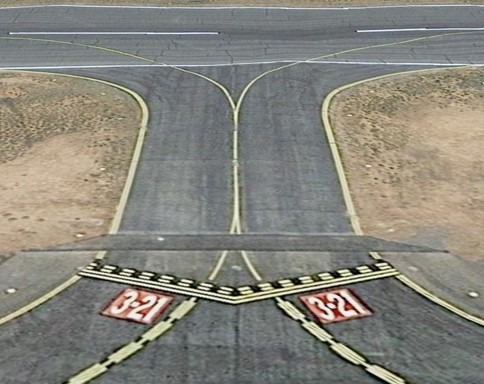
The risk exists for a Wrong Surface Intersection Takeoff. Using the above example.
- If cleared for a RWY 3 Intersection Takeoff, you would turn onto the RWY to the RIGHT.
- If cleared for a RWY 21 Intersection Takeoff, you would turn onto the RWY to the LEFT.
- CHECK YOUR MAGNETIC COMPASS/HORIZONTAL SITUATION INDICATOR (HSI).
Additional Cautions
- Be aware that during the summer months, Density Altitude may be an issue for some aircraft. GCN field elevation is 6,609’ MSL.
- Tour companies that provide aerial views of the Grand Canyon operate most of the traffic at the airport.
- The fleet mix is mostly helicopters but does include large single and turboprop twin-engine aircraft.
- Heavy snow becomes the issue during the winter months, check NOTAMs for snow removal operations and runway closures.
- There is a parachuting operation on the field, and the landing zone is just southeast.
- The airport is temporarily closed to arrivals and departures while jumping is in progress.
General
- IFR departures are not authorized from RWY 3 due to SFRA north of GCN class D.
- Tower often transmits on multiple frequencies simultaneously. Listen actively and be aware that you might hear transmissions meant for aircraft on different frequencies.
- Density altitude advisories common during warm weather. May affect takeoff/landing distances.
Traffic Patterns
- RWY 21 arrivals expect midfield downwind pattern entry.
Ground Control
- There is no designated run up area for RWY 21. Common practice is run up on the ramp prior to taxi.
- Radar service is not available off the ground; upon leaving class D airspace pilots may contact Los Angeles ARTCC on 124.85 for radar service.
Departure/Arrival
- Use caution for low level helicopter operations within class D at or below 300’ AGL. RWY 21 arrivals maintain at or above 7200 until established on final. All departures fly runway heading until leaving 7200.
- Turbojets should enter GCN class D airspace at or below 200kts as practicable.
- VFR arrivals contact tower between 10-20 miles from airport for pattern entry instructions.
- Departing aircraft intending to transit the corridors should expect a southbound departure to climb to appropriate altitude.
Avoidance Areas
- Two-way communications with GCN ATCT does not imply permission to enter the SFRA north of GCN class D. Plan to make all pattern turns within class D airspace unless otherwise directed by tower.
- Also see Grand Canyon VFR Aeronautical Chart (faa.gov)
Special Traffic (Military / Commercial / Helicopter, etc.)
- Military aircraft (including Heavy) often utilize GCN for closed traffic and practice instrument approaches. Be prepared for wake-turbulence separation.
- Use caution for parachute jump activity at GCN airport. Be prepared to remain outside of GCN class D airspace while parachute jump operations are in effect.
Additional Information
- Tower radar coverage unavailable below 9000 MSL. GCN field elevation is 6,609 MSL.
- Corridor altitudes 11500 and 13500 northbound, 10500 and 12500 southbound, frequency 120.05. Refer to GCN sectional chart. (Tour operators operate at 9500)