
Hilton Head Airport (HXD)
Hilton Head Airport (HXD), also known as the Hilton Head Island Airport, is located near the northeastern shoreline of Hilton Head Island, South Carolina. Airport operations consist of general aviation, student training and non-scheduled and scheduled commercial passenger operations. View a printable Pilot Handbook of the HXD information found on this Web page.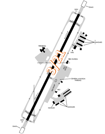
Know Before You Go
HXD Tower Hours of Operation 0700-2100L
Administrative Office Open 0700L to 1500L M-F
Business Phone 843-342-4940
The airport configuration consists of a single RWY designated 3/21. There is a passenger terminal located on the west side of the RWY with the remaining services, flight schools, and facilities on the eastern side of the airfield.
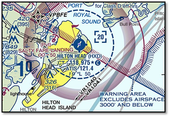
The airspace at HXD is Class D. (Refer to Sectional Chart)
Below find various HXD-specific information and things to be aware of, as well as general information to inform your preflight planning. This will be reviewed quarterly and updated as needed. This information is to supplement the From the Flight Deck Videos that are produced by the FAA Runway Safety Group. Here you will also find information provided by the local air traffic controllers at the airport where you intend to fly. The information is subject to change. Not for navigation or legal* pre-flight action. Always refer to official pre-flight materials such as, but not limited to, NOTAMs, airport diagrams, VFR charts and airport construction notices for the latest airport-specific details.
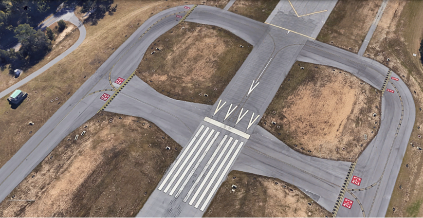
Wrong Surface Landing Risks
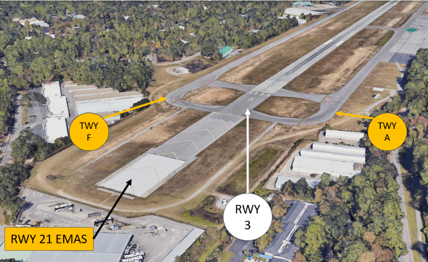
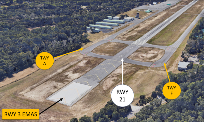
- Whenever a TWY runs parallel to a RWY, the risk of landing on a TWY increases.
- As an awareness item, HXD RWY 3/21 has parallel TWYs on both sides.
- When available, back up all visual approaches with an instrument approach/GPS waypoint to help ensure that you are lined up for the correct surface.
- RWY markings are white. Markings on surfaces not used for takeoff/landing like TWY markings, chevrons, RWY shoulder and RWY turn-on markings etc., are yellow.
- View the From the Flight Deck-Wrong Surface Landings video for additional mitigation strategies.
Surface Movement Area Cautions
- RWY 3 has a 297’ displaced threshold and RWY 21 has a 403’ displaced threshold. At HXD, the portion of RWY behind a displaced threshold is available for takeoffs in either direction or landings from the opposite direction.
- Pilots that require full-length departure or that will be conducting a run-up at the RWY should advise Ground Control (GC) when requesting taxi instructions.
General 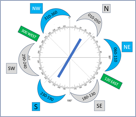
- HXD Tower does not have surveillance systems (RADAR) to determine aircraft locations. This has led to several issues with aircraft mis-identifying their cardinal position from the airport and pilots occasionally entering the wrong traffic pattern for the wrong runway.
- When reporting inbound, pilots need to relay their position in relation to the airport. This diagram depicts where the controllers expect you to be when you are relaying your position.
Traffic Patterns
- Left traffic is published for both RWY 3 and RWY 21 though the tower may instruct aircraft to use whatever pattern is necessary to accommodate traffic.
Ground Control
- Ground Control and Clearance Delivery are normally combined on one frequency. This may result in multiple aircraft calling one controller that is working two frequencies. Pilots may hear a controller make a transmission without a response from the aircraft on the other frequency. Be patient and listen for your call sign.
- Transient pilots sometimes confuse parking assignments instructions issued by ATC. If you have any questions about your instructions or location, please ask.
Arrival/Landing
- VFR aircraft conducting practice instrument approaches will be provided standard IFR separation by Savannah Approach Control when the tower is operational. Pilots should review NOTAMS for the Letter to Airmen “IFR Separation for VFR Aircraft conducting Practice Instrument Approaches” LTA-SAV-21 for more information.
Additional Information
- Parasailing operations within a 3 NM radius of SAV 009 Degrees/15NM from the surface to 1500’ during daylight hours.
- Numerous birds and wildlife on and in the vicinity of the airport can be hazardous.
- Scenic helicopter tour operations land/depart from the airfield.
- Runway 3/21 at HXD is grooved for water drainage.
- Numerous military aircraft, both fixed wing and helicopters operate in the area.