Boeing 757-223
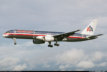
Photo copyright Gerard Helmer - used with permission
American Airlines Flight 965, N651AA
Cali, Colombia
December 20, 1995
On the evening of December 20, 1995, at approximately 2142 Eastern Standard Time (equivalent to Cali, Colombia local time), American Airlines Flight 965 crashed into high terrain during approach to Alfonso Bonilla Aragon International Airport, Cali, Colombia. Of the 163 people on board only four survived. The weather conditions that night were relatively clear skies and light surface winds with no moon.
The airplane involved in this accident, a Boeing 757, was equipped with cathode ray tubes (CRT), or "glass cockpit" technology, including screens which display flight path and navigation information, engine information, and a Flight Management System (FMS). A Ground Proximity Warning System (GPWS) was also installed and functioned normally at the time of the accident.
The investigation concluded that this accident was attributed to flight crew human error involving navigational and crew resource management lapses. This Controlled Flight Into Terrain (CFIT) accident became the catalyst for requiring the installation of terrain awareness and warning systems (TAWS) in transport airplanes.
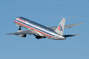
Photo copyright Mark Abbott - used with permission
History of Flight
American Airlines Flight 965 was a regularly scheduled passenger flight between Miami International Airport (MIA), Florida and Alfonso Bonilla Aragon International Airport (SKCL) Cali, Colombia. The airplane, a Boeing 757-200 with 155 passengers and a crew of eight, departed Miami approximately two hours behind schedule at 1835 Eastern Standard Time (EST) on December 20, 1995. Delays were attributed to waiting for connecting passengers and were compounded by a lengthy ground delay due to gate congestion. There was no significant maintenance or operations-related discrepancies on the airplane.
The planned route took Flight 965 south through Cuban airspace, Jamaican airspace, and into Colombian airspace where the flight was eventually cleared by Bogota Center to fly direct from BUTAL [intersection] to the Tulua VOR (ULQ) which was located approximately 36 nautical miles to the north of the arrival airport. Loaded in the Flight Management System (FMS) was the planned arrival route which was to fly from Tulua VOR to ROZO NDB (R), then to the Cali VOR (CLO), located 7.5nm south of the airport, for a procedure turn to an ILS approach to runway 01. View ILS 01 approach chart.
Both the captain and the first officer had received specific training in Latin American operations, and both had previously operated in South America. The captain had flown into Cali 13 times before without incident, though the accident investigation board concluded that it was likely that he had only landed at night which may have limited his appreciation for the presence of mountains along either side of the approach into Cali. The first officer was at the controls for this approach, and this was his first flight into Cali.
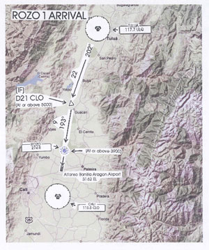
Alfonso Bonilla Aragon International Airport (SKCL) is situated at the southern end of a long north-south valley at an altitude of 3,160 feet. The valley is surrounded by mountain ridges on the east and west sides that in areas rise to 14,000 feet. The valley is approximately 25 miles wide in the Cali area, but is significantly narrower farther north near the towns of Buga and Tulua. Information contained in the SKCL approach plates indicate that the Minimum Safe Altitude (MSA) in the northwest quadrant, centered on the Cali VOR and extending out 25 miles, is 14,900 feet. Radar coverage and radar services were not available in the Cali airspace at the time of the accident.
Cali weather had been reported as clear, visibility greater than 10 kilometers and scattered clouds. Flight 965 had requested descent clearance and was cleared by Colombian air traffic control (ATC) first to flight level 240, then flight level 200 before being handed off to Cali Approach Control. The flight was uneventful until it entered the Cali approach airspace. Based on discussion between flight crew members recorded on the cockpit voice recorder (CVR), flight 965's late departure from Miami had created operational concerns related to adequacy of flight attendant crew rest time and subsequent availability for the next day's flight.
Flight 965 checked in with Cali approach control at 2134:40 and advised the controller they were descending through flight level 230 to flight level 200. The captain reported that Flight 965 was 63 miles from Cali VOR. Approach control cleared the flight to Cali VOR, provided the local altimeter setting, and directed the flight to descend and maintain 15,000 feet and report arrival over the Tulua VOR (ULQ). The captain replied, "OK, understood. Cleared direct to Cali VOR. Uh, report Tulua and altitude one five, that's fifteen thousand three zero...zero...two. Is that all correct sir?" The controller stated, "Affirmative." The captain then informed the first officer that he had put a route "direct to" Cali VOR into the Flight Management System (FMS) computer. Due to the existing FMS logic, the action of entering Cali VOR as a "direct to" routing removed the interim waypoints from the navigation display map mode flight path. This meant that the next assigned reporting point, Tulua VOR, was no longer displayed on the navigation map display. Also removed from the displayed flight path was the ROZO non-directional beacon (NDB).
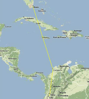
View Larger
At 2136:31 Cali approach control informed Flight 965 that the wind was calm and inquired if Flight 965 was able to execute the VOR DME approach to runway 19. This prompted a four-second exchange between the captain and first officer in which the captain asked, "Would you like to shoot the one nine straight in?" The first officer responded, "Yeah, we'll have to scramble to get down. We can do it." This interchange followed an earlier discussion in which the captain indicated to the first officer his desire to hurry the arrival into Cali in an apparent attempt to minimize the impact of the delay out of MIA on the flight attendants' crew rest requirements. This also followed a request by the captain to the first officer 10 minutes prior to "Keep up the speed in the descent." The captain accepted the Cali approach controller's offer with, "Uh yes sir, we'll need a lower altitude right away though." The approach controller then stated, "Roger. American nine six five is cleared to VOR DME approach runway one niner Rozo number one arrival, report Tulua VOR." The captain acknowledged the clearance, but only stated, "...will report the VOR..." to which the controller stated, "Report uh, Tulua VOR." The captain replied, "Report Tulua."
The acceptance of runway 19 would save considerable time as the crew could make a straight-in approach to the runway at Cali, instead of having to fly past the airport and conduct the procedure turn prior to joining the final approach course to the reciprocal runway. But the runway change meant that the flight now had to reach the final approach altitude of 5,000 feet 21 miles sooner, which necessitated a rapid descent.
The runway change also meant that there were a number of actions that needed to be accomplished expeditiously. At 2137:11 the sound of papers rustling was recorded on the CVR and was assumed by the investigators to be the sound of the VOR/DME runway 19 approach chart and the ROZO One Arrival chart being located, removed from their binders, and positioned for reference in the cockpit. The flight crew would be have been involved in reviewing the new approach charts for relevant information such as radio frequencies, headings, altitudes, distances, and missed approach procedures, along with performing FMS data entry and verification of data for the new approach. These tasks would need to be accomplished while recalculating airspeeds, altitudes, configurations and other aircraft control factors - all while navigating and communicating with ATC in mountainous terrain. A formal approach briefing for the VOR/DME approach to runway 19 was not recorded on the CVR. An approach briefing would be expected as part of normal flight deck procedures.
At 2137:29, to simplify navigation, the captain requested to the approach controller, "Can American airlines uh, nine six five go direct to Rozo and then do the Rozo arrival sir?" The Cali approach controller replied, "Affirmative. Take the Rozo one and runway one niner, the wind is calm." The captain responded, "Alright Rozo, the Rozo one to one nine, thank you, American nine six five." The controller stated, "...report Tulua and e'eh, twenty one miles ah, five thousand feet." The captain responded, "OK, report Tulua twenty one miles and five thousand feet, American nine uh, six five."

Photo copyright Yuxiaobin - used with permission
At this point, the flight crew believed they had been cleared to the ROZO NDB which lies 2.6 miles north of the runway 19 threshold on the final approach course. Due to the surrounding terrain and lack of ATC radar coverage, it was critical to the safety of the approach that Flight 965 fly the ROZO 1 Arrival, as instructed by the controller, which started at the Tulua VOR. However, the TULUA waypoint would no longer have been displayed on the navigation display map as interim waypoints were removed when the "direct to" command had been selected by the captain. At this time Flight 965 would have been very close to the Tulua VOR.
To assist with the rapid descent, the first officer had deployed the speed brakes while descending through 17,000 feet, and they remained deployed for the remainder of the flight. While the flight continued descending, the captain or the first officer attempted to enter the identifier for the ROZO NDB in the FMS as the active waypoint. Entering the ROZO NDB identifier, "R" into the Central Display Unit (CDU), as it appeared on the paper copy of the approach chart, resulted in a display of 12 selectable waypoints, listed in order of their proximity to the airplane. The ROZO NDB was not one of the selectable waypoints. Based on its proximity to the airplane, the nearest selectable waypoint would have been the Romeo NDB located to the northeast, near Bogota, Colombia. The FMS database selection should not have activated the "ROZO" NDB as the active waypoint, although it was concluded later by the investigation that the crew believed it had been.
It was later determined that the FMS database was programmed to activate the ROZO NDB only if it's full name "R-O-Z-O" was entered into the FMS CDU. The investigation concluded that in their confusion and haste, a flight crew member, rather than properly entering the full name of the waypoint, selected the first listed NDB that appeared after entering "R" in the CDU (which would be expected to be the closest of the available selections). This NDB, however, was actually the "Romeo" NDB, which shared the "Rozo" NDB's identifier and frequency, but was located approximately 150 nm northeast of the flight's present position.
The selection was then "executed" by selecting "EXEC" on the CDU, which commanded the autopilot to turn direct to the Romeo NDB. The CVR did not record any indication that this action was accomplished with the other crewmember's knowledge and concurrence. American Airline's policy required flight crew members of FMS-equipped aircraft to verify coordinates and to obtain approval of the other pilot before executing a change of course through the FMS.
The autopilot then turned the aircraft left, approximately 90 degrees away from the cleared approach course, to the east toward the Romeo NDB (near Bogota, 150 nm away) while the rapid descent continued. This turn off course was apparently not noticed by the flight crew, and the flight continued turning towards an eastbound heading for about a minute which took Flight 965 over mountainous terrain.

As the flight descended through 15,000 feet, a call from Cali approach control requesting an update on Flight 965's position apparently drew the flight crew's attention to the navigation display and prompted the first officer to voice his confusion to the captain over the flight's position and heading. Shortly thereafter, the autopilot lateral navigation mode (LNAV) was disengaged and heading select mode was engaged. The left turn was stopped, and the flight started a turn to the right but continued to descend.
For the remainder of the flight, as evidenced by the CVR, the flight crew appeared to be confused, unaware of their location, and did not know which waypoint to fly towards. At 2140:01 the captain asked Cali approach control, "And American, uh, thirty eight miles north of Cali, and you want us to go Tulua and then do the Rozo uh, to uh, the runway, right to runway one nine?" On the expected approach path, a position of 38 miles north of Cali would have placed Flight 965 south of the Tulua VOR reporting point, and it should not have been required to return to Tulua to continue the approach to Cali. Also, without radar coverage, the Cali approach controller was not able to determine that Flight 965 was off the cleared approach course and had descended into mountainous terrain. The controller repeated the existing clearance while asking for distance from Cali and Flight 965's altitude.
In response to the controller's query, Flight 965 reported that they were 37 miles from Cali at 10,000 feet. At 2140:25 Cali approach control asked the flight to report when reaching 5,000 feet and established on final to runway 19.
With the Tulua VOR behind the aircraft, the CVR recording indicated that the crew was not sure of Flight 965's location in relation to Tulua. The captain offered to input the Tulua VOR into the FMS so that the first officer could navigate towards it. The first officer instead expressed his desire to simply fly towards the extended centerline of runway 19. The captain complied with this request by stating that he was going to display ROZO on the first officer's map display. At this point the flight descended below 10,000 feet.
At 2141:02 Cali approach control requested the flight's altitude. The captain replied, "Nine six five, nine thousand feet." The controller then asked for distance, but received no response.
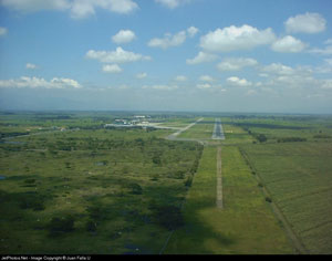
Photo copyright Juan Falla Urbina - used with permission
At 2141:15 the Ground Proximity Warning System (GPWS) message, "Terrain, terrain, whoop, whoop" was recorded on the CVR. The autopilot was disconnected and the flight crew added full power and raised the nose of the airplane to approximately a 30-degree nose-up attitude. The speed brakes (spoilers) that had been extended during the descent were not retracted. The stick shaker (stall warning) activated several times during the maneuver, indicating that the crew obtained the maximum climb angle available. However, the failure to stow the speed brakes may have made the difference in their ability to clear the terrain. The CVR ended at 2141:28 with the airplane impacting trees at 8,900 feet msl on a heading of approximately 223 degrees in a wings level attitude on the east side of El Deluvio mountain, approximately 10 miles east of the intended approach path into Cali. View American Flight 965 animation.
The airplane impacted the ground approximately 100 feet below a ridgeline of the mountain, and wreckage continued over the ridge where it came to rest and burned. Due to the extremely rugged terrain and low visibility, search and rescue operations were unable to locate and reach the crash site until the next morning. Only four of the 163 people aboard the airplane survived.
View American Flight 965 Accident Animation below:
The Controlled Flight Into Terrain (CFIT) Hazard
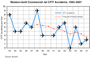
Controlled Flight Into Terrain (CFIT) has been a leading cause of accidents involving hull losses and fatalities. CFIT is defined as an event in which a normally functioning airplane is inadvertently flown into terrain, water, or an obstacle. Since the beginning of commercial jet operations, more than 9,000 fatalities have occurred worldwide in CFIT accidents. This type of accident can occur during any phase of flight but is most common during the approach-and-landing phase.
Some of the factors that increase the risk of CFIT accidents include:
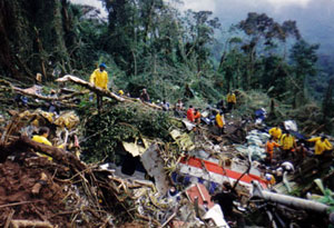
- Airport and Approach control without radar capability
- Airports located in or near mountainous terrain
- Non-precision approaches and/or shallow approach paths
- Operations other than scheduled, domestic operations
- Limited runway lighting systems
- Communication issues between pilots and controllers
- Lack of published departure procedures
- Poor weather or other adverse environmental conditions
- Pilot fatigue
- Poorly equipped aircraft or deficient CFIT training
In the case of Flight 965, the destination airport was in a valley surrounded by mountains, and the approach control radar was out of service. It was unclear to the investigation whether the flight crew realized that the approach controller did not have radar capability. The crew abandoned the precision ILS approach that had been initially planned in favor of an expedited non-precision VOR/DME approach.
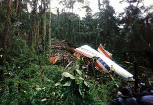
The Colombian accident report stated:
"Cali airspace differed in several critical ways from comparable airspace in the contiguous 48 states of the United States, the airspace in which the accident flight crew had accrued the overwhelming majority of their flight experience. The Cali airspace was not provided with:
- Radar coverage
- Computer software to alert aircraft deviation from a safe altitude
- Computer software to enhance the radar image of a particular flight
- A controller who shared a native language and culture with the flight crew
Because of these not insubstantial differences, unlike in domestic U.S. airspace, the Cali approach controller was entirely dependent on crew-provided information to determine the location, altitude, airspeed and climb/descent rate of a flight, and to assess whether that flight required air traffic control services beyond that provided for in the applicable rules and regulations. Consequently, in this airspace a controller's perception of the state of a flight that he or she is controlling is entirely dependent on the quality of the information that flight crew provides. Deficiencies in that information directly caused deficiencies in the controller's awareness of the situation experienced by that particular flight."
As a result, the flight crew may not have been fully aware of the potential for communication issues, and they did not properly communicate their status to the approach controller. This was viewed as a key factor in the investigation.
The weather was good. There was no moon at the time of the accident, which may have compromised the ability of the crew to see surrounding terrain. The aircraft was well-equipped with a flight management system and a Ground Proximity Warning System (GPWS). The flight crew was proficient and current in the 757, and both pilots had been qualified through a company-sponsored training program for South American operations.
The Flight Safety Foundation International CFIT Task Force released a "CFIT checklist" in 1995, as part of its international program, to aid in reducing CFIT accidents. The checklist allows evaluation of specific flight operations and can enhance pilot awareness of CFIT risk. Using this tool to quantify CFIT risk, Flight Safety Foundation CFIT checklist returns a "High CFIT risk" rating for this flight.
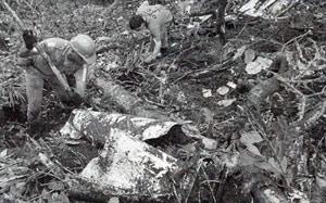
The investigation concluded that the flight crew's acceptance of an expedited approach, along with subsequent errors stemming from misuse of the Flight Management System, resulted in a breakdown of the flight crew's horizontal and vertical situational awareness. This breakdown became apparent in the cockpit with the flight crew questioning, on multiple occasions, their location and heading. However, once the fact was realized that they were not where they were supposed to be, neither flight crew member acted upon this fact, choosing instead to continue the descent and press on towards the airport without understanding the presence of terrain between their present position and the airport. Ultimately, these human errors were determined to be the probable causes of this accident as reported in the Aeronautica Civil accident report. View a copy of the Aeronautical Civil Accident Report.
Mitigating the CFIT Hazard
At the time of this accident, the CFIT hazard was well known. A number of global cooperative efforts were already in place to reduce the occurrence of CFIT accidents, especially in commercial transport operations. The Flight Safety Foundation had organized an international CFIT Task Force in 1993 that was dedicated to reducing the occurrence of CFIT accidents. At the time of the Flight 965 accident, a comprehensive CFIT Education and Training Aid had been developed by the task force, and it was scheduled to be distributed in early 1996 to provide airlines with educational video, simulator scenarios, and other training materials that could be used during recurrent pilot training. These efforts were in addition to technology advancements, such as those being applied to the Ground Proximity Warning System (GPWS), which held great promise in preventing CFIT. Early GPWS systems were prone to false alarms. There had been several CFIT accidents and incidents that involved flight crews ignoring, delaying reaction to, or not reacting appropriately to GPWS warnings. In addition, there were several accidents, including American 965, which indicated that GPWS did not provide enough advance notice of terrain to avoid an accident. In the years after the Flight 965 accident, numerous air carriers developed training videos with the goal of increasing flight crew awareness of the CFIT hazard. Although these training videos may not be completely accurate recreations of actual events, nor directly correlate with accident board's findings, they are valuable tools for mitigating the CFIT hazard. View an example of such a training video below.
GPWS Versus Enhanced Terrain Awareness and Warning Systems (TAWS)
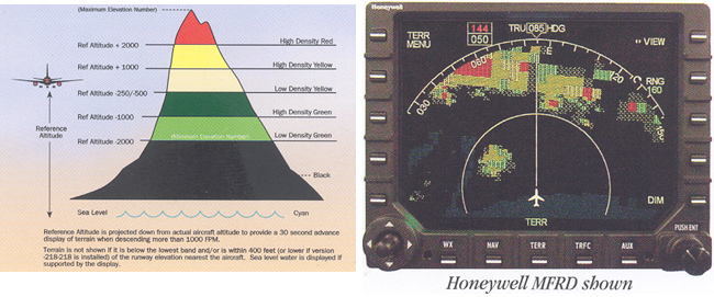
(View Larger)
In the Flight 965 accident, the GPWS terrain warning provided only 13 seconds of warning before the flight impacted the mountain ridge. The flight crew reacted immediately to the warning but neglected to retract the speed brakes that had been extended near the top of the descent. After the accident, Boeing tests were performed in an attempt to determine if the outcome would have been different had the speed brakes had been stowed. Although climb performance would certainly have improved, the manufacturer and the investigation board were unable to determine conclusively whether stowing the speed brakes would have resulted in Flight 965 clearing the mountain ridge and treetops.
Although a number of recommendations were made regarding speed brake systems and procedures, in the end it was concluded that more advanced notice of a terrain conflict was necessary to ensure successful recoveries could be affected after ground proximity warnings. This realization resulted in a push to implement Enhanced Terrain Awareness and Warning Systems in commercial aircraft. One such system, the Enhanced Ground Proximity Warning System (EGPWS), utilizes present position information from the aircraft's Global Positioning System (GPS) or FMS, groundspeed information, and a terrain database to allow EGPWS to "look-ahead" to provide terrain awareness, terrain alerts, and warnings to the flight crew. Enhanced Terrain Awareness and Warning Systems are now mandatory equipment in turbine-powered air carrier operations in the U.S. and many other countries and have resulted in a significantly reduced CFIT accident rate worldwide.
Other Mitigations
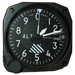
The continued advancement of aviation technology, including the advent of "glass cockpits," heads-up displays, moving maps, and the integration of the global positioning system (GPS), has provided precision navigation capabilities and situational awareness previously unavailable in transport aircraft operations. This increase in capability and automation has all but phased out some systems such as the "three-pointer" and "drum-pointer" altimeters which were long associated with increased CFIT risk due to their tendency to be misread during critical phases of flight. Additionally, advances in approach charts have seen the addition of colored topographical information in order to increase the situational awareness of pilots operating in mountainous terrain. Vertical Situation Displays (VSDs) are being added to modern cockpits, which can greatly improve a flight crew's awareness of vertical flight path and surrounding obstacles and terrain. Integrated Approach Navigation (IAN) technology has also been developed, which allows the use of "non-precision" approach and landing aids to provide glide path information that mimics the precision glide slope guidance provided by traditional instrument landing systems. This capability greatly simplifies, and allows stabilization on, non-precision approaches by providing a near-standardized descent to the runway. Synthetic and Enhanced Vision systems continue to be developed and introduced into service to allow flight crews to "see" terrain and other obstacles that would otherwise be obscured by weather or light conditions.
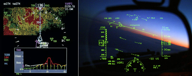
Right: Heads Up Navigation Display on 737-800 - Copyright Brett B. Despain - used with permission
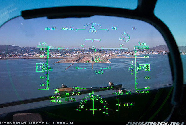
Photo copyright Brett B. Despain - used with permission
The accident was investigated by the Colombian Aeronautica Civil. Eighteen findings were issued covering a variety of subjects. The most pertinent findings were related to the flight crew's confusion during the approach and lack of knowledge regarding proper identification of approach fixes. The complete text of the findings, including the probable cause and contributing factors, is available at the following link: Findings
As a result of this accident, Aeronautica Civil issued 22 recommendations: 17 to the FAA three to the International Civil Aviation Organization (ICAO), and two to American Airlines. The recommendations to the FAA dealt variously with flight deck displays, flight management system (FMS) data retention, presentation of accurate terrain information, crew procedures, and crew training. The recommendations to ICAO concerned standard radio terminology and phraseology, adoption of recommendations relative to avoidance of controlled flight into terrain (CFIT), and criteria for electronic navigational databases. The recommendations to American Airlines concerned flight crew training.
The complete text of the recommendations issued by Aeronautica Civil is available here: Recommendations
The National Transportation Safety Board (NTSB) also made a number of recommendations relative to this accident. The 17 NTSB recommendations primarily addressed automatic retraction of speed brakes and procedures regarding speedbrakes, terrain avoidance, navigation, and approach criteria. The NTSB recommendations are available here: NTSB Recommendations
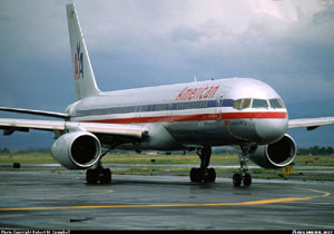
on the ground at Mexico City in 1995
Photo copyright Robert M. Campbell - used with permission
The flight crew of Flight 965 had a preponderance of experience operating in the confines of U.S domestic airspace. This experience included:
- Nearly constant radar coverage
- Communication in English as the primary language of flight crews and controllers
- A high availability of navigation aids and precision approaches
In contrast, the environment for Flight 965 in Colombian airspace was more challenging given the lack of radar surveillance, execution of a non-precision approach, and the difference in primary language between the flight crew and the approach controller. All these factors created difficulty in establishing and maintaining appropriate flight crew situational awareness and prevented the timely recognition by the flight crew of Flight 965's flight path deviations that led to the accident.
- Speed brakes would be retracted during a GPWS escape maneuver.
- Flight crews will understand and properly execute instructions from air traffic controllers.
While there are differences in the two accidents, an Air Inter A320 accident at Strasbourg, France in January 1992 can be viewed as a precursor to American Airlines Flight 965. While on approach to Strasbourg at night, the Air Inter crew accepted a runway change to expedite their approach and landing. While setting up for the approach, an error was made in selection of an autoflight mode, and the approach path became too steep. This anomaly apparently went unnoticed by the crew, and the airplane impacted the ground 10.5 miles short of the runway.
Although the Air Inter A320 was equipped with GPWS, it was not operational. This accident can be considered a precursor as it involved a short notice change of runway that required the crew to make last minute changes to the approach planning and the use of autoflight and navigation systems in a high workload segment of the flight. Flight deck mode confusion was found to be a factor in the event, as was a lack of proper flight deck discipline and cockpit resource management (CRM) skills.
See accident module
14 CFR 121.354 (Terrain Awareness and Warning System)
The following links provide information about Terrain Awareness and Warning Systems.
View below for the EGPWS functions animation:
View below for the terrain display animation:
The accident was attributed almost exclusively to crew error (view Accident Board Findings). Since no unsafe condition or design flaw was implicated, there was no basis for AD action relative to 757.
Relative to the findings of the inadequacy of Ground Proximity Warning Systems to provide timely warning in the case of imminent terrain collision, a fleet-wide initiative was begun following this accident that culminated in the issuance of a retroactive operational rule requiring the installation of a Terrain Awareness Warning System in the U.S. commercial fleet.
Airplane Life Cycle:
-
Operational
Accident Threat Categories:
- Flight Deck Layout / Avionics Confusion
- Crew Resource Management
Groupings:
- Controlled Flight Into Terrain
- Approach and Landing
- Automation
Accident Common Themes:
- Human Error
Human Error
The flight crew of Flight 965 made three significant errors in navigating towards the airport in Cali, and in their crew resource management (CRM) practices, while attempting to accomplish an expedited approach at night in mountainous terrain. The crew:
- Did not follow air traffic control instructions (report at Tulua VOR)
- Incorrectly programmed the flight management computer (inputting "R" and mistakenly believing it to be the identifier for "ROZO")
- Failed to recognize a lapse in situational awareness
High workload and a loss of situational awareness put them in a position where prudent action should have caused them to abandon the approach and recover to a safe altitude. While discussing their apparent difficulties in placing the airplane in three-dimensional space, they continued the approach, compounding their errors and eventually leading to the crash.
Air Inter A320, Strasbourg, France, January 20, 1992
While approaching an airport surrounded by mountainous terrain at night, the crew of the Air Inter A320 was offered, and accepted, a change in runway to expedite their arrival at the gate.
In the aftermath of rapidly reprogramming the flight deck automation during a high workload phase of flight, the airplane impacted terrain 10.5 miles from the runway. Eighty-two passengers and five crew members died in the accident. The probable cause of the accident was attributed to the flight crew having inadvertently selected the vertical speed (VS) mode rather than flight path angle (FPA) and mistakenly input a vertical speed of 3,300 feet per minute rather than an FPA of 3.3 degrees during the final segment of the approach.
Among the contributing factors were:
- Autopilot mode confusion on the part of the crew
- Crew input error to the autoflight system
- Improper mode selection (VS verses FPA) or improper mode value (3.3 verses 3,300) input
- Lack of awareness of the airplane's vertical speed on the part of the flight crew
- Lack of the crew's adherence to established instrument approach procedures in performing checks of the altitude, distances, and aircraft automation
- Lack of communication on the part of the crew
- Improper use of crew resource management (CRM)
- Design of the autoflight system controls and the resultant potential for mode confusion and input errors
- Late change of instrument approach selection
- High crew workload resulting from the change of approach procedure late in the terminal phase of the flight
See accident module
Technical Related Lessons
Any flight deck device/system used for alert and avoidance of an aeronautical hazard must be designed to provide adequate and unambiguous notice of the impending hazard to allow appropriate crew response under all expected flight conditions. (Threat Category: Flight Deck Layout/Avionics Confusion)
- At the time of the Flight 965 accident, the first-generation Ground Proximity Warning System installed in the aircraft was limited in its ability to warn the flight crew of impending Controlled Flight Into Terrain (CFIT). Early Terrain Warning technology relied only on radar altimeter, airspeed, and rate of descent inputs to determine unsafe closure rates to terrain below the aircraft. This technology did not always provide sufficient "early warning" cues to allow the flight crew's response to the warning and avoid the conflict. Terrain Awareness and Warning Systems (TAWS) now utilize present position, track, groundspeed, and a digital terrain database to display potentially dangerous terrain and provide timely terrain warnings and commands to the flight crew.
Early recognition of lost situational awareness is vital to safety of flight. Flight crews must be trained in strategies to retain situational awareness as well as immediate initiation of escape and recovery strategies when situational awareness has been lost. (Threat Category: Crew Resource Management)
- The flight crew of Flight 965 continued to descend and focused on efforts to salvage their approach despite being unable to fix their location with respect to the cleared arrival course, and after realizing that they were experiencing a large discrepancy between their intended and actual heading. By failing to clearly communicate within the cockpit, and to air traffic control, that they had made an error and were off course, the crew lost an opportunity to reconsider their original course of action and fly the aircraft to a safe altitude.
Common Theme Related Lessons
Task saturation can lead to a catastrophic degradation in situational awareness. Expedited approaches should not be accepted in night or in instrument meteorological conditions without determining if sufficient time is available to complete all critical tasks (Common Theme: Human Error)
- In the case of Flight 965, the decision by the flight crew to accept the expedited approach to the southbound runway compounded several errors and circumstances that diminished the flight crew's situational awareness. Since insufficient time was available to properly perform all the critical approach tasks, the flight crew was ill-equipped to recognize and respond properly to a critical error that had led their aircraft away from the intended flightpath and over mountainous terrain.
