
Oakland San Francisco Bay Airport (OAK)
Oakland San Francisco Bay Airport (OAK) is a multi-use airport located on the east side of San Francisco Bay, ten miles northeast of the San Francisco International Airport and just south of the city of Oakland, California. The traffic mix consists of all aspects of the aviation community. Most general aviation services are located on the north side of the airport. View a printable Pilot Handbook of the OAK information found on this Web page.
Know Before You Go
OAK ATCT: Operates 24 hours
Administrative Office: Open 0800L to 1600L M-F
Business Phone: 510-214-1700
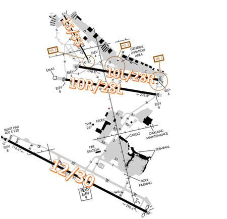
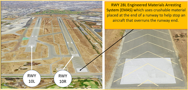
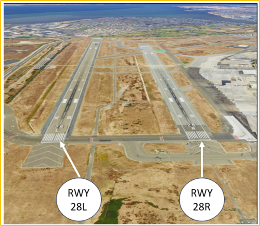
The RWY configuration consists of parallel RWYs 10R/28L and 10L/28R, RWY 15/33, and the larger RWY 12/30.
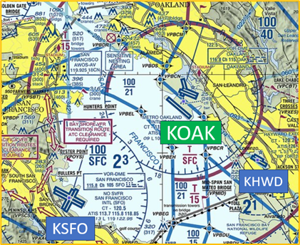
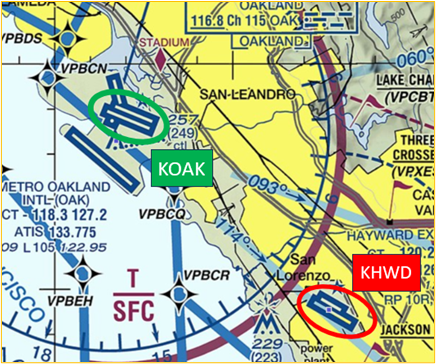
The airspace at OAK is Class C and underlies San Francisco Class B. (See sectional chart)
Hotpots
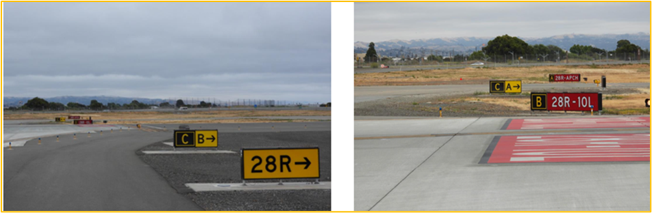
HS 1: TWY A and TWY B both cross RWY 28R. Pilots sometimes mistake TWY A for TWY B, and vice versa. Verify correct taxi route.
- Hotspot 1 is located at the approach end of RWY 28R and TWY B. Two issues occur at this location.
- Pilots, instructed to taxi via TWYs C/B, sometimes miss the hold short markings and signage for RWY 28R and enter RWY 28R without authorization.
- The other issue concerns pilots taxiing on TWY C, missing the turn onto TWY B, continuing and turning onto TWY A and crossing the approach hold short line. This can lead to a conflict with traffic landing on RWY 28R.
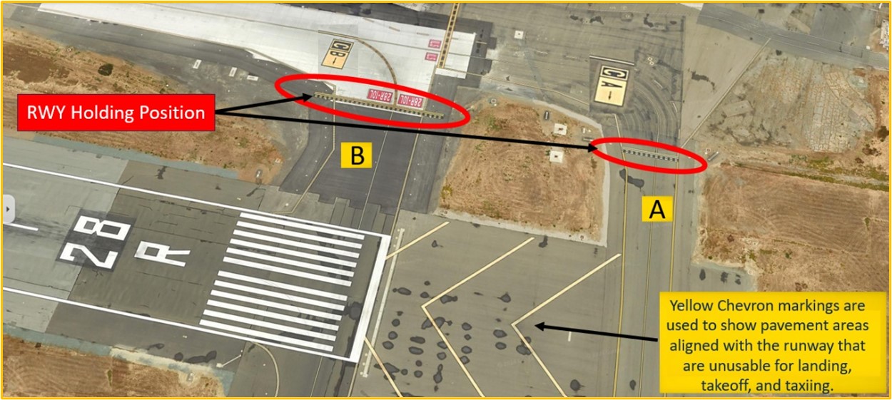
- Above ground signage, wig-wag lights and surface painted markings are present to assist pilots taxiing in this area (see pictures below).
- For all of the OAK Hotspots, actively scanning to locate and identify RWY signs, markings, lighting and deferring all heads down activities until holding short at the appropriate location will help eliminate these errors.
- Verify with the TWR when you are unsure whether to hold or proceed.
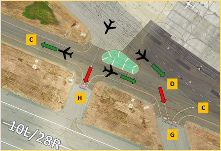
HS 2: Aircraft departing the ramp sometimes miss their turn onto TWY C or TWY D, mistakenly proceeding onto TWY H or TWY G and ultimately RWY 10L/28R.
- Hotspot 2 concerns the large concrete area where TWYs C/D/G/H come together.
- This issue involves aircraft exiting the FBO ramp with instructions to taxi via TWYs H/C, missing TWY C and continuing onto RWY 10L/28R.
- Additionally, aircraft instructed to taxi via TWYs D/C have also missed a slight left turn onto TWY C and continued across TWY C to TWY G and onto RWY 10L/28R.
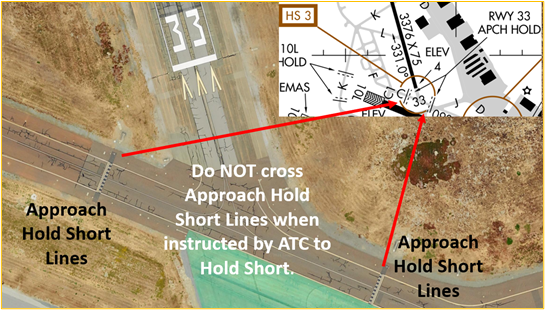
HS 3: Runway Incursion Risk. TWY C between TWY C1 and TWY J. Approach Hold in effect when instructed by ATC.
- Pilots should review NOTAMS for Letter to Airmen: LTA-OAK-2 - Runway Incursion Risk at Hot Spot #3 for facility issued guidance.
Wrong Surface Landing Risk
- Wrong Surface Landing risk exists due to closely spaced parallel RWYs with staggered thresholds.
- If available, back up all visual approaches with an instrument approach to help ensure that you are lined up for the correct surface.
- View the From the Flight Deck-Wrong Surface Landings video for additional mitigation strategies.
Wrong Airport Landing Risk
See Arrival Alert Notices (AAN)
- The parallel RWYs at OAK are similar to those at HWD (six miles southeast) and this has led to wrong airport alignment issues.
- During pre-flight planning, check the sectional chart for airports in close proximity and charted reporting points.
- Use navigational aids such as GPS, localizers, or VOR radials to positively identify the airport.
- View the From the Flight Deck-Wrong Airport Landings video for more information and mitigation strategies.
General
- Aircraft landing/departing RWY 30 or approaching OAK Class C airspace from the south will contact tower on frequency 127.2. Aircraft landing/departing RWY 28R/L and RWY 33 or approaching the Class C from the north will contact tower on frequency 118.3.
- VFR reporting points to be familiar with when operating in or near OAK airspace:
- Lake Chabot
- Mormon Temple
- Oakland Coliseum
- Interstate 880 and 580
- Midspan San Mateo Bridge
- When approaching OAK, use caution for traffic at 1000’ in the right closed traffic pattern on RWY 28R.
- Oakland Airport has a voluntary noise abatement program from Monday-Saturday between 2200L-0700L and Sundays between 2200L-0800L. The Oakland Airport Authority prefers that jets depart RWY 30.
Traffic Pattern
- When on the right downwind, if you are tracking the 880 freeway, this will encroach on the arrival corridor for RWY 28R/L.
- RWY 28L pattern work must be conducted north of the control tower for wake turbulence separation and to not trigger TCAS Resolution Alert with RWY 30 IFR operations.
- Pattern altitude for RWY 28L is 600’. Pattern work for RWY 33 may be restricted north of RWY 28R for landing/departing traffic.
- When your right crosswind-turn from either RWY 28R/L conflicts with an inbound aircraft, you may be instructed to fly towards downtown Oakland.
VFR Transitions
- When transitioning north/south through the OAK Class C airspace, expect to be routed over the RWY 30 numbers and the Oakland Coliseum at 2000’.
- When transitioning east/west, expect to follow the I-880 freeway or to remain north of Lake Chabot (depending on direction of flight).
- When OAK is landing and departing RWY 12 and RWY 10R/L, plan to transition through HWD’s Class D airspace.
Ground Control
- When departing VFR, expect to receive a discrete beacon code and altitude restriction based on direction of flight on initial contact with Ground Control (GC) on 121.9.
- There are no defined run-up areas at OAK for the north field runways. Run-ups are generally conducted on TWY C between TWY B and TWY A and on TWY J. Request run-up location with GC.
- Due to airport layout, use caution when exiting RWY 28R at TWY J or taxiing in proximity to RWY 33 at TWY C for an increased risk of runway incursion. Review NOTAMS for LTA-OAK-2 “Runway Incursion Risk at Hot Spot #3”.
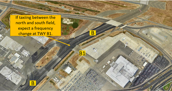
- When taxiing between the North and South Fields, hold short of TWY B1 unless instructed otherwise.
- When taxiing out of Signature or Kaiser FBO ramps, use caution not to enter RWY 10L/28R at TWY G or TWY H (see Hotspot 2).
- When leaving the “Old T” hangars, be aware TWY F leads to RWY 15 and RWY 33. Make sure to comply with the assigned taxi route.
- We have two GC frequencies at OAK: 121.75 for the south field and 121.9 for the north field. If taxiing between the north and south field, expect a frequency change at TWY B1.
Take-off/Departure
- When departing RWY 28R full length, verify that you are at TWY B. RWY 28R is not accessible from TWY A (see Hotspot 1).
- When departing RWY 28R/L VFR or IFR on the NIMI5 SID, be aware that extending upwind will conflict with the RWY 30 departure corridor.
- When you are departing RWY 30 with a controlled release time, brief the numbers for a TWY W2 departure with 9,600’ remaining in the event that TWY W1 is blocked by other aircraft in sequence for departure.
Arrival/Landing
- When on approach to RWY 28R/L and RWY 30, use caution for traffic in the vicinity of HWD airport.
- When landing RWY 10R continue taxiing to TWY B due to weight restrictions of 12,500 lbs. or less on TWY H and G.
- Northern California TRACON provides standard IFR separation to VFR aircraft conducting practice instrument approaches at OAK. Review NOTAMS for the Letter to Airmen LTA-NCT-96 “IFR Separation for VFR Aircraft Practicing Instrument Approaches” for more information.
- When exiting RWY 28L at TWY J, do not accidentally turn onto TWY K which is not rated for more than 33,000 lbs. for single wheel and 45,000 lbs. for dual wheel.