
Willow Run Airport (YIP)
Willow Run Airport (YIP) is a general aviation airport located on the eastern edge of the city of Ypsilanti, Michigan, and approximately eight miles west of the Detroit Metro Wayne County Airport (DTW). YIP serves local and transient general aviation, business, air taxi and military operations. A complex taxiway system provides access to all businesses including the FBO and ramp areas which are in all four quadrants of the airport. View a printable Pilot Handbook of the YIP information found on this Web page.
Know Before You Go
YIP ATCT Operates: 24 hours
Administrative Office: Open 0730L to 1700L M-F
Business Phone: 734-961-6845
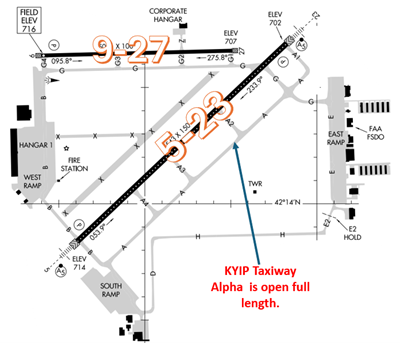
The airport configuration consists of RWY 5/23 and RWY 9/27.
The airspace at YIP is Class D and underlies Detroit Class B airspace (Refer to Sectional Chart)

Wrong Surface Landing Risk
See Arrival Alert Notices
- Whenever a taxiway runs parallel to a runway, the risk of landing on a taxiway increases.
- Due to the close proximity and parallel orientation of TWY G to RWY 27, pilots are urged to exercise heightened caution during approaches.
- RWY 27 is paved in asphalt and appears darker than TWY G.
- To help mitigate the risk of wrong surface landings, Tower will keep the lighting on RWY 27 activated at all times.
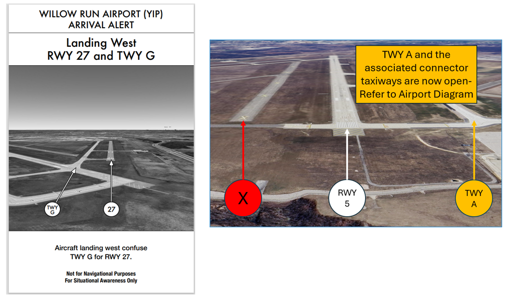
- Another potential Wrong Surface Risk is a former runway that is closed, marked with a series of X’s, that lies just north of RWY 5.
- If available, back up all visual approaches with an instrument approach/GPS Waypoint to help ensure that you are lined up for the correct surface.
- Remember, RWY markings are white. Markings on surfaces not used for takeoff/landing like TWY markings, chevrons, RWY shoulder and RWY turn-on markings etc., are yellow.
- If you are unsure of your position or instructions, ask the controller.
- View the From the Flight Deck-Wrong Surface Landings video for additional mitigation strategies.
General
- Read back all runway assignments and hold-short instructions with callsign.
- Be advised that some FAA charts and publications may not yet depict TWY A as open full length. Until such time as these publications are updated, exercise caution when taxiing in the vicinity of TWY A. Pilots should review NOTAMS for the Letter to Airmen: LTA-YIP-3 Taxiway Alpha - Full Length Open for specific information.
Traffic Patterns
- TWR will assess the current hourly winds and based upon them they will conduct either left or right traffic on RWYs 5/23 and/or RWYs 9/27.
- Please fly a standard traffic pattern in accordance with the AIM and the FAA Airplane Flying Handbook unless otherwise approved or directed by the controller.
- Request early turns and non-standard traffic patterns from the controller.
Ground Control (GC)
- Contact YIP GC on 119.975. This position also monitors Clearance Delivery on 118.175.
- YIP east, west, and south ramps are uncontrolled. All aircraft must contact GC for instructions to enter any active taxiway.
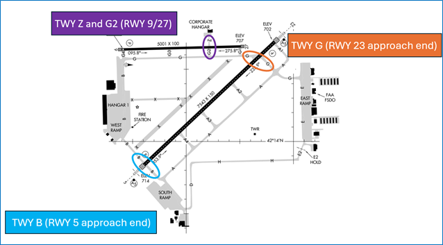
Runway Crossings
- RWY crossings take place at three locations:
Takeoff/Departure
- TWR frequency is 125.275 (VHF) and 256.9 (UHF).
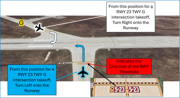
- When YIP is departing RWY 23, intersection takeoffs at TWY G are available upon request.
- When pattern work is being conducted on RWY 9/27, departing RWY 23 from TWY G will be the most expeditious (upon request).
- Distance remaining on RWY 23 at TWY G intersection is 6,700 ft.
- At an intersection, the white numerical RWY Designators may not be visible. Use the red RWY Holding Position markings/signs to identify the RWY.
- Before entering the RWY and when lined up on the RWY, check the Magnetic Compass and the Horizontal Situation Indicator (HSI), if installed, to verify that the aircraft is pointed in the correct direction.
Arrival/Landing
- Detroit Approach will, when possible, provide IFR longitudinal separation and/or a minimum of 500 feet vertical separation to VFR aircraft practicing instrument approaches to tower-controlled airports within Detroit Approach Control Airspace.
- Pilots should review NOTAMS for the Letter to Airmen: LTA-D21-36 VFR Practice Instrument Approaches for specific information.
Special Traffic (Military / Commercial / Helicopter, etc.)
- Helicopter takeoffs and landings are prohibited on the south ramp.