Kenai Flight Service Station
Tuesday, December 30, 2025470 N. Willow St.
Kenai AK, 99611-7707
Air Traffic Manager:
Lucas Barnlund
Facility Information
Sources and Information Sources Used by Briefers
- Satellite Facilities
- Phone Numbers
- Preflight Planning
- Standard Weather Briefing
- Abbreviated Briefing
- Outlook Briefing
- Flight Plans
- Kenai FSS Frequency Card (PDF)
- Inflight Weather Briefing
- Area Forecasts (FA)
- Current Weather Reports (METAR/SPECI)
- Terminal Aerodrome Forecasts (TAF)
- Wind & Temperature Aloft Forecasts (FD)
- Inflight Advisories (WS, WA, CWA)
- Pilot Reports (UA)
Satellite Facilities
Responding to user requests, several FSSs in south central and southwestern Alaska remain open--staffed primarily by specialists from the Kenai FSS on a rotational basis. The following satellite facilities are generally open during regular business hours and are remotely operated by Kenai FSS at night.
- Cold Bay FSS: 8:00 am to 5:45 pm
- Dillingham FSS: 7:45 am to 9:45 pm
- Homer FSS: 6:00 am to 9:30 pm
- Iliamna FSS: 5:45 am to 9:45 pm (June 01 to September 30)
- McGrath FSS: 9:00 am to 6:45 pm (June 15 to September 30)
- Palmer FSS: 8:00 am to 6:00 pm
- Talkeetna FSS: 8:00 am to 5:45 pm (September 15 - April 14)/
- 8:00 am to 8:00 pm (April 15 - September 14)
Kenai FSS Hub Flight Plan Areas
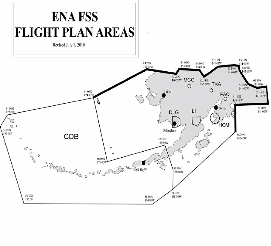
- PAQ, TKA, and MCG Flight Plan Areas (FPA) consist of a five nautical mile radius circle surrounding their respective airports during the hours the facilities are open.
- HOM Flight Plan Area consists of a 30 nautical mile radius circle surrounding the airport during the hours HOM is open.
- ILI Flight Plan Area is defined by coordinates 59°40′N/156°00′W to 60°05′N/155°00′W to 59°50′N/153°20′W to 59°30′N/154°00′W to 59°10′N/156°00′W to 59°40′N/156°00′W.
- DLG Flight Plan Area is defined by coordinates 60°00′N/158°30′W to 59°45′N/157°15′W to 59°00′N/157°15′W to 58°33′N/158°30′W to 58°33′N/159°30′W to 59°00′N/159°30′W to 60°00′N/158°30′W.
- The appropriate FSS hub facility shall assume FPA responsibility when FSSs are closed.
Pilot Weather Briefing Phone Numbers
- Kenai/Soldotna and Vicinity: 907-283-7211
- Toll Free: 1-866-864-1737
- Toll Free: 1-833-252-7433 (AK-BRIEF).
Preflight Planning
A good weather briefing starts with developing an awareness of the overall “big picture” before attempting to get a detailed weather briefing. A good source for Aviation Weather products is the Alaska Aviation Weather Unit (AAWU) webpage.
At many locations, you can learn about the "big picture" by listening to the National Oceanic and Atmospheric Administration (NOAA) Weather Radio, Television and Radio Weather Broadcasts, and newspaper weather maps.
When you are ready to call for a weather briefing, make sure your planned route of flight is worked out and your flight plan partially completed before you make the telephone call. So that your briefing can be tailored to your needs, give the briefer the following information:
- Type of weather briefing requested: Standard, Abbreviated, or Outlook
- Type of flight contemplated: VFR or IFR
- Aircraft's N-number or pilot's name
- Type of aircraft
- Departure point
- Proposed route of flight
- Destination
- Proposed flight altitude(s)
- Estimated time of departure (ETD)
- Estimated time en-route (ETE) or Estimated time of arrival (ETA)
After the conclusion of the briefing, if there is anything that you do not understand about the weather briefing, let the briefer know. If terminology is used that you do not understand, ask the briefer to explain it. A briefer who talks too fast should be asked to speak more slowly. The amount of detail in your weather briefing will depend upon how complicated the weather situation really is. Remember, if the weather situation really is “iffy,” expect and insist upon a standard weather briefing; it is both your legal responsibility and your prerogative.
Preflight Planning (by Phone)
Kenai FSS's site-specific toll-free number is 1-866-864-1737. The nationwide toll-free number for Automated Flight Service Stations is 1-833-AK-BRIEF (1-833-252-7433). You will normally be automatically connected with the FSS that serves the area from which you are calling, providing you with direct access to recorded weather, aeronautical information, and flight plan filing. When you reach the FSS, you will be answered by a recorded announcement which includes the name of the facility followed by instructions for connecting with a Pilot Weather Briefer. While both touch-tone and rotary phones are supported, you will be automatically switched to a briefer if calling from a rotary phone. At the conclusion of each service, you may hang up, select another service, or you may access a pilot weather briefer by pressing the (1) key. Pressing the (3) key will direct your call to our Fast File Flight Plan Services. The Fast File Flight Plan Services can be used to file IFR or VFR flight plans, close a flight plan, or record a pilot weather report. Please speak slowly and distinctly into the telephone and provide complete data, as we may not be able to call you back. Like the TWEBs, TIBS recordings are updated 24 hours a day. Fast File and weather briefers are also available 24 hours a day. Pressing the (8) key directs you to additional instructions on the usage of the system. Only one service can be accessed at a time. You may interrupt a recorded message at anytime by pressing the (1) key to transfer to a briefer.
Important Points to Remember:
- Always wait for a ringing tone before entering access codes.
- To interrupt recorded messages use the (1) key to transfer to a briefer.
- To avoid waiting for a briefer, you can go directly to FAST FILE to file IFR or VFR flight plans, close your VFR flight plan, or submit a pilot weather report (PIREP) by pressing 3.
- If you accidentally enter an incorrect access code re-enter the desired code after a new tone is received.
- If no command is received for eight seconds you will be automatically be connected to the next available briefer.
- After using TIBS or FAST FILE you can always go back to a pilot weather briefer for additional information.
- If on rotary or pulse dial phone remain on the line. You will be automatically connected to the next available briefer.
Standard Weather Briefing
If you request that the briefer provide you with a Standard Weather Briefing, the briefer will be following procedures and phraseology used by FAA personnel providing flight services. Specialists are directed not to read weather reports verbatim unless you specifically request they do. At a minimum, your preflight briefing will include the following elements:
- Adverse Conditions:
- The briefer will advise you of any significant meteorological and/or aeronautical information (e.g., thunderstorms, icing, turbulence, low ceilings or visibilities, airport closures) along your proposed route of flight that might influence you, the pilot, to alter or cancel your proposed flight. Expect the briefer to emphasize conditions that are particularly significant, such as low level wind shear, embedded thunderstorms, reported icing, or frontal zones. When a VFR flight is proposed and actual or forecast conditions make VFR flight questionable, the briefer will describe the conditions and may advise you “VFR flight is not recommended.” If this occurs, or if you feel that the weather conditions are clearly beyond your capabilities you should consider terminating the briefing. This will free the briefer to handle other incoming calls. Of course the GO/NO-GO decision is up to you, the pilot-in-command.
- Synopsis:
- A brief statement as to the cause of the weather (e.g., fronts or pressure systems) which might affect your proposed route of flight.
- Current Conditions:
- When your proposed time of departure is within two hours, the briefer will summarize current weather, including PIREPs, applicable to your route of flight.
- Enroute Forecast:
- Expect the briefer to summarize forecast conditions along your proposed route in a logical order, i.e., climb-out, enroute, and descent.
- Destination Forecast:
- The destination forecast for your planned ETA will be provided, including any significant changes within one hour before and after your planned time of arrival.
- Winds Aloft Forecast:
- The briefer will summarize forecast winds aloft for the proposed route. Temperature information will be provided on request.
- Notice to Airmen (NOTAMs):
- Current NOTAMs pertinent to your proposed route of flight will be provided.
- The following information is available on request:
- Military Training Routes and Areas (MTRs and MOAs)
- Published NOTAMs and Special Notices
- Request for Pilot Reports:
- Due to the mountainous terrain and scarcity of weather reporting stations in Alaska, the briefer will request that you provide pilot reports for enroute conditions.
Abbreviated Briefing
Request an abbreviated weather briefing when you need information to supplement mass-disseminated data, update a previous briefing or when you need only one or two specific items. Provide the briefer with appropriate background information, the time you received the previous information, and/or the specific items needed. You should indicate the source of the information already received so that the briefer can limit the briefing to the information that you have not received, and/or appreciable changes in meteorological conditions since your previous briefing. To the extent possible, the briefer will provide the information in the sequence shown for a Standard Briefing. If you request only one or two specific items, the briefer will advise you if adverse conditions are present or forecast. Details on these conditions will be provided upon your request.
Outlook Briefing
You should request an outlook weather briefing whenever your proposed time of departure is six or more hours from the time of the briefing. The briefer will provide available forecast data applicable to the proposed flight. This type of briefing is provided for planning purposes only. You should obtain a Standard Weather Briefing prior to departure in order to obtain such items as current conditions, updated forecasts, winds aloft and NOTAMs. If you need an outlook briefing for conditions three or more days in the future, contact the National Weather Service Forecaster.
Flight Plans
If, after having received a briefing, you decide to go, please file a flight plan. One thing you can do to simplify your flight plan filing is to put your aircraft and personal information on file here at Kenai FSS. The Master Flight Plan program was established for the owners/operators of aircraft in Alaska. A master flight plan is intended to record static information on an aircraft, not on a pilot. Only one master flight plan, therefore, will be accepted per aircraft from the owner/operator. Master flight plan files are maintained by FSSs for aircraft based within their respective area of responsibility, or Hub area. A master flight plan on file with any Alaskan Region FSS will be accepted by all Alaskan Region FSSs. Aircraft owners/operators may file a Master Flight Plan with an FSS in person, via mail, email, phone, fax, or radio. FSSs will forward master flight plan information to the appropriate hub FSS. Upon receipt of master flight plan information, the FSS enters the information into their master flight plan file. You may begin to use your master flight plan after receiving notice that it has been entered into the FSS's master flight plan file.
Note: Aircraft owners/operators are responsible for ensuring the master flight plan information on file for their aircraft is current. Changes in master flight plan data should be reported to the appropriate facility immediately. Failure to provide updated information could cause unnecessary delays in search and rescue activities. Pilots who do not update master flight plan information may be excluded from the program.
Just a thought about Local Area Flight Plans: If you file a flight plan for the local area, i.e. within a 25 mile radius of the airport of departure; and should become overdue, then the ratio of aircraft size to search area size is 1 to 145,167,050. Try to be as specific as possible when describing your route of flight. This will reduce the initial search area greatly.
Inflight Weather Briefing
You are encouraged to obtain your preflight briefing and file flight plans by telephone, or in person, before departure as this will reduce congestion on the radio frequencies. During normal daily operations the specialists at the Kenai FSS Inflight positions are monitoring from 12 to over 40 frequencies. When traffic is high, it is not uncommon to have five or more aircraft calling simultaneously for services. We do our best to handle all of these requests as rapidly as possible and your cooperation is requested. In addition, our frequency outlets extend from the Copper River Basin to the Alaska Peninsula and from the Alaska Range to southern Kodiak Island. Therefore, when calling Kenai via the radio, identify not only yourself, but also the radio outlet over which you are calling. In those cases where you need to obtain a preflight briefing, or an update to a previous briefing by radio, you should contact the nearest FSS/FSS to obtain this information. After communications have been established, advise the specialist of the type of briefing you require: Standard, Abbreviated, or Outlook, and provide appropriate background information. You will be provided information as specified in the above paragraphs, depending upon the type of briefing requested. Feel free to ask for any information that you or the briefer may have missed. It helps to save your questions until the briefing has been completed. This enables the briefer to present the information in a logical sequence, and reduces the chance of important items being overlooked. Enroute and destination weather updates are also available by listening to the Automatic Terminal Information Service (ATIS), Aerodrome Flight Information Service (AFIS), on-site contract weather observers (i.e. GKN), and/or monitoring the appropriate automated weather observation.
Centers and terminal area facilities broadcast a SIGMET or CWA alert once on all frequencies upon receipt. To the extent possible, centers and terminal area facilities will issue pertinent information on weather and assist pilots in avoiding hazardous weather areas, when requested.
The FAA Alaskan Region has developed a Common Traffic Advisory Frequency (CTAF) program. The purpose is to provide both aircraft and vehicular traffic a common frequency for use when operating on an uncontrolled airport. Use of the CTAF is highly recommended. Feel free to contact the tie-in FSS for current runway and NOTAM information before switching to the CTAF. If you operate into or out of an airport and find the field condition hazardous or different than reported please advise the tie-in FSS. The information you provide will be forwarded to appropriate airport management and other pilots as unofficial aeronautical information (U).
Weather Information Sources Used by Briefers
Briefers draw from all available weather sources and other aeronautical information to summarize data applicable to the proposed flight.
Area Forecasts (FA)
Area Forecasts are 12-hour aviation forecasts plus an 18-hour categorical outlook giving general descriptions of cloud cover, weather conditions, and potentially hazardous weather which could impact aircraft operations. Alaskan Area Forecasts, each covering a broad geographical area are issued four times a day (6 am, noon, 6 pm, & midnight local time.)
Heights of cloud bases, tops, freezing level, icing and turbulence are referenced to mean sea level (MSL) unless otherwise stated. Ceilings are given in heights above ground level (AGL). The causes of LIFR, IFR or MVFR are indicated by either ceiling or restrictions to visibility, or both. If sustained surface winds of 20 knots or greater are forecast for the outlook period, the word WIND is included. Example: IFRCIGRAWND: Expect an IFR ceiling below 1,000 feet AGL and rain; the surface wind is expected to be a sustained 20 knots or greater.
- Terminology (Non-Convective)
- TEMPO - More than 50% probability of occurring, but for less than half of the period.
- LCL - Conditions forecast to occur in less than 25% of the forecast area.
- ISOL - Less than 3,000 square miles or widely dispersed.
- Terminology (Convective)
- VCNTY - 5 to 25 nautical miles beyond the center of the runway complex.
- ISOL - Less than 3,000 square miles or widely separated in time.
- LCL - Less than 25% of the area affected.
- AREAS - 25-54% of the area affected.
- WDSPRD - More than 55% of the area affected.
- Outlook
- LIFR - (Low IFR) Ceiling less than 500 feet and/or visibility less than 1 statute mile.
- IFR - Ceiling 500 feet to less than 1,000 feet and/or visibility 1 to less than 3 miles.
- MVFR - (Marginal VFR) Ceiling 1,000 to 3,000 feet and/or visibility 3 to 5 miles.
- VFR - Ceiling greater than 3,000 feet and visibility greater than 5 statute miles.
METAR (Meteorological Aviation Routine Weather) and SPECI (Unscheduled Special Observation) Reports.
These reports have replaced what were known as Record, Record Special, and Special observations (SAs, RSs, and SPs). The major changes are in the order that the elements are reported and the use of ICAO identifiers for the Weather and Obstructions to vision field. Temperatures and dewpoints are now reported in Celsius. The order of fields is as listed:
- TYPE OF REPORT
- STATION IDENTIFIER
- DATE AND TIME OF REPORT
- REPORT MODIFIER
- WIND
- VISIBILITY
- RUNWAY VISUAL RANGE
- WEATHER AND OBSTRUCTIONS TO VISION
- SKY CONDITION
- TEMPERATURE/DEWPOINT
- ALTIMETER
- REMARKS
Example:
METAR PAEN 121848Z 22010KT 6SM BR SCT055 BKN080 01/M01 A2987
Terminal Aerodrome Forecasts (TAF)
Aerodrome forecasts are issued for specific airports and generally cover a 5-nautical mile radius from the center of the runway complex. Alaskan TAF Forecasts are issued four times a day (0000Z, 0600Z, 1200Z, 1800Z.) Each forecast is amended according to prescribed criteria They contain information about expected ceilings, cloud heights and coverage, visibility, weather, obstructions to vision, and surface winds. They are valid for a 24-hour period transitioning to 30 hours.
- Ceilings are identified by “BKN”, “OVC”, and “VV” (vertical visibility with an indefinite ceiling).
- Cloud heights in terminal forecasts are always reported in hundreds of feet above ground level (AGL).
- Visibility is reported in statute miles (or fractions thereof up to 2 statute miles), and “P6SM” if the visibility is greater than 6 statute miles.
- Weather and obstructions to vision are displayed in standard METAR weather contractions.
- Surface wind is reported in tens of degrees from true north, in knots, and is omitted when less than 10 knots.
Example:
TAF PANC 262342Z 2700/2806 11015G25KT 5SM -SN BR SCT010 BKN018 PROB40 2701/2706 1/2SM SHSN FG VV008 BECMG 2707/2709 15012KT P6SM NSW BKN050 FM271600 VRB05KT P6SM SCT060 FM280200 00000KT P6SM SKC
Translation - Anchorage terminal aerodrome forecast (TAF) for the 27th day of the month valid from 0000Z until 0600Z on the 28th. Wind from 110 degrees at 15 knots gusts to 25 knots visibility 5 statute miles in light snow showers and mist 1,000 (AGL) scattered, ceiling 1,800 (AGL) broken 40% chance between 0100Z and 0600Z visibility 1/2 statute mile snow showers and fog indefinite ceiling vertical visibility 800 (AGL). Between 0700Z and 0900Z gradually changing to wind from 150 degrees at 12 knots visibility more than 6 statute miles no significant weather ceiling 5,000 (AGL) broken. After 1600Z on the 27th wind variable at five knots visibility more than six statute miles 6,000 (AGL) scattered. After 0200Z on the 28th wind calm visibility more than six statute miles clear below 12,000 (AGL).
Wind and Temperature Aloft Forecasts (FD)
Wind and temperature aloft forecasts contain upper air velocity and temperature forecasts up to 39,000 feet, and are issued twice a day. Winds from in-between levels can be calculated by interpolation. Wind aloft forecasts are a good indicator of where the weather is coming from. Comparing the current weather with the winds aloft will give an indication of the direction weather is moving. Temperatures aloft are given in Celsius. Examples:
DATA BASED ON 031200ZVALID 031800Z FOR USE 1700-2100Z. TEMPS NEG ABV 24,000
| (FT) | 3000 | 6000 | 9000 | 12000 | 18000 | 24000 | 30000 | … |
| ANC | 1007 | 1006+01 | 1008-05 | 1108-10 | 1011-23 | 0816-36 | 051950 | … |
| TKA | 1806 | 9900+01 | 1505-05 | 1506-10 | 1706-22 | 1207-35 | 030850 | … |
| FAI | 2109 | 2207+02 | 2206-05 | 2309-12 | 2514-23 | 2514-35 | 271451 | … |
DATA BASED ON 031200ZVALID 040000Z FOR USE 2100-0600Z. TEMPS NEG ABV 24,000
| (FT) | 3000 | 6000 | 9000 | 12000 | 18000 | 24000 | 30000 | … |
| ANC | 0910 | 0915+02 | 0917-04 | 1016-09 | 1113-23 | 1113-36 | 091651 | … |
| TKA | 1106 | 1009+02 | 1111-04 | 1211-09 | 1308-22 | 1310-36 | 081351 | … |
| FAI | 1807 | 1708+03 | 1808-04 | 2105-10 | 2509-23 | 2412-35 | 240750 | … |
Inflight Advisories (WS, WA, CWA)
- SIGMET (WS)
- An advisory of hazardous weather conditions of concern to all aircraft issued as necessary. Updated every four hours from initial time of transmission. SIGMETs warn of severe conditions of importance to all aircraft; e.g., severe icing, severe turbulence, dust storms, sandstorms, volcanic ash, squall lines, embedded thunderstorms, tornados, hail 3/4 inch or larger and low level wind shears. WDSPRD (widespread) indicates conditions forecast to occur in more than 3000 square miles of the forecast area.
- AIRMET (WA)
- An advisory of hazardous conditions, mainly of concern to small aircraft, issued every six hours as part of the area forecast and when conditions warrant an amendment. AIRMETs concern weather of less severity than SIGMETs, detailing conditions which may be hazardous to aircraft having limited capability because of lack of equipment, instrumentation, or pilot qualifications. Moderate ice and/or turbulence, sustained surface wind of 30 knots or more, ceilings less than 1000 feet and/or visibility less than three miles affecting 50% or more of the forecast area.
- CENTER WEATHER ADVISORY (CWA)
- An unscheduled inflight flow control air traffic and aircrew advisory. CWAs are considered as "nowcast," rather than a flight planning product. They normally provide a narration of conditions existing at the time of issuance and a forecast for the next 2 hours.
Pilot Reports (PIREPs) UA
Help yourself by helping others. The best way to eliminate or at least reduce enroute weather surprises is to give and obtain pilot reported inflight weather observations, or PIREPs. PIREPs are often the only means available for gathering some information, i.e. cloud tops, actual icing and turbulence conditions, etc. A PIREP gives a pilot valuable information on weather conditions actually being experienced inflight by other pilots. This information supplements data reported by ground stations. When giving PIREPs one idea is to follow the format of an hourly weather report using VOR radial DME or Latitude/Longitude to identify your location. Giving the trend of the weather is also valuable. Pilot reports are utilized in the receiving facility immediately, and disseminated to other FAA facilities, NWS, and pilots as soon as possible after receipt. A good PIREP consists of the following:
- Your type of aircraft, altitude, and location (ideally in reference to a VOR)
- Cloud cover including bases and tops
- Turbulence and icing
- Visibility restrictions
- Outside air temperature in Centigrade
- Other significant weather data, i.e.. lowering or improving conditions