USA Banner

Official US Government Icon

Official websites use .gov
A .gov website belongs to an official government organization in the United States.

Secure Site Icon

Secure .gov websites use HTTPS
A lock ( ) or https:// means you’ve safely connected to the .gov website. Share sensitive information only on official, secure websites.

United States Department of Transportation United States Department of Transportation

ato

Satellite Navigation - NAS Implementation

NAS Implementation - Procedures - Lateral Navigation (LNAV) approaches

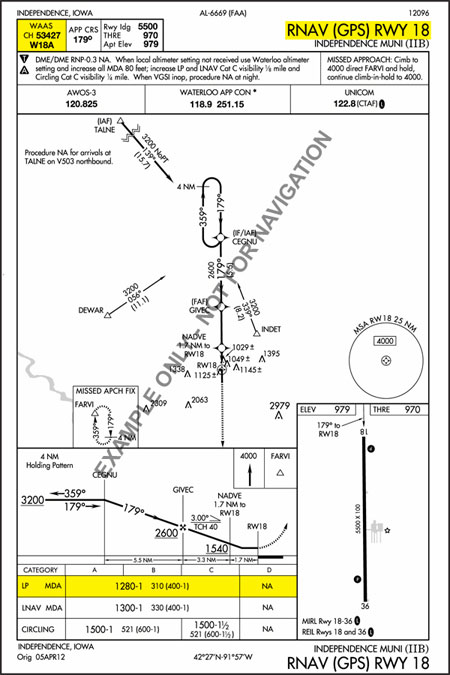
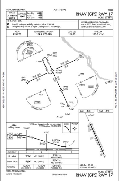
Lateral Navigation (LNAV) approaches are non-precision approaches that provide lateral guidance. The pilot must check RAIM (Receiver Autonomous Integrity Monitoring) prior to the approach when not using the Wide Area Augmentation System (WAAS) equipment.

Both LP and LNAV lines of minima are Minimum Descent Altitudes (MDA) rather than Decision Altitude (DA). It is possible to have LP and LNAV lines of minima published on the same approach chart. An LP is published if it provides lower minima than the LNAV. See AIM 1-1-20.

Please note: The chart below is just an example and not to be actually used. There are approaches where the LP is lower. 

Example: RNAV(GPS) Y RWY 17 at York, PA (THV)

York PA 05137R17


« Back to NAS Implementation - Procedures

Satellite Navigation - NAS Implementation

NAS Implementation - Procedures - GPS Overlay

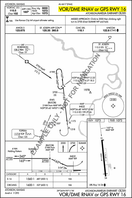
GPS Overlay Instrument Approach Procedures (IAPs) were the result of an FAA initiative in the 1990s to add "or GPS" to the name of an already existing VOR, VOR/DME, VOR/DMERNAV or NDB approach. The designation allowed the use of certified GPS receivers to fly the approach rather than relying on the VOR, VOR/DME or NDB signal.

"GPS overlay approaches are predicated upon the design criteria of the ground-based NAVAID used as the basis of the approach." (Aeronautical Information Manual (AIM) , section 1-1-19).

GPS Overlay IAPs are being phased out and replaced by newer types of approach procedures.

Example: VOR/DMERNAV or GPS Rwy 16 at Amelia Earhart, Atchinson, KS (K59)

VOR/DME RNAV or GPS Rwy 16 at Amelia Earhart, Atchinson, KS (K59)

« Back to NAS Implementation - Procedures

Satellite Navigation - NAS Implementation

NAS Implementation - Procedures - GPS Stand-Alone

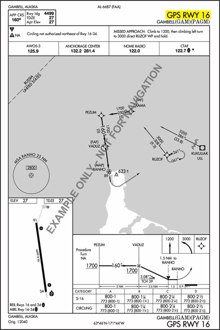
Stand-alone GPS approaches are also an older type of approach procedure. Today, there are less than 200 GPS stand-alone IAPs in the U.S. and this number continues to decline.

"Stand-alone GPS procedures are not based on any other procedures … The naming convention used for stand-alone GPS approaches is 'GPSRWYXX' … These procedures will eventually be converted to RNAV (GPS) approaches." (FAA Instrument Procedures Handbook, p. 5-11).

Example: GPSRWY 16 in Gambell, Alaska (GAM)

GPS RWY 16 in Gambell, Alaska (GAM)

For a current list of GPS Stand Alone IAPs, please visit our GPS/WAAS Approaches page

« Back to NAS Implementation - Procedures

Satellite Navigation - NAS Implementation

NAS Implementation - Procedures - Ground Based Augmentation System (GBAS) Landing System (GLS)

"GLS" is the acronym for Ground Based Augmentation System (GBAS) Landing System.

GLS was originally published as a placeholder for both Wide Area Augmentation System (WAAS) and GBAS minima and marked as N/A since no minima was published.

As the concepts for GBAS and WAAS procedure publication have evolved, it was decided that GLS will now only be associated with GBAS and will be on a separate approach chart. For more information on GLS approach procedures, please refer to the AIM section 1-1-21 and section 5-4-5.

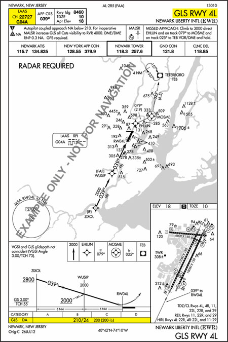
Example: GLSRWY 4L at Newark Liberty International (EWR)

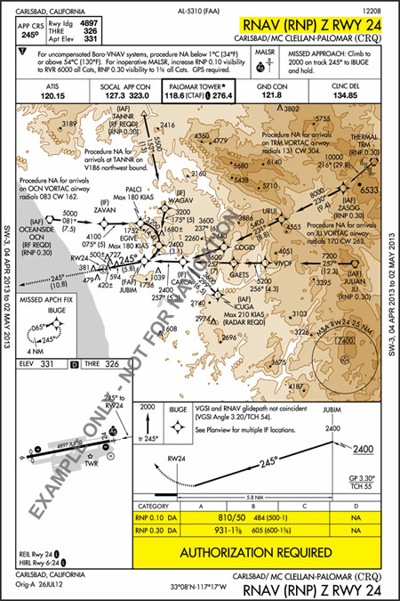
RNAV (RNP) Z RWY 24 at Carlsbad/McClellan-Palomar (CRQ)
The Ground Based Augmentation System (GBAS) program is managed by the FAA Aviation NextGen and Operations Planning Service Unit (ANG-C32) at the FAA William J. Hughes Technical Center. More information about GBAS can be found at http://laas.tc.faa.gov/.

Note: The U.S. version of the Ground Based Augmentation System (GBAS) was formerly referred to as the Local Area Augmentation System (LAAS). The worldwide community adopted GBAS as the official term for this type of navigation system. To coincide with international terminology, the FAA also adopted the term GBAS to be consistent with the international community.

« Back to NAS Implementation - Procedures

Satellite Navigation - GBAS - News

Wednesday, November 27, 2024

Ground Based Augmentation System (GBAS) - News


May 29, 2014 - Sydney Airport Commissions GBAS for Category I Service


The Ground Based Augmentation System (GBAS) at Sydney International Airport has been approved to provide precision approach and landing guidance to Category (CAT) I minima. Australia published Aeronautical Information Package (AIP) Supplement (SUP) H11/14 on May 29, 2014 that notes this approval.

More on Air Services Australia's plans for GBAS

May 5, 2014 - GBAS is Now Available for Use at Malaga-Costa del Sol Airport in Spain

Ground Based Augmentation System (GBAS) satellite navigation technology is now in operation at Malaga-Costa del Sol Airport in Spain. A ceremonial flight with Air Berlin was organized by navigation service provider Aeropuertos Españoles y Navegación Aérea (AENA) Air Navigation Directorate on May 5 to mark the start of the system's use for unrestricted commercial flight operations.

For more on this story, see the related article.

Joint press release from the Ministerio de Fomento and AENA.

November 21, 2013 - SESAR Tests ILS-for-GBAS Swap in Europe

In September, SESAR partnered with Honeywell, Airbus, Thales, DFS and Eurocontrol to carry out flight tests with a Dassault Falcon 900EX business jet using GBAS CAT II/III ground equipment (GASTD) at both Frankfurt and Toulouse. Full article

April 22, 2013 - Bush Intercontinental Airport Marks Arrival of Groundbreaking Technology to Increase Flight Capacity

Refer to the following caption.
@ Houston Airport System

Houston's George Bush Intercontinental Airport (IAH) became fully operational with the first precision approach flown by a United Airlines aircraft using Honeywell's SmartPath Ground Based Augmentation System (GBAS) on Monday, April 22. IAH is one of two airports in the country participating in a pilot program, in partnership with the Federal Aviation Administration (FAA), United Airlines and Honeywell to demonstrate the use of GBAS. Full article

November 8, 2012 - United Cleared for Newark GBAS

The Ground Based Augmentation System (GBAS) at Newark Liberty International Airport has been given the green light, clearing the way for United Airlines to start regular passenger flights using its specially equipped Boeing 737-800 and 737-900 fleet. Full article

September 28, 2012 - First U.S. Ground Based Augmentation System (GBAS) Operational at Newark Airport

A milestone in the development of the Ground Based Augmentation System (GBAS) was reached on September 28, 2012 with the operational approval of the GBAS installed at Newark Liberty International Airport. Full article(PDF)

February 13, 2012 - Satellite-Based Precision Landing System Now Operational

Refer to the following caption.
On 9th of February, the first fully operational GNSS Landing System (GLS) approach to CAT I decision height was made.

On 9th of February, the first fully operational GNSS Landing System (GLS) approach to CAT I decision height was made by an AirBerlin flight to Bremen airport in Germany; this marks the beginning of the operational use of satellite navigation (GNSS) for all phases of flight, including the most critical approach and automatic landing phases.

GLS is a precision approach operation using the ICAO-standard GBAS (Ground Based Augmentation System) components. It is the result of over 15 years of collaboration between multiple international partners. It is an alternative to the current precision approach standard, the instrument-based landing system (ILS). Full article

February 10, 2012 - Airberlin Starts Using Satellite-Based Precision Landing System for Regular Flight Operations

Following the German Federal Office for Air Traffic Control's accreditation of the ground station for the new satellite-based approach and landing system GBAS (Ground Based Augmentation System) as a primary landing system, airberlin will be the first airline in Europe to use satellite-based landings on regular flights at Bremen Airport. Full article

February 9, 2012 - Satellite-Based Landing System Certified - GBAS Debut at Bremen Airport

The satellite-based precision approach system GBAS (Ground Based Augmentation System) has received the German type certification as a primary landing system by the Federal Supervisory Authority for Air Navigation Services (BAF) and may be used independently of the instrument landing system (ILS) which has been is use for decades for instrument flights. Full article

Stay Informed

Subscribe to this page and be alerted when new News is posted. Click the Subscribe link under the menu bar above to sign up.

For more news, please be sure to check out the latest version of the SatNav News available online.

The Ground Based Augmentation System (GBAS) program is managed by the FAA Aviation NextGen and Operations Planning Service Unit (ANG-C32) at the FAA William J. Hughes Technical Center. More information can be found at http://laas.tc.faa.gov/

Operational Performance Evaluation

Wednesday, November 27, 2024

A laptop computer, pen, and clipboard with a bar graph and a pie chart that represent the types of information provided by the Performance Analysis program office.

The Performance Analysis Office is responsible for reporting on the overall operational performance of the NAS to the Air Traffic Organization's senior management and external organizations, and with anticipating near-term challenges. Core responsibilities include quarterly reports on ATO operational metrics to the COO and the Officer's group, projecting delays at major airports based on anticipated construction and airline schedule changes, and leading the FAA's metric harmonization process.

Core Operational Performance Products and Capabilities

Operational Metrics Chart

ATO Operational Metrics Review

Tracks the key operational metrics for the Air Traffic Organization that measure efficient use of airport capacity, efficient flight trajectories, delay by constraining facility, NAS equipment reliability, and the Average Daily Capacity (ADC).

Delay Projection Report

Airline Schedule Monitoring

Monitors airline schedules, and projects delays based on published airline schedules and historical capacities.

A delay projection report is distributed to operational facilities monthly and to cross agency groups quarterly to assist aviation stakeholders in planning for anticipated changes in performance.

Operational Metrics

FAA Operational Metrics

Reports key operational metrics identified by the FAA-wide metrics harmonization process, including those required by Congress under the FAA's authorization.

Air Traffic Projections

Air Traffic Projections

Projects near-term air traffic activity based on announced air carrier fleet plans and potential industry changes, such as airline mergers, in order to proactively address operational issues.

International Performance and Benchmarking

Wednesday, November 27, 2024

A flattend world with arrows connecting the countries.

The FAA works internationally to promote safety and to improve the operational efficiency of the global system. This is accomplished through work at ICAO, through CANSO and through bilateral agreements established between the US and other governments or Air Traffic Service providers.

ICAO logoThe office provides support to ICAO groups tasked with improving the performance reporting capabilities to member states. This effort is largely done through the ICAO Air Navigation Bureau and the Planning and Implementation Regional Groups (PIRGS). ICAO guidance on performance is contained in ICAO document 9883 as well as the most recent publications of Global Air Navigation Plan.

CANSO logoThe office provides support to the CANSO Operational Performance Work Group which is part of the CANSO Operations Standing Committee. The work items produced include technical documents and workshop materials whose purpose is to improve the ability of ANSPs to use operational metrics to improve management of air traffic services. The guidance documents and workshops provide worked examples designed to ease implementation and reduce the cost of building capabilities for members. (CANSO document of recommended operational metrics)

EC & EuroControl logoIn February of 2013, the United States and the European Union signed a special Annex under a Memorandum of Cooperation (MOC) to collaborate on Air Traffic Management performance measurement. This MOC continues existing work with EUROCONTROL that has been producing joint performance benchmarking since 2009.

In addition to producing these reports, FAA and the European Commission develop common position papers for ICAO on operational performance, and research performance measures that take advantage of data provided from ATC modernization technology.

Singapore Aviation logoIn September of 2013, the FAA and the Civil Aviation Authority of Singapore signed a MOC to collaborate on Air Traffic Management. The key elements of the MOC are to promote modernization and improve operational performance. Under the MOC, ATO Performance Analysis is working jointly with the Civil Aviation Authority of Singapore (CAAS) to develop and benchmark performance measures for surface operations and flight efficiency.

Obstruction Evaluation Group

Wednesday, November 27, 2024

Point of Contact in Alaska:
FAA / Obstacle Evaluation Group, Anchorage Office
Mailstop: AJV-15
222 West 7th Avenue, Box 14
Anchorage, AK 99513-7587

Email: Robert van Haastert
Phone: (907) 271-5863
Fax: (907) 271-2850

Obstruction Evaluation / Airport Airspace Analysis (OE/AAA) - Home Page

Determinations - View / Search Determinations

Sign-up for Email Announcements of Public Notices(PDF)

FAA Advisory Circular for Obstruction Marking and Lighting, AC 70/7460-1k(PDF, 3 MB)

FAA Advisory Circular for Obstruction Marking Specifications, AC 150/5345-53(PDF)

FAA Advisory Circular for Obstruction Lighting Certified Equipment & Manufacturers Lists(PDF)

Alaska Constructed Antenna Towers

Report Obstruction Light Outages CONUS and HI Anytime 24/7 at 1-877-487-6867

Report Obstruction Light Outages Alaska Anytime 24/7 at 1-800-478-3576


Questions?

Juneau Flight Service Station

Thursday, August 08, 2024

9230 Cessna Drive
Juneau, AK 99801-9377

Air Traffic Manager:
Rebecca Smith

Home Page

Flight Planning for IFRICAO Flights

  • Leaving Alaska for the Lower 48 involves crossing Canadian airspace. Filing an international (ICAO) flight plan is required for IFR flights. You will be asked by flight service to provide just a few extra pieces of information for an international flight plan.
  • Be prepared to give border crossing times. This means how many minutes after departure will you be crossing into Canadian airspace and how many minutes after departure will you be re-entering U.S. airspace. Your border crossing points must also be provided unless flying an airway. You may use lat/longs or intersections or navaids. These points should be within 50 miles of the border for entering and exiting Canadian airspace and also a point should be specified in US airspace close to the border.
  • IFR flight plans, to the Lower 48, with a departure point, a destination and simply a direct routing of are not acceptable. If departing off of Juneau you will also be asked by Juneau tower to file a departure procedure.
  • If you are planning a stop in Canada be sure to make your customs arrangements and advise flight service when filing that you have done this.
  • Finally, to expedite your flight plan file at least 30 minutes prior to your proposed departure. During the busy summer months this helps everyone from flight service, to tower, to Anchorage Center to fit you in and helps you to avoid a ground delay for flight planning.

Additional information:

ICAO Flight Plans - FAA Air Traffic Publications Reference.

International Flight Information Manual (IFIM) - FAAIFIM website.

Top of Page


Questions or Comments Welcome