USA Banner

Official US Government Icon

Official websites use .gov
A .gov website belongs to an official government organization in the United States.

Secure Site Icon

Secure .gov websites use HTTPS
A lock ( ) or https:// means you’ve safely connected to the .gov website. Share sensitive information only on official, secure websites.

United States Department of Transportation United States Department of Transportation

ato

Left Nav - Air Traffic Organization

Juneau Flight Service Station

Thursday, August 08, 2024

9230 Cessna Drive
Juneau, AK 99801-9377

Air Traffic Manager:
Rebecca Smith

Home Page

Dedicated to the Memory of David Scheytt

On July 6, 1984, local helicopter pilot David Scheytt and his co-pilot, Doug Brown, were notified of an aircraft crash in a pond near the Juneau Airport.  Reacting immediately, the two raced for a helicopter and proceeded to the scene of the accident. Upon their arrival, they found the passenger, Alaska Sate Trooper Nils Monsen, injured and in shock near the submerged wreckage of the aircraft, while the pilot, Trooper Cpl. Warren Grant, was still strapped in the cockpit. Mr. Brown leaped into the water, dove down to free Cpl. Grant, and brought him to the surface. In the meantime, Mr. Scheytt ferried Trooper Monsen to shore into the hands of rescuers, and then returned to the crash site.  The heroic actions of this crew undoubtedly saved at least one life on this date and forever earned the gratitude and respect of the Alaska State Troopers, and the families and friends of the victims.

Less than one year later, Mr. Scheytt tragically lost his life when the helicopter he was flying crashed near the Greens Creek Mine on Admiralty Island.

In honor of his heroic achievement and his selfless actions, the Alaska Peace Officers Association and the Federal Aviation Administration are proud to dedicate this building to the memory of …

Mr. David Scheytt

Top of Page


Questions or Comments Welcome

Satellite Navigation - GPS - Control Segment

Monday, November 25, 2024

GPS - Control Segment

The Control Segment of GPS consists of:

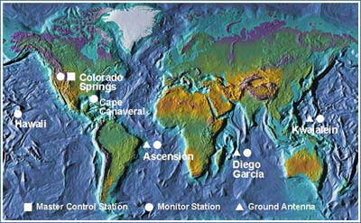
Master Control Station: The master control station, located at Schriever Air Force Base in Colorado Springs, Colorado, is responsible for overall management of the remote monitoring and transmission sites. GPS ephemeris being a tabulation of computed positions, velocities and derived right ascension and declination of GPS satellites at specific times, replace "position" with "ephemeris" because the Master Control Station computes not only position but also velocity, right ascension and declination parameters for eventual upload to GPS satellites.

Earth Map with Marked Control Stations, Monitor Stations and Ground Antennas

Monitor Stations: Six monitor stations are located at Schriever Air Force Base in Colorado, Cape Canaveral, Florida, Hawaii, Ascension Island in the Atlantic Ocean, Diego Garcia Atoll in the Indian Ocean, and Kwajalein Island in the South Pacific Ocean.Six additional monitoring stations were added in 2005 in Argentina, Bahrain, United Kingdom, Ecuador, Washington DC, and Australia. Each of the monitor stations checks the exact altitude, position, speed, and overall health of the orbiting satellites. The control segment uses measurements collected by the monitor stations to predict the behavior of each satellite's orbit and clock. The prediction data is up-linked, or transmitted, to the satellites for transmission back to the users. The control segment also ensures that the GPS satellite orbits and clocks remain within acceptable limits. A station can track up to 11 satellites at a time. This "check-up" is performed twice a day, by each station, as the satellites complete their journeys around the earth. Noted variations, such as those caused by the gravity of the moon, sun and the pressure of solar radiation, are passed along to the master control station.

Ground Antennas: Four ground antennas monitor and track the satellites from horizon to horizon. They also transmit correction information to individual satellites.

Satellite Navigation - GPS - Space Segment

Monday, November 25, 2024

GPS - Space Segment

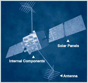
The space segment includes the satellites and the Delta rockets that launch the satellites from Cape Canaveral, in Florida. GPS satellites fly in circular orbits at an altitude of 10,900 nautical miles (20,200 km) and with a period of 12 hours. The orbits are tilted to the earth's equator by 55 degrees to ensure coverage of polar regions. Powered by solar cells, the satellites continuously orient themselves to point their solar panels toward the sun and their antenna toward the earth. Each of the 32 satellites, positioned in 6 orbital planes, circles the earth twice a day.

The satellites are composed of:

Solar Panels. Each satellite is equipped with solar array panels. These panels capture energy from the sun, which provides power for the satellite throughout its life.

External components such as antennas. The exterior of the GPS satellite has a variety of antennas. The signals generated by the radio transmitter are sent to GPS receivers via the L-band antennas. Another component is the radio transmitter, which generates the signal. Each of the 32 satellites transmits it's own unique code in the signal.

GPS Satellite

Internal components such as atomic clocks and radio transmitters. Each satellite contains four atomic clocks. These clocks are accurate to at least a billionth of a second or a nanosecond. An atomic clock inaccuracy of 1/100th of a second would translate into a measurement (or ranging) error of 1,860 miles to the GPS receiver.

Satellite Navigation - GPS - User Segment

GPS - User Segment

The user segment includes the equipment of the military personnel and civilians who receive GPS signals. Military GPS user equipment has been integrated into fighters, bombers, tankers, helicopters, ships, submarines, tanks, jeeps, and soldiers' equipment. In addition to basic navigation activities, military applications of GPS include target designation, close air support, "smart" weapons, and rendezvous.

With the surge in popularity of GPS receivers over the past several years, the civilian community has its own large and diverse user segment. Surveyors use GPS to save time over standard survey methods. GPS is used by aircraft and ships for enroute navigation and for airport or harbor approaches. GPS tracking systems are used to route and monitor delivery vans and emergency vehicles. In a method called precision farming, GPS is used to accurately guide farm machinery engaged in plowing, planting, fertilizing, and harvesting. GPS is available as an in-car navigation aid and is used by hikers and hunters. Most smartphones feature GPS map or navigation applications. Because the GPS user does not need to communicate with the satellite, GPS can serve an unlimited number of users.

The aviation community is using GPS extensively. Aviation navigators, equipped with GPS receivers, use satellites as precise reference points to trilaterate the aircraft's position anywhere on or near the earth. GPS is already providing benefits to aviation users, but relative to its potential, these benefits are just the beginning. The foreseen contributions of GPS to aviation promise to be revolutionary. With air travel nearly doubled in the 21st Century, GPS can provide a cornerstone of the future air traffic management (ATM) system that will maintain high levels of safety, while reducing delays and increasing airway capacity. To promote this future ATM system, the FAA's objective is to establish and maintain a satellite-based navigation capability for all phases of flight.

Sitka Flight Service Station

Thursday, August 29, 2024

365 Airport Road
Sitka, AK 99835
Air Traffic Manager:
Rebecca Smith

Home Page

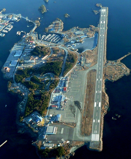
Sitka Airport Aerial Photograph

© Photo Copyright Protected - used by permission

Sitka FSS

Sitka FSS is a part-time facility open from 1500-0645Z and is located on the 3rd floor of the "Tower" building, (365 Airport Rd). The Tower building is located on the east end of the airfield and is accessible from both the Ramp and Airport Road. We provide face-to-face pilot briefings, or information may also be obtained by calling the local Briefing number, 907-966-2221/2222 or by contacting JNU FSS toll free 866-297-2236. We also provide inflight information on one of our numerous remote frequencies throughout southern Alaska.

Sitka FSS provides local airport advisories, LAA, for the Rocky Gutierrez Airport, on frequency 123.6. Pilots are encouraged to monitor the Sitka AFIS, (Automatic Flight Information Service), on 135.9 prior to contacting FSS. On initial contact, advise the FSS specialist of your aircraft ID and type, location, intentions and AFIS code. Remember that LAA is for advisories only. We request you use 122.2, 122.45 or the phone numbers listed above for questions or a weather briefing. For fuel after hours, contact Unicom frequency, 122.95 or call 907-747-7222.Anchorage Center frequency in the Sitka area is 126.1.

Sitka airport is under Class E airspace. (For SVFR seelink)

The Sitka FSS flight plan area is comprised of four hard surface airports, Sitka, Kake, Petersburg and Wrangell. There are 14 public use seaplane bases, in the Sitka flight plan area, not to mention the thousands of picturesque bays, coves and lakes that are frequented by float plane pilots.

Top of Page


Questions or Comments Welcome

Juneau Flight Service Station

Home Page

Juneau Visual Check Points, and Flight Advisory Frequencies

Refer to the following caption.
Juneau Inset
View Image(PDF, 375 KB)
Refer to the following caption.
Juneau Sectional
View Image(PDF, 675 KB)

Juneau Area Frequencies

Facility NameFrequency
Juneau RCO118.7
Robert Baron RCO121.1
Juneau Downtown RCO122.15
Juneau FSS122.2
Juneau CTAF (when ATCT Closed)118.7
Juneau ASOS/ATIS135.2
Juneau Tower118.7 120.7 278.3
Juneau Ground Control121.9
National Guard Operations124.65
Anchorage ARTCC133.9

Visual Check Points

LocationLatitudeLongitude
Annex Power58°19′03″ N134°06′01″ W
Arden Point58°09′30″ N134°10′37″ W
Barlow Cove58°21′38″ N134°53′26″ W
Battleship Island58°21′34″ N134°39′53″ W
Bullion Mine58°15′08.05″ N134°21′30.32″ W
Camp 1758°22′03″ N134°21′56″ W
Coghlan Island58°23′13″ N134°42′04″ W
Cooper Point58°14′09″ N134°06′12″ W
Douglas Bridge58°17′56″ N134°25′46″ W
Douglas Heliport58°19′56″ N134°29′50″ W
Dupont Dock58°13′40.67″ N134°15′59.24″ W
Eagle Beach38°31′40″ N134°49′35″ W
Eagle Pass58°24′20″ N134°48′51″ W
Eaglecrest58°16′27″ N134°30′46″ W
Flat Point58°20′10″ N134°03′23″ W
Funter Pass58°16′24.25″ N134°51′34.85″ W
George Rock58°18′54″ N134°42′04″ W
Glory Hole58°16′04.45″ N134°22′54.81″ W
Grizzly Bar58°23′28″ N134°03′43″ W
Hawk Inlet58°09′13″ N134°45′59″ W
Horse and Colt Islands58°15′45″ N134°43′56″ W
Jaw Point58°16′48″ N134°40′52″ W
Lemon Creek58°22′17.35″ N134°28′05.9″ W
Lower H&M Pass58°32′21.55″ N134°34′34.49″ W
Lucky Me58°13′28.05″ N134°17′40.07″ W
Marmion Island58°11′55″ N134°15′25″ W
Mayflower58°16′35″ N134°23′04.24″ W
Mendenhall Lake58°25′22″ N134°33′57″ W
Middle Point58°14′54.13″ N134°37′43.35″ W
North Branch58°32′45.76″ N134°28′07.4″ W
Nugget Valley58°25′28.81″ N134°29′56.39″ W
Outer Point58°18′07″ N134°41′18″ W
Pederson Hill58°22′25″ N134°38′00″ W
Point Bishop58°12′03″ N134°09′00″ W
Point Couverden58°11′26″ N135°03′20″ W
Point Hilda58°13′02.34″ N134°30′4.93″ W
Point Howard58°17′22″ N135°03′20″ W
Point Lena58°23′45″ N134°46′39″ W
Point Retreat58°24′41″ N134°57′18″ W
Portland Island58°21′07″ N134°45′31″ W
Rabbit Ears58°32′21.45″ N134°30′13.21″ W
Rifle Range58°24′54″ N134°36′23″ W
Rock Dump58°17′14.05″ N134°23′32.71″ W
Salisbury Point58°12′18.28″ N134°13′06.43″ W
Salmon Creek58°19′49″ N134°28′28″ W
Sheep Creek58°15′36.77″ N134°19′49.44″ W
South Shelter Island58°22′30″ N134°48′31″ W
South Tip58°20′30″ N134°37′51″ W
Spaulding Meadows58°25′13.67″ N134°42′30.71″ W
Spencer Pass58°29′05.27″ N134°26′01.64″ W
Spuhn Island58°20′05″ N134°39′37″ W
Suicied Ice Falls58°27′51″ N134°29′02″ W
Sunny Cove58°18′12″ N134°08′25″ W
Thunder Bowl58°23′40.25″ N134°31′05.90″ W
Upper H&M Pass58°34′22″ N134°32′02″ W
West Juneau58°17′27.73″ N134°26′56.09″ W
Windfall Lake58°30′22.25″ N134°43′32″ W

Top of Page


Questions or Comments Welcome

FCC Antenna Structure Registration Search Alaska Constructed Towers, 199+ AGL

Monday, November 25, 2024

Current as of June 4, 2007

Alaska Constructed Towers
Reg. #Owner NameLongitudeLatitudeCitymft
1007418Alaska Public TeleCommunications61-25-20.0N149-52-28.0WKnik246.4808
1065249Cobb Communications, INC. (KVOK)57-46-30.0N152-32-15.0WKodiak143.0469
1005658Evangelistic AK Missionary Fellowship64-45-32.0N147-19-35.0WNorth Pole130.0427
1007555Peninsula Communications, INC59-41-01.0N151-37-59.0WHomer123.7406
1005016Alaska Broadcasting Company, INC61-11-31.0N149-54-09.0WAnchorage119.5392
1058620Borealias Broadcasting, INC64-48-27.0N147-29-43.0WFairbanks114.3375
1005579ALASCOM, INC.63-03-42.0N141-49-40.0WTok Junction111.3365
1237097ACS Wireless60-31-51.9N150-52-01.5WSoldotna111.2365
1216479MCC Radio, LLC61-20-17.0N150-02-11.0WPort MacKenzie109.7360
1039482MCC Radio, LLC61-07-10.0N149-53-50.9WAnchorage109.1358
1037029Dillingham City Schools59-02-40.0N158-27-15.0WDillingham107.6353
1063079MCC Radio, LLC61-07-12.0N149-53-49.9WAnchorage106.4349
1206943Alaska Telephone Company63-19-13.5N142-47-46.5WTok106.4349
1002771Tanana Valley Television Company64-55-19.0N147-43-04.0WFairbanks105.5346
1005539ALASCOM, INC.59-52-52.0N151-47-10.0WAnchor Point102.1335
1005851Bay Broadcasting Company, INC58-44-37.0N156-58-40.0WNaknek102.1335
1005575ALASCOM, INC.60-31-56.0N151-05-00.0WSoldotna99.1325
1005017Tanana Valley State Fair Association64-51-47.0N147-45-15.0WFairbanks99.0325
1029038Alaska Broadcast Communications, Inc.58-19-46.0N134-28-23.0WJUNEAU99.0325
1210091Peninsula Communications, INC60-30-36.0N151-16-20.1WKenai97.7321
1007554Peninsula Communications, INC (KGTL)60-30-37.0N151-16-20.0WKenai97.5320
1005015TCT Communications, INC61-12-23.0N149-55-28.0WAnchorage96.0315
1005553ALASCOM, INC.62-24-45.0N145-06-30.0WGlennallen96.0315
1005554ALASCOM, INC.62-58-03.0N145-28-14.0WGlennallen96.0315
1018725MTA Communications, INC.61-33-56.7N149-43-00.1WBig Lake96.0315
1003111Alaska, State of60-00-33.0N151-42-53.0WNinilchik94.5310
1023331New Northwest Broadcasters LLC64-52-42.0N147-40-15.0WFairbanks93.6307
1003053Voice For Christ Ministries (KIAM)64-28-41.0N149-05-19.0WNenana93.2306
1244505United Utilities, INC.60-12-57.4N162-00-43.4WEek92.6304
1014788ALASCOM, INC.64-02-15.0N145-43-46.0WDelta Junction92.4303
1003117Alaska, State of60-32-13.0N150-54-22.0WSterling91.4300
1003410Northern Light Network62-06-50.0N145-32-15.0WGlennallen91.0299
1223185Voice for Christ Ministries61-38-02.1N149-47-42.4WHouston90.5297
1005576ALASCOM, INC.60-12-51.0N151-24-52.0WSoldotna88.4290
1010159ALASCOM, INC.63-38-56.0N144-03-53.0WTok Junction88.4290
1003115Alaska, State of63-23-03.0N143-47-51.0WCatheral Rapids85.4280
1063542Kachemak Bay Broadcasting, INC.59-40-12.0N151-26-46.0WHomer84.8278
1003114Alaska, State of64-18-20.0N146-32-54.0WCanyonCk Camp83.8275
1028325AK-Juneau Communications, (KINY)58-18-04.0N134-26-32.0WJuneau82.9272
1003107Alaska, State of60-32-46.0N150-37-04.0WNaptown82.3270
1003207Alaska, State of59-45-20.0N151-46-29.0WAnchor Point81.7268
1005548ALASCOM, INC.63-47-59.0N145-00-32.0WDelta Junction80.8265
1005551ALASCOM, INC.64-24-33.0N146-57-23.0WFairbanks80.8265
1005569ALASCOM, INC.60-31-46.0N150-35-00.0WNaptown80.8265
1014789ALASCOM,INC.62-06-35.0N145-32-57.0WGlennallen80.8265
1005543ALASCOM, INC.60-47-38.0N161-45-47.0WBethel80.5264
1001754Bethel Broadcasting, INC60-47-30.3N161-46-30.3WBethel78.8259
1251008United Utilities, INC.59-56-02.9N164-03-04.0WKipnuk77.4254
1005545ALASCOM, INC.64-17-48.0N149-05-31.0WClear77.1253
1224285Terminal Radio, INC61-06-40.0N146-15-39.0WValdez76.2250
1008604ALASCOM, INC.63-05-39.0N149-30-27.0WHonolulu75.6248
1244908Unicom, INC.59-43-43.3N161-54-26.7WQuinhagak74.4244
1004410Catholic Bishop Northern Alaska64-29-13.0N165-18-07.0WNome71.9236
1006187Capstar Radio Operating Company64-52-46.0N147-40-38.0WFairbanks71.6235
1245579United Utilities, INC59-58-12.3N162-51-20.1WKongiganak71.6235
1026698BP Exploration Alaska, INC70-09-03.0N147-05-51.0WDeadhorse70.1230
1003206Alaska, State of63-19-27.0N142-59-56.0WTOK69.5228
1005547ALASCOM, INC.63-47-14.0N145-51-47.0WDelta Junction69.5228
1005580ALASCOM, INC.63-23-05.0N143-47-46.0WTok Junction69.5228
1004220Copper Valley Telephone Cooperative61-42-46.0N145-08-03.0WTonsina68.9226
1002145King Broadcasters, INC (KSLD KKIS)60-31-24.0N151-03-31.0WSoldotna68.8226
1063728KMBQ CORP61-38-30.4N149-26-21.4WWasilla68.0223
1244797United Utilities, INC60-46-53.8N161-53-01.6WBethel67.4221
1005565ALASCOM, INC.58-23-28.0N134-46-06.0WLena Point67.1220
1006695GCI Communication Corp70-14-05.0N148-22-34.0WPrudhoe Bay67.1220
1014403Peak Oil Field Service CO70-13-49.0N148-22-36.0WDeadhorse67.0220
1042009Alaska Telecom, INC70-13-54.0N148-22-57.0WDeadhorse67.0220
1045669Conoco Phillips Communications, INC.70-20-22.0N149-34-52.0WKuparuk67.0220
1045675Conoco Phillips Communications, INC.70-19-30.0N149-36-30.0WKuparuk67.0220
1003112Alaska, State of61-36-06.0N149-21-49.0WWasilla66.8219
1034326Copper Valley Telephone Cooperative62-43-16.0N144-02-26.0WSlana66.0217
1034327Copper Valley Telephone Cooperative62-35-47.0N144-38-56.0WChistochina66.0217
1006696GCI Communication Corp64-55-49.0N147-29-58.0WFairbanks64.0210
1045667Arco Communications, INC.70-17-29.0N148-42-06.0WPrudhoe Bay64.0210
1059096ChevronUSA, INC.60-43-36.8N150-52-31.5WSterling62.5205
1008603ALASCOM, INC.63-50-14.0N148-58-49.0WHealy61.9203
1234368Arctic Slope Telephone Assoc. Coop.70-11-26.9N150-19-16.9WNuiqsut61.9203
1008607ALASCOM, INC.61-37-12.0N149-15-22.0WPalmer61.3201
1004474Big River Public Broadcasting (KIYU)64-41-16.0N156-43-38.0WGalena61.0200
1007417Alaska Pacific University61-11-23.0N149-48-24.0WAnchorage61.0200
1204036ACS Wireless, INC.61-20-08.8N149-30-56.2WEagle River61.0200
1244329ACS Wireless, INC.61-13-37.7N149-42-51.0WAnchorage61.0200
1003119Conoco Phillips Communications, INC.70-20-22.0N149-34-52.0WKuparak60.9200
1249192Matanuska Telephone Association61-43-20.9N150-10-41.0WWillow60.9200
1003205Alaska, State of61-10-33.0N149-47-04.0WAnchorage60.7199

Alaska's Tallest Towers

CityAGL
Port Clarence1358
Goose Bay808
Tok700 (4)
Attu Island700
Ketchikan625 (4)
Kodiak469
North Pole427
Homer406
Anchorage392
Fairbanks375
Tok365
Soldotna365
Port MacKenzie360
Anchorage358
Dillingham353
Anchorage349
Tok349
Fairbanks346
Naknek335
Anchor Point335
Soldotna325
Fairbanks325
Kenai321
Kenai320
Anchorage315
Big Lake315
Glennallen315 (2)
Ninilchik310
Fairbanks307
Delta Junction303
Sterling300
Glennallen299
Houston297
Soldotna290
Tok290
Cathedral Rapids280
Homer278
Canyon Creek Camp275


Questions?


Sitka Class E Surface Area and Special VFR

365 Airport Road
Sitka, AK 99835
Air Traffic Manager:
Maurice Gamble

Home Page

Sitka Airport Aerial Photograph

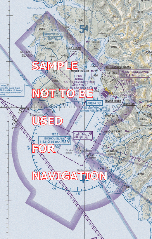
Sitka Class E airspace and Special VFR, (SVFR) information

For a complete explanation of Special VFR (SVFR) procedures, see 14 CFR 91.157 and the Aeronautical Information Manual (AIM) Chapter 4.

The dashed line that surrounds the area starting on the northern edge by Olga Strait continuing southeast through Sitka Airport and continues south-southwest around Biorka Island VOR is the Sitka Class E airspace.  Class E Sybology

Special VFR operations are performed in accordance with clearances within the Sitka Class E surface areas when weather conditions are less than the basic VFR minima.

There are some basic rules for Special VFR.

  • The pilot must request a Special VFR clearance. If a pilot requests to enter into or out of an area that is IFR, they will be advised that an ATC clearance is required; it is up to the pilot to initiate the request for Special VFR.
  • Fixed wing aircraft must have at least 1 mile ground visibility if there is an official weather report available. Where no official report is available, or if not landing or departing an airport within the Class E airspace, there must be at least 1 mile flight visibility.
  • Only one aircraft at a time may operate in the Sitka Class E surface area unless; a pilot requests and all pilots agree that they will maintain visual separation while operating in the Class E surface area.
  • IFR aircraft will have priority. If an IFR aircraft is inbound/outbound or transitioning through the Class E airspace, pilots requesting a Special VFR will be advised of a delay due to IFR traffic.

Top of Page


Questions or Comments Welcome