
NAS Implementation - Procedures - Lateral Navigation (LNAV) approaches
Lateral Navigation (LNAV) approaches are non-precision approaches that provide lateral guidance. The pilot must check RAIM (Receiver Autonomous Integrity Monitoring) prior to the approach when not using the Wide Area Augmentation System (WAAS) equipment.
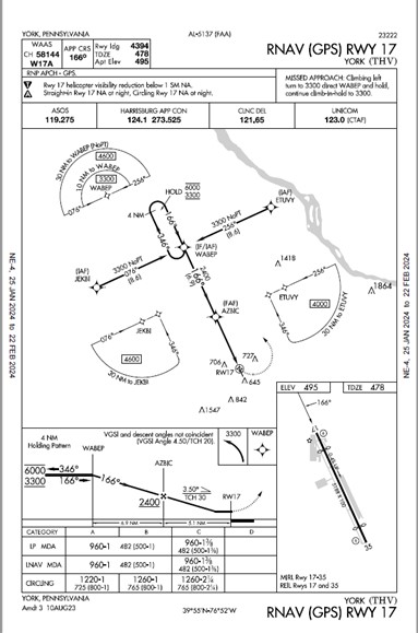
Both LP and LNAV lines of minima are Minimum Descent Altitudes (MDA) rather than Decision Altitude (DA). It is possible to have LP and LNAV lines of minima published on the same approach chart. An LP is published if it provides lower minima than the LNAV. See AIM 1-1-20.
Please note: The chart below is just an example and not to be actually used. There are approaches where the LP is lower.
Example: RNAV(GPS) Y RWY 17 at York, PA (THV)
Last updated: Thursday, April 11, 2024