
Aeronautical Charts Poster
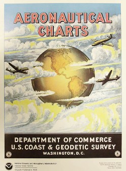 Originally published in 1959, promotes the availability of Aeronautical Charts during the early days of public air transportation. These posters were created to advertise aeronautical charts when they were published by the U.S. Coast and Geodetic Survey Office of the Department of Commerce. Aeronautical Charts were published under the The National Oceanic & Atmospheric Administration (NOAA) for many years until the Federal Aviation Administration took over the responsibility in 2000.
Poster measures 18" x 25". Quantities are limited.
Ellicott Map of Washington DC, 1800
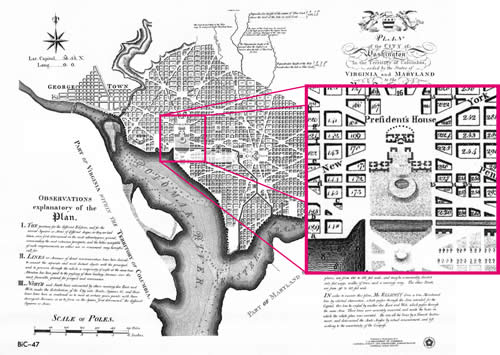
In the immediate aftermath of the Revolutionary War, one of the many problems faced by the new government was where to make its permanent seat, to be the capital of the new republic. Two cities, in particular, claimed the honor, New York and Philadelphia. However, neither city was sufficiently pre-eminent to claim the prize by right, and neither would give way to the other.
After much discussion, it was determined that a new city should be built, and an Act of Congress signed into law by Washington on 16th July 1790 enacted that a site on the Potomac River would become the new capital. Having chosen the site, Washington appointed an American engineer, Major Andrew Ellicott to survey and lay out the boundaries of the new Federal district. Ellicott received his instructions from Jefferson in a letter dated 2nd February 1791, and the course was completed by about September of the same year. It was intended that the plan should be published, but publication was not effected until 1794.
Poster measures 23" x 30".
L'Enfant Plan for Washington DC, 1792
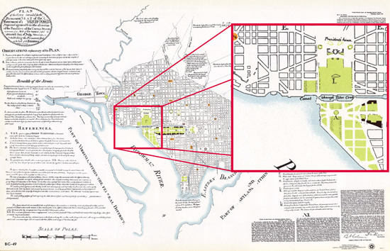
Washington appointed the French engineer Pierre Charles L'Enfant to survey the land designated for the city, and to produce a ground plan worthy of the new country, intended to be compared with any of the great European cities. To this end, Jefferson supplied L'Enfant with plans of several European cities so that he could extract the best features of each.
However, while the survey work continued, L'Enfant proved difficult, exasperating both Washington and Jefferson with his headstrong approach to solving problems, and dealing with interests of individuals affected by his grand scheme. One problem was that part of the construction costs were to be met by selling parcels of land within the city boundaries, yet sales started before the ground plan had been completed, and the boundaries of these parcels of land properly established on the ground.
In the end, Washington lost patience with L'Enfant, who was dismissed in 1792. L'Enfant was replaced by Major Andrew Ellicott. However, L'Enfant refused to hand over any of his survey work, so Ellicott was forced to reconstruct the plan from his own working notes and recollections. Ellicott's manuscript plan of the city is in the Library of Congress, although it is credited in the title to L'Enfant. It is thus difficult to know what parts of the finished plan is due to L'Enfant and how much credit is due to Ellicott.
Poster measures 30" x 46".
| Product | Product ID | Price |
|---|---|---|
| Aeronautical Charts Poster | APOST | $4.00 |
| Ellicott Map of Washington DC, 1800 | BIC47 | $6.00 |
| L'Enfant Plan for Washington DC, 1792 | BIC49 | $6.00 |