
Satellite navigation is being widely used by aviators throughout the world to overcome many of the deficiencies in today's air traffic infrastructure. With its accurate, continuous, all-weather, three (GPS only) and four (GPS with augmentations) dimensional coverage, satellite navigation offers an initial navigation service that satisfies many of the requirements of users worldwide. Unlike current ground-based equipment, satellite navigation permits accurate aircraft position determination anywhere on or near the surface of the earth.
More specifically, an aggressive exploitation of satellite navigation technologies provides substantial benefits to both the providers of such services in the region, as well as the individual and combined user communities. The implementation of this technology in a country or region provides the following benefits to aviation transportation:
- Enhanced safety of flight throughout the region
- Seamless navigation service based on a standardized navigation service and common avionics
- More efficient, optimized, flexible, and user-preferred route structures
- Increased system capacity
- Reduced separation minimums resulting in increased capacity and capabilities
- Significant savings from shortened flight times and reduced fuel consumption
- Reduced costs to each individual State while increasing overall benefits to individual States and the entire region
- Further economies from reduced maintenance and operation of unnecessary ground-based systems
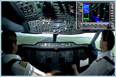
- Improved ground and cockpit situational awareness
- Increased landing capacity for aircraft and helicopters
Additionally, the implementation of this technology adds a margin of safety to operations within the expected coverage area by providing four-dimensional positioning, as opposed to the two-dimensional positioning of traditional systems. This reduces accidents by providing a consistent navigation capability that does not change, regardless of location, replacing major portions of current ground-based navigation infrastructures, and simplifying avionics suites. It also offers a precision approach capability at any airport within that region. All aircraft equipped with certified GPS/WAAS receivers have the needed accuracy, integrity, and availability for them to use GPS as a primary navigation aid, and thus experience the benefits of seamless travel.
Aircraft arriving at the terminal area use set instructions to lead them into the local area to begin their landing approach. The current Standard Terminal Arrival Routes (STARS) are based upon the placement of navigation aids, aircraft performance, and obstructions to flight. Through more accurate and continuous position information, GPS will offer more flexible routes, easing congestion, saving time and fuel, especially at high-density airports.
Aircraft departing from the terminal area must comply with set instructions that will lead them safely to their enroute departure point. The current standard instrument departures (SIDs) are based on factors such as navigational aids available, aircraft performance, and obstructions to flight. Because of its accurate and continuous location information, GPS will offer direct and flexible departure routed, ease congestion, and save time and fuel while maintaining high levels of safety.
Control and navigation of aircraft over land must rely on the use of ground hardware. Aircraft must normally fly from point to point to navigate to their destination. Flight paths are rarely direct.
With the advent of GPS, exact positional information is available to pilots. This enables direct routes, reduced flight times and reduced fuel consumption.
Landings based on GPS will eliminate many of the time and fuel-consuming maneuvers currently in use. Additionally, GPS can enable the addition of vertical guidance to landing scenarios where this capability did not formally exist. Vertical guidance is a key component to increasing safety.
Oceanic flights are out of range of ground-based surveillance systems. Controllers rely on position reports radioed periodically from pilots. Due to the time delays in receiving these reports, a significant distance must be kept between aircraft to ensure safety. GPS-equipped aircraft relay their position via digital data links through satellites to controllers. Knowing each aircraft's real-time position enables controllers to safely reduce aircraft separation, which increases capacity, reduces fuel consumption, and optimizes flight routes.
Surface traffic at airports is frequently busy. Controlling and monitoring that traffic becomes increasingly difficult as visibility decreases. The FAA is examining ways to use GPS with other technologies to help identify and locate surface vehicles during all kinds of weather conditions. That information could be used to help aviators and controllers safely navigate in the surface environment.
Last updated: