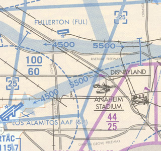
 VFR Flyway Planning Charts are printed on the reverse sides of the Atlanta, Baltimore-Washington, Charlotte, Chicago, Cincinnati, Dallas-Ft. Worth, Denver/Colorado Springs, Detroit, Houston, Las Vegas, Los Angeles, Miami, Orlando, New Orleans, Phoenix, St. Louis, Salt Lake City, San Diego, San Francisco and Seattle Terminal Area Charts (TACs). The scale of these charts is 1:250,000, with area of coverage the same as the associated TACs. Flyway Planning Charts depict flight paths and altitudes recommended for use to by-pass areas heavily traversed by large turbine-powered aircraft. Ground references on these charts provide a guide for visual orientation. VFR Flyway Planning charts are designed for use in conjunction with TACs and are not to be used for navigation.
| Chart Type | Nautical miles/inch | Nautical miles/cm | Scale |
|---|---|---|---|
| VFR Flyway Planning Charts | 3.43 | 1.35 | 1:250,000 |
* As mentioned above, VFR Flyway Planning Charts are printed on the back of specified Terminal Area Charts (TACs). When ordering Flyways use the corresponding TAC Product ID.
