Satellite Navigation - WAAS - News
March 5, 2014 - CNAV Announcement
The Department of Transportation has issued a Federal Register Notice (FRN) - "Global Positioning System Pre-Operational Civil Navigation; Message Continuous Broadcast". The purpose of this notice is to seek comment from the public and industry regarding plans by the United States Air Force to broadcast pre-operational L2C and L5 civil navigation (CNAV) messages from certain Global Positioning System (GPS) satellites beginning in April 2014.
For more information, please see the associated Federal Register Notice(PDF).
WAAS featured at Smithsonian National Air and Space Museum
September 25, 2013 - The Time and Navigation exhibit at the National Air and Space Museum on the National Mall in Washington, D.C. featured experts on the Wide Area Augmentation System (WAAS) to answer questions about the benefits of WAAS and explain the workings of satellite navigation.
- A link for the museum's posting about the WAAS event: https://timeandnavigation.si.edu/research/waas-meet-the-expert-educational-even
- An article about the event can be found in the Fall 2013 edition of the SATNAV News.

WAAS marks 10th anniversary
July 10, 2013 - Today marks the 10th anniversary of the Wide Area Augmentation System (WAAS) which was commissioned for use in the U.S. National Airspace System on July 10, 2003. Since that day WAAS has proven to be an accurate and reliable means of navigation that is available to all segments of the aviation community.
A Special WAAS 10th Anniversary Issue of SATNAV News has been posted on our website.
To find out if there is a WAAS-enabled approach procedure at an airport near you, please visit our GPS/WAAS Approaches page.
To learn how WAAS works, please visit our Wide Area Augmentation System - How It Works page.
New Video Posted for WAAS 10th Anniversary!
July 10, 2013 - Watch our new video, The WAAS Experience, to learn about the features and benefits of the Wide Area Augmenation System (WAAS).
View the video from an iPhone or iPad
CNAV Testing
June 2013 - Starting mid-June 2013, the Global Positioning System (GPS) Directorate (SMC/GP) will implement a CNAV (Civil Navigation) Test Program to conduct Live-Sky CNAV testing prior to deployment of the Next Generation Operational Control System (OCX). CNAV is a capability to be provided by Civil Navigation message types for the purpose of improved GPS navigation through the use of signals L2C and L5. Fifteen CNAV message types are defined in the current Interface Specification (IS-GPS-200F and ICD-GPS-705). CNAV message types will be tested in an incremental fashion in accordance with SMC/GP's program baseline plans. The full operational L2C CNAV capability will be included in the initial OCX delivery which is scheduled for deployment in mid-2016. The purpose of the testing is to ensure enterprise-level readiness to operate, broadcast and receive the modernized civil navigation messages on L2C and L5.
More information about CNAV and the upcoming testing can be found on the United States Coast Guard Navigation Center website. View the test plan.(PDF)
The Global Positioning Systems Directorate is a joint service effort directed by the US Air Force and managed at the Space and Missile Systems Center, Air Force Space Command, Los Angeles Air Force Base, California. The directorate is the Department of Defense acquisition office for developing and producing GPS satellites, ground systems and military user equipment.
Canadian LPVs
February 24, 2012 - NAV CANADA, Canada's civil air navigation services provider, currently provides Localizer Performance with Vertical Guidance (LPV) service at 36 airports with a total of 57 approaches published. Over the next 12-18 months NAV CANADA has 180 approaches pending design and publication at 92 airports.
"More LPVs will be published going forward based on a positive business case and a level of service assessment," said Gary Chandler, Manager, NAV CANADA Air Navigation Services (ANS) Program Co-ordination.
NAV CANADA is a private sector corporation. With operations coast to coast to coast, NAV CANADA provides air traffic control, flight information, weather briefings, aeronautical information services, airport advisory services, and electronic aids to navigation.
In recent months, the number of published LPVs in Canada has been incorrectly reported by the FAA in some forums. This incorrect number was a result of interpreting promising LPV candidate runways as current LPV runways. The FAAGNSS Program Office regrets the error.
FAA Approves First SBASRNP (AR)
November 2011 - In November 2011, the Federal Aviation Administration (FAA) approved Operations Specifications for Required Navigation Performance (RNP) 0.3 for regional air carrier Horizon Air. This is the first RNP Authorization Required (AR) using a Satellite Based Augmentation System (SBAS) platform, namely the Wide Area Augmentation System (WAAS). On November 22nd, Steve Bush, Horizon's flight operations manager, piloted the first approved RNP (AR) approach in 121 revenue service, flight 2064 from Seattle-Tacoma International Airport (SEA) to Pangborn Memorial Airport in Wenatchee, WA (EAT), using a WAAS platform.
Horizon Air, a Part 121 carrier, operates Bombardier Q400 turboprop aircraft, several of which have been equipped with Universal WAAS avionics under an FAA Government Industry Project managed by the WAAS Program Office. The project is designed to provide for flight and data collection activities to evaluate the benefits of WAAS utilization.

"Due to the mountainous terrain near the airport at Wenatchee," said Mr. Bush, "the use of a straight-in approach to Runway 30 was not feasible. However, through the application of Radius-to-Fix (RF) legs to bend the final course around obstacles, we have very good minimums through use of the RNP (AR) approach."
This event demonstrates that WAAS and RNP (AR) combination is a solid performer that belongs in the Performance Based Navigation (PBN) and NextGen "toolbox". Mr. Bush stated, "RNP and the WAAS platform provided by the Universal UNS-1Ew Flight Management System provides us with the best of both worlds. It is not necessarily an either/or choice between WAAS or RNP, rather, the two systems are complementary."
Exploiting the synergy between RNAVRNP (AR) and WAAS-enabled RNAVGPS approaches has been high on the FAA's list of PBN and NextGen objectives. That synergy lies in the combined use of Terminal Procedures (TERPS) criteria in design guidance orders 8260.52A (RNPAR) and 8260.54A (RNAV), where a combination or hybrid of the two orders will produce distinct performance, safety, and operational improvements for air navigation service providers, airspace designers, and aircraft owners and operators of all classes and categories of aircraft. This hybrid of RNP (AR)'s narrower protected air space and RF turn criteria, and the WAAS system's even narrower obstacle clearance areas near the approach end of the runway allow for consistent Category 1 instrument approach minima, that is, a ceiling of 200 feet and a half-mile visibility. This hybrid has the potential to provide greater operational and economic benefits to all but the most terrain- and obstacle-challenged airports.
WAAS is an extremely accurate method of Area Navigation (RNAV) developed for civil aviation that provides augmented GPS navigation service for all classes and categories of aircraft in all phases of flight, including enroute navigation routes such as National Route Plan routes (NRPs) and National Random Routes (NRRs), Q routes, and terminal instrument flight procedures such as departures, arrivals, and approaches.
RNP, a refinement of RNAV, is part of a collaborative effort by the FAA and the aviation industry to enable development of Performance Based Navigation (PBN) routes and flight procedures that are not dependent on any specific piece of avionics equipment. Aircraft flying these routes and procedures must demonstrate a required level of performance and be able to meet the operational requirements for the airspace, route, or procedure being flown. RNP enables more flexibility for procedure designers through the use of narrower obstacle clearance areas and RF legs or curved flight paths that exclude more terrain and obstacles along the flight path.
"Iono Robustness" Upgrade to Increase WAAS Reliability
October 2011 - During the fall of 2011, the Wide Area Augmentation System (WAAS) began a series of upgrades to increase its reliability. One of these upgrades, known as 'Iono Robustness', will increase the availability of the WAASLPV service during the upcoming solar maximum. The solar maximum refers to the peak of the 11 year solar cycle which is expected to occur in 2013. During solar maximum, the number of sun spots increases, greatly increasing the likelihood of solar flares. These flares tend to disturb satellite signals passing through the earth's atmosphere, specifically the ionosphere. Such events are referred to as a solar storm (also known as an "iono storm").
To ensure safety for users, the WAAS provides information about the ionosphere. The information is provided via a parameter called the Grid Ionospheric Vertical Error (GIVE). The GIVE parameter makes sure WAAS receivers properly account for the ionosphere when calculating a position. If the ionosphere is "quiet" (i.e. no iono storm) then the value of the GIVE parameter is small. But during an iono storm the GIVE value becomes larger. The GIVE parameter is one of the parameters used by a WAAS certified avionics receiver to support the LPV service. Larger GIVE values means that the LPV service from WAAS will be less available for use. The "Iono Robustness" upgrade of WAAS optimizes the GIVE algorithm with the goal of increasing LPV service from WAAS during an iono storm, while not compromising safety.
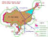
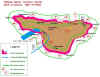
The two figures show how WAAS reacted to a recent iono storm.


Figure 1 shows the availability of WAAS on the current system during an iono storm on June 5, 2011. Figure 2 shows the availability WAAS would have experienced on that date using the improved GIVE algorithm software. The dark red color shows where WAASLPV service was available 100% of the time on the indicated day. In Figure 1, WAASLPV service was less than 100% in most of Canada and the north central portion of the United States. The improved GIVE algorithm software would have allowed WAAS to provide 100% LPV service for all of the contiguous United States and most of Canada during this solar event. Over the past few months there have been several iono storms and the performance WAAS would have experienced with the improved WAASGIVE algorithm software has been similar to the example of June 5, as shown in the figures.
It should also be noted that during an iono storm, WAAS does not shutdown. Instead, the value of the GIVE parameter is increased to ensure safety for users of the LPV service. As an iono storm subsides, the GIVE parameter value lessens and LPV service is restored.
WAAS Service for Alaska Fully Restored
March 18, 2011 - FAA officials have placed the Intelsat Galaxy 15 GEO satellite (also known as CRW) back into operational mode, thereby restoring Wide Area Augmentation System (WAAS) service to a large area in northwest Alaska. Dual GEO coverage over a large portion of the rest of Alaska has also been restored.
The decision to reinstate Galaxy 15 satellite's WAAS service came after successful testing of the WAAS signal-in-space (SIS). Galaxy 15 is currently at 120° West, moving west at 0.8° longitude per day. It is expected to arrive at its final assigned geostationary orbit at 133.1° West on April 4, 2011.
The restoration of dual GEO coverage significantly improves the availability of WAAS service across most of Alaska. The restoration of service affects 16 airports in northwest Alaska, two of which, Barrow (BRW) and Kotzebue (OTZ), have published Localizer Performance with Vertical Guidance (LPV) approach procedures.
In April 2010, the FAA was notified that communication with the portion of the Galaxy 15 GEO satellite that manages its movement had been lost. As a result, the satellite had started drifting from its assigned position. Engineers anticipated that at some point in late 2010 the Galaxy 15 GEO could no longer be used to broadcast the WAAS signal because its "earth-pointing" capability would be lost and the SIS would become unreliable or unavailable. This event did occur in mid-December and the Galaxy 15 GEO ceased broadcasting the WAAS signal. However, later in December 2010, the FAA was informed by Intelsat that a self-initiated restart had restored the satellite's command and control elements to normal. Intelsat had therefore regained the ability to communicate with and control the satellite.

LP Approaches Introduced
March 4, 2011 - The first Localizer Performance (LP) procedure was published at Tampa, Florida's Peter O. Knight airport (TPF), Runway 36, on January 13, 2011. This new approach takes advantage of the angular lateral guidance and smaller position errors allowed by WAAS to provide a lateral only procedure similar to an Instrument Landing System (ILS) Localizer. LP procedures may provide lower minima than a LNAV procedure due to the narrower Obstacle Clearance Surface (OCS).

The smaller LPOCS footprints provide greater potential for avoiding obstructions in the approach corridor that would otherwise drive the minima to be higher. The approach published at Tampa provides 60 feet lower Minimum Decision Altitude (MDA) compared to an LNAV approach on same runway.
LPs will be published at locations where the terrain or obstructions do not allow publication of Localizer Performance with Vertical Guidance (LPV) procedures. Several additional LP approaches are pending publication in the next few months, including Moline, IL - Quad City International Airport (MLI); Daytona Beach, FL - Daytona Beach International Airport (DAB); Ardmore, OK - Ardmore Downtown Executive Airport (1F0); Milwaukee, WI - Lawrence J Timmerman Airport (MWC); and many others.
“The introduction of LP procedures provides the lowest possible minimum descent altitude for aviators to access airports,” said Ted Urda of the FAA's Global Navigation Satellite System (GNSS) Group. “LPs provide another tool for our procedure developers to continue to achieve the FAA Flight Plan goal of publishing 500 GNSS procedures annually for the foreseeable future.”
Note -WAAS receivers certified prior to TSO C-145b and TSO C-146b, even if they have LPV capability, do not contain LP capability unless the receiver has been upgraded. Receivers capable of flying LP procedures must contain a statement in the Flight Manual Supplement or Approved Supplemental Flight Manual stating that the receiver has LP capability, as well as the capability for the other WAAS and GPS approach procedure types.
Intelsat CRWGEO Resets, Now Accepts Commands
January 6, 2011 - Ground control over Intelsat's Galaxy 15 geostationary (GEO) satellite, hosting a Wide Area Augmentation System (WAAS) Navigation Transponder, has been re-established. Intelsat and the satellite builder, Orbital Sciences Corporation, believe they have isolated the cause of the failure and have implemented corrective actions that will serve to prevent recurrence in the satellite (also known as Intelsat CRW). Intelsat is highly confident that the cause of failure has been fixed.
Intelsat is currently conducting initial diagnostic tests and will continue to assess the health of the satellite once it is moved to a temporary location at 93 degrees west longitude. After completion of testing, Intelsat plans to move the Galaxy 15 to its original orbital location of 133 degrees west or to another position close by. The Galaxy 15 should arrive at this final location in early March 2011.
The FAA is working with Lockheed Martin, the Ground Communications and Control Segment (GCCS) contractor, to test the navigation payload. With favorable testing results, the FAA expects to begin transmitting the WAAS Signal in Space from Galaxy 15 prior to reaching the final orbital position.
WAAS Intelsat GEO Satellite Ceases Broadcast
December 16, 2010 - The Wide Area Augmentation System (WAAS) Intelsat CRW geostationary (GEO) satellite has ceased broadcasting the WAAS signal as of today. The deterioration of the satellite's ability to remain stable over the past few days caused intermittent data link disruptions that rendered the satellite unreliable for further data transmissions. The FAA's mitigation plan to activate another satellite in November 2010 was successful and the new GEO satellite, Inmarsat AMR, has been transmitting the WAAS signal in addition to the Telesat CREGEO.

Operators in northwest Alaska, north of a line from 70N150W and 64N164W, can expect WAAS services to be unreliable. Two of the 16 airports located in the designated area, Barrow and Kotzebue, have published Localizer Performance with Vertical guidance (LPV) approaches. Any operators in this area should check Notice to Airmen Publication (NTAP), Alaska/Hawaii section 4-A & H-11, for operational limitations.
The WAAS broadcast over a large portion of the rest of Alaska will now be provided by a single GEO. WAAS users in this area may experience temporary service outages due to lack of redundant GEO signals. These outages will occur during a switch between the primary and backup GEO Uplink System (GUS) stations. These switchovers will occur approximately 4 - 5 times a month and it may take up to 5 minutes to fully restore LPV service after an occurrence.
WAASLPV Approaches Approved for Des Moines Helicopter Medical Flights
December 22, 2010 - In a significant advance for helicopter emergency medical service (HEMS) flight operations, the FAA has approved Instrument Flight Rules (IFR) arrivals and departures for use in the ongoing project by the "Mercy One" Bell 429 helicopter serving Mercy Medical Center in Des Moines, Iowa. The Mercy Medical Center program, among the nation's first HEMS operations to gain approval for Wide Area Augmentation System (WAAS) IFR navigation, was selected to be the test site for an FAA government-industry partnership (GIP) project designed to collect performance data on WAAS procedures. This data will help develop public use criteria of WAAS procedures and set the stage for broader future use of these procedures under the FAA's Next Generation Air Transportation System (NextGen) program.
IFR flights rely mainly on instrument navigation rather than visual observations and therefore allow missions to be flown in poor visibility conditions. "We miss about 240 flights a year due to the fact that the weather minimums are such that we can't fly," said Dan Keough, director of emergency transport services at Mercy. "We feel that with this new technology being state-of-the-art and the first of its kind in Iowa, we will recapture at least 20 percent of those weather misses that we currently have now."
The approved approaches use WAAS Localizer Performance with Vertical guidance (LPV) procedures, which provide comparable performance to Instrument Landing System (ILS) approaches, but without expensive ground based equipment at each landing site; it's all satellite based. The Mercy Medical Center LPV approaches are approved for glide paths up to 9-degrees at a minimum airspeed velocity for instrument procedures of 45 knots. According to Bell Helicopter, this will allow Mercy One to employ LPV procedures for steep approaches to a network of other hospitals and rendezvous helipads in adverse weather conditions, improving safety in low-altitude flight.
"WAAS technologies, when combined with the Bell 429, provide all helicopter operators engaged in IFR operations a vehicle to complete missions that were unthinkable in the past," said Larry D. Roberts, senior vice president of commercial business at Bell Helicopter. "This total aircraft solution will increase the number of missions that are flown and ultimately save more lives."
Six pilots in Mercy Medical Center's emergency response team have been trained to fly the Mercy One. Additional pilots will be trained on the aircraft in future months.
The GIP organizations involved in the Mercy One collaborative effort are Bell Helicopter, Air Methods (the company that operates Mercy Medical Center's emergency flights), the FAA, and Mercy Medical Center in Des Moines, Iowa.
The GIP team is developing a network of five fixed WAAS approaches in Iowa including the helipad at Mercy's main hospital in Des Moines plus approaches to three other regional hospitals in Centreville, Albia, and Osceola; as well as a brand new rural rendezvous IFR helipad in Stuart.
Air Methods and the Des Moines air traffic control (ATC) have signed a letter of agreement which enables Des Moines tower control to provide specific ATC guidance for Mercy One flights. These initial routes are the first part of a future low-level route structure for the entire Des Moines metro area, according to an FAA official.

"New Technology Allows Medical Pilots To 'Fly Blind'" broadcast on KCCI Des Moines, Iowa
October 26, 2010 - Using the Wide Area Augmentation System (WAAS), the emergency medical helicopters of Mercy Medical Center in Des Moines, Iowa can now fly in blinding snow or rain, as well as reach more rural areas. For more on this story, please visit our GNSSNAS Implementation News page.
Horizon using new guidance system for bad weather landings
February 23, 2010 - Life for pilots would be wonderful if every day were sunny and clear, free of haze and darkness. In the Northwest, that tends to be more of an exception. In this part of the country, rain, fog and low-hanging clouds can stick with us for months. Add in long nights and you begin to get an idea.
When you step into the cockpit of a Horizon Airlines Q-400 turboprop, you quickly get an idea of the tools that are brought to bear to fight back. The rest of the article by Glenn Farley at King 5 News.
CareFlite moves to the next milestone in the implementation of WAAS-enabled PinS and approaches
February 2010 - CareFlite has recently established a series of low altitude point-in-space (PinS) procedures enabled by the Wide Area Augmentation System (WAAS) throughout the Dallas-Fort Worth metropolitan area. A complementary low-level instrument flight rule (IFR) infrastructure has also recently been completed that links these PinS to WAAS localizer performance with vertical guidance (LPV) approaches for trauma center helipads. There are five WAASLPVs in development, one of which has already been commissioned. To support this initiative, the supplemental type certificate (STC) for the Agusta 109 has recently been completed. CareFlite will be using this aircraft to begin collecting data for both the enroute and approach approaches.
The benefits of the approved infrastructure and accompanying approaches will result in better emergency medical care service for the citizens of the Dallas-Ft. Worth area, in addition to environmentally-friendly procedures. With this added IFR capability, CareFlite will be able to provide more direct and more reliable access to trauma centers in poor weather conditions. Poor weather conditions can result in the rerouting of the aircraft to the nearest airfield as opposed to flying direct to the trauma center or termination of the transport. More direct access translates into more rapid medical care for the patient with a net result of more lives saved.
In addition to providing more reliable trauma center access, these IFR capabilities will also provide significant operational safety enhancements, as well economic advantages.
WAAS Intelsat GEO October 2010 Status
October 25, 2010 - The geostationary (GEO) satellite Intelsat (CRW) will continue broadcasting the WAAS signal at least into December 2010. The satellite had begun drifting earlier in the year (see article below) and Lockheed Martin informed the FAA the signal would be lost several months ago. Additional analysis has shown the satellite's useful life will continue until December. The FAA's mitigation plan to activate another satellite in November 2010 is still underway.
WAAS Intelsat GEO Currently Experiencing Technical Difficulties
August 5, 2010 (Update) - Intelsat has notified the Federal Aviation Administration of a technical issue currently being experienced with the telemetry tracking and control system (TT&C) of their Galaxy 15 satellite. The Intelsat Galaxy 15 is one of the geostationary satellites (GEO) that broadcasts the WAAS signal in space.
For WAAS users, there is no immediate impact to service; but over the next few weeks, the Intelsat GEO will drift out of its current orbit position, ultimately requiring the GEO broadcast to be discontinued. Sixteen airports north of a line from 70N150W and 64N164W in northwest Alaska are affected by the failure. Two of the airports located in the affected area have published LPV approaches. Please refer to Anchorage Center NOTAMS for specific guidance. Users in this area are required to confirm that GPS receiver autonomous integrity monitoring (RAIM) will be available for the flight during planning.
Operators using TSO-C145/C146 receivers for en route or terminal or approach IFR operations in the area of northwest Alaska designated in the paragraph above, are required to confirm GPSRAIM availability IAW Aeronautical Information Manual (AIM) paragraph 5-1-15 f. Due to reduced WAAS availability, any required alternate airport in this area must have an approved instrument approach procedure other than GPS that is anticipated to be operational and available at the estimated time of arrival and which the aircraft is equipped to fly IAWAIM paragraphs 1-1-20 c 6 and the note in 1-1-19 g. This information is being provided as a courtesy for our WAAS users. Please refer to Anchorage Center NOTAMS for specific guidance. For any WAAS airspace other than that of the northwest portion of Alaska referenced here, there are no other WAAS restrictions related to this issue.
After the Intelsat GEO service is discontinued, WAAS users outside the affected area of northwest Alaska, may experience temporary service outages due to lack of redundant GEO signals if a switch between the primary and backup GEO uplink stations (GUS) occurs. Although these switchovers are rare events, it may take up to 5 minutes to fully restore LPV service after an occurrence.
New WAASGEO to Begin Broadcasting in Test Mode in March
January 19, 2010 - Beginning in March, the FAA will begin testing a third geostationary satellite (GEO) for WAAS. The test will be conducted using a newly-leased transponder on the Inmarsat 4F3 GEO (broadcasting on PRN-133). During the test period, the navigation signal will be unusable for navigation purposes. The test will run from March to December 2010 at which time the broadcast signal is expected to be certified as operational and usable for navigation.

For more information on how the system works, please visit our "Wide Area Augmentation System - How It Works" page.
Horizon Air Enters Revenue Service with WAAS Avionics
January 20, 2010 - On December 30, 2009, Horizon was the first FAR Part 121 passenger carrier to fly revenue operations with WAAS. They have equipped their Bombardier Q-400 turboprop aircraft with the UNS-1EW Wide Area Augmentation System (WAAS) Flight Management System (FMS).
Horizon Air has identified WAAS as a technology that provides better access into the airports into which they fly and improved passenger service. On Horizon's first day of using WAAS in revenue service, benefits were realized. The Instrument Landing System (ILS) at Portland was out, but Horizon was able to land using WAAS.
Flying with WAAS avionics also mitigates the Receiver Autonomous Integrity Monitoring (RAIM) prediction requirements referenced AC 90-100A.
The FAA has engaged Horizon Airlines in a three-year data collection effort to provide operational data relating to economic and operational advantages of WAAS equipage on a regional airline platform.
For more information, please see links below.
- Horizon Makes Aviation History with First WAAS Flight
- For locations where WAAS is being used, please visit our "GNSS - GPS/WAAS Approaches" main page.
Northern Air Cargo Flying New, More Cost Efficient Routes with WAAS
June 3, 2009 - Northern Air Cargo, an air freight carrier based in Anchorage, Alaska, has been certified to begin flying with the Federal Aviation Administration's Wide Area Augmentation System (WAAS). Northern Air Cargo is the first Boeing 737-200 in the U.S. to apply for and acquire supplemental type certification to fly with full WAAS capability.
Equipped to use the extremely accurate navigation service provided by WAAS, Northern Air Cargo can now take advantage of WAAS approach procedures, utilize low and high altitude routes throughout Alaska that require WAAS equipage, and take advantage of other benefits enabled by WAAS. For more information, please see links below.
New GPS Satellites L5 Capability Will Further Enhance WAAS
April 10, 2009 - Today, a recently launched GPS satellite, broadcast the first-ever GPS signal on a new frequency, referred to as L5. This milestone signifies the beginning of a new era of GPS capability that will enhance the performance of both GPS and WAAS for all users. For more information, please see links below.
- L5 GPS Signal Now Being Transmitted from IIR(M)-20 Satellite
- First of New Generation of GPS Satellites Launched Into Orbit(PDF)
Airbus to Incorporate Satellite Based Augmentation System (SBAS) Capability on New Aircraft
March 1, 2009 - Airbus is planning to install SBAS capability on its A350 XWB aircraft. For more information, please see related article - Airbus To Install SBAS in A350XWB.
Wide Area Augmentation System Now Available for Learjet 40 XR and Learjet 45 XR Aircraft
February 3, 2009 - Bombardier Aerospace announced today that it is now offering a Wide Area Augmentation System (WAAS) capable Flight Management System (FMS) on Learjet 40 XR and Learjet 45 XR aircraft. The new system is available as a Supplemental Type Certificate (STC) for in-service Learjet 40, Learjet 40 XR, Learjet 45 and Learjet 45 XR aircraft customers and will also be offered as an option on new aircraft. Read the full article.(MS Word)
WAAS and NetJets
December 10, 2008 - The FAA's NextGen Program signed an agreement to implement aspects of the program with NetJets Aviation on December 10. The wide area augmentation system (WAAS) has been mentioned as one of the key technologies of use for this joint venture. Read the full article at Focus FAA.
WAAS Turns "5"
July 10, 2008 - Five years ago today, WAAS was commissioned into the National Airspace System. Since that time, WAAS has enabled many benefits to the aviation community and continues to evolve.
- Please see related story, Five Years on, WAAS is a Proven Success(PDF).
New ICAO Flight Plan Format Coming for RNAV Enroute Procedures
June 2008 - There is a change coming on June 5th in the manner which pilots have to file flight plans if they plan on filing RNAV (GPS) instrument procedures for their navigation. Pilots have to submit the ICAO, vice the FAA flight plan form, in order to get the flight plan accepted due to recent changes to the air traffic control software. While this is not specifically a SATNAV issue, it does affect SATNAV users, so we wanted to provide our subscribers with this information and point you in the right direction for more information. More information can be found in the FAA Air Traffic Bulletin issued on March 8, 2008. The link to the bulletin is provided below.
WAAS Service Expanded into Canada and Mexico
September 28, 2007 - Today, the FAAGNSS Program Office announced that WAAS service is now available to users throughout Canada and Mexico.

This expansion was achieved by the integration of nine new international wide-area reference stations (WRS) into the WAAS network. The new WRSs are located in Canada (Goosebay, Gander, Winnipeg, and Iqualuit) and in Mexico (Mexico City, Puerto Vallarta, Merida, Tapachula, and San Jose del Cabo). In addition to extending WAAS coverage to users throughout Canada and Mexico, this expansion also benefits WAAS users within the U.S. who were formerly on the fringes of WAAS coverage.
The incorporation of the Canadian and Mexican WRSs meets two of the FAA Administrator's Flight Plan goals for 2007. The first flight plan goal required that four of the international WRSs be operational by the end of September 2007. The second goal required that the remaining five international WRSs be operational by December 2007, a goal which was met four months ahead of schedule.
This significant milestone for satellite navigation would not have been possible without the commitment and valuable contributions of the Canadian and Mexican aviation authorities who have supported this work at the highest levels under the auspices of the North American Aviation Trilateral Agreement.
For real-time WAAS coverage, please visit the Real-Time WAAS Vertical Navigation Snapshot Display page.
For information on WAAS approach procedures currently available, please visit our GPS/WAAS Approaches page.
INMARSAT AOR-W satellite (PRN # 122) and POR satellite (PRN #134) to be phased out
July 2007 (Update) - The Atlantic Ocean Region - West (AOR-W) satellite represented by PRN #122 and the Pacific Ocean Region (POR) satellite represented by PRN #134 will cease WAAS signal-in-space (SIS) transmission on July 30th, 2007.
New WAASGEO broadcast to begin in July
July 2007 - The WAAS broadcast from the Telesat geostationary satellite (PRN #138) will be operation (in Normal mode) and usable by WAAS avionics receivers on July 11. The orbital location of Telesat provides even better WAAS performance to the East Coast (high elevation) and also extends WAAS signal-in-space (SIS) coverage into northeastern Canada.
Test of future performance enhancements of WAAS to temporarily limit coverage in the Northeast
April 2007 - Between April 16th and 23rd, the FAA will be conducting a test of upcoming performance enhancements on the newest Wide Area Augmentation System (WAAS) GEO satellite, the Intelsat Galaxy XV.

During this test, the Galaxy XV satellite will be unusable by aviation users. The POR & AOR-W satellites will continue to broadcast corrections and integrity information for GPS.
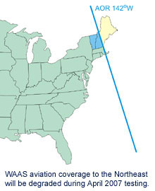 For the duration of the test, WAAS will be unavailable in the Northeast U.S, including all of Maine, New Hampshire, Vermont, Massachusetts, Rhode Island, Connecticut and parts of New York. Accordingly, all uses of WAAS for Instrument Flight Rules (IFR) navigation (including LPV, LNAV/VNAV, and enroute) will be affected for a temporary period in the area impacted by the test. Aviation users should continue to refer to the most recent NOTAMs to determine the level of service at a specific airport.
No impact is expected for the remainder of the U.S. Service will be fully restored no later than April 24th when the test period expires.

Garmin Receives WAAS Certification for GNS 400W/500W series
November 9, 2006 - The GNS 400/500 series have earned the FAA's TSO C146a Gamma-3 certification, which enables pilots who upgrade their Garmin receiver to fly Localizer Performance with Vertical (LPV) guidance approaches and receive GPS navigation via the Wide Area Augmentation System (WAAS). This upgrade will allow thousands of Garmin 400 or 500 series receivers to utilize WAAS starting in 2007. For more information, read the Garmin news release.
WAAS approved for new, lower minimums
March 2006 - In a major step that expands the benefits of satellite navigation for aviation users, the Federal Aviation Administration has announced lower localizer performance with vertical guidance (LPV) approach minima through the use of the Wide Area Augmentation System (WAAS). WAAS is now approved to provide guidance down to 200 feet above an airport's surface for LPV instrument approaches.
- FAA Announces Major Milestone for Wide Area Augmentation System (WAAS)
- AOPA Welcomes Improved WAAS Minima
Please be sure to check out the latest version of the SatNav News available online.
![[Link Brochure ESRS information ]](/sites/faa.gov/files/about/office_org/headquarters_offices/ato/ESRS_334X299.jpg)