An official website of the United States government
Official websites use .gov A .gov website belongs to an official government organization in the United States.
Secure .gov websites use HTTPS
A lock ( ) or https:// means you’ve safely connected to the .gov website. Share sensitive information only on official, secure websites.
Kotzebue RWY 09 Roadway Gate Control Operations - Ralph Wien Memorial Airport, Kotzebue, AK
Updated Monday, September 27, 2010
This page includes further UPDATED (Sep 24th) information about requirements for specific SIAPs.
This is an update from the information previously posted and contained in the Alaska Supplement. The use of the road traffic gate mechanism at Kotzebue is mandatory when flying the ILS, LNAV/VNAV, and LPV RWY 9 SIAPs. It is voluntary for other operations to runway 9.
Please note the date (Sep 24, 2010) at the top of PDF document dowloadable below. If you downloaded any previous versions, please replace them with this one containing the current affected SIAPs.
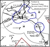
New Traffic Pattern Around the West end of RWY 09 at Ralph Wien Memorial Airport, Kotzebue, AK
Each person operating an aircraft within the Fairbanks Terminal Radar Service Area (TRSA) should operate that aircraft according to the rules set forth in this section unless otherwise authorized or required by ATC.
Each person operation a helicopter shall operate it in a manner so as to avoid the flow of airplanes.
All aircraft while in the Fairbanks Surface Area should fly with their lights on at all times.
Arriving aircraft should contact Fairbanks Approach at least 20 miles from the airport of arrival destination. Arriving traffic northeast through east through southeast of Fairbanks International Airport should contact Fairbanks Approach on 126.5. All other arrivals should contact Fairbanks Approach on 125.35.
All aircraft arriving Fairbanks International Airport on downwind from the north or south remain at least 1 mile east or west of the extended centerlines for Fairbanks International RWYs 2/20.
Fairbanks Traffic Pattern Altitudes
Aircraft arrival/departure altitudes may vary from these listed:
Fairbanks Traffic Pattern Altitudes
Reciprocating-engine
1,500 MSL
Large and turbine powered aircraft
2,000 MSL
Chena Marina Procedures
Arrival/departure/pattern traffic for Chena Marina contact Fairbanks Tower on 118.3.
Chena Marina traffic will observe a ceiling of 1,200 MSL while in the pattern.
Traffic patterns will be to the west of the Chena Marina runway and float pond with Chena Ridge being the western boundary.
All Chena Marina traffic will remain west of Chena Pump Road at or below 1200 MSL and will advise Fairbanks Tower prior to crossing Chena Pump Road eastbound.
Departure traffic remains west of Fairbanks International Airport at all times unless otherwise authorized or required by ATC.
In the interest of safety, please utilize Fairbanks Radar Services whenever departing Chena Marina.
TRSA Services
A. Standard TRSA Departure Instructions
Departing aircraft should monitor the ATIS, then contact Fairbanks Clearance Delivery on the appropriate frequency being broadcast on the ATIS prior to taxi. Pilots are expected to inform the controller of an intended destination and/or initial heading and desired cruising altitude. All departing aircraft will be given TRSA services unless the pilot states "negative TRSA service" or makes a similar comment.
B. TRSA Departure (VFR Departing Aircraft)
The standard TRSA departure for Fairbanks International Airport will be to fly runway heading for the runway assigned, departure frequency on 125.35. This will be referred to as the "TRSA departure". Fairbanks Clearance Delivery will issue to each aircraft: "TRSA departure, squawk (code)".
C. TRSA Service from Float Pond
Clearance Delivery frequency stated on ATIS. Aircraft departing the Float Pond at Fairbanks International Airport should monitor the ATIS, then contact Fairbanks Clearance Delivery for services. Those departing aircraft should then contact Fairbanks Tower 118.3 directly for taxi clearance.
D. TRSA Service from Satelllite Airports
Clearance Delivery frequency stated on ATIS. Aircraft departing satellite airports, inside the Fairbanks Class D surface area, such as Chena Marina, Chena River, Metro Field, and Peger Pond, and requesting TRSA services should monitor the ATIS, then contact Fairbanks Clearance Delivery for TRSA services. Those departing aircraft should then contact Fairbanks Tower directly on 118.3.
Fairbanks TRSA Description
That airspace extending upward from the surface to and including 7,000 feet MSL within a 4.7-mile radius of Eielson AFB (lat. 64° 39' 56" N, long. 147° 06' 05" W), and within 5.4-mile radius of Fairbanks International Airport (lat. 64° 48' 57" N, long. 147° 51' 29" W), and within 5.3-mile radius of Ladd AAF (lat. 64° 50' 11" N, long. 147° 37' 01" W), and within 3.3 miles each side of the 218° bearing and 038° bearing from the Fox NDB (lat. 64° 58' 08" N, long. 147° 34' 48" W) extending from the 5.4-mile radius of the Fairbanks International Airport to 13.5 miles north of the Fairbanks International Airport, and within 2.4 miles each side of the Chena NDB (lat. 64° 50' 17" N, long. 147° 29' 24" W) 089° bearing extending from the 5.3-mile radius of the Ladd AAF to 10.1 miles east of the Ladd AAF and within 1.8 miles north of the Fairbanks VORTAC (lat. 64° 48' 00" N, long. 148° 00' 43" W) 078° radial extending from the 5.3-mile radius of the Ladd AAF to 9.9 miles east of Ladd AAF; excluding the portion of the arrival extension south of a line from lat. 64° 48' 44" N, long. 147° 13' 18" W; to lat. 64° 47' 57" N, long. 147° 21' 23" W; and upward from 2,500 feet MSL to and including 7,000 feet MSL within a 15-mile arc around the Fairbanks Int�l Airport from the centerline of V-480 counterclockwise to the intersection of the 15-mile arc around the Eielson AFB, then counterclockwise along the Eielson AFB 15-mile arc to lat.64° 27� 27" N, long. 146° 47�00" W, then north to the boundary of the Viper MOA at lat. 64° 33� 23"N, long. W146° 46� 09" W then northwest via the Viper MOA Boundary to the intersection of the Eielson Class D surface area, then clockwise along the Eielson Class D surface area to the Viper MOA, then north to the northwest corner of the Viper MOA, then northwest on a direct line to the southeast corner of the Ladd AAF Class E surface area extension, thence clockwise along the Fairbanks, Ladd AAF, and Fairbanks Intl, AK Class D & E surface areas to V-480; and upward from 3,000 feet MSL to and including 7,000 feet MSL within a 15-mile arc around the Fairbanks Int�l Airport from the centerline of V-480 clockwise to lat. 64° 56� 00�N, long. 147° 20� 44"W; thence directly east along lat. 64° 56� 00" N to the boundary of the Yukon 1 MOA, then southwest along the Yukon 1 and Viper MOA�s to the Northwest Corner of the Viper MOA then direct to the Southeast corner of the Ladd AAF Class E4 surface area extension, then counterclockwise along the Fairbanks, Ladd AAF, and Fairbanks Int�l, AK Class D & E surface areas to V-480.
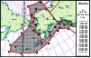
This information is furnished on this web site in order to offer greater situational awareness for pilots operating in the Anchorage Bowl in the vicinity of Anchorage, Ted Stevens International Airport, Merrill Field and Elmendorf AFB.
This same graphic is posted in the Alaska Supplement, in the Notices Section.
In addition to this graphic, which is posted in the Alaska Supplement as the last item in the Procedures section, pilots should be versed on intercept procedures, should they become involved in such an event. Those procedures are listed as the first items in the Emergency Procedures section, immediately following the printed ADIZ graphic. They are provided here as printed in the Sep 23, 2010 edition. However, you should always consult the current edition as this copy will soon become outdated. View The Page Here(PDF, 28 KB)
Increase your chances for a safe flight. Contact your FAA Flight Service Station prior to departure and provide position during your flight. The life you save could be your own.
We are supporting reducing aviation accidents in Alaska by reaching out to pilots, students and operators. We encourage and educate customers on the use and safety enhancing benefits of FAA flight services, i.e. weather briefings, inflight services, emergency services, SVFR operations, flight plan handling, Search and Rescue procedures, AFIS, etc. We conduct flight services safety related outreach activities supporting the reduction of aviation accidents in Alaska to meet or exceed FAA Flight Plan performance targets. Join us in actively reducing accidents.Q: Why use Flights Service Stations?
A: The rate of aviation accidents in Alaska is too high. See the NTSB website for statistics and information.
A: We are a collection and dissemination point for NOTAMs affecting airspace, airports, communications, and navigation. We may have additional information regarding NOTAMs affecting your intended departure point, route and/or destination.
A: We help ensure your safe arrival. When an aircraft is overdue on a flight plan, we initiate search and rescue (SAR) procedures. We also have enhanced SAR methods available through the eSRS program.
A: We are experienced. Our flight service specialists have lived and worked throughout Alaska. We know and understand its challenges.
A: We maintain a continuous weather watch throughout the region, becoming aware of trends that may not be reflected in the forecasts. We interpret satellite images, weather radar, and monitor remotely located weather cameras on a real-time basis. See the Weather Cameras website for locations of cameras.
A: We have the most current Pilot Weather Reports available and encourage you to pass along the conditions you encounter, so that we may share them with other pilots.
A: We provide emergency services. Should you become disoriented or have an inflight emergency, we can provide you with guidance to successfully land.
Slot holder reports reflect the slot allocations as they are historically held. Holder reports do not capture ad hoc schedule adjustments or other short-term changes. The report status date reflects FAA confirmed slot transactions as of that date. In some cases, the reports do not reflect all transfers between mainline carriers marketing flights and the operating regional carriers. Slot holdings are subject to change without notice. Slot operator reports reflect the actual scheduled operation of slots and do not reflect slot holder standings. NOTE: S24 and W24 reports were calculated using an updated algorithm.
The Federal Aviation Administration (FAA) is responsible for administration of airport slot allocation at Washington's Reagan National Airport under 14 CFR part 93, subparts K and S and at John F. Kennedy International Airport and LaGuardia Airport under FAA Orders limiting scheduled operations at those airports. Slot allocation records are maintained by the FAA's Air Traffic Organization and all transfers of slots between operators are subject to prior FAA confirmation in accordance with the applicable rules.
The FAA maintains a list with an informal compilation of transfers of slots other than even, or one-for-one, slot trades at the same airport and excluding transfers between marketing carriers and the carriers operating flights on behalf of the marketing carrier. While the FAA considers the uneven slot transfers more likely than even trades to involve some form of consideration, the FAA has no information on consideration provided, if any, for slot transfers.