
The ILS provides both vertical and lateral guidance information for pilots to allow safe landings to touchdown. The ILS sends information to instruments in the cockpit so that the pilot can maintain a predetermined flight path to the runway in low visibility. In addition, ILSs are used frequently under visual and night conditions to help pilots adhere to the runway centerline to improve safety.
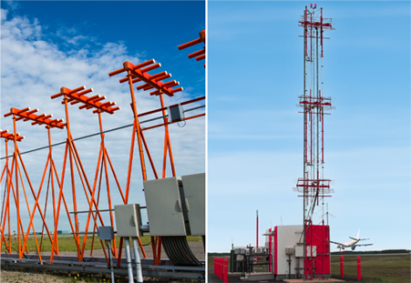
An ILS consists of two separate facilities that operate independently but come together in the cockpit to enable both lateral and vertical precision guidance. A Localizer (LOC) (above left) transmits VHF signals (108.1 MHz to 111.95 MHz) to provide aircraft with lateral guidance that allows pilots to ensure their aircraft is properly aligned with the center of the runway during the approach and landing phases of flight. A Glide Slope (GS) (above right) transmits UHF signals (329.15 MHz to 335.0 MHz) to provide aircraft with vertical guidance enabling a controlled descent to a runway. Working together, these two ILS facilities support a precision approach that ideally, depending on obstacles and terrain, allows aircraft to descend to a Decision Altitude (DA), at which time the pilot must visually recognize the runway environment and continue to a landing or execute a missed approach if the runway environment is not in sight.
The FAA procures systems to sustain Category-I ILSs at selected sites and to sustain and establish Category-II/III ILSs where needed. As the FAA transitions to PBN, ILS systems will continue to provide GPS-independent Category-I/II/III vertically guided approach services. ILS is the only system currently approved for Category II/III operations.
Last updated: