
The Federal Aviation Administration (FAA) IFR Enroute Aeronautical Chart series is designed to meet the needs of users who require a digital version chart. The product is provided as a Portable Document Format (pdf), and available for viewing from this website. The pdf formatted charts are created from their respective native chart files. All information that is part of the paper IFR Enroute aeronautical chart is included in the pdf image.
As each paper Enroute chart is updated, its Geo-tiff and pdf equivalents are updated and available for viewing from this website. Please ensure you are using the most current chart by referring to the chart legend.
Should you discover or encounter an error in any of our products, you are encouraged to contact us immediately. Before you do however, please check the Alerts/Notices webpage to see if the error has been previous discovered or resolved. The FAA has no effective way to contact every individual that has viewed a digital product; therefore, you are requested to check the Alerts/Notices webpage often.
28 and 56 Day Product Schedule (PDF)
(Select the index below to show the coverage of charts series.)
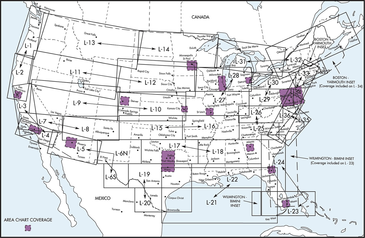
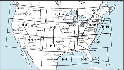
- Enroute High Altitude U.S.
- Enroute Low & High Alaska
- Area Charts U.S.
- Hawaii / Pacific
(Use these drop-down links to get to the various chart series faster.)
| Chart Name | Current Edition Date | Next Edition Date |
|---|---|---|
| ELUS1 | May 14 2026 | Jul 09 2026 GEO-TIFF |
| ELUS2 | May 14 2026 | Jul 09 2026 GEO-TIFF |
| ELUS3 | May 14 2026 | Jul 09 2026 GEO-TIFF |
| ELUS4 | May 14 2026 | Jul 09 2026 GEO-TIFF |
| ELUS5 | May 14 2026 | Jul 09 2026 GEO-TIFF |
| ELUS6 | May 14 2026 | Jul 09 2026 GEO-TIFF |
| ELUS7 | May 14 2026 | Jul 09 2026 GEO-TIFF |
| ELUS8 | May 14 2026 | Jul 09 2026 GEO-TIFF |
| ELUS9 | May 14 2026 | Jul 09 2026 GEO-TIFF |
| ELUS10 | May 14 2026 | Jul 09 2026 GEO-TIFF |
| ELUS11 | May 14 2026 | Jul 09 2026 GEO-TIFF |
| ELUS12 | May 14 2026 | Jul 09 2026 GEO-TIFF |
| ELUS13 | May 14 2026 | Jul 09 2026 GEO-TIFF |
| ELUS14 | May 14 2026 | Jul 09 2026 GEO-TIFF |
| ELUS15 | May 14 2026 | Jul 09 2026 GEO-TIFF |
| ELUS16 | May 14 2026 | Jul 09 2026 GEO-TIFF |
| ELUS17 | May 14 2026 | Jul 09 2026 GEO-TIFF |
| ELUS18 | May 14 2026 | Jul 09 2026 GEO-TIFF |
| ELUS19 | May 14 2026 | Jul 09 2026 GEO-TIFF |
| ELUS20 | May 14 2026 | Jul 09 2026 GEO-TIFF |
| ELUS21 | May 14 2026 | Jul 09 2026 GEO-TIFF |
| ELUS22 | May 14 2026 | Jul 09 2026 GEO-TIFF |
| ELUS23 | May 14 2026 | Jul 09 2026 GEO-TIFF |
| ELUS24 | May 14 2026 | Jul 09 2026 GEO-TIFF |
| ELUS25 | May 14 2026 | Jul 09 2026 GEO-TIFF |
| ELUS26 | May 14 2026 | Jul 09 2026 GEO-TIFF |
| ELUS27 | May 14 2026 | Jul 09 2026 GEO-TIFF |
| ELUS28 | May 14 2026 | Jul 09 2026 GEO-TIFF |
| ELUS29 | May 14 2026 | Jul 09 2026 GEO-TIFF |
| ELUS30 | May 14 2026 | Jul 09 2026 GEO-TIFF |
| ELUS31 | May 14 2026 | Jul 09 2026 GEO-TIFF |
| ELUS32 | May 14 2026 | Jul 09 2026 GEO-TIFF |
| ELUS33 | May 14 2026 | Jul 09 2026 GEO-TIFF |
| ELUS34 | May 14 2026 | Jul 09 2026 GEO-TIFF |
| ELUS35 | May 14 2026 | Jul 09 2026 GEO-TIFF |
| ELUS36 | May 14 2026 | Jul 09 2026 GEO-TIFF |
| Chart Name | Current Edition Date | Next Edition Date |
|---|---|---|
| EHUS1 | May 14 2026 | Jul 09 2026 GEO-TIFF |
| EHUS2 | May 14 2026 | Jul 09 2026 GEO-TIFF |
| EHUS3 | May 14 2026 | Jul 09 2026 GEO-TIFF |
| EHUS4 | May 14 2026 | Jul 09 2026 GEO-TIFF |
| EHUS5 | May 14 2026 | Jul 09 2026 GEO-TIFF |
| EHUS6 | May 14 2026 | Jul 09 2026 GEO-TIFF |
| EHUS7 | May 14 2026 | Jul 09 2026 GEO-TIFF |
| EHUS8 | May 14 2026 | Jul 09 2026 GEO-TIFF |
| EHUS9 | May 14 2026 | Jul 09 2026 GEO-TIFF |
| EHUS10 | May 14 2026 | Jul 09 2026 GEO-TIFF |
| EHUS11 | May 14 2026 | Jul 09 2026 GEO-TIFF |
| EHUS12 | May 14 2026 | Jul 09 2026 GEO-TIFF |
| Chart Name | Current Edition Date | Next Edition Date |
|---|---|---|
| ELAK1 | May 14 2026 | Jul 09 2026 GEO-TIFF |
| ELAK2 | May 14 2026 | Jul 09 2026 GEO-TIFF |
| ELAK3 | May 14 2026 | Jul 09 2026 GEO-TIFF |
| ELAK4 | May 14 2026 | Jul 09 2026 GEO-TIFF |
| EHAK1 | May 14 2026 | Jul 09 2026 GEO-TIFF |
| EHAK2 | May 14 2026 | Jul 09 2026 GEO-TIFF |
| Chart Name | Current Edition Date | Next Edition Date |
|---|---|---|
| Area 1 | May 14 2026 | Jul 09 2026 GEO-TIFF |
| Area 2 | May 14 2026 | Jul 09 2026 GEO-TIFF |
| Chart Name | Current Edition Date | Next Edition Date |
|---|---|---|
| EPHI1 | May 14 2026 | Jul 09 2026 GEO-TIFF |
| EPHI2 | May 14 2026 | Jul 09 2026 GEO-TIFF |
- IFR Enroute Aeronautical Planning Charts Index (An index graphic of the Atlantic and Pacific)
North Pacific Route Charts are designed for FAA Controllers to monitor transoceanic flights. The charts show established intercontinental air routes, including reporting points with geographic positions. Composite Chart 48x41 1/2 inches, Area Charts 52x40 1/2 inches. All charts are shipped unfolded. Revised every 56 days.
North Atlantic Route Chart and the Western Atlantic Route System Chart are designed for FAA Controllers to monitor transatlantic flights, this 5-color chart shows oceanic control areas, coastal navigation aids, oceanic reporting points, NAVAID coordinates and reporting points. Full Size Chart 29 3/4x20 1/2, shipped folded to 5 x 10 inches only. Revised every 56 days.
| Chart Name | Current Edition Date | Next Edition Date |
|---|---|---|
| North Atlantic Route Chart | May 14 2026 | Jul 09 2026 GEO-TIFF |
| North Pacific Route Chart (Composite, Northeast, Northwest, Southeast, and Southwest) | May 14 2026 | Jul 09 2026 GEO-TIFF |
| Western Atlantic Route System Chart | May 14 2026 | Jul 09 2026 GEO-TIFF |
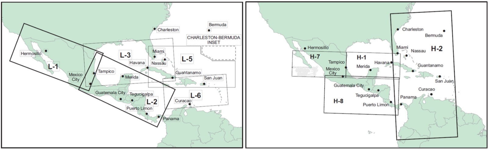
- IFR Enroute Aeronautical Caribbean Charts Index (An index graphic of the Caribbean)
The Federal Aviation Administration (FAA) Out of-CONUS IFR Enroute Aeronautical Chart series is designed to meet the needs of users who require a digital version chart. The products are provided as a Portable Document Format (pdf) and Geo-referenced Tagged Image File Format (GeoTIFF) available for public download. The formatted charts are created from their respective native chart files.
ELCBA1
- Buenos Aires
- Santiago
- Lima
- Rio de Janeiro
- Guatemala City
- Antigua Island — Ascension Island
ELCBA2
- Miami — Nassau
- Bogota
- Mexico City
- Panama
- Central America — Pacific Ocean Inset
ELCBA3
- Dominican Republic/Puerto Rico Area
- Mexico High Inset
| Chart Name | Current Edition Date | Next Edition Date |
|---|---|---|
| ELCB1-2 | May 14 2026 | Jul 09 2026 GEO-TIFF |
| ELCB3/ELCBA3 | May 14 2026 | Jul 09 2026 GEO-TIFF |
| ELCB5-6 | May 14 2026 | Jul 09 2026 GEO-TIFF |
| Chart Name | Current Edition Date | Next Edition Date |
|---|---|---|
| EHCB1-2-7-8 | May 14 2026 | Jul 09 2026 GEO-TIFF |
| Chart Name | Current Edition Date | Next Edition Date |
|---|---|---|
| ELCBA1-2 | May 14 2026 | Jul 09 2026 GEO-TIFF |
| ELCBA3/ELCB3 | May 14 2026 | Jul 09 2026 GEO-TIFF |
The following ZIP files contain all of the Digital Enroute charts, except for Caribbean charts, for a given effective date range. Due to the large file sizes, it is best to download one zip file at a time using a broadband internet connection during off-peak internet hours.
| Current Edition Date | Next Edition Date |
|---|---|
| DDECUS Jul 09 2026 |