
 CHART SUPPLEMENT - A series of civil/military flight information publications issued by FAA every 56 days consisting of the Chart Supplement U.S., Chart Supplement Alaska, and Chart Supplement Pacific.
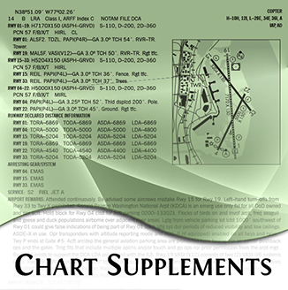
Chart Supplement U.S. This 7-volume book series is designed for use with appropriate IFR or VFR charts and contains data including, but not limited to, airports, NAVAIDs, communications data, weather data sources, special notices, non-regulatory operational procedures, and airport diagrams. Coverage includes the conterminous U.S., Puerto Rico, and the Virgin Islands. The Chart Supplement U.S. shows data that cannot be readily depicted in graphic form; for example, airport hours of operations, types of fuel available, runway widths, lighting codes, etc.
Chart Supplement Alaska This single volume book is designed for use with appropriate IFR or VFR charts. The Chart Supplement Alaska contains data including, but not limited to, airports, NAVAIDs, communications data, weather data sources, special notices, non-regulatory operational procedures, and airport diagrams. The publication also includes uniquely geographical operational requirements such as area notices and emergency procedures.
Chart Supplement Pacific This single volume book is designed for use with appropriate IFR or VFR charts. The Chart Supplement Pacific contains data including, but not limited to, airports, NAVAIDs, communications data, weather data sources, special notices, non-regulatory operational procedures, and airport diagrams. The publication also includes airspace, navigational facilities, non-regulatory Pacific area procedures, Instrument Approach Procedures (IAP), Departure Procedures (DP), Standard Terminal Arrival (STAR) charts, radar minimums, supporting data for the Hawaiian and Pacific Islands, and uniquely geographical operational requirements such as area notices and emergency procedures.
North Pacific Route are designed for FAA Controllers to monitor transoceanic flights. The charts show established intercontinental air routes, including reporting points with geographic positions.
North Atlantic Route is designed for FAA Controllers to monitor transatlantic flights, this 5-color chart shows oceanic control areas, coastal navigation aids, oceanic reporting points.
Gulf of America Vertical Flight is designed for helicopter operations, this 5-color chart depicts and IFR GPS way-point grid system that aids in the direct routing to oil platforms in the gulf.
Aeronautical Chart Users' Guide contains a listing of every charting symbol used on each FAA product and its meaning.