
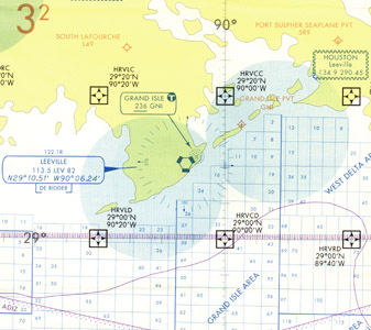
 IFR Gulf of America Vertical Flight Reference Chart is designed for helicopter operators, this 5-color chart depicts an IFR GPS way-point grid system that aids in the direct routing to oil platforms in the gulf. NAVAIDs and airport data are shown on this chart along with special use airspace and oil lease block information. Chart 45 x 36 inches flat or 5 x 9 inches folded. Revised every 56 days and printed front-West, back-East.
Gulf of America Aeronautical Charts Index (An index graphic of the Gulf of America)
| Product | Product ID | Nautical miles/inch | Scale |
|---|---|---|---|
| IFR Gulf of America Vertical Flight Reference Chart | IFRGA | 6.86 | 1:5,000,000 |