
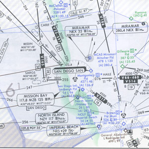
Portion of an Enroute Low Altitude Chart
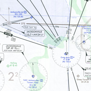
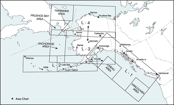
Portion of an Area Chart
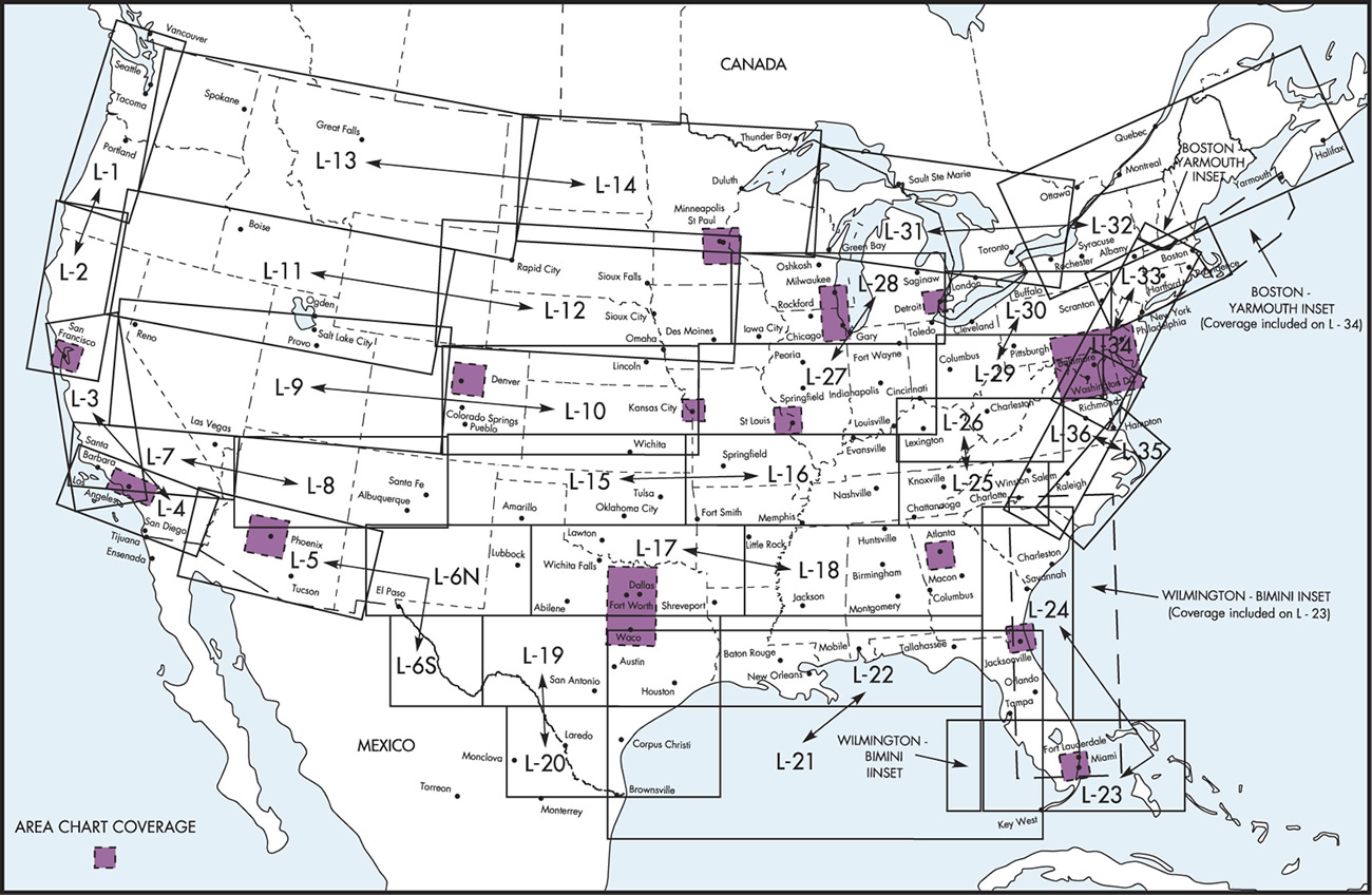
- Conterminous U.S. series of enroute charts
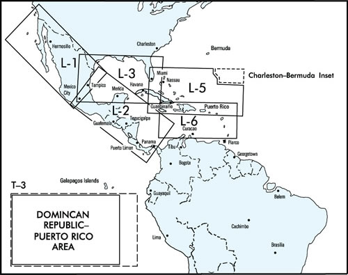
- Caribbean series of enroute charts
- Alaska series of enroute charts
IFR Enroute Low Altitude Charts provide aeronautical information for navigation under instrument flight rules below 18,000 feet MSL. These four-color chart series includes:
- Air Traffic Services
- Airports that have an Instrument Approach Procedure or a minimum 3000' hard surface runway
- Airways/Route Data
- Cruising Altitudes
- Fixes/ATC Reporting Points
- Limits of controlled airspace
- Military Training Routes
- Off Route Obstruction Clearance Altitudes (OROCA)
- Radio aids to navigation
- RNAV Routes
- Special Use Airspace Areas
- Tabulations (MTRs, SUAs, MOAs, Airport data)
Area Charts, which show congested terminal areas at a large scale, are included with subscriptions to any conterminous U.S. Set Low (Full set, East or West sets). Charts are revised every 56 days.
Conterminous U.S. Low Altitude Area Charts
A-1 consists of Area Charts for
- Atlanta (1" = 6 NM)
- Detroit (1" = 5 NM)
- Jacksonville (1" = 6 NM)
- Miami (1" = 6 NM)
- Minneapolis / St. Paul (1" = 6 NM)
- St. Louis (1" = 6 NM)
- Washington (1" = 7 NM)
A-2 consists of Area Charts for
- Chicago / Milwaukee (1" = 6 NM)
- Dallas / Fort Worth (1" = 6 NM)
- Denver (1" = 7 NM)
- Kansas City (1" = 5 NM)
- Los Angeles (1" = 5 NM)
- Phoenix (1" = 8.5 NM)
- San Francisco (1" = 6 NM)
Alaska Low Altitude Area Charts
L-1 consists of Area Charts for
- Juneau (1" = 14 NM)
- Vancouver (1" = 8 NM)
L-2 consists of Area Charts for the Aleutian Islands
- East / King Salmon (1" = 25 NM)
- Central / Cold Bay (1" =2 5 NM)
- West / Adak Island (1" = 25 NM)
Caribbean Area Charts
A-1 consists of Area Charts for
- Buenos Aires (scale 1" = 13 NM)
- Santiago (1" = 12 NM)
- Lima (1" = 18 NM)
- Rio de Janeiro (1" = 10 NM)
- Guatemala City (1" = 17 NM)
- Antigua Island-Ascension Island Inset (1" = 228 NM)
A-2 consists of area charts for
- Miami-Nassau (1"= 19 NM)
- Bogota (1"= 15 NM)
- Mexico City (1" = 23 NM)
- Panama (1" = 8 NM)
- Central America-Pacific Ocean Inset (1" = 52 NM)
A-3 consists of an area chart for
- Dominican Republic/Puerto Rico (1" = 16 NM)
| Chart Type | Nautical miles/inch |
|---|---|
| Instrument Flight Rules (IFR) Enroute Low Altitude Chart for the Conterminous U.S. | Varies from 5 to 20 |
Product Name and FAA Product ID
| Product | Product ID |
|---|---|
| L 1/2 | ELUS1 |
| L 3/4 | ELUS3 |
| L 5/6 | ELUS5 |
| L 7/8 | ELUS7 |
| L 9/10 | ELUS9 |
| L 11/12 | ELUS11 |
| L 13/14 | ELUS13 |
| L 15/16 | ELUS15 |
| L 17/18 | ELUS17 |
| L 19/20 | ELUS19 |
| * L 21/22 | ELUS21 |
| L 23/24 | ELUS23 |
| L 25/26 | ELUS25 |
| L 27/28 | ELUS27 |
| L 29/30 | ELUS29 |
| L 31/32 | ELUS31 |
| L 33/34 | ELUS33 |
| L 35/36 | ELUS35 |
| FULL SET | ELUSSET |
| EAST SET | ELUSE |
| WEST SET | ELUSW |
| A 1/2 | Area |
| * L-21 is intended for offshore navigation only. Detailed onshore information has been intentionally omitted. Refer to charts L-19/20, L-22, L-23/24 for detailed onshore information. | |
| Product | Product ID |
|---|---|
| ALASKA 1/2 | ELAK1 |
| ALASKA 3/4 | ELAK3 |
| FULL SET | ELAKSET |
| Product | Product ID |
|---|---|
| CARIB 1/2 | ELCB1 |
| CARIB 3/A3 | ELCB3 |
| CARIB 5/6 | ELCB5 |
| CARIB A1/A2 | ELCBA1 |
| FULL SET | ELCBSET |