
Convective Weather
Program Overview
Convective weather (CW) causes significant problems in the National Airspace System (NAS) by contributing to delays, reducing safety and making operations less efficient. Furthermore, hazardous weather conditions can be undetectable where traditional ground-based weather radar is obstructed and/or in offshore airspace where there is diminished or no weather radar.
The goal for the Aviation Weather Research Program (AWRP) – Convective Weather Product Development Team (CWPDT) is to develop new techniques and capabilities to detect and forecast convective weather so users can maximize efficiency and safety with minimal delays.
This goal extends beyond the Continental United States (CONUS). The CWPDT is looking at oceanic airspace too where over 22 million square miles of airspace is controlled by the Federal Aviation Administration (FAA) without traditional ground-based weather radar coverage.
The CWPDT seeks to achieve these goals by:
- Increasing the fundamental understanding of how thunderstorms form, behave, and impact the NAS.
- Developing advanced thunderstorm analysis and predictive capabilities.
- Exploring how thunderstorm information is used to make decisions and assess the need for improved information.
- Ensuring that convective weather algorithms, products or methods developed through the AWRP are scientifically accurate, provide value in terms of forecast worth to the individual decision-maker within their operational aviation decision processes and can be transitioned to appropriate FAA system(s).
Ensemble Prediction Oceanic Convective Hazards (EPOCH)
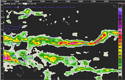
EPOCH is a tool that uses multiple global ensemble forecasts to generate global probabilistic guidance depicting where and when aviation-impacting convective weather is most likely to occur in the strategic planning time frame (12 – 48 hours).
The figure (right) shows a 36-hour forecast depicting the probability of convection over the equatorial Pacific. The contours in purple areas had verified cloud tops above 30kFT.
Current Status: In June 2023, EPOCH became an operational tool within the National Weather Service (NWS) to assist the United States as a World Area Forecast Center (WAFC) to meet international forecasting requirements.
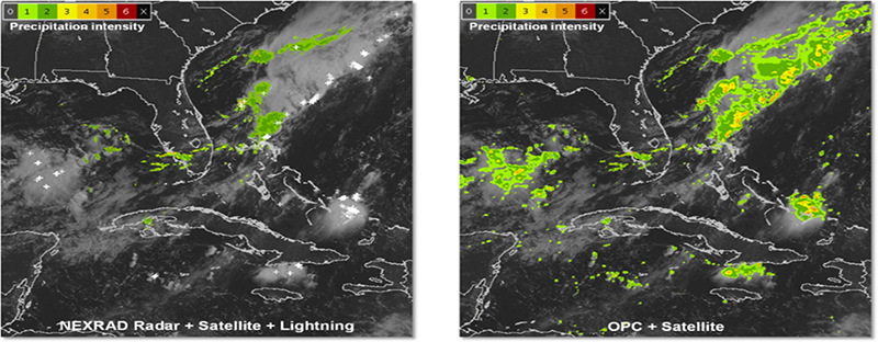
Offshore Precipitation Capability (OPC)
The OPC is FAA funded research to supplement where land-based radar is not possible or provides degraded detection. The image below (left side) shows an example of the extent of land-based NEXRAD weather radar coverage in the Gulf of America and Caribbean Sea. Note how the overlaid satellite imagery and lightning data show the presence of strong weather in the regions beyond the reach of NEXRAD coverage. OPC (right side of image below) fills in the gaps to provide reliable depictions of precipitation and storm height which enhancing safety and efficiency of air traffic control in those regions.
How OPC Works
OPC combines infrared and visible satellite data, global lightning (cloud-to-ground), and atmospheric analysis fields from numerical weather prediction models. Using a machine learning framework, the OPC algorithm is trained in regions where radar and non-radar data are available and then applied in regions without actual weather radar coverage, i.e., to create a synthetic weather radar output. The algorithm produces six-level precipitation intensity and storm echo top height estimates then blends these with existing radar-based systems.
Current Status: OPC is running as a real-time prototype and is available on a website to members of the aviation community, including general aviation, airlines, and FAA air traffic controllers. Feedback from these user groups are being used to further improve the OPC technology. Recent improvements are the expansion of the domain to cover more Atlantic Ocean and Pacific Ocean airspace and inclusion of an 8-hour forecast product, which is a blend of OPC extrapolation and a NOAA weather model. These improvements are available on the OPC Testbed, which is accessible from the OPC web site.