
Turbulence
Since the 1990s, the FAA has been sponsoring research and product development for turbulence mitigation, collaborating with industry to develop products that are operationally useful, and successfully transitioning government-developed products to industry. FAA-funded research and development project tasks are performed by the National Center for Atmospheric Research (NCAR) and other vendors. Industry partners include the National Weather Service, airlines, commercial providers, and airframe manufacturers.
Why is turbulence research important?
NTSB Accidents by Defining Event for 2008-2022
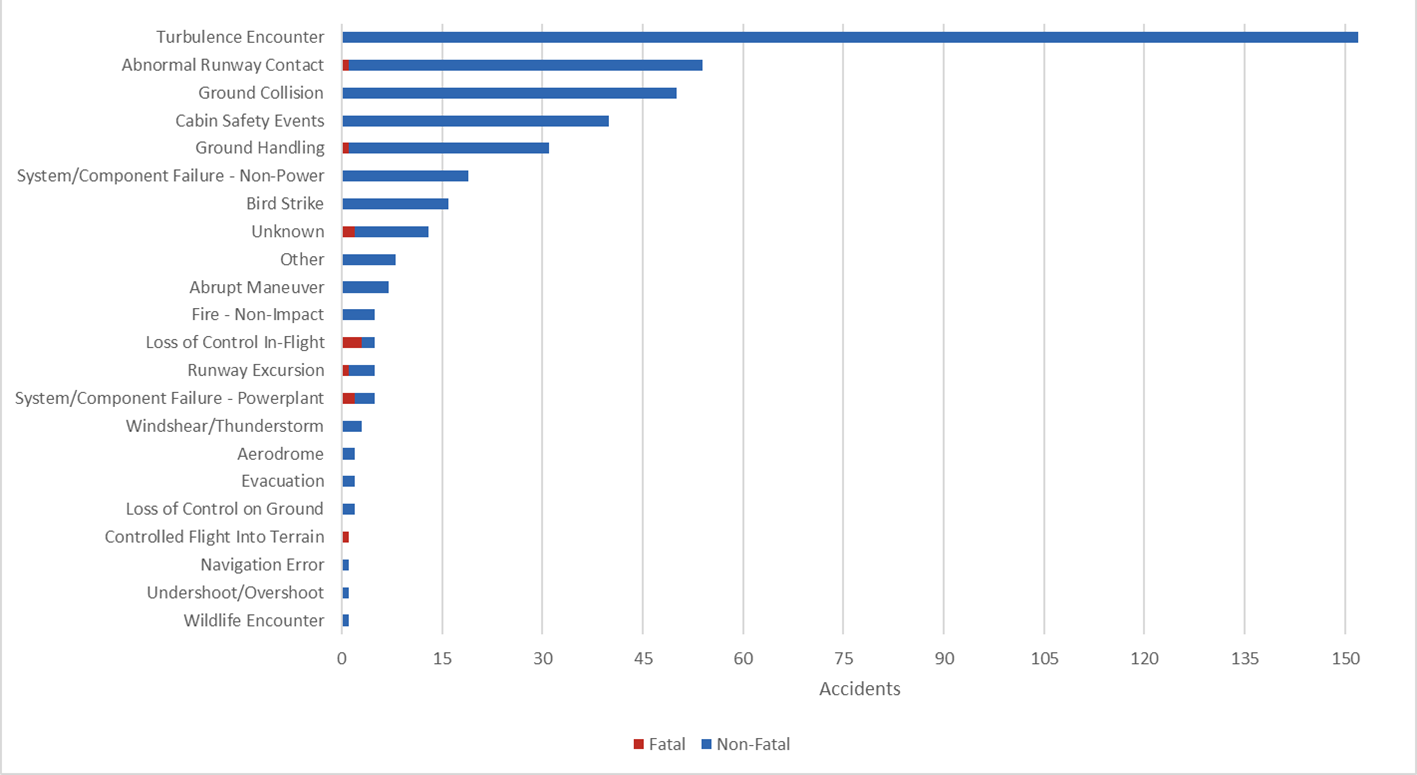
- Turbulence is still the leading cause of accidents among Part 121 air carriers (generally operating large, transport-category aircraft carrying passengers, cargo, or both for hire).
- From 2008 through 2022, turbulence accounted for 152 of 420 (36%) Part 121 accidents.
- Each turbulence-related accident resulted in at least one serious injury.
- While fatal turbulence-related accidents involving Part 121 air carriers are exceedingly rare, Part 91 (General Aviation) operators have had 15 fatal accidents and Part 135 (commuter and on-demand) operators have had 1 fatal accident due to turbulence since 2008.
- The cost of injuries, equipment damage and maintenance/inspection, and rerouting due to turbulence are substantial. One study estimated that the cost of these issues to the airlines is approximately $100 million/year.
What are the goals of the FAA Turbulence Program?
- Enhance safety of the National Airspace System
- Increase efficiency and capacity of the National Airspace System
- Reduce unnecessary rerouting of aircraft due to turbulence, which in turn reduces fuel burn and carbon emissions
- Support global harmonization of turbulence observations and forecasts
What are the main efforts currently led by the FAA Turbulence Program?
- Providing more and improved observations of turbulence
- Improving turbulence forecast products for strategic avoidance and planning
- Operationalizing turbulence nowcast products for tactical avoidance
Turbulence Observations
Better forecasts begin with better observations. Historically, pilot reports (PIREPs) were the only method of observing the location and intensity of turbulence. Because traditional PIREPs are subjective and limited in temporal and spatial resolution, newer methods of objective, aircraft-independent, and near real-time turbulence detection have been developed. These improved observing methods calculate Eddy Dissipation Rate (EDR), an aircraft-independent (applicable across airframe types) measure of the state of the atmosphere.
- In situ EDR algorithm is installed on an aircraft’s avionics systems and uses data from on-board sensors (e.g., winds, pressure) as well as derived information from other existing sensors (e.g., angle of attack, roll angle) to calculate a measure of the atmospheric turbulence that an aircraft is encountering.
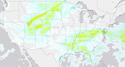
- Next Generation Weather Radar (NEXRAD) Turbulence Detection Algorithm (NTDA) infers in-cloud EDR using spectrum width measured by ground-based radar. NTDA provides an EDR mosaic over the CONUS which updates every 5 minutes. Resolution is 2-km horizontally and 3000-ft vertically.
- Potential new sources of turbulence information include lightning and satellite data, as well as aircraft-based information from the Automatic Dependent Surveillance–Broadcast (ADS-B) system required on aircraft. An algorithm has been developed to calculate EDR using ADS-B vertical rate (VR) data.
Graphical Turbulence Guidance (GTG)
Graphical Turbulence Guidance (GTG) is derived from airborne turbulence observations and National Weather Service model data with no forecaster modifications. GTG computes the results from multiple turbulence algorithms, then compares the results of each algorithm with turbulence observations from PIREPs, AMDAR data, and EDR reports to determine how well each algorithm matches reported turbulence conditions from these sources. GTG then weighs the results of this comparison to produce a single turbulence forecast expressed as EDR. The success of GTG is proportional to the number of in situ reports available to verify the algorithms. This means the accuracy of GTG improves during daylight hours and where there is more traffic.
The current operational version of GTG available over the CONUS is GTG3. GTG3, based on the 13-km RAP model, updates every hour and produces hourly forecasts through 3 hours then three-hourly forecasts through 18 hours. GTG3 forecasts are available at 100 ft MSL, 1000 ft MSL, then every 1000 ft up to FL450. GTG3 produces forecasts of clear air turbulence (CAT), mountain wave turbulence (MWT), and low-level turbulence (LLT).
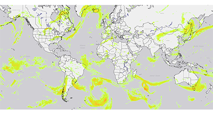
The current operational version of GTG available globally is GTGG. GTGG, based on the 13-km GFS and UKMET models, updates every 6 hours and produces hourly forecasts through 6 hours then distributed forecasts through 48 hours. GTGG forecasts are available at 100 ft MSL, 1000 ft MSL, then every 1000 ft up to FL500. GTGG produces a combined deterministic forecast of clear air turbulence (CAT) and mountain wave turbulence (MWT). A planned upgrade will introduce probabilistic forecasts of CAT and MWT.
The output of GTG is eddy dissipation rate to the one-third power which has units of m⅔ s-1.
GTG Nowcast (GTGN) – Beta
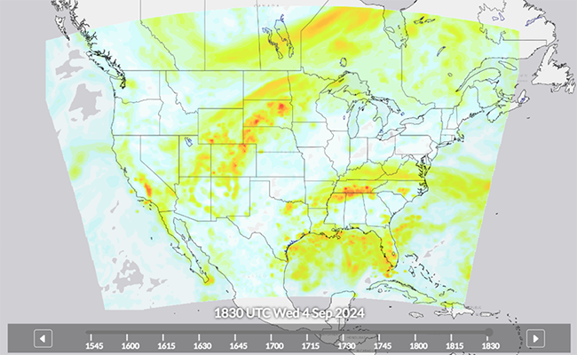
The Graphical Turbulence Guidance Nowcast (GTGN) product has been developed as a tactical aid for aviation. GTGN provides a nowcast of the current turbulent state of the atmosphere over the CONUS in near real-time, updating every 15 minutes. The basis for the nowcast is the most recently available short-term (1 or 2-hour) forecast from the Graphical Turbulence Guidance (GTG) forecast whose valid time is closest to the current update time. Recent observations of turbulence are then used to update the GTG forecast and create a blended nowcast.
Currently, aircraft observations from pilot reports (PIREPs) and automated in situ EDR reports as well as EDR estimated from ground-based radar observations via the NEXRAD Turbulence Detection Algorithm (NTDA) are used.
The GTGN forecast is currently based on NOAA’s 13-km RAP model over the CONUS, though a planned upgrade will replace the RAP model with a 3-km horizontal resolution model. GTGN forecasts are available at 100 ft MSL, 1000 ft MSL, then every 1000 ft up to FL450. GTGN produces a combined forecast of clear air turbulence (CAT), mountain wave turbulence (MWT), and convectively induced turbulence (CIT).
The output of GTGN is eddy dissipation rate to the one-third power which has units of m⅔ s-1.
Future Capabilities
| GTG3 Operational |
GTG4 Planned |
GTG4.5 Planned |
|
|---|---|---|---|
| Domain | CONUS | CONUS | CONUS + Western Atlantic, Eastern Pacific, Alaska |
| Horizontal Resolution | 13 km | 3 km | 3 km |
| Convectively Induced Turbulence Included | No | Yes | Yes |
| AI Techniques Applied | No | No | Yes |
| GTGN Beta |
GTGN2 Planned |
GTGN Global Planned |
|
|---|---|---|---|
| Domain | CONUS | CONUS | Global |
| Horizontal Resolution | 13 km | 3 km | TBD |
| Inputs | GTG3 forecast PIREPs In situ EDR reports NTDA |
GTG4 forecast |
GTGG forecast PIREPs In situ EDR reports NTDA Lightning METAR winds/gusts Satellite |
| Convectively Induced Turbulence Included | Yes | Yes | Yes |
| AI Techniques Applied | No | No | Yes |