
On Airport Unmanned Aircraft System Operations

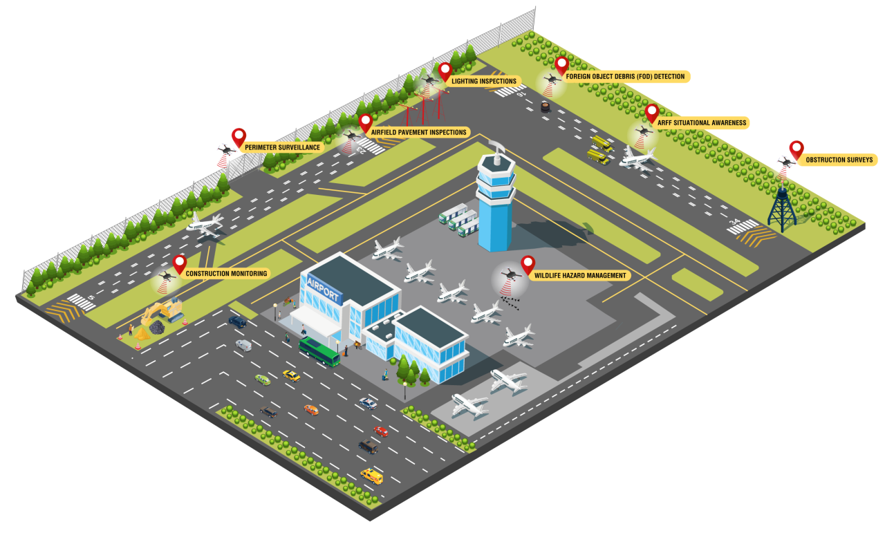
Aerial View of Potential On-airport Applications for Small Unmanned Aircraft Systems
The proliferation of interest in and use of Unmanned Aircraft Systems (UAS), or drones, has led to significant policy and regulatory adaptations to integrate these platforms into the airport environment. As the technology and its use continues to mature, the FAA is committed to conducting research and providing policy and guidance to ensure the safe operation of UAS on-airports.
- Letter to Airport Sponsors about Policies and General Best Practices for UAS Activities On Airports
Provides an overview of policies and general best practices regarding on airport UAS activities. - Letter to Airport Sponsors about Using UAS to Disperse Wildlife
Provides an overview for the use of unmanned aircraft systems (UAS) in dispersing wildlife at an airport and related permitting requirements under the Airborne Hunting Act (AHA), in conjunction with an airport’s Part 139 Wildlife Hazard Management Plan or wildlife program.
For questions about UAS registration, airspace authorization, waivers, law enforcement resources and more, visit www.faa.gov/uas/.
| Office | Contacts |
|---|---|
| FAA Airports Emerging Entrants Division | Mike DiPilato, Program Manager 609-485-7249 Michael.DiPilato@faa.gov |
| FAA Technical Center | Garrison Canter, UAS Research Lead Garrison.J.Canter@faa.gov |
| Airports Regional Contacts | Alaskan Central (IA, KS, MO, NE) Eastern (DC, DE, MD, NJ, NY, PA, VA, WV) Great Lakes (IL, IN, MI, MN, ND, OH, SD, WI) New England (CT, ME, MA, NH, RI, VT) Northwest Mountain (CO, ID, MT, OR, UT, WA, WY) Southern (AL, FL, GA, KY, MS, NC, PR, SC, TN, VI) Southwest (AR, LA, NM, OK, TX) Western-Pacific (AZ, CA, HI, NV, GU, AS, MH) |
Additional Information
- UAS Integration and Application at Airports
- UAS Detection, Mitigation and Response on Airports
- Hot Topics in UAS
The following two buttons apply to both the FAQs and Related Research and Articles sections:
FAQs
A: Please refer to the Airport Sponsor Letter and its attachments.
A: While JO 7200.23, Processing of Unmanned Aircraft Systems Requests, requires FAA’s ATO to verify that the airport sponsor approves of the on-airport request, there is no regulatory provision that requires UAS operators to notify airport sponsors if there are plans to operate near airports in uncontrolled airspace.
A: As the owner/operator of the airport property, airport sponsors have the authority to approve or disapprove a sUAS operation requesting access to operate from on airport.
Any sUAS operator, including the airport authority or a contractor working on their behalf, proposing to fly on airport must submit the authorization request through the FAADroneZone website; LAANC cannot be used to request authorization for on airport operations.
A: UAS cannot be used as the only means of performing self-inspections at this time. An Airport Operator may use UAS as an additional tool when completing their required FAA approved self-inspections, but they must still conduct their Part 139 Self-Inspections as defined in the FAA approved Airport Certification Manual. Research and testing is ongoing to help develop and establish new standards that relate to this topic. Until research is complete, and guidance and standards for use of sUAS in these applications are formalized, sUAS cannot be used as a sole means of compliance with federal regulations and requirements and must be supplemented by traditional methods.
A: Land and water-based unmanned vehicles and aircraft dedicated to mitigating wildlife hazards (e.g., chase, harassment, dispersal) are only occasionally used because other mitigation techniques (e.g., pyrotechnics) frequently can offer faster, equally effective results. UAS have the added dimension of monitoring wildlife hazards plus their ability to effectively harass birds representing large, individual hazards or flocking hazards make them an exceptional stratagem for the tool-kit.
Ensure all applicable stakeholders are part of the implementation planning to include, but not limited to: Airport Sponsor, Air Traffic Manager, Operations, Engineering, Police, ARFF, TSA, etc.
Any type of harassment or mitigation requires the appropriate USDA depredation permit(s).
A: Research is underway to identify means of using UAS for airport obstruction survey. At this time, UAS may not be used as a sole means of conducting surveys.
Surveys must conform to the requirements of the FAA’s Airport GIS Advisory Circulars 150/5300-16, 150/5300-17, and 150/5300-18.
Ensure all applicable stakeholders are part of the implementation planning to include, but not limited to: Airport Sponsor, Air Traffic Manager, Operations, Engineering, Police, ARFF, TSA, etc.
A: Research has found that UAS are useful for supplementing traditional perimeter inspection methods, but cannot be used as a sole means of compliance with FAA regulations and requirements at the current time due to limitations in UAS and camera technology. Implementation for the use of UAS for this purpose may need to be tied to the sponsors Security Program.
Ensure all applicable stakeholders are part of the implementation planning to include, but not limited to: Airport Sponsor, Air Traffic Manager, Operations, Engineering, Police, ARFF, TSA, etc.
A: While a tether may enhance the controllability of a UAS, a tether can present other unique challenges in the airport environment.
The FAA continues to assess the safe implementation of tethered UAS operations in the airport environment. UAS operations in controlled airspace, including tethered operations, require air traffic control approval.
If a tethering system will be used to ensure the UA remains within an approved flight area, the tethering system should have the following characteristics:
- Base Station Weight: The tether system base station should be of sufficient weight to ensure the UA is unable to move or drag the base station of the tether.
- Tensile Strength: The tensile strength of the tether should be adequate to ensure the UA will not be able to break the tether.
- Attachment to UA: The tether should be physically secured to the UA in a manner that ensures the UA will remain attached throughout flight operations.
- Conspicuity: The tether base station should be marked with highly reflective traffic cones (weighted or sturdily attached to the surface) to enhance visibility to ground vehicle operators.
- RF Emissions (If tether is energized): Ensure that the tether does not cause electromagnetic interference that could disrupt airport and aircraft communication, navigation, and surveillance systems.
Please refer to Air Traffic Organization JO 7200.23 - Processing of Unmanned Aircraft Systems Requests to review additional information and submit the applicable authorization request.
A: There is no such thing as a “no fly zone” other than areas that have been designated as prohibited airspace in the interest of national security and temporary flight restrictions. Currently, only federal properties are eligible to be on the Security Sensitive Airspace Restriction list. Federal entities must contact the Department of Energy, Department of Interior, or Department of Defense, as applicable, to see if those departments want to include the facility on the list. The decision is not the FAA's.
UAS Guidance & Resources
Regulations and Policy
- 14 CFR Part 107: UAS registration, airmen certification, and operation
- Order JO 7200.23 – Processing of Unmanned Aircraft Systems Requests
On or Near Airport
Airspace Authorizations
- FAADroneZone: UAS rules, registration, waiver, authorization, report an accident
- Operational Waiver Application Instructions (PDF)
- Certificates of Waiver or Authorization (COA)
- Low Altitude Authorization and Notification Capability (LAANC)
- UAS Facility Maps
- Recreational Flyers and Modeler Community-Based Organizations
Related Research and Articles
- Evaluation of Unmanned Aircraft Systems for Live Monitoring to Enhance Situational Awareness During an Aircraft Rescue and Firefighting Response (FAA)
The Federal Aviation Administration (FAA) Airport Technology Research and Development Branch conducted a research effort to explore the use of small unmanned aircraft systems (UASs) to improve the situational awareness and effectiveness of aircraft rescue and firefighting (ARFF) personnel when monitoring the response to an ongoing ARFF accident/incident. The purpose of this effort was to develop minimum recommended performance specifications and technical/operational considerations for the use of UAS to aid ARFF response. - Evaluation of Unmanned Aircraft Systems for Aircraft Accident and Incident Scene Documentation
The objectives of this research effort supported a better understanding for the potential benefits and limitations of UAS to support accident and incident documentation. Findings of the research led to recommended minimum performance specifications and technical and operational considerations for using UAS to generate orthomosaic maps that may prove useful to ARFF, NTSB, and others with a role in response to a scene that requires investigation and documentation. The objectives of this research effort supported a better understanding for the potential benefits and limitations of UAS to support accident and incident documentation. Findings of the research led to recommended minimum performance specifications and technical and operational considerations for using UAS to generate orthomosaic maps that may prove useful to ARFF, NTSB, and others with a role in response to a scene that requires investigation and documentation.
- Evaluation of Unmanned Aircraft Systems for Airport Perimeter Inspections and Surveillance
A research effort to evaluate the use of UAS for airport perimeter inspections and surveillance found UAS equipped with thermal and visual cameras can provide benefits to airport personnel responsible for inspecting hard-to-reach or inaccessible areas and the ability to detect persons or vehicles. Results of the research recommend that UAS be used to supplement, rather than replace, current methods of conducting visual inspections of airport perimeters.
- Evaluation of Unmanned Aircraft Systems for Airport Obstacle Data Collection
UAS obstacle data collection was conducted at five airports using a variety of UAS platforms, camera payloads, and data collection parameters. These data sets were processed using two types of aerial triangulation (AT) software and analyzed using three-dimensional (3D) stereoscopic analysis techniques. The UAS data sets were evaluated based on their image quality, completeness, and accuracy relative to current FAA standards. The accuracies of UAS-derived obstacle measurements were evaluated by comparing them with data sets collected using field survey techniques and aerial surveys utilizing manned aircraft. The results of both FAA and NGS review of the data found that UAS aerial imagery, in conjunction with 3D stereo analysis, is capable of collecting obstacle measurement data that meets current FAA Advisory Circulars 150/5300-17 and 150/5300-18 accuracy standards. The Office of Airports is currently evaluating the integration of the findings within the report into current policy and standard practice for obstacle data reporting.
- Assessment of Small Unmanned Aircraft Systems for Pavement Inspections
Pavement inspections play an integral role in ensuring airport safety. The FAA Airport Technology Research and Development (ATR) branch performed research to assess the integration of small Unmanned Aircraft Systems (sUAS) into an airport’s Pavement Management Program (PMP). To conduct sUAS-based pavement inspections, the research team tested across five different airports between 2020 and 2022. The objective was to provide a repeatable set of processes and procedures for data collection, analysis, and reporting for sUAS-based pavement inspections. This report presents sUAS data collection parameters, data processing techniques, and data analysis, as well as workflows associated with each inspection. A summary of distresses identifiable via sUAS is also provided. - Practical Lessons Learned from Planning, Collecting, Processing, and Analyzing Small Unmanned Aircraft System Data for Airfield Pavement Inspection (FAA)
A small unmanned aircraft system (sUAS) or drone has proven to be a valuable tool for civil infrastructure inspection, highway inspection, unpaved road inspection, bridge inspection, construction work progress monitoring, and other applications. Additionally, several proof-of-concept studies showed that sUAS could be helpful for airfield pavement distress detection. This report documents a comprehensive study that evaluated the usefulness of sUAS-collected data in detection and rating both asphalt concrete and Portland cement concrete pavement distresses. - Small Unmanned Aircraft System for Pavement Inspection: Task 4—Execute the Field Demonstration Plan and Analyze the Collected Data (FAA)
The primary objectives of this research project are to develop recommended processes and procedures for using small unmanned/uncrewed aircraft system (sUAS) to complement current methods of airport Pavement Management Program (PMP) inspections and to evaluate various types of sUAS platforms and sensors that will lead to recommended minimum specifications required for consistently safe, reliable, and effective sUAS-assisted airport PMP inspections. - Small Unmanned Aircraft System for Pavement Inspection
The use of small Unmanned Aircraft Systems (sUAS) has attracted attention as an option for performing cost-effective and efficient pavement inspections. In this study, the research team deployed several sUAS at six airports in Michigan, Illinois, Iowa, and New Jersey. Different data types were processed and analyzed to assess their usefulness in airfield pavement distress detection and rating. The research team’s analysis showed that a combination of high-resolution orthophotos, digital elevation models derived from photogrammetry, and thermal data can be used to identify certain pavement distresses. However, the current technology does not yet fully offer the capability to detect and rate some low-severity distresses (alkali-silica reaction, corner spalling, joint spalling, joint seal damage, depression, raveling, swell, and weathering). This research did help establish guidelines for sUAS operations for pavement inspection, such as deployment of smaller sUAS for fast red, green, blue (RGB) data collection; deployment of a larger platform for very high-resolution data collection; having a minimum of three people on the data collection team; and the use of ground control points to ensure high-quality orthophotos. In the future, more sUAS platforms and sensors can be evaluated, and tools for automated pavement inspection may be developed using sUAS data.
- Controllable factors affecting accuracy and precision of human identification of animals from drone imagery
Surveying animal populations using drones (unoccupied aircraft systems [UAS]) provides numerous advantages; however, few best practices exist to survey animal communities with drones. This research provides recommendations for improving human accuracy in identifying and counting animals from drone images used in monitoring animal populations and communities. - Evidence on the efficacy of small unoccupied aircraft systems (UAS) as a survey tool for North American terrestrial, vertebrate animals: a systematic map
Small unoccupied aircraft systems (UAS) are replacing or supplementing occupied aircraft and ground-based surveys in animal monitoring due to improved sensors, efficiency, costs, and logistical benefits. Numerous UAS and sensors are available and have been used in various methods. This research presents a systematic map that collects and consolidates evidence pertaining to UAS monitoring of animals. - Investigating nocturnal UAS treatments in an applied context to prevent gulls from nesting on rooftops
Ring-billed (Larus delawarensis) and herring (L. argentatus) gulls are numerous and widespread in North America. These gulls rank among the top 9 species for risk of bird-aircraft collisions (hereafter strikes). The ubiquitous presence of gulls in urban coastal environments, including rooftop nesting behavior, are factors impacting strike risk. The purpose of this research was to assess gull response to a small uncrewed aircraft system (UAS) in hazing flights at night during the nest-building phase. - Testing a Key Assumption of Using Drones as Frightening Devices: Do Birds Perceive Drones as Risky?
Wildlife managers have recently suggested the use of unmanned aircraft systems or drones as nonlethal hazing tools to deter birds from areas of human-wildlife conflict. The research goal was to establish the degree to which the perception of risk by birds would vary between common drone platforms relative to a predator model when flown at different approach types. - Responses of Turkey Vultures to Unmanned Aircraft Systems Vary by Platform
A challenge that conservation practitioners face is manipulating behavior of nuisance species. The turkey vulture (Cathartes aura) can cause substantial damage to aircraft if struck. The goal of this study was to assess vulture responses to unmanned aircraft systems (UAS) for use as a possible dispersal tool.
- Airports and Unmanned Aircraft Systems, Volume 1: Managing and Engaging Stakeholders on UAS in the Vicinity of Airport
- Airports and Unmanned Aircraft Systems, Volume 2: Incorporating UAS into Airport Infrastructure – Planning Guidebook
- Airports and Unmanned Aircraft Systems, Volume 3: Potential Use of UAS by Airport Operators
- Automated Pavement Condition Survey Practices at Airports