Colorado
Denver, Colorado
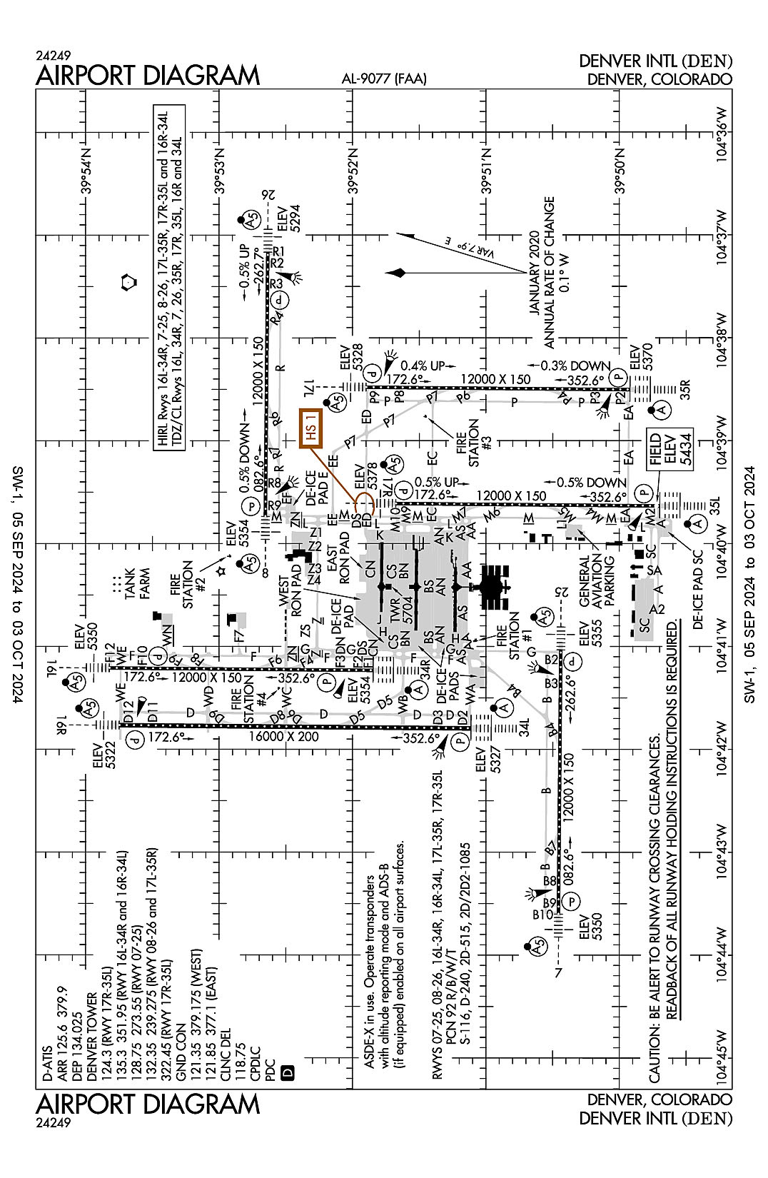
Denver International
ICAO Identifier KDEN
Denver, CO
Denver Intl
ICAO Identifier KDEN
AD 2.2 Aerodrome Geographical and Administrative Data
2.2.1 Reference Point: 39-51-42N / 104-40-23.4W
2.2.2 From City: 16 miles NE of DENVER, CO
2.2.3 Elevation: 5433.8 ft
2.2.5 Magnetic Variation: 8E (2015)
2.2.6 Airport Contact: PHIL WASHINGTON
ADMIN BLDG, 8500 PENA BLVD
DENVER, CO 80249 ((303) 342-2206)
2.2.7 Traffic: IFR/VFR
AD 2.3 Attendance Schedule
2.3.1 All Months, All Days, All Hours
AD 2.4 Handling Services and Facilities
2.4.1 Cargo Handling Facilities: NO
2.4.2 Fuel Types: 100LL A
2.4.5 Hangar Space: YES
2.4.6 Repair Facilities: MAJOR
AD 2.6 Rescue and Firefighting Services
2.6.1 Aerodrome Category: Class-I certified on 2/1/1995
2.6.2 Rescue and Firefighting Services: ARFF Index-E
AD 2.12 Runway Physical Characteristics
2.12.1 Designation: 25
2.12.2 True Bearing: 271
2.12.3 True Dimensions: 12000 ft x 150 ft
2.12.4 PCN: 92 R/B/W/T
2.12.5 Coordinates: 39-50-26.3667N / 104-41-02.1712W
2.12.6 Threshold Elevation: 5355
2.12.6 Touchdown Zone Elevation: 5355
2.12.1 Designation: 07
2.12.2 True Bearing: 90
2.12.3 True Dimensions: 12000 ft x 150 ft
2.12.4 PCN: 92 R/B/W/T
2.12.5 Coordinates: 39-50-27.4022N / 104-43-35.963W
2.12.6 Threshold Elevation: 5350.2
2.12.6 Touchdown Zone Elevation: 5351.6
2.12.1 Designation: 26
2.12.2 True Bearing: 271
2.12.3 True Dimensions: 12000 ft x 150 ft
2.12.4 PCN: 92 R/B/W/T
2.12.5 Coordinates: 39-52-38.0769N / 104-37-10.1479W
2.12.6 Threshold Elevation: 5294.4
2.12.6 Touchdown Zone Elevation: 5309.4
2.12.1 Designation: 08
2.12.2 True Bearing: 91
2.12.3 True Dimensions: 12000 ft x 150 ft
2.12.4 PCN: 92 R/B/W/T
2.12.5 Coordinates: 39-52-39.2009N / 104-39-44.0267W
2.12.6 Threshold Elevation: 5354.3
2.12.6 Touchdown Zone Elevation: 5354.3
2.12.1 Designation: 16L
2.12.2 True Bearing: 181
2.12.3 True Dimensions: 12000 ft x 150 ft
2.12.4 PCN: 92 R/B/W/T
2.12.5 Coordinates: 39-53-49.3301N / 104-41-12.4998W
2.12.6 Threshold Elevation: 5349.9
2.12.6 Touchdown Zone Elevation: 5357.1
2.12.1 Designation: 34R
2.12.2 True Bearing: 1
2.12.3 True Dimensions: 12000 ft x 150 ft
2.12.4 PCN: 92 R/B/W/T
2.12.5 Coordinates: 39-51-50.7743N / 104-41-13.8782W
2.12.6 Threshold Elevation: 5353.7
2.12.6 Touchdown Zone Elevation: 5353.7
2.12.1 Designation: 16R
2.12.2 True Bearing: 181
2.12.3 True Dimensions: 16000 ft x 200 ft
2.12.4 PCN: 92 R/B/W/T
2.12.5 Coordinates: 39-53-44.869N / 104-41-45.9006W
2.12.6 Threshold Elevation: 5321.8
2.12.6 Touchdown Zone Elevation: 5326.3
2.12.1 Designation: 34L
2.12.2 True Bearing: 1
2.12.3 True Dimensions: 16000 ft x 200 ft
2.12.4 PCN: 92 R/B/W/T
2.12.5 Coordinates: 39-51-06.7926N / 104-41-47.7166W
2.12.6 Threshold Elevation: 5327
2.12.6 Touchdown Zone Elevation: 5327
2.12.1 Designation: 35R
2.12.2 True Bearing: 1
2.12.3 True Dimensions: 12000 ft x 150 ft
2.12.4 PCN: 92 R/B/W/T
2.12.5 Coordinates: 39-49-55.2707N / 104-38-30.1554W
2.12.6 Threshold Elevation: 5370
2.12.6 Touchdown Zone Elevation: 5370
2.12.1 Designation: 17L
2.12.2 True Bearing: 181
2.12.3 True Dimensions: 12000 ft x 150 ft
2.12.4 PCN: 92 R/B/W/T
2.12.5 Coordinates: 39-51-53.8287N / 104-38-28.6959W
2.12.6 Threshold Elevation: 5328.1
2.12.6 Touchdown Zone Elevation: 5338.5
2.12.1 Designation: 17R
2.12.2 True Bearing: 181
2.12.3 True Dimensions: 12000 ft x 150 ft
2.12.4 PCN: 92 R/B/W/T
2.12.5 Coordinates: 39-51-40.4821N / 104-39-36.5561W
2.12.6 Threshold Elevation: 5377.9
2.12.6 Touchdown Zone Elevation: 5391.9
2.12.1 Designation: 35L
2.12.2 True Bearing: 1
2.12.3 True Dimensions: 12000 ft x 150 ft
2.12.4 PCN: 92 R/B/W/T
2.12.5 Coordinates: 39-49-41.9262N / 104-39-37.9841W
2.12.6 Threshold Elevation: 5433.8
2.12.6 Touchdown Zone Elevation: 5433.8
AD 2.13 Declared Distances
2.13.1 Designation: 25
2.13.2 Take-off Run Available: 12000
2.13.3 Take-off Distance Available: 13000
2.13.4 Accelerate-Stop Distance Available: 12000
2.13.5 Landing Distance Available: 12000
2.13.1 Designation: 07
2.13.2 Take-off Run Available: 12000
2.13.3 Take-off Distance Available: 12000
2.13.4 Accelerate-Stop Distance Available: 12000
2.13.5 Landing Distance Available: 12000
2.13.1 Designation: 26
2.13.2 Take-off Run Available: 12000
2.13.3 Take-off Distance Available: 12000
2.13.4 Accelerate-Stop Distance Available: 12000
2.13.5 Landing Distance Available: 12000
2.13.1 Designation: 08
2.13.2 Take-off Run Available: 12000
2.13.3 Take-off Distance Available: 13000
2.13.4 Accelerate-Stop Distance Available: 12000
2.13.5 Landing Distance Available: 12000
2.13.1 Designation: 16L
2.13.2 Take-off Run Available: 12000
2.13.3 Take-off Distance Available: 12000
2.13.4 Accelerate-Stop Distance Available: 12000
2.13.5 Landing Distance Available: 12000
2.13.1 Designation: 34R
2.13.2 Take-off Run Available: 12000
2.13.3 Take-off Distance Available: 13000
2.13.4 Accelerate-Stop Distance Available: 12000
2.13.5 Landing Distance Available: 12000
2.13.1 Designation: 16R
2.13.2 Take-off Run Available: 16000
2.13.3 Take-off Distance Available: 16000
2.13.4 Accelerate-Stop Distance Available: 16000
2.13.5 Landing Distance Available: 16000
2.13.1 Designation: 34L
2.13.2 Take-off Run Available: 16000
2.13.3 Take-off Distance Available: 16000
2.13.4 Accelerate-Stop Distance Available: 16000
2.13.5 Landing Distance Available: 16000
2.13.1 Designation: 35R
2.13.2 Take-off Run Available: 12000
2.13.3 Take-off Distance Available: 12000
2.13.4 Accelerate-Stop Distance Available: 12000
2.13.5 Landing Distance Available: 12000
2.13.1 Designation: 17L
2.13.2 Take-off Run Available: 12000
2.13.3 Take-off Distance Available: 12000
2.13.4 Accelerate-Stop Distance Available: 12000
2.13.5 Landing Distance Available: 12000
2.13.1 Designation: 17R
2.13.2 Take-off Run Available: 12000
2.13.3 Take-off Distance Available: 12000
2.13.4 Accelerate-Stop Distance Available: 12000
2.13.5 Landing Distance Available: 12000
2.13.1 Designation: 35L
2.13.2 Take-off Run Available: 12000
2.13.3 Take-off Distance Available: 12000
2.13.4 Accelerate-Stop Distance Available: 12000
2.13.5 Landing Distance Available: 12000
AD 2.14 Approach and Runway Lighting
2.14.1 Designation: 25
2.14.2 Approach Lighting System: MALSR
2.14.4 Visual Approach Slope Indicator System: P4L
2.14.1 Designation: 07
2.14.2 Approach Lighting System: MALSR
2.14.4 Visual Approach Slope Indicator System: P4R
2.14.1 Designation: 26
2.14.2 Approach Lighting System: MALSR
2.14.4 Visual Approach Slope Indicator System: P4L
2.14.1 Designation: 08
2.14.2 Approach Lighting System: MALSR
2.14.4 Visual Approach Slope Indicator System: P4L
2.14.1 Designation: 16L
2.14.2 Approach Lighting System: MALSR
2.14.4 Visual Approach Slope Indicator System: P4L
2.14.1 Designation: 34R
2.14.2 Approach Lighting System: ALSF2
2.14.4 Visual Approach Slope Indicator System: P4L
2.14.1 Designation: 16R
2.14.2 Approach Lighting System: MALSR
2.14.4 Visual Approach Slope Indicator System: P4R
2.14.1 Designation: 34L
2.14.2 Approach Lighting System: ALSF2
2.14.4 Visual Approach Slope Indicator System: P4L
2.14.1 Designation: 35R
2.14.2 Approach Lighting System: ALSF2
2.14.4 Visual Approach Slope Indicator System: P4R
2.14.1 Designation: 17L
2.14.2 Approach Lighting System: MALSR
2.14.4 Visual Approach Slope Indicator System: P4L
2.14.1 Designation: 17R
2.14.2 Approach Lighting System: MALSR
2.14.4 Visual Approach Slope Indicator System: P4L
2.14.1 Designation: 35L
2.14.2 Approach Lighting System: ALSF2
2.14.4 Visual Approach Slope Indicator System: P4R
AD 2.18 Air Traffic Services Communication Facilities
2.18.1 Service Designation: CD/P
2.18.3 Channel: 118.75
2.18.5 Hours of Operation: 24
2.18.1 Service Designation: D-ATIS (ARR)
2.18.3 Channel: 125.6
2.18.5 Hours of Operation: 24
2.18.1 Service Designation: D-ATIS (DEP)
2.18.3 Channel: 134.025
2.18.5 Hours of Operation: 24
2.18.1 Service Designation: D-ATIS (ARR)
2.18.3 Channel: 379.9
2.18.5 Hours of Operation: 24
2.18.1 Service Designation: EMERG
2.18.3 Channel: 121.5
2.18.5 Hours of Operation:
2.18.1 Service Designation: EMERG
2.18.3 Channel: 243
2.18.5 Hours of Operation:
2.18.1 Service Designation: GND/P (WEST)
2.18.3 Channel: 121.35
2.18.5 Hours of Operation: 24
2.18.1 Service Designation: GND/P (EAST)
2.18.3 Channel: 121.85
2.18.5 Hours of Operation: 24
2.18.1 Service Designation: GND/P (EAST)
2.18.3 Channel: 377.1
2.18.5 Hours of Operation: 24
2.18.1 Service Designation: GND/P (WEST)
2.18.3 Channel: 379.175
2.18.5 Hours of Operation: 24
2.18.1 Service Designation: LCL/P (RWY 17R/35L)
2.18.3 Channel: 124.3
2.18.5 Hours of Operation: 24
2.18.1 Service Designation: LCL/P (RWY 07/25)
2.18.3 Channel: 128.75
2.18.5 Hours of Operation: 24
2.18.1 Service Designation: LCL/P (RWY 08/26, 17L/35R)
2.18.3 Channel: 132.35
2.18.5 Hours of Operation: 24
2.18.1 Service Designation: LCL/P (RWY 16L/34R, 16R/34L)
2.18.3 Channel: 135.3
2.18.5 Hours of Operation: 24
2.18.1 Service Designation: LCL/P (RWY 08/26, 17L/35R)
2.18.3 Channel: 239.275
2.18.5 Hours of Operation: 24
2.18.1 Service Designation: LCL/P (RWY 07/25)
2.18.3 Channel: 273.55
2.18.5 Hours of Operation: 24
2.18.1 Service Designation: LCL/P (RWY 17R/35L)
2.18.3 Channel: 322.45
2.18.5 Hours of Operation: 24
2.18.1 Service Designation: LCL/P (RWY 16L/34R, 16R/34L)
2.18.3 Channel: 351.95
2.18.5 Hours of Operation: 24
AD 2.19 Radio Navigation and Landing Aids
2.19.1 ILS Type: DME for runway 07. Magnetic variation: 8E
2.19.2 ILS Identification: DZG
2.19.5 Coordinates: 39-50-23.6632N / 104-40-48.6232W
2.19.6 Site Elevation: 5359.1 ft
2.19.1 ILS Type: Glide Slop for runway 07. Magnetic variation: 8E
2.19.2 ILS Identification: DZG
2.19.5 Coordinates: 39-50-23.2656N / 104-43-22.6558W
2.19.6 Site Elevation: 5340.5 ft
2.19.1 ILS Type: Localizer for runway 07. Magnetic variation: 8E
2.19.2 ILS Identification: DZG
2.19.5 Coordinates: 39-50-26.2755N / 104-40-49.0613W
2.19.6 Site Elevation: 5354.9 ft
2.19.1 ILS Type: DME for runway 25. Magnetic variation: 8E
2.19.2 ILS Identification: ERP
2.19.5 Coordinates: 39-50-23.6632N / 104-40-48.6232W
2.19.6 Site Elevation: 5359.1 ft
2.19.1 ILS Type: Glide Slop for runway 25. Magnetic variation: 8E
2.19.2 ILS Identification: ERP
2.19.5 Coordinates: 39-50-22.4098N / 104-41-15.7881W
2.19.6 Site Elevation: 5344.2 ft
2.19.1 ILS Type: Localizer for runway 25. Magnetic variation: 8E
2.19.2 ILS Identification: ERP
2.19.5 Coordinates: 39-50-27.4883N / 104-43-49.0723W
2.19.6 Site Elevation: 5348.9 ft
2.19.1 ILS Type: DME for runway 08. Magnetic variation: 8E
2.19.2 ILS Identification: FUI
2.19.5 Coordinates: 39-52-41.8784N / 104-39-57.5078W
2.19.6 Site Elevation: 5360.2 ft
2.19.1 ILS Type: Glide Slop for runway 08. Magnetic variation: 8E
2.19.2 ILS Identification: FUI
2.19.5 Coordinates: 39-52-43.1529N / 104-39-29.8599W
2.19.6 Site Elevation: 5342.2 ft
2.19.1 ILS Type: Localizer for runway 08. Magnetic variation: 8E
2.19.2 ILS Identification: FUI
2.19.5 Coordinates: 39-52-37.9791N / 104-36-57.0352W
2.19.6 Site Elevation: 5283.1 ft
2.19.1 ILS Type: DME for runway 26. Magnetic variation: 8E
2.19.2 ILS Identification: JOY
2.19.5 Coordinates: 39-52-41.8784N / 104-39-57.5078W
2.19.6 Site Elevation: 5360.2 ft
2.19.1 ILS Type: Glide Slop for runway 26. Magnetic variation: 8E
2.19.2 ILS Identification: JOY
2.19.5 Coordinates: 39-52-42.2239N / 104-37-22.3854W
2.19.6 Site Elevation: 5293.2 ft
2.19.1 ILS Type: Localizer for runway 26. Magnetic variation: 8E
2.19.2 ILS Identification: JOY
2.19.5 Coordinates: 39-52-39.2968N / 104-39-57.142W
2.19.6 Site Elevation: 5347.6 ft
2.19.1 ILS Type: DME for runway 16L. Magnetic variation: 8E
2.19.2 ILS Identification: LTT
2.19.5 Coordinates: 39-53-59.6091N / 104-41-15.7719W
2.19.6 Site Elevation: 5357 ft
2.19.1 ILS Type: Glide Slop for runway 16L. Magnetic variation: 8E
2.19.2 ILS Identification: LTT
2.19.5 Coordinates: 39-53-39.5473N / 104-41-17.8695W
2.19.6 Site Elevation: 5346.5 ft
2.19.1 ILS Type: Localizer for runway 16L. Magnetic variation: 8E
2.19.2 ILS Identification: LTT
2.19.5 Coordinates: 39-51-40.6701N / 104-41-13.996W
2.19.6 Site Elevation: 5343.2 ft
2.19.1 ILS Type: DME for runway 34R. Magnetic variation: 8E
2.19.2 ILS Identification: OUF
2.19.5 Coordinates: 39-53-59.6091N / 104-41-15.7719W
2.19.6 Site Elevation: 5357 ft
2.19.1 ILS Type: Glide Slop for runway 34R. Magnetic variation: 8E
2.19.2 ILS Identification: OUF
2.19.5 Coordinates: 39-52-01.3925N / 104-41-19.0115W
2.19.6 Site Elevation: 5346.4 ft
2.19.1 ILS Type: Inner Marker for runway 34R. Magnetic variation: 8E
2.19.2 ILS Identification: OUF
2.19.5 Coordinates: 39-51-42.2879N / 104-41-13.9788W
2.19.6 Site Elevation: 5345 ft
2.19.1 ILS Type: Localizer for runway 34R. Magnetic variation: 8E
2.19.2 ILS Identification: OUF
2.19.5 Coordinates: 39-53-59.4426N / 104-41-12.3812W
2.19.6 Site Elevation: 5349.7 ft
2.19.1 ILS Type: DME for runway 16R. Magnetic variation: 8E
2.19.2 ILS Identification: DQQ
2.19.5 Coordinates: 39-53-55.7414N / 104-41-50.8967W
2.19.6 Site Elevation: 5323.5 ft
2.19.1 ILS Type: Glide Slop for runway 16R. Magnetic variation: 8E
2.19.2 ILS Identification: DQQ
2.19.5 Coordinates: 39-53-34.8236N / 104-41-51.2764W
2.19.6 Site Elevation: 5316.8 ft
2.19.1 ILS Type: Localizer for runway 16R. Magnetic variation: 8E
2.19.2 ILS Identification: DQQ
2.19.5 Coordinates: 39-50-56.7831N / 104-41-47.8336W
2.19.6 Site Elevation: 5320.8 ft
2.19.1 ILS Type: DME for runway 34L. Magnetic variation: 8E
2.19.2 ILS Identification: DXU
2.19.5 Coordinates: 39-53-55.7414N / 104-41-50.8967W
2.19.6 Site Elevation: 5323.5 ft
2.19.1 ILS Type: Glide Slop for runway 34L. Magnetic variation: 8E
2.19.2 ILS Identification: DXU
2.19.5 Coordinates: 39-51-17.5994N / 104-41-52.8493W
2.19.6 Site Elevation: 5317.6 ft
2.19.1 ILS Type: Inner Marker for runway 34L. Magnetic variation: 8E
2.19.2 ILS Identification: DXU
2.19.5 Coordinates: 39-50-58.2971N / 104-41-47.8092W
2.19.6 Site Elevation: 5321.4 ft
2.19.1 ILS Type: Localizer for runway 34L. Magnetic variation: 8E
2.19.2 ILS Identification: DXU
2.19.5 Coordinates: 39-53-54.875N / 104-41-45.7848W
2.19.6 Site Elevation: 5320.1 ft
2.19.1 ILS Type: DME for runway 17L. Magnetic variation: 8E
2.19.2 ILS Identification: BXP
2.19.5 Coordinates: 39-52-04.266N / 104-38-25.1893W
2.19.6 Site Elevation: 5345.1 ft
2.19.1 ILS Type: Glide Slop for runway 17L. Magnetic variation: 8E
2.19.2 ILS Identification: BXP
2.19.5 Coordinates: 39-51-44.0596N / 104-38-23.5605W
2.19.6 Site Elevation: 5326 ft
2.19.1 ILS Type: Localizer for runway 17L. Magnetic variation: 8E
2.19.2 ILS Identification: BXP
2.19.5 Coordinates: 39-49-45.1652N / 104-38-30.282W
2.19.6 Site Elevation: 5362.9 ft
2.19.1 ILS Type: DME for runway 35R. Magnetic variation: 8E
2.19.2 ILS Identification: DPP
2.19.5 Coordinates: 39-52-04.266N / 104-38-25.1893W
2.19.6 Site Elevation: 5345.1 ft
2.19.1 ILS Type: Glide Slop for runway 35R. Magnetic variation: 8E
2.19.2 ILS Identification: DPP
2.19.5 Coordinates: 39-50-06.3585N / 104-38-24.7651W
2.19.6 Site Elevation: 5359.9 ft
2.19.1 ILS Type: Inner Marker for runway 35R. Magnetic variation: 8E
2.19.2 ILS Identification: DPP
2.19.5 Coordinates: 39-49-46.7811N / 104-38-30.2697W
2.19.6 Site Elevation: 5364.5 ft
2.19.1 ILS Type: Localizer for runway 35R. Magnetic variation: 8E
2.19.2 ILS Identification: DPP
2.19.5 Coordinates: 39-52-03.9404N / 104-38-28.572W
2.19.6 Site Elevation: 5335.5 ft
2.19.1 ILS Type: DME for runway 17R. Magnetic variation: 8E
2.19.2 ILS Identification: ACX
2.19.5 Coordinates: 39-51-50.9244N / 104-39-33.0513W
2.19.6 Site Elevation: 5388 ft
2.19.1 ILS Type: Glide Slop for runway 17R. Magnetic variation: 8E
2.19.2 ILS Identification: ACX
2.19.5 Coordinates: 39-51-30.9128N / 104-39-31.4164W
2.19.6 Site Elevation: 5378 ft
2.19.1 ILS Type: Localizer for runway 17R. Magnetic variation: 8E
2.19.2 ILS Identification: ACX
2.19.5 Coordinates: 39-49-31.8218N / 104-39-38.1041W
2.19.6 Site Elevation: 5427.6 ft
2.19.1 ILS Type: DME for runway 35L. Magnetic variation: 8E
2.19.2 ILS Identification: AQD
2.19.5 Coordinates: 39-51-50.9244N / 104-39-33.0513W
2.19.6 Site Elevation: 5388 ft
2.19.1 ILS Type: Glide Slop for runway 35L. Magnetic variation: 8E
2.19.2 ILS Identification: AQD
2.19.5 Coordinates: 39-49-52.7648N / 104-39-32.5991W
2.19.6 Site Elevation: 5422.6 ft
2.19.1 ILS Type: Localizer for runway 35L. Magnetic variation: 8E
2.19.2 ILS Identification: AQD
2.19.5 Coordinates: 39-51-50.5996N / 104-39-36.4352W
2.19.6 Site Elevation: 5377.3 ft
2.19.1 Navigation Aid Type VOR/DME. Magnetic variation: 8E
2.19.2 Navigation Aid Identification: DEN
2.19.5 Coordinates: 39-48-45.0506N / 104-39-38.6643W
2.19.6 Site Elevation: 5452.1 ft
General Remarks:
TWY F7 CLSD TO ACFT WINGSPAN MORE THAN 118 FT.
INFORMAL RWY USE PROGRAM IN EFCT H24; NOISE ABATEMENT INFO - ARPT MGMT 303-342-4200.
OVHD PAX BRIDGE S SIDE OF CONCOURSE-A PRVDS 42 FT TAIL & 118 FT WINGSPAN CLNC WHEN ON TWY CNTRLN.
WATERFOWL & BIRDS INVOF ARPT.
CUSTOMS AVBL PPR.
DEP RWY 08, 25 & 34R HAS MNTND CWY 500 X 1000 FT 1.25 SLOPE.
Pueblo, Colorado
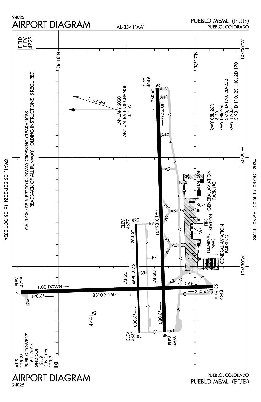
Pueblo Memorial
ICAO Identifier KPUB
Pueblo, CO
Pueblo Memorial
ICAO Identifier KPUB
AD 2.2 Aerodrome Geographical and Administrative Data
2.2.1 Reference Point: 38-17-23.811N / 104-29-52.901W
2.2.2 From City: 5 miles E of PUEBLO, CO
2.2.3 Elevation: 4729.3 ft
2.2.5 Magnetic Variation: 8E (2015)
2.2.6 Airport Contact: GREG PEDROZA
31201 BRYAN CIRCLE
PUEBLO, CO 81001 (719-553-2760)
2.2.7 Traffic: IFR/VFR
AD 2.3 Attendance Schedule
2.3.1 All Months, All Days, 0500-2200 Hours
AD 2.4 Handling Services and Facilities
2.4.1 Cargo Handling Facilities: NO
2.4.2 Fuel Types: 100LL A
2.4.5 Hangar Space: YES
2.4.6 Repair Facilities: MAJOR
AD 2.6 Rescue and Firefighting Services
2.6.1 Aerodrome Category: Class-I certified on 5/1/1973
2.6.2 Rescue and Firefighting Services: ARFF Index-A
AD 2.12 Runway Physical Characteristics
2.12.1 Designation: 08L
2.12.2 True Bearing: 88
2.12.3 True Dimensions: 4690 ft x 75 ft
2.12.4 PCN:
2.12.5 Coordinates: 38-17-24.3081N / 104-30-36.6451W
2.12.6 Threshold Elevation: 4681.2
2.12.6 Touchdown Zone Elevation: 4681.2
2.12.1 Designation: 26R
2.12.2 True Bearing: 268
2.12.3 True Dimensions: 4690 ft x 75 ft
2.12.4 PCN:
2.12.5 Coordinates: 38-17-25.7014N / 104-29-37.865W
2.12.6 Threshold Elevation: 4677
2.12.6 Touchdown Zone Elevation: 4678.1
2.12.1 Designation: 08R
2.12.2 True Bearing: 88
2.12.3 True Dimensions: 10498 ft x 150 ft
2.12.4 PCN:
2.12.5 Coordinates: 38-17-13.6348N / 104-30-36.2409W
2.12.6 Threshold Elevation: 4669.4
2.12.6 Touchdown Zone Elevation: 4671.4
2.12.1 Designation: 26L
2.12.2 True Bearing: 268
2.12.3 True Dimensions: 10498 ft x 150 ft
2.12.4 PCN:
2.12.5 Coordinates: 38-17-16.7526N / 104-28-24.6616W
2.12.6 Threshold Elevation: 4648.8
2.12.6 Touchdown Zone Elevation: 4658.9
2.12.1 Designation: 17
2.12.2 True Bearing: 178
2.12.3 True Dimensions: 8310 ft x 150 ft
2.12.4 PCN:
2.12.5 Coordinates: 38-18-15.0609N / 104-30-14.6942W
2.12.6 Threshold Elevation: 4729.3
2.12.6 Touchdown Zone Elevation: 4729.3
2.12.1 Designation: 35
2.12.2 True Bearing: 358
2.12.3 True Dimensions: 8310 ft x 150 ft
2.12.4 PCN:
2.12.5 Coordinates: 38-16-52.9717N / 104-30-11.6348W
2.12.6 Threshold Elevation: 4648.1
2.12.6 Touchdown Zone Elevation: 4676.9
AD 2.13 Declared Distances
2.13.1 Designation: 08L
2.13.2 Take-off Run Available: 4690
2.13.3 Take-off Distance Available: 4690
2.13.4 Accelerate-Stop Distance Available: 4690
2.13.5 Landing Distance Available: 4690
2.13.1 Designation: 26R
2.13.2 Take-off Run Available: 4690
2.13.3 Take-off Distance Available: 4690
2.13.4 Accelerate-Stop Distance Available: 4690
2.13.5 Landing Distance Available: 4690
2.13.1 Designation: 08R
2.13.2 Take-off Run Available: 10496
2.13.3 Take-off Distance Available: 10496
2.13.4 Accelerate-Stop Distance Available: 10496
2.13.5 Landing Distance Available: 10496
2.13.1 Designation: 26L
2.13.2 Take-off Run Available: 10496
2.13.3 Take-off Distance Available: 10496
2.13.4 Accelerate-Stop Distance Available: 10496
2.13.5 Landing Distance Available: 10496
2.13.1 Designation: 17
2.13.2 Take-off Run Available: 8308
2.13.3 Take-off Distance Available: 8308
2.13.4 Accelerate-Stop Distance Available: 8308
2.13.5 Landing Distance Available: 8308
2.13.1 Designation: 35
2.13.2 Take-off Run Available: 8308
2.13.3 Take-off Distance Available: 8308
2.13.4 Accelerate-Stop Distance Available: 8308
2.13.5 Landing Distance Available: 8308
AD 2.14 Approach and Runway Lighting
2.14.1 Designation: 08L
2.14.2 Approach Lighting System:
2.14.4 Visual Approach Slope Indicator System: P4L
2.14.1 Designation: 26R
2.14.2 Approach Lighting System:
2.14.4 Visual Approach Slope Indicator System: P4L
2.14.1 Designation: 08R
2.14.2 Approach Lighting System: MALSR
2.14.4 Visual Approach Slope Indicator System: P4L
2.14.1 Designation: 26L
2.14.2 Approach Lighting System:
2.14.4 Visual Approach Slope Indicator System: P4L
2.14.1 Designation: 17
2.14.2 Approach Lighting System:
2.14.4 Visual Approach Slope Indicator System: P4L
2.14.1 Designation: 35
2.14.2 Approach Lighting System:
2.14.4 Visual Approach Slope Indicator System: P4L
AD 2.18 Air Traffic Services Communication Facilities
2.18.1 Service Designation: ATIS
2.18.3 Channel: 125.25
2.18.5 Hours of Operation: 24
2.18.1 Service Designation: CD/P
2.18.3 Channel: 120.9
2.18.5 Hours of Operation: 0600-2200
2.18.1 Service Designation: EMERG
2.18.3 Channel: 121.5
2.18.5 Hours of Operation:
2.18.1 Service Designation: EMERG
2.18.3 Channel: 243
2.18.5 Hours of Operation:
2.18.1 Service Designation: GND/P
2.18.3 Channel: 121.9
2.18.5 Hours of Operation: 0600-2200
2.18.1 Service Designation: LCL/P
2.18.3 Channel: 119.1
2.18.5 Hours of Operation: 0600-2200
2.18.1 Service Designation: LCL/P
2.18.3 Channel: 257.8
2.18.5 Hours of Operation: 0600-2200
AD 2.19 Radio Navigation and Landing Aids
2.19.1 ILS Type: Glide Slop for runway 08R. Magnetic variation: 8E
2.19.2 ILS Identification: PUB
2.19.5 Coordinates: 38-17-18.9334N / 104-30-21.5794W
2.19.6 Site Elevation: 4672.8 ft
2.19.1 ILS Type: Localizer for runway 08R. Magnetic variation: 8E
2.19.2 ILS Identification: PUB
2.19.5 Coordinates: 38-17-17.2016N / 104-28-06.1097W
2.19.6 Site Elevation: 4653.1 ft
2.19.1 ILS Type: Glide Slop for runway 26L. Magnetic variation: 8E
2.19.2 ILS Identification: TFR
2.19.5 Coordinates: 38-17-21.3596N / 104-28-39.1966W
2.19.6 Site Elevation: 4649.4 ft
2.19.1 ILS Type: Localizer for runway 26L. Magnetic variation: 8E
2.19.2 ILS Identification: TFR
2.19.5 Coordinates: 38-17-13.2497N / 104-30-52.5582W
2.19.6 Site Elevation: 4668 ft
2.19.1 Navigation Aid Type VORTAC. Magnetic variation: 8E
2.19.2 Navigation Aid Identification: PUB
2.19.5 Coordinates: 38-17-39.3132N / 104-25-46.0107W
2.19.6 Site Elevation: 4755.5 ft
General Remarks:
HIGH VOLUME TRNG DA-20 ACFT SR-SS MON-FRI. OVERHEAD PATTERN DURG TRNG. EXTENSIVE USE OF TRNG AREA 12-28 DME N-SW OF ARPT 500 FT AGL-8500 FT MSL.
BE ALERT; INTENSIVE USAF STUDENT TRAINING IN VICINITY OF COLORADO SPRINGS & PUEBLO COLORADO.
CONDITIONS NOT MONITORED 2200L-0500L.
TWY A2 CLSD PERMLY/REMOVED.
SEE FLIP AP/1 SUPPLEMENTARY ARPT INFO.
RAPID RFL AVBL F/W, R/W DUR FBO HR 0700L-2200L. CTC FBO 719-948-1310 24 HR PN & FREQ 122.95 PRIOR TO LNDG. ADZ ATC FOR RAPID RFL OPS & PROCD TO WEST RAMP.
RAMP-TAXI LANE E EXTD 30 FT WIDE FM EAST RAMP TO TWY E7.
TWY A BTN TWY A2 AND A6 50 FT WID.
FOR CD CTC PUEBLO APCH AT 303-342-1916, WHEN APCH CLSD CTC DENVER ARTCC AT 303-651-4257.