Indiana
Indianapolis, Indiana
Indianapolis International
ICAO Identifier KIND
Indianapolis, IN
Indianapolis Intl
ICAO Identifier KIND
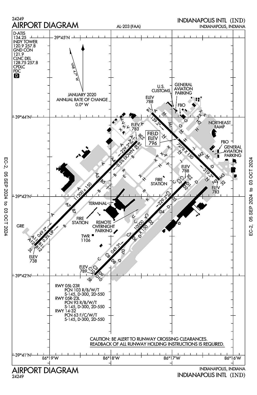
AD 2.2 Aerodrome Geographical and Administrative Data
2.2.1 Reference Point: 39-43-02.3N / 86-17-40.7W
2.2.2 From City: 7 miles SW of INDIANAPOLIS, IN
2.2.3 Elevation: 796.2 ft
2.2.5 Magnetic Variation: 5W (2015)
2.2.6 Airport Contact: MARIO RODRIGUEZ
7800 COL. H. WEIR COOK MEMORIAL DR.
INDIANAPOLIS, IN 46241 (317-487-9594)
2.2.7 Traffic: IFR/VFR
AD 2.3 Attendance Schedule
2.3.1 All Months, All Days, All Hours
AD 2.4 Handling Services and Facilities
2.4.1 Cargo Handling Facilities: YES
2.4.2 Fuel Types: 100LL A A1+
2.4.5 Hangar Space:
2.4.6 Repair Facilities: MAJOR
AD 2.6 Rescue and Firefighting Services
2.6.1 Aerodrome Category: Class-I certified on 5/1/1973
2.6.2 Rescue and Firefighting Services: ARFF Index-D
AD 2.12 Runway Physical Characteristics
2.12.1 Designation: 05L
2.12.2 True Bearing: 45
2.12.3 True Dimensions: 11200 ft x 150 ft
2.12.4 PCN: 103 R/B/W/T
2.12.5 Coordinates: 39-42-23.0337N / 86-19-14.9025W
2.12.6 Threshold Elevation: 738
2.12.6 Touchdown Zone Elevation: 747.3
2.12.1 Designation: 23R
2.12.2 True Bearing: 225
2.12.3 True Dimensions: 11200 ft x 150 ft
2.12.4 PCN: 103 R/B/W/T
2.12.5 Coordinates: 39-43-41.9101N / 86-17-34.3591W
2.12.6 Threshold Elevation: 782.9
2.12.6 Touchdown Zone Elevation: 782.9
2.12.1 Designation: 05R
2.12.2 True Bearing: 45
2.12.3 True Dimensions: 10000 ft x 150 ft
2.12.4 PCN: 93 R/B/W/T
2.12.5 Coordinates: 39-42-00.873N / 86-18-15.906W
2.12.6 Threshold Elevation: 788.8
2.12.6 Touchdown Zone Elevation: 790.7
2.12.1 Designation: 23L
2.12.2 True Bearing: 225
2.12.3 True Dimensions: 10000 ft x 150 ft
2.12.4 PCN: 93 R/B/W/T
2.12.5 Coordinates: 39-43-11.2875N / 86-16-46.1248W
2.12.6 Threshold Elevation: 787.6
2.12.6 Touchdown Zone Elevation: 790.1
2.12.1 Designation: 14
2.12.2 True Bearing: 135
2.12.3 True Dimensions: 7278 ft x 150 ft
2.12.4 PCN: 63 F/C/W/T
2.12.5 Coordinates: 39-44-03.2059N / 86-17-19.7638W
2.12.6 Threshold Elevation: 787.5
2.12.6 Touchdown Zone Elevation: 796.2
2.12.1 Designation: 32
2.12.2 True Bearing: 315
2.12.3 True Dimensions: 7278 ft x 150 ft
2.12.4 PCN: 63 F/C/W/T
2.12.5 Coordinates: 39-43-12.7458N / 86-16-13.3895W
2.12.6 Threshold Elevation: 782.6
2.12.6 Touchdown Zone Elevation: 792.9
AD 2.13 Declared Distances
2.13.1 Designation: 05L
2.13.2 Take-off Run Available: 11200
2.13.3 Take-off Distance Available: 11200
2.13.4 Accelerate-Stop Distance Available: 11200
2.13.5 Landing Distance Available: 11200
2.13.1 Designation: 23R
2.13.2 Take-off Run Available: 11200
2.13.3 Take-off Distance Available: 11200
2.13.4 Accelerate-Stop Distance Available: 11200
2.13.5 Landing Distance Available: 11200
2.13.1 Designation: 05R
2.13.2 Take-off Run Available: 10000
2.13.3 Take-off Distance Available: 10000
2.13.4 Accelerate-Stop Distance Available: 10000
2.13.5 Landing Distance Available: 10000
2.13.1 Designation: 23L
2.13.2 Take-off Run Available: 10000
2.13.3 Take-off Distance Available: 10000
2.13.4 Accelerate-Stop Distance Available: 10000
2.13.5 Landing Distance Available: 10000
2.13.1 Designation: 14
2.13.2 Take-off Run Available: 7278
2.13.3 Take-off Distance Available: 7278
2.13.4 Accelerate-Stop Distance Available: 7278
2.13.5 Landing Distance Available: 7278
2.13.1 Designation: 32
2.13.2 Take-off Run Available: 7278
2.13.3 Take-off Distance Available: 7278
2.13.4 Accelerate-Stop Distance Available: 7278
2.13.5 Landing Distance Available: 7278
AD 2.14 Approach and Runway Lighting
2.14.1 Designation: 05L
2.14.2 Approach Lighting System: ALSF2
2.14.4 Visual Approach Slope Indicator System: P4L
2.14.1 Designation: 23R
2.14.2 Approach Lighting System: MALSR
2.14.4 Visual Approach Slope Indicator System: P4L
2.14.1 Designation: 05R
2.14.2 Approach Lighting System: ALSF2
2.14.4 Visual Approach Slope Indicator System: P4L
2.14.1 Designation: 23L
2.14.2 Approach Lighting System: MALSR
2.14.4 Visual Approach Slope Indicator System: P4L
2.14.1 Designation: 14
2.14.2 Approach Lighting System: MALSR
2.14.4 Visual Approach Slope Indicator System: P4L
2.14.1 Designation: 32
2.14.2 Approach Lighting System: MALSR
2.14.4 Visual Approach Slope Indicator System: P4R
AD 2.18 Air Traffic Services Communication Facilities
2.18.1 Service Designation: APCH/P (WEST OF ACTIVE RWY)
2.18.3 Channel: 124.65
2.18.5 Hours of Operation: 24
2.18.1 Service Designation: APCH/P (EAST OF ACTIVE RWY)
2.18.3 Channel: 127.15
2.18.5 Hours of Operation: 24
2.18.1 Service Designation: APCH/P DEP/P
2.18.3 Channel: 317.8
2.18.5 Hours of Operation: 24
2.18.1 Service Designation: APCH/P IC
2.18.3 Channel: 128.175
2.18.5 Hours of Operation: 24
2.18.1 Service Designation: CD PRE TAXI CLNC
2.18.3 Channel: 128.75
2.18.5 Hours of Operation: 24
2.18.1 Service Designation: CD/P
2.18.3 Channel: 257.8
2.18.5 Hours of Operation: 24
2.18.1 Service Designation: CLANG STAR
2.18.3 Channel: 128.175
2.18.5 Hours of Operation: 24
2.18.1 Service Designation: CLANG STAR
2.18.3 Channel: 317.8
2.18.5 Hours of Operation: 24
2.18.1 Service Designation: CLASS C (WEST OF ACTIVE RWY)
2.18.3 Channel: 124.65
2.18.5 Hours of Operation: 24
2.18.1 Service Designation: CLASS C (EAST)
2.18.3 Channel: 124.95
2.18.5 Hours of Operation: 24
2.18.1 Service Designation: CLASS C (EAST OF ACTIVE RWY)
2.18.3 Channel: 127.15
2.18.5 Hours of Operation: 24
2.18.1 Service Designation: CLASS C
2.18.3 Channel: 317.8
2.18.5 Hours of Operation: 24
2.18.1 Service Designation: D-ATIS
2.18.3 Channel: 134.25
2.18.5 Hours of Operation: 24
2.18.1 Service Designation: DEP/P (WEST)
2.18.3 Channel: 119.05
2.18.5 Hours of Operation: 24
2.18.1 Service Designation: DEP/P (EAST)
2.18.3 Channel: 124.95
2.18.5 Hours of Operation: 24
2.18.1 Service Designation: EMERG
2.18.3 Channel: 121.5
2.18.5 Hours of Operation:
2.18.1 Service Designation: EMERG
2.18.3 Channel: 243
2.18.5 Hours of Operation:
2.18.1 Service Designation: GND/P
2.18.3 Channel: 121.9
2.18.5 Hours of Operation: 24
2.18.1 Service Designation: GND/S
2.18.3 Channel: 121.8
2.18.5 Hours of Operation: 24
2.18.1 Service Designation: LCL/P
2.18.3 Channel: 120.9
2.18.5 Hours of Operation: 24
2.18.1 Service Designation: LCL/P
2.18.3 Channel: 257.8
2.18.5 Hours of Operation: 24
2.18.1 Service Designation: RACYR STAR
2.18.3 Channel: 128.175
2.18.5 Hours of Operation: 24
2.18.1 Service Designation: RACYR STAR
2.18.3 Channel: 317.8
2.18.5 Hours of Operation: 24
AD 2.19 Radio Navigation and Landing Aids
2.19.1 ILS Type: DME for runway 05L. Magnetic variation: 5W
2.19.2 ILS Identification: IND
2.19.5 Coordinates: 39-43-51.3513N / 86-17-27.5671W
2.19.6 Site Elevation: 797.6 ft
2.19.1 ILS Type: Glide Slop for runway 05L. Magnetic variation: 5W
2.19.2 ILS Identification: IND
2.19.5 Coordinates: 39-42-32.7741N / 86-19-09.6768W
2.19.6 Site Elevation: 735.4 ft
2.19.1 ILS Type: Inner Marker for runway 05L. Magnetic variation: 5W
2.19.2 ILS Identification: IND
2.19.5 Coordinates: 39-42-15.7098N / 86-19-24.4367W
2.19.6 Site Elevation: 735.9 ft
2.19.1 ILS Type: Localizer for runway 05L. Magnetic variation: 5W
2.19.2 ILS Identification: IND
2.19.5 Coordinates: 39-43-49.0283N / 86-17-25.2797W
2.19.6 Site Elevation: 787.8 ft
2.19.1 ILS Type: DME for runway 23R. Magnetic variation: 5W
2.19.2 ILS Identification: UZK
2.19.5 Coordinates: 39-43-51.3513N / 86-17-27.5671W
2.19.6 Site Elevation: 797.6 ft
2.19.1 ILS Type: Glide Slop for runway 23R. Magnetic variation: 5W
2.19.2 ILS Identification: UZK
2.19.5 Coordinates: 39-43-36.5113N / 86-17-48.4342W
2.19.6 Site Elevation: 772.4 ft
2.19.1 ILS Type: Localizer for runway 23R. Magnetic variation: 5W
2.19.2 ILS Identification: UZK
2.19.5 Coordinates: 39-42-15.9186N / 86-19-23.9666W
2.19.6 Site Elevation: 736.6 ft
2.19.1 ILS Type: DME for runway 05R. Magnetic variation: 5W
2.19.2 ILS Identification: OQV
2.19.5 Coordinates: 39-43-20.1868N / 86-16-39.5353W
2.19.6 Site Elevation: 802 ft
2.19.1 ILS Type: Glide Slop for runway 05R. Magnetic variation: 5W
2.19.2 ILS Identification: OQV
2.19.5 Coordinates: 39-42-05.3627N / 86-18-02.9983W
2.19.6 Site Elevation: 788.5 ft
2.19.1 ILS Type: Inner Marker for runway 05R. Magnetic variation: 5W
2.19.2 ILS Identification: OQV
2.19.5 Coordinates: 39-41-52.07N / 86-18-27.12W
2.19.6 Site Elevation: 784.4 ft
2.19.1 ILS Type: Localizer for runway 05R. Magnetic variation: 5W
2.19.2 ILS Identification: OQV
2.19.5 Coordinates: 39-43-18.3778N / 86-16-37.0825W
2.19.6 Site Elevation: 795.5 ft
2.19.1 ILS Type: DME for runway 23L. Magnetic variation: 5W
2.19.2 ILS Identification: FVJ
2.19.5 Coordinates: 39-43-20.1868N / 86-16-39.5353W
2.19.6 Site Elevation: 802 ft
2.19.1 ILS Type: Glide Slop for runway 23L. Magnetic variation: 5W
2.19.2 ILS Identification: FVJ
2.19.5 Coordinates: 39-43-01.17N / 86-16-51.66W
2.19.6 Site Elevation: 782 ft
2.19.1 ILS Type: Localizer for runway 23L. Magnetic variation: 5W
2.19.2 ILS Identification: FVJ
2.19.5 Coordinates: 39-41-53.48N / 86-18-25.33W
2.19.6 Site Elevation: 787.3 ft
2.19.1 ILS Type: Glide Slop for runway 14. Magnetic variation: 5W
2.19.2 ILS Identification: BJP
2.19.5 Coordinates: 39-43-59.3065N / 86-17-07.3342W
2.19.6 Site Elevation: 790 ft
2.19.1 ILS Type: Localizer for runway 14. Magnetic variation: 5W
2.19.2 ILS Identification: BJP
2.19.5 Coordinates: 39-43-05.64N / 86-16-04.06W
2.19.6 Site Elevation: 768.5 ft
2.19.1 ILS Type: Glide Slop for runway 32. Magnetic variation: 5W
2.19.2 ILS Identification: COA
2.19.5 Coordinates: 39-43-16.2751N / 86-16-25.5096W
2.19.6 Site Elevation: 781.7 ft
2.19.1 ILS Type: Localizer for runway 32. Magnetic variation: 5W
2.19.2 ILS Identification: COA
2.19.5 Coordinates: 39-44-10.3487N / 86-17-29.1696W
2.19.6 Site Elevation: 782.3 ft
General Remarks:
TWY V IS NOT AVBL FOR ACR OPS.
TWY H RUNS CONTIGUOUS AT NORTHEAST RAMP.
LARGE FLOCKS OF BIRDS ON & INVOF ARPT.
NOISE ABATEMENT PROCEDURES IN EFFECT CTC ARPT MGR.
PRIM STUDENT TGL NOT PMTD.
BE ALERT TO CLOSE PROXIMITY OF RWY 14/32 TO NORTHEAST RAMP.