District of Columbia
Washington, District of Columbia
Washington Dulles International
ICAO Identifier KIAD
Washington, DC
Washington Dulles Intl
ICAO Identifier KIAD
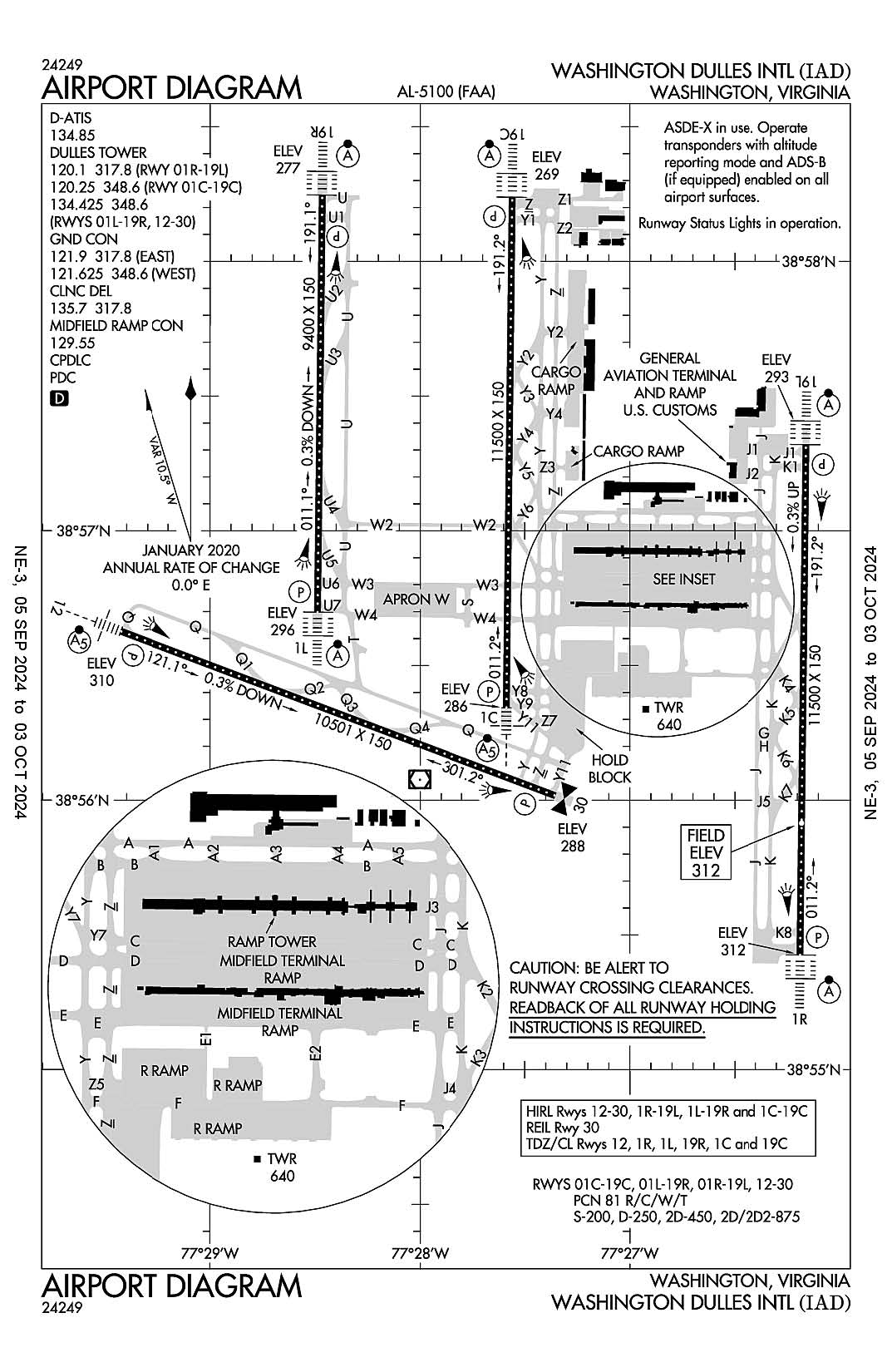
AD 2.2 Aerodrome Geographical and Administrative Data
2.2.1 Reference Point: 38-56-50.843N / 77-27-35.743W
2.2.2 From City: 20 miles W of WASHINGTON, VA
2.2.3 Elevation: 312.3 ft
2.2.5 Magnetic Variation: 10W (2000)
2.2.6 Airport Contact: RICHARD GOLINOWSKI
1 SAARINEN CIRCLE
DULLES, VA 20166 (703-572-2730)
2.2.7 Traffic: IFR/VFR
AD 2.3 Attendance Schedule
2.3.1 All Months, All Days, All Hours
AD 2.4 Handling Services and Facilities
2.4.1 Cargo Handling Facilities: YES
2.4.2 Fuel Types: 100LL A
2.4.5 Hangar Space: YES
2.4.6 Repair Facilities: MAJOR
AD 2.6 Rescue and Firefighting Services
2.6.1 Aerodrome Category: Class-I certified on 5/1/1973
2.6.2 Rescue and Firefighting Services: ARFF Index-E
AD 2.12 Runway Physical Characteristics
2.12.1 Designation: 19C
2.12.2 True Bearing: 181
2.12.3 True Dimensions: 11500 ft x 150 ft
2.12.4 PCN: 81 R/C/W/T
2.12.5 Coordinates: 38-58-14.3073N / 77-27-33.5451W
2.12.6 Threshold Elevation: 268.6
2.12.6 Touchdown Zone Elevation: 271.8
2.12.1 Designation: 01C
2.12.2 True Bearing: 1
2.12.3 True Dimensions: 11500 ft x 150 ft
2.12.4 PCN: 81 R/C/W/T
2.12.5 Coordinates: 38-56-20.6385N / 77-27-35.199W
2.12.6 Threshold Elevation: 286.1
2.12.6 Touchdown Zone Elevation: 286.1
2.12.1 Designation: 01L
2.12.2 True Bearing: 1
2.12.3 True Dimensions: 9400 ft x 150 ft
2.12.4 PCN: 81 R/C/W/T
2.12.5 Coordinates: 38-56-41.8795N / 77-28-29.3169W
2.12.6 Threshold Elevation: 296
2.12.6 Touchdown Zone Elevation: 296
2.12.1 Designation: 19R
2.12.2 True Bearing: 181
2.12.3 True Dimensions: 9400 ft x 150 ft
2.12.4 PCN: 81 R/C/W/T
2.12.5 Coordinates: 38-58-14.784N / 77-28-27.984W
2.12.6 Threshold Elevation: 277
2.12.6 Touchdown Zone Elevation: 278.3
2.12.1 Designation: 19L
2.12.2 True Bearing: 181
2.12.3 True Dimensions: 11500 ft x 150 ft
2.12.4 PCN: 81 R/C/W/T
2.12.5 Coordinates: 38-57-19.1867N / 77-26-09.5086W
2.12.6 Threshold Elevation: 293
2.12.6 Touchdown Zone Elevation: 302
2.12.1 Designation: 01R
2.12.2 True Bearing: 1
2.12.3 True Dimensions: 11500 ft x 150 ft
2.12.4 PCN: 81 R/C/W/T
2.12.5 Coordinates: 38-55-25.5244N / 77-26-11.2132W
2.12.6 Threshold Elevation: 311.7
2.12.6 Touchdown Zone Elevation: 312.3
2.12.1 Designation: 30
2.12.2 True Bearing: 291
2.12.3 True Dimensions: 10501 ft x 150 ft
2.12.4 PCN: 81 R/C/W/T
2.12.5 Coordinates: 38-56-00.9996N / 77-27-21.2257W
2.12.6 Threshold Elevation: 287.6
2.12.6 Touchdown Zone Elevation: 287.7
2.12.1 Designation: 12
2.12.2 True Bearing: 111
2.12.3 True Dimensions: 10501 ft x 150 ft
2.12.4 PCN: 81 R/C/W/T
2.12.5 Coordinates: 38-56-37.5897N / 77-29-25.5882W
2.12.6 Threshold Elevation: 309.9
2.12.6 Touchdown Zone Elevation: 309.9
AD 2.13 Declared Distances
2.13.1 Designation: 19C
2.13.2 Take-off Run Available: 11500
2.13.3 Take-off Distance Available: 11500
2.13.4 Accelerate-Stop Distance Available: 11500
2.13.5 Landing Distance Available: 11089
2.13.1 Designation: 01C
2.13.2 Take-off Run Available: 11500
2.13.3 Take-off Distance Available: 11500
2.13.4 Accelerate-Stop Distance Available: 11500
2.13.5 Landing Distance Available: 11500
2.13.1 Designation: 01L
2.13.2 Take-off Run Available: 9400
2.13.3 Take-off Distance Available: 9400
2.13.4 Accelerate-Stop Distance Available: 9400
2.13.5 Landing Distance Available: 9400
2.13.1 Designation: 19R
2.13.2 Take-off Run Available: 9400
2.13.3 Take-off Distance Available: 9400
2.13.4 Accelerate-Stop Distance Available: 9400
2.13.5 Landing Distance Available: 9400
2.13.1 Designation: 19L
2.13.2 Take-off Run Available: 11500
2.13.3 Take-off Distance Available: 11500
2.13.4 Accelerate-Stop Distance Available: 11500
2.13.5 Landing Distance Available: 11500
2.13.1 Designation: 01R
2.13.2 Take-off Run Available: 11500
2.13.3 Take-off Distance Available: 11500
2.13.4 Accelerate-Stop Distance Available: 11500
2.13.5 Landing Distance Available: 11500
2.13.1 Designation: 30
2.13.2 Take-off Run Available: 10501
2.13.3 Take-off Distance Available: 10501
2.13.4 Accelerate-Stop Distance Available: 10501
2.13.5 Landing Distance Available: 10501
2.13.1 Designation: 12
2.13.2 Take-off Run Available: 10501
2.13.3 Take-off Distance Available: 10501
2.13.4 Accelerate-Stop Distance Available: 10501
2.13.5 Landing Distance Available: 10501
AD 2.14 Approach and Runway Lighting
2.14.1 Designation: 19C
2.14.2 Approach Lighting System: ALSF2
2.14.4 Visual Approach Slope Indicator System: P4R
2.14.1 Designation: 01C
2.14.2 Approach Lighting System: MALSR
2.14.4 Visual Approach Slope Indicator System: P4L
2.14.1 Designation: 01L
2.14.2 Approach Lighting System: ALSF2
2.14.4 Visual Approach Slope Indicator System: P4L
2.14.1 Designation: 19R
2.14.2 Approach Lighting System: ALSF2
2.14.4 Visual Approach Slope Indicator System: P4L
2.14.1 Designation: 19L
2.14.2 Approach Lighting System: ALSF2
2.14.4 Visual Approach Slope Indicator System: P4L
2.14.1 Designation: 01R
2.14.2 Approach Lighting System: ALSF2
2.14.4 Visual Approach Slope Indicator System: P4R
2.14.1 Designation: 30
2.14.2 Approach Lighting System:
2.14.4 Visual Approach Slope Indicator System: P4L
2.14.1 Designation: 12
2.14.2 Approach Lighting System: MALSR
2.14.4 Visual Approach Slope Indicator System: P4R
AD 2.18 Air Traffic Services Communication Facilities
2.18.1 Service Designation: CD/P
2.18.3 Channel: 135.7
2.18.5 Hours of Operation: 24
2.18.1 Service Designation: CD/P
2.18.3 Channel: 317.8
2.18.5 Hours of Operation: 24
2.18.1 Service Designation: D-ATIS
2.18.3 Channel: 134.85
2.18.5 Hours of Operation: 24
2.18.1 Service Designation: EMERG
2.18.3 Channel: 121.5
2.18.5 Hours of Operation:
2.18.1 Service Designation: EMERG
2.18.3 Channel: 243
2.18.5 Hours of Operation:
2.18.1 Service Designation: GND/P (WEST)
2.18.3 Channel: 121.625
2.18.5 Hours of Operation: 24
2.18.1 Service Designation: GND/P (EAST)
2.18.3 Channel: 121.9
2.18.5 Hours of Operation: 24
2.18.1 Service Designation: GND/P (EAST)
2.18.3 Channel: 317.8
2.18.5 Hours of Operation: 24
2.18.1 Service Designation: GND/P (WEST)
2.18.3 Channel: 348.6
2.18.5 Hours of Operation: 24
2.18.1 Service Designation: LCL/P (RWY 01R/19L)
2.18.3 Channel: 120.1
2.18.5 Hours of Operation: 24
2.18.1 Service Designation: LCL/P (RWY 01C/19C)
2.18.3 Channel: 120.25
2.18.5 Hours of Operation: 24
2.18.1 Service Designation: LCL/P (RWY 01L/19R, RWY 12/30)
2.18.3 Channel: 134.425
2.18.5 Hours of Operation: 24
2.18.1 Service Designation: LCL/P (RWY 01R/19L)
2.18.3 Channel: 317.8
2.18.5 Hours of Operation: 24
2.18.1 Service Designation: LCL/P (RWY 01C/19C)
2.18.3 Channel: 348.6
2.18.5 Hours of Operation: 24
2.18.1 Service Designation: LCL/P (RWY 01L/19R, RWY 12/30)
2.18.3 Channel: 348.6
2.18.5 Hours of Operation: 24
2.18.1 Service Designation: RAMP CTL (MIDFLD)
2.18.3 Channel: 129.55
2.18.5 Hours of Operation:
AD 2.19 Radio Navigation and Landing Aids
2.19.1 ILS Type: Glide Slop for runway 01C. Magnetic variation: 10W
2.19.2 ILS Identification: OSZ
2.19.5 Coordinates: 38-56-31.0626N / 77-27-40.739W
2.19.6 Site Elevation: 281.7 ft
2.19.1 ILS Type: Localizer for runway 01C. Magnetic variation: 10W
2.19.2 ILS Identification: OSZ
2.19.5 Coordinates: 38-58-24.6804N / 77-27-33.3938W
2.19.6 Site Elevation: 263.3 ft
2.19.1 ILS Type: Glide Slop for runway 19C. Magnetic variation: 10W
2.19.2 ILS Identification: DLX
2.19.5 Coordinates: 38-58-04.1642N / 77-27-37.9988W
2.19.6 Site Elevation: 264.9 ft
2.19.1 ILS Type: Inner Marker for runway 19C. Magnetic variation: 10W
2.19.2 ILS Identification: DLX
2.19.5 Coordinates: 38-58-22.945N / 77-27-33.4229W
2.19.6 Site Elevation: 263.5 ft
2.19.1 ILS Type: Localizer for runway 19C. Magnetic variation: 10W
2.19.2 ILS Identification: DLX
2.19.5 Coordinates: 38-56-14.5833N / 77-27-35.2871W
2.19.6 Site Elevation: 283.8 ft
2.19.1 ILS Type: DME for runway 01L. Magnetic variation: 10W
2.19.2 ILS Identification: OIU
2.19.5 Coordinates: 38-58-25.077N / 77-28-31.1445W
2.19.6 Site Elevation: 288.2 ft
2.19.1 ILS Type: Glide Slop for runway 01L. Magnetic variation: 10W
2.19.2 ILS Identification: OIU
2.19.5 Coordinates: 38-56-52.8758N / 77-28-34.3489W
2.19.6 Site Elevation: 288.1 ft
2.19.1 ILS Type: Inner Marker for runway 01L. Magnetic variation: 10W
2.19.2 ILS Identification: OIU
2.19.5 Coordinates: 38-56-33.3882N / 77-28-29.4318W
2.19.6 Site Elevation: 298.4 ft
2.19.1 ILS Type: Localizer for runway 01L. Magnetic variation: 10W
2.19.2 ILS Identification: OIU
2.19.5 Coordinates: 38-58-24.7952N / 77-28-27.8419W
2.19.6 Site Elevation: 276.9 ft
2.19.1 ILS Type: DME for runway 19R. Magnetic variation: 10W
2.19.2 ILS Identification: ISU
2.19.5 Coordinates: 38-58-25.077N / 77-28-31.1445W
2.19.6 Site Elevation: 288.2 ft
2.19.1 ILS Type: Glide Slop for runway 19R. Magnetic variation: 10W
2.19.2 ILS Identification: ISU
2.19.5 Coordinates: 38-58-04.4532N / 77-28-33.3236W
2.19.6 Site Elevation: 272 ft
2.19.1 ILS Type: Inner Marker for runway 19R. Magnetic variation: 10W
2.19.2 ILS Identification: ISU
2.19.5 Coordinates: 38-58-23.5162N / 77-28-27.8521W
2.19.6 Site Elevation: 275 ft
2.19.1 ILS Type: Localizer for runway 19R. Magnetic variation: 10W
2.19.2 ILS Identification: ISU
2.19.5 Coordinates: 38-56-31.869N / 77-28-29.461W
2.19.6 Site Elevation: 298.3 ft
2.19.1 ILS Type: DME for runway 01R. Magnetic variation: 10W
2.19.2 ILS Identification: IAD
2.19.5 Coordinates: 38-55-11.037N / 77-26-08.2071W
2.19.6 Site Elevation: 326.3 ft
2.19.1 ILS Type: Glide Slop for runway 01R. Magnetic variation: 10W
2.19.2 ILS Identification: IAD
2.19.5 Coordinates: 38-55-35.8487N / 77-26-04.7355W
2.19.6 Site Elevation: 306.4 ft
2.19.1 ILS Type: Localizer for runway 01R. Magnetic variation: 10W
2.19.2 ILS Identification: IAD
2.19.5 Coordinates: 38-57-30.8651N / 77-26-09.3346W
2.19.6 Site Elevation: 301.5 ft
2.19.1 ILS Type: DME for runway 19L. Magnetic variation: 10W
2.19.2 ILS Identification: SGC
2.19.5 Coordinates: 38-55-11.037N / 77-26-08.2071W
2.19.6 Site Elevation: 326.3 ft
2.19.1 ILS Type: Glide Slop for runway 19L. Magnetic variation: 10W
2.19.2 ILS Identification: SGC
2.19.5 Coordinates: 38-57-09.2652N / 77-26-04.5983W
2.19.6 Site Elevation: 290.9 ft
2.19.1 ILS Type: Localizer for runway 19L. Magnetic variation: 10W
2.19.2 ILS Identification: SGC
2.19.5 Coordinates: 38-55-11.8054N / 77-26-11.4157W
2.19.6 Site Elevation: 315.1 ft
2.19.1 ILS Type: Glide Slop for runway 12. Magnetic variation: 10W
2.19.2 ILS Identification: AJU
2.19.5 Coordinates: 38-56-30.4069N / 77-29-15.5183W
2.19.6 Site Elevation: 303.4 ft
2.19.1 ILS Type: Localizer for runway 12. Magnetic variation: 10W
2.19.2 ILS Identification: AJU
2.19.5 Coordinates: 38-55-57.2399N / 77-27-08.4716W
2.19.6 Site Elevation: 281 ft
General Remarks:
TAXILANE 'C' ACTIVE; PUSHBACK CLNCS ON NORTH SIDE OF MIDFIELD TERMINAL ARE ONTO TAXILANE 'D' ONLY UNLESS OTHERWISE AUTH.
RWY STATUS LGTS ARE IN OPN.
ENGINE RUN-UPS BTW 2200L & 0700L REQUIRE PRIOR APPROVAL FM ARPT OPS.
LARGE FLOCKS OF BIRDS ON & INVOF ARPT/DEER INVOF ARPT.
B747-8 RESTRICTED TO MAXIMUM TAXI SPEED 17 KTS (20 MPH) ON TWY J.
RUNUP BLX FOR RWY 30 DSGND AS NON-MOVEMENT AREA.
RWY 30 DEPARTURES USE UPPER ANTENNA FOR ATC COMMUNICATIONS.
ACR PUSH BACKS & PWR FM ALL APRON PSNS REQUIRE CLNC FM MWAA RAMP TWR.
ALL AIRCRAFT WITH WINGSPAN EXCEEDING 118 FT ARE RESTRICTED FROM USING TAXILANE A BTN A1 & A5.
ALL 180 DEG TURNS OUT OF APRON POSITIONS SHALL BE MADE USING MINIMUM POWER.
TWY E1 RESTRICTED TO ACFT WITH A WINGSPAN LESS THAN 79 FT.
FLIGHT TRAINING BETWEEN 2200-0700 IS PROHIBITED.
DURING PERIODS OF ACFT SATURATION LONG TERM PARKING MAY NOT BE AVAILABLE. SERVICES FOR FUEL AND GO ONLY WILL BE AVAILABLE.
ITNRNT ACFT CTC FBO ON 122.95 OR 129.77 FOR SVCS.
LDG FEE. FLIGHT NOTIFICATION SERVICE (ADCUS) AVBL. NOTE: SEE SPECIAL NOTICES --CONTINUOUS POWER FACILITIES.