American Samoa
Pago Pago, American Samoa
Pago Pago/International
ICAO Identifier NSTU
Pago Pago, AS
Pago Pago Intl
ICAO Identifier NSTU
AD 2.2 Aerodrome Geographical and Administrative Data
2.2.1 Reference Point: 14-19-53.984S / 170-42-41.411W
2.2.2 From City: 3 miles SW of PAGO PAGO, AS
2.2.3 Elevation: 31.2 ft
2.2.5 Magnetic Variation: 12E (1990)
2.2.6 Airport Contact: TAVITA S FUIMAONO
1539 AIRPORT WAY P.O. BOX 1539
PAGO PAGO, AS 96799 (684-733-3154)
2.2.7 Traffic: IFR/VFR
AD 2.3 Attendance Schedule
2.3.1 All Months, All Days, All Hours
AD 2.4 Handling Services and Facilities
2.4.1 Cargo Handling Facilities: YES
2.4.2 Fuel Types: 100 A1+
2.4.5 Hangar Space:
2.4.6 Repair Facilities: NONE
AD 2.6 Rescue and Firefighting Services
2.6.1 Aerodrome Category: Class-I certified on 5/1/1973
2.6.2 Rescue and Firefighting Services: ARFF Index-C
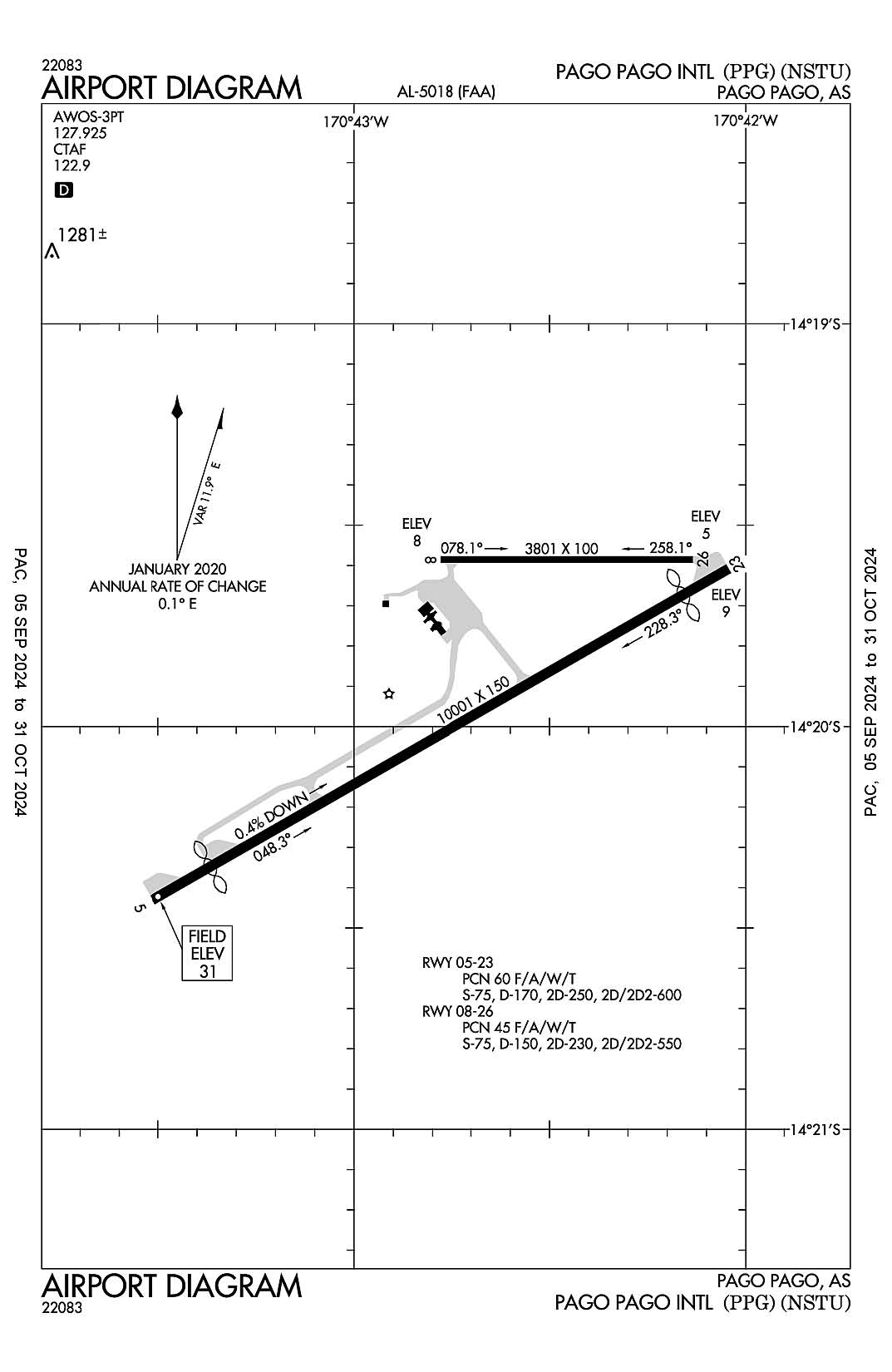
AD 2.12 Runway Physical Characteristics
2.12.1 Designation: 05
2.12.2 True Bearing: 60
2.12.3 True Dimensions: 10001 ft x 150 ft
2.12.4 PCN: 60 F/A/W/T
2.12.5 Coordinates: 14-20-25.8311S / 170-43-30.8448W
2.12.6 Threshold Elevation: 31.2
2.12.6 Touchdown Zone Elevation: 29.3
2.12.1 Designation: 23
2.12.2 True Bearing: 240
2.12.3 True Dimensions: 10001 ft x 150 ft
2.12.4 PCN: 60 F/A/W/T
2.12.5 Coordinates: 14-19-36.4755S / 170-42-02.6116W
2.12.6 Threshold Elevation: 8.7
2.12.6 Touchdown Zone Elevation: 8.7
2.12.1 Designation: 08
2.12.2 True Bearing: 90
2.12.3 True Dimensions: 3801 ft x 100 ft
2.12.4 PCN: 45 F/A/W/T
2.12.5 Coordinates: 14-19-35.126S / 170-42-46.7563W
2.12.6 Threshold Elevation: 8.1
2.12.6 Touchdown Zone Elevation: 8.1
2.12.1 Designation: 26
2.12.2 True Bearing: 270
2.12.3 True Dimensions: 3801 ft x 100 ft
2.12.4 PCN: 45 F/A/W/T
2.12.5 Coordinates: 14-19-35.1106S / 170-42-08.096W
2.12.6 Threshold Elevation: 4.8
2.12.6 Touchdown Zone Elevation: 5.7
AD 2.13 Declared Distances
2.13.1 Designation: 05
2.13.2 Take-off Run Available: 9200
2.13.3 Take-off Distance Available: 10000
2.13.4 Accelerate-Stop Distance Available: 9200
2.13.5 Landing Distance Available: 8200
2.13.1 Designation: 23
2.13.2 Take-off Run Available: 10000
2.13.3 Take-off Distance Available: 10000
2.13.4 Accelerate-Stop Distance Available: 10000
2.13.5 Landing Distance Available: 9200
2.13.1 Designation: 08
2.13.2 Take-off Run Available:
2.13.3 Take-off Distance Available:
2.13.4 Accelerate-Stop Distance Available:
2.13.5 Landing Distance Available:
2.13.1 Designation: 26
2.13.2 Take-off Run Available:
2.13.3 Take-off Distance Available:
2.13.4 Accelerate-Stop Distance Available:
2.13.5 Landing Distance Available:
AD 2.14 Approach and Runway Lighting
2.14.1 Designation: 05
2.14.2 Approach Lighting System: MALSR
2.14.4 Visual Approach Slope Indicator System: P4L
2.14.1 Designation: 23
2.14.2 Approach Lighting System:
2.14.4 Visual Approach Slope Indicator System: P4L
2.14.1 Designation: 08
2.14.2 Approach Lighting System:
2.14.4 Visual Approach Slope Indicator System:
2.14.1 Designation: 26
2.14.2 Approach Lighting System:
2.14.4 Visual Approach Slope Indicator System:
AD 2.18 Air Traffic Services Communication Facilities
AD 2.19 Radio Navigation and Landing Aids
2.19.1 ILS Type: DME for runway 05. Magnetic variation: 12E
2.19.2 ILS Identification: TUT
2.19.5 Coordinates: 14-19-37.6403S / 170-42-14.7077W
2.19.6 Site Elevation: 19.1 ft
2.19.1 ILS Type: Glide Slop for runway 05. Magnetic variation: 12E
2.19.2 ILS Identification: TUT
2.19.5 Coordinates: 14-20-13.069S / 170-43-15.1842W
2.19.6 Site Elevation: 24.5 ft
2.19.1 ILS Type: Localizer for runway 05. Magnetic variation: 12E
2.19.2 ILS Identification: TUT
2.19.5 Coordinates: 14-19-38.7728S / 170-42-12.8837W
2.19.6 Site Elevation: 5.1 ft
General Remarks:
OLOTELE MT 1617 FT MSL 3.5 MILES WEST OF THLD RY 08.
ALL ACFT TRANSITING PAGO PAGO (EXCP COMMERCIAL CARRIERS) MUST MAKE FUEL ARRANGEMENTS WITH PPG AT 684-733-3158.
< ALL FLTS (EXCP SKED) PRIOR PMSN FROM AMGR WITH 24 HRS PRIOR NOTICE.
FOR NOTAM CONTACT NEW ZEALAND (643) 358-1688FSS: NEW ZEALAND
SEA SPRAY FM SURF & BLOW HOLES MAY DRIFT ACRS RWY 05/23 UNDER ROUGH SEA CONDS.
PERMLY LGTD & MKD 226' TWR ATOP MT ALAVA 4.3SM NNE ARPT.