Massachusetts
Boston, Massachusetts
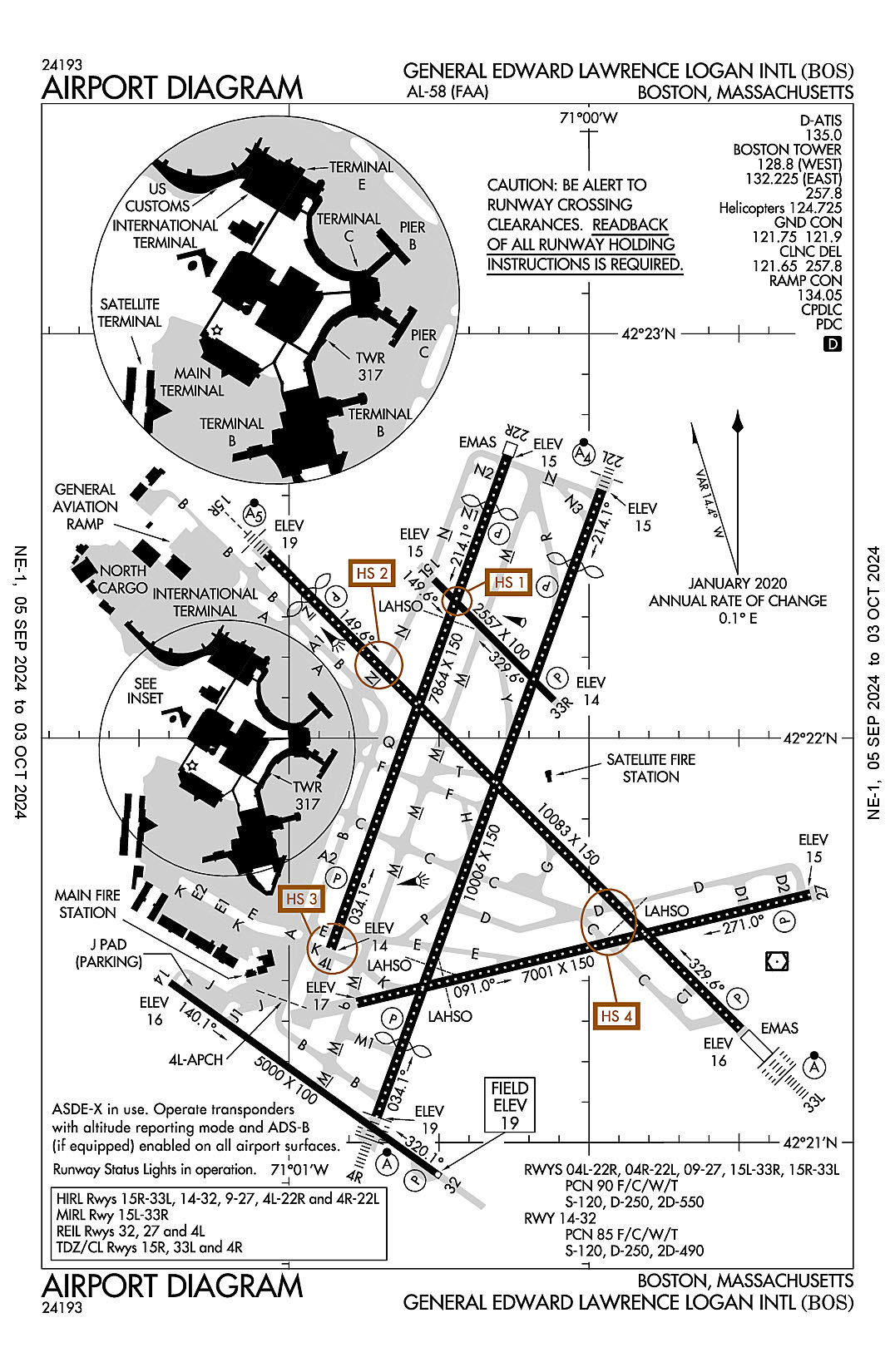
General Edward Lawrence Logan International
ICAO Identifier KBOS
Boston, MA
General Edward Lawrence Logan Intl
ICAO Identifier KBOS
AD 2.2 Aerodrome Geographical and Administrative Data
2.2.1 Reference Point: 42-21-46.6N / 71-00-23W
2.2.2 From City: 1 miles E of BOSTON, MA
2.2.3 Elevation: 19.1 ft
2.2.5 Magnetic Variation: 15W (2020)
2.2.6 Airport Contact: EDWARD FRENI
LOGAN INTERNATIONAL AIRPORT
EAST BOSTON, MA 2128 (617-567-5400)
2.2.7 Traffic: IFR/VFR
AD 2.3 Attendance Schedule
2.3.1 All Months, All Days, All Hours
AD 2.4 Handling Services and Facilities
2.4.1 Cargo Handling Facilities: YES
2.4.2 Fuel Types: 100LL A
2.4.5 Hangar Space:
2.4.6 Repair Facilities: MAJOR
AD 2.6 Rescue and Firefighting Services
2.6.1 Aerodrome Category: Class-I certified on 9/1/1972
2.6.2 Rescue and Firefighting Services: ARFF Index-E
AD 2.12 Runway Physical Characteristics
2.12.1 Designation: 04L
2.12.2 True Bearing: 20
2.12.3 True Dimensions: 7864 ft x 150 ft
2.12.4 PCN: 90 F/C/W/T
2.12.5 Coordinates: 42-21-28.7577N / 71-00-51.6187W
2.12.6 Threshold Elevation: 13.9
2.12.6 Touchdown Zone Elevation: 13.9
2.12.1 Designation: 22R
2.12.2 True Bearing: 200
2.12.3 True Dimensions: 7864 ft x 150 ft
2.12.4 PCN: 90 F/C/W/T
2.12.5 Coordinates: 42-22-41.8759N / 71-00-16.2499W
2.12.6 Threshold Elevation: 14.9
2.12.6 Touchdown Zone Elevation: 15.2
2.12.1 Designation: 04R
2.12.2 True Bearing: 20
2.12.3 True Dimensions: 10006 ft x 150 ft
2.12.4 PCN: 90 F/C/W/T
2.12.5 Coordinates: 42-21-03.8094N / 71-00-42.458W
2.12.6 Threshold Elevation: 18.8
2.12.6 Touchdown Zone Elevation: 17.6
2.12.1 Designation: 22L
2.12.2 True Bearing: 200
2.12.3 True Dimensions: 10006 ft x 150 ft
2.12.4 PCN: 90 F/C/W/T
2.12.5 Coordinates: 42-22-36.8399N / 70-59-57.4473W
2.12.6 Threshold Elevation: 14.5
2.12.6 Touchdown Zone Elevation: 15.6
2.12.1 Designation: 09
2.12.2 True Bearing: 77
2.12.3 True Dimensions: 7001 ft x 150 ft
2.12.4 PCN: 90 F/C/W/T
2.12.5 Coordinates: 42-21-20.715N / 71-00-46.4187W
2.12.6 Threshold Elevation: 16.7
2.12.6 Touchdown Zone Elevation: 16.8
2.12.1 Designation: 27
2.12.2 True Bearing: 257
2.12.3 True Dimensions: 7001 ft x 150 ft
2.12.4 PCN: 90 F/C/W/T
2.12.5 Coordinates: 42-21-36.7767N / 70-59-15.7276W
2.12.6 Threshold Elevation: 14.8
2.12.6 Touchdown Zone Elevation: 17.2
2.12.1 Designation: 32
2.12.2 True Bearing: 305
2.12.3 True Dimensions: 5000 ft x 100 ft
2.12.4 PCN: 85 F/C/W/T
2.12.5 Coordinates: 42-20-54.9565N / 71-00-29.6841W
2.12.6 Threshold Elevation: 19.1
2.12.6 Touchdown Zone Elevation: 19.1
2.12.1 Designation: 14
2.12.2 True Bearing: 125
2.12.3 True Dimensions: 5000 ft x 100 ft
2.12.4 PCN: 85 F/C/W/T
2.12.5 Coordinates: 42-21-23.7521N / 71-01-23.7886W
2.12.6 Threshold Elevation: 16
2.12.6 Touchdown Zone Elevation: 19.1
2.12.1 Designation: 15L
2.12.2 True Bearing: 135
2.12.3 True Dimensions: 2557 ft x 100 ft
2.12.4 PCN: 90 F/C/W/T
2.12.5 Coordinates: 42-22-23.5008N / 71-00-31.0047W
2.12.6 Threshold Elevation: 14.8
2.12.6 Touchdown Zone Elevation: 15.8
2.12.1 Designation: 33R
2.12.2 True Bearing: 315
2.12.3 True Dimensions: 2557 ft x 100 ft
2.12.4 PCN: 90 F/C/W/T
2.12.5 Coordinates: 42-22-05.5791N / 71-00-07.0008W
2.12.6 Threshold Elevation: 14
2.12.6 Touchdown Zone Elevation: 15.8
2.12.1 Designation: 15R
2.12.2 True Bearing: 135
2.12.3 True Dimensions: 10083 ft x 150 ft
2.12.4 PCN: 90 F/C/W/T
2.12.5 Coordinates: 42-22-27.3749N / 71-01-04.4117W
2.12.6 Threshold Elevation: 18.9
2.12.6 Touchdown Zone Elevation: 17
2.12.1 Designation: 33L
2.12.2 True Bearing: 315
2.12.3 True Dimensions: 10083 ft x 150 ft
2.12.4 PCN: 90 F/C/W/T
2.12.5 Coordinates: 42-21-16.7428N / 70-59-29.7098W
2.12.6 Threshold Elevation: 15.7
2.12.6 Touchdown Zone Elevation: 16.2
AD 2.13 Declared Distances
2.13.1 Designation: 04L
2.13.2 Take-off Run Available: 7864
2.13.3 Take-off Distance Available: 7864
2.13.4 Accelerate-Stop Distance Available: 7864
2.13.5 Landing Distance Available: 7864
2.13.1 Designation: 22R
2.13.2 Take-off Run Available: 7864
2.13.3 Take-off Distance Available: 7864
2.13.4 Accelerate-Stop Distance Available: 7864
2.13.5 Landing Distance Available: 7046
2.13.1 Designation: 04R
2.13.2 Take-off Run Available: 10006
2.13.3 Take-off Distance Available: 10006
2.13.4 Accelerate-Stop Distance Available: 10006
2.13.5 Landing Distance Available: 8851
2.13.1 Designation: 22L
2.13.2 Take-off Run Available: 10006
2.13.3 Take-off Distance Available: 10006
2.13.4 Accelerate-Stop Distance Available: 10006
2.13.5 Landing Distance Available: 8806
2.13.1 Designation: 09
2.13.2 Take-off Run Available: 7001
2.13.3 Take-off Distance Available: 7001
2.13.4 Accelerate-Stop Distance Available: 7001
2.13.5 Landing Distance Available: 7001
2.13.1 Designation: 27
2.13.2 Take-off Run Available: 7001
2.13.3 Take-off Distance Available: 7001
2.13.4 Accelerate-Stop Distance Available: 7001
2.13.5 Landing Distance Available: 7001
2.13.1 Designation: 32
2.13.2 Take-off Run Available: 5000
2.13.3 Take-off Distance Available: 5000
2.13.4 Accelerate-Stop Distance Available: 5000
2.13.5 Landing Distance Available: 5000
2.13.1 Designation: 14
2.13.2 Take-off Run Available: 5000
2.13.3 Take-off Distance Available: 5000
2.13.4 Accelerate-Stop Distance Available: 5000
2.13.5 Landing Distance Available: 5000
2.13.1 Designation: 15L
2.13.2 Take-off Run Available: 2557
2.13.3 Take-off Distance Available: 2557
2.13.4 Accelerate-Stop Distance Available: 2557
2.13.5 Landing Distance Available: 2557
2.13.1 Designation: 33R
2.13.2 Take-off Run Available: 2557
2.13.3 Take-off Distance Available: 2557
2.13.4 Accelerate-Stop Distance Available: 2557
2.13.5 Landing Distance Available: 2557
2.13.1 Designation: 15R
2.13.2 Take-off Run Available: 10083
2.13.3 Take-off Distance Available: 10083
2.13.4 Accelerate-Stop Distance Available: 10083
2.13.5 Landing Distance Available: 9202
2.13.1 Designation: 33L
2.13.2 Take-off Run Available: 10083
2.13.3 Take-off Distance Available: 10083
2.13.4 Accelerate-Stop Distance Available: 10083
2.13.5 Landing Distance Available: 10083
AD 2.14 Approach and Runway Lighting
2.14.1 Designation: 04L
2.14.2 Approach Lighting System:
2.14.4 Visual Approach Slope Indicator System: P4L
2.14.1 Designation: 22R
2.14.2 Approach Lighting System:
2.14.4 Visual Approach Slope Indicator System: P4L
2.14.1 Designation: 04R
2.14.2 Approach Lighting System: ALSF2
2.14.4 Visual Approach Slope Indicator System: P4L
2.14.1 Designation: 22L
2.14.2 Approach Lighting System: MALSF
2.14.4 Visual Approach Slope Indicator System: P4R
2.14.1 Designation: 09
2.14.2 Approach Lighting System:
2.14.4 Visual Approach Slope Indicator System:
2.14.1 Designation: 27
2.14.2 Approach Lighting System:
2.14.4 Visual Approach Slope Indicator System: P4L
2.14.1 Designation: 32
2.14.2 Approach Lighting System:
2.14.4 Visual Approach Slope Indicator System: P4L
2.14.1 Designation: 14
2.14.2 Approach Lighting System:
2.14.4 Visual Approach Slope Indicator System:
2.14.1 Designation: 15L
2.14.2 Approach Lighting System:
2.14.4 Visual Approach Slope Indicator System:
2.14.1 Designation: 33R
2.14.2 Approach Lighting System:
2.14.4 Visual Approach Slope Indicator System: P4R
2.14.1 Designation: 15R
2.14.2 Approach Lighting System: MALSR
2.14.4 Visual Approach Slope Indicator System: P4L
2.14.1 Designation: 33L
2.14.2 Approach Lighting System: ALSF2
2.14.4 Visual Approach Slope Indicator System: P4R
AD 2.18 Air Traffic Services Communication Facilities
2.18.1 Service Designation: CD PRE TAXI CLNC
2.18.3 Channel: 121.65
2.18.5 Hours of Operation: 24
2.18.1 Service Designation: CD/P
2.18.3 Channel: 257.8
2.18.5 Hours of Operation: 24
2.18.1 Service Designation: D-ATIS (ARR)
2.18.3 Channel: 135
2.18.5 Hours of Operation: 24
2.18.1 Service Designation: D-ATIS (DEP)
2.18.3 Channel: 135
2.18.5 Hours of Operation: 24
2.18.1 Service Designation: EMERG
2.18.3 Channel: 121.5
2.18.5 Hours of Operation:
2.18.1 Service Designation: EMERG
2.18.3 Channel: 243
2.18.5 Hours of Operation:
2.18.1 Service Designation: GND/P
2.18.3 Channel: 121.75
2.18.5 Hours of Operation: 24
2.18.1 Service Designation: GND/P
2.18.3 Channel: 121.9
2.18.5 Hours of Operation: 24
2.18.1 Service Designation: LCL/P (HELICOPTERS)
2.18.3 Channel: 124.725
2.18.5 Hours of Operation: 24
2.18.1 Service Designation: LCL/P (WEST)
2.18.3 Channel: 128.8
2.18.5 Hours of Operation: 24
2.18.1 Service Designation: LCL/P (EAST)
2.18.3 Channel: 132.225
2.18.5 Hours of Operation: 24
2.18.1 Service Designation: LCL/P
2.18.3 Channel: 257.8
2.18.5 Hours of Operation: 24
2.18.1 Service Designation: RAMP CTL
2.18.3 Channel: 134.05
2.18.5 Hours of Operation:
AD 2.19 Radio Navigation and Landing Aids
2.19.1 ILS Type: DME for runway 04R. Magnetic variation: 15W
2.19.2 ILS Identification: BOS
2.19.5 Coordinates: 42-22-57.4695N / 70-59-50.8873W
2.19.6 Site Elevation: 34.5 ft
2.19.1 ILS Type: Glide Slop for runway 04R. Magnetic variation: 15W
2.19.2 ILS Identification: BOS
2.19.5 Coordinates: 42-21-21.8231N / 71-00-24.5483W
2.19.6 Site Elevation: 10.1 ft
2.19.1 ILS Type: Localizer for runway 04R. Magnetic variation: 15W
2.19.2 ILS Identification: BOS
2.19.5 Coordinates: 42-22-55.9736N / 70-59-48.1884W
2.19.6 Site Elevation: 17.6 ft
2.19.1 ILS Type: DME for runway 22L. Magnetic variation: 15W
2.19.2 ILS Identification: LQN
2.19.5 Coordinates: 42-22-57.4695N / 70-59-50.8873W
2.19.6 Site Elevation: 34.5 ft
2.19.1 ILS Type: Glide Slop for runway 22L. Magnetic variation: 15W
2.19.2 ILS Identification: LQN
2.19.5 Coordinates: 42-22-17.0026N / 71-00-11.9878W
2.19.6 Site Elevation: 11.1 ft
2.19.1 ILS Type: Localizer for runway 22L. Magnetic variation: 15W
2.19.2 ILS Identification: LQN
2.19.5 Coordinates: 42-21-00.0409N / 71-00-44.2844W
2.19.6 Site Elevation: 14.6 ft
2.19.1 ILS Type: DME for runway 27. Magnetic variation: 15W
2.19.2 ILS Identification: DGU
2.19.5 Coordinates: 42-21-15.6955N / 71-00-55.7791W
2.19.6 Site Elevation: 30.5 ft
2.19.1 ILS Type: Glide Slop for runway 27. Magnetic variation: 15W
2.19.2 ILS Identification: DGU
2.19.5 Coordinates: 42-21-31.2953N / 70-59-28.3545W
2.19.6 Site Elevation: 12.3 ft
2.19.1 ILS Type: Localizer for runway 27. Magnetic variation: 15W
2.19.2 ILS Identification: DGU
2.19.5 Coordinates: 42-21-18.4751N / 71-00-59.0489W
2.19.6 Site Elevation: 16.5 ft
2.19.1 ILS Type: DME for runway 15R. Magnetic variation: 15W
2.19.2 ILS Identification: MDC
2.19.5 Coordinates: 42-21-26.5111N / 70-59-35.0574W
2.19.6 Site Elevation: 26.4 ft
2.19.1 ILS Type: Glide Slop for runway 15R. Magnetic variation: 15W
2.19.2 ILS Identification: MDC
2.19.5 Coordinates: 42-22-14.6947N / 71-00-42.4209W
2.19.6 Site Elevation: 11.2 ft
2.19.1 ILS Type: Localizer for runway 15R. Magnetic variation: 15W
2.19.2 ILS Identification: MDC
2.19.5 Coordinates: 42-21-26.3592N / 70-59-37.052W
2.19.6 Site Elevation: 11.1 ft
2.19.1 ILS Type: DME for runway 33L. Magnetic variation: 15W
2.19.2 ILS Identification: LIP
2.19.5 Coordinates: 42-21-26.5111N / 70-59-35.0574W
2.19.6 Site Elevation: 26.4 ft
2.19.1 ILS Type: Glide Slop for runway 33L. Magnetic variation: 15W
2.19.2 ILS Identification: LIP
2.19.5 Coordinates: 42-21-26.6446N / 70-59-34.7132W
2.19.6 Site Elevation: 11.3 ft
2.19.1 ILS Type: Localizer for runway 33L. Magnetic variation: 15W
2.19.2 ILS Identification: LIP
2.19.5 Coordinates: 42-22-37.5624N / 71-01-18.0895W
2.19.6 Site Elevation: 15.9 ft
2.19.1 Navigation Aid Type VOR/DME. Magnetic variation: 16W
2.19.2 Navigation Aid Identification: BOS
2.19.5 Coordinates: 42-21-26.8197N / 70-59-22.3742W
2.19.6 Site Elevation: 18.4 ft
General Remarks:
RWY STATUS LGTS IN OPN.
NOISE SENSITIVE AREA; HOP WI CTZL ARE REQD TO MAINT THE HIGHEST PSBL ALT.
NOISE ABATEMENT PROC MON-FRI 0900-1700 - 617-561-1636.
NO RON PARKING FOR NON-TENANT CHARTER AIRCRAFT WITHOUT PRIOR MASSPORT PERMISSION.
PILOTS SHOULD COMPLETE ALL CALCULATIONS PRIOR TO PUSHBACK FROM GATE.
RWY 14/32 UNIDIRECTIONAL; NO LDGS RWY 14; NO TKOFS RWY 32.
NMRS CRANES ON AND INVOF ARPT.
TERMINAL E; NORTH & SOUTH CARGO ARRIVALS CTC MASSPORT GATE CONTROL ON FREQ 131.1 BEFORE ENTERING/DEPARTING RAMP AREA.
BIRDS ON & INVOF ARPT.