Minnesota
Minneapolis, Minnesota
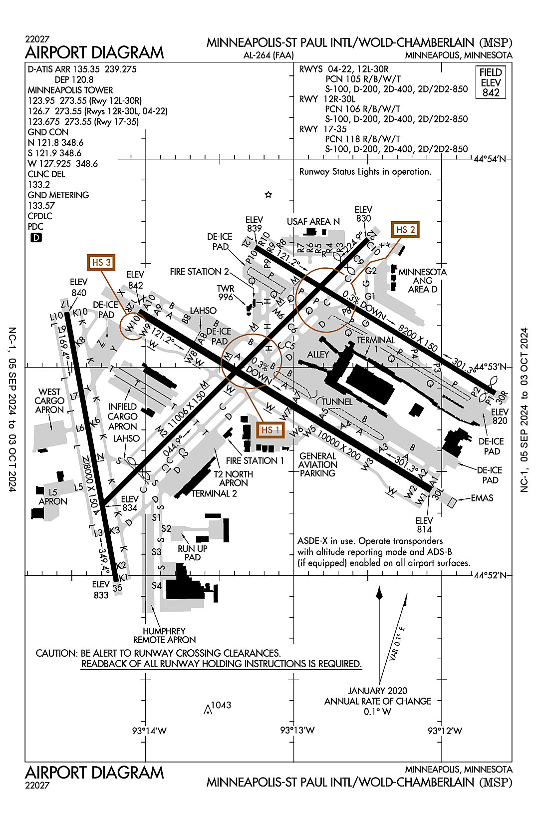
Minneapolis-St. Paul International (Wold-Chamberlain)
ICAO Identifier KMSP
Minneapolis, MN
Minneapolis-St Paul Intl/Wold-Chamberlain
ICAO Identifier KMSP
AD 2.2 Aerodrome Geographical and Administrative Data
2.2.1 Reference Point: 44-52-55.1N / 93-13-18.4W
2.2.2 From City: 6 miles S of MINNEAPOLIS, MN
2.2.3 Elevation: 841.8 ft
2.2.5 Magnetic Variation: 0E (2015)
2.2.6 Airport Contact: BRIAN RYKS
6040 28TH AVE S
MINNEAPOLIS, MN 55450 (612-726-8100)
2.2.7 Traffic: IFR/VFR
AD 2.3 Attendance Schedule
2.3.1 All Months, All Days, All Hours
AD 2.4 Handling Services and Facilities
2.4.1 Cargo Handling Facilities: YES
2.4.2 Fuel Types: 100LL A A++
2.4.5 Hangar Space: YES
2.4.6 Repair Facilities: MAJOR
AD 2.6 Rescue and Firefighting Services
2.6.1 Aerodrome Category: Class-I certified on 5/1/1973
2.6.2 Rescue and Firefighting Services: ARFF Index-E
AD 2.12 Runway Physical Characteristics
2.12.1 Designation: 04
2.12.2 True Bearing: 45
2.12.3 True Dimensions: 11006 ft x 150 ft
2.12.4 PCN: 105 R/B/W/T
2.12.5 Coordinates: 44-52-20.158N / 93-14-17.9427W
2.12.6 Threshold Elevation: 833.5
2.12.6 Touchdown Zone Elevation: 831.7
2.12.1 Designation: 22
2.12.2 True Bearing: 225
2.12.3 True Dimensions: 11006 ft x 150 ft
2.12.4 PCN: 105 R/B/W/T
2.12.5 Coordinates: 44-53-36.9917N / 93-12-29.8434W
2.12.6 Threshold Elevation: 830.3
2.12.6 Touchdown Zone Elevation: 828.3
2.12.1 Designation: 30R
2.12.2 True Bearing: 301
2.12.3 True Dimensions: 8200 ft x 150 ft
2.12.4 PCN: 105 R/B/W/T
2.12.5 Coordinates: 44-52-52.5152N / 93-11-38.296W
2.12.6 Threshold Elevation: 819.5
2.12.6 Touchdown Zone Elevation: 822.4
2.12.1 Designation: 12L
2.12.2 True Bearing: 121
2.12.3 True Dimensions: 8200 ft x 150 ft
2.12.4 PCN: 105 R/B/W/T
2.12.5 Coordinates: 44-53-34.6287N / 93-13-15.5666W
2.12.6 Threshold Elevation: 838.6
2.12.6 Touchdown Zone Elevation: 840.7
2.12.1 Designation: 12R
2.12.2 True Bearing: 121
2.12.3 True Dimensions: 10000 ft x 200 ft
2.12.4 PCN: 106 R/B/W/T
2.12.5 Coordinates: 44-53-16.0438N / 93-14-02.8731W
2.12.6 Threshold Elevation: 841.8
2.12.6 Touchdown Zone Elevation: 841.8
2.12.1 Designation: 30L
2.12.2 True Bearing: 301
2.12.3 True Dimensions: 10000 ft x 200 ft
2.12.4 PCN: 106 R/B/W/T
2.12.5 Coordinates: 44-52-24.68N / 93-12-04.2689W
2.12.6 Threshold Elevation: 814.4
2.12.6 Touchdown Zone Elevation: 823
2.12.1 Designation: 35
2.12.2 True Bearing: 350
2.12.3 True Dimensions: 8000 ft x 150 ft
2.12.4 PCN: 118 R/B/W/T
2.12.5 Coordinates: 44-51-58.2366N / 93-14-11.9205W
2.12.6 Threshold Elevation: 833.3
2.12.6 Touchdown Zone Elevation: 834.4
2.12.1 Designation: 17
2.12.2 True Bearing: 170
2.12.3 True Dimensions: 8000 ft x 150 ft
2.12.4 PCN: 118 R/B/W/T
2.12.5 Coordinates: 44-53-15.9127N / 93-14-32.1137W
2.12.6 Threshold Elevation: 840.4
2.12.6 Touchdown Zone Elevation: 840.4
AD 2.13 Declared Distances
2.13.1 Designation: 04
2.13.2 Take-off Run Available: 11006
2.13.3 Take-off Distance Available: 11006
2.13.4 Accelerate-Stop Distance Available: 11006
2.13.5 Landing Distance Available: 9456
2.13.1 Designation: 22
2.13.2 Take-off Run Available: 11006
2.13.3 Take-off Distance Available: 11006
2.13.4 Accelerate-Stop Distance Available: 11006
2.13.5 Landing Distance Available: 10006
2.13.1 Designation: 30R
2.13.2 Take-off Run Available: 8200
2.13.3 Take-off Distance Available: 8200
2.13.4 Accelerate-Stop Distance Available: 8200
2.13.5 Landing Distance Available: 8000
2.13.1 Designation: 12L
2.13.2 Take-off Run Available: 8200
2.13.3 Take-off Distance Available: 8200
2.13.4 Accelerate-Stop Distance Available: 7620
2.13.5 Landing Distance Available: 7620
2.13.1 Designation: 12R
2.13.2 Take-off Run Available: 10000
2.13.3 Take-off Distance Available: 10000
2.13.4 Accelerate-Stop Distance Available: 10000
2.13.5 Landing Distance Available: 10000
2.13.1 Designation: 30L
2.13.2 Take-off Run Available: 10000
2.13.3 Take-off Distance Available: 10000
2.13.4 Accelerate-Stop Distance Available: 10000
2.13.5 Landing Distance Available: 10000
2.13.1 Designation: 35
2.13.2 Take-off Run Available: 8000
2.13.3 Take-off Distance Available: 8000
2.13.4 Accelerate-Stop Distance Available: 8000
2.13.5 Landing Distance Available: 8000
2.13.1 Designation: 17
2.13.2 Take-off Run Available: 8000
2.13.3 Take-off Distance Available: 8000
2.13.4 Accelerate-Stop Distance Available: 8000
2.13.5 Landing Distance Available: 8000
AD 2.14 Approach and Runway Lighting
2.14.1 Designation: 04
2.14.2 Approach Lighting System: MALSR
2.14.4 Visual Approach Slope Indicator System: P4L
2.14.1 Designation: 22
2.14.2 Approach Lighting System: MALSR
2.14.4 Visual Approach Slope Indicator System: P4L
2.14.1 Designation: 30R
2.14.2 Approach Lighting System: MALSF
2.14.4 Visual Approach Slope Indicator System: P4L
2.14.1 Designation: 12L
2.14.2 Approach Lighting System: ALSF2
2.14.4 Visual Approach Slope Indicator System: P4L
2.14.1 Designation: 12R
2.14.2 Approach Lighting System: ALSF2
2.14.4 Visual Approach Slope Indicator System: P4L
2.14.1 Designation: 30L
2.14.2 Approach Lighting System: ALSF2
2.14.4 Visual Approach Slope Indicator System: P4L
2.14.1 Designation: 35
2.14.2 Approach Lighting System: ALSF2
2.14.4 Visual Approach Slope Indicator System: P4L
2.14.1 Designation: 17
2.14.2 Approach Lighting System:
2.14.4 Visual Approach Slope Indicator System: P4R
AD 2.18 Air Traffic Services Communication Facilities
2.18.1 Service Designation: CD PRE TAXI CLNC
2.18.3 Channel: 133.2
2.18.5 Hours of Operation: 24
2.18.1 Service Designation: D-ATIS (DEP)
2.18.3 Channel: 120.8
2.18.5 Hours of Operation: 24
2.18.1 Service Designation: D-ATIS (ARR)
2.18.3 Channel: 135.35
2.18.5 Hours of Operation: 24
2.18.1 Service Designation: D-ATIS (ARR)
2.18.3 Channel: 239.275
2.18.5 Hours of Operation: 24
2.18.1 Service Designation: EMERG
2.18.3 Channel: 121.5
2.18.5 Hours of Operation:
2.18.1 Service Designation: EMERG
2.18.3 Channel: 243
2.18.5 Hours of Operation:
2.18.1 Service Designation: GND METERING
2.18.3 Channel: 133.575
2.18.5 Hours of Operation: 24
2.18.1 Service Designation: GND/P (N)
2.18.3 Channel: 121.8
2.18.5 Hours of Operation: 24
2.18.1 Service Designation: GND/P (S)
2.18.3 Channel: 121.9
2.18.5 Hours of Operation: 24
2.18.1 Service Designation: GND/P (W)
2.18.3 Channel: 127.925
2.18.5 Hours of Operation: 24
2.18.1 Service Designation: GND/P
2.18.3 Channel: 348.6
2.18.5 Hours of Operation: 24
2.18.1 Service Designation: LCL/P (RWY 17/35)
2.18.3 Channel: 123.675
2.18.5 Hours of Operation: 24
2.18.1 Service Designation: LCL/P (RWY 12L/30R)
2.18.3 Channel: 123.95
2.18.5 Hours of Operation: 24
2.18.1 Service Designation: LCL/P (RWY 04/22, 12R/30L)
2.18.3 Channel: 126.7
2.18.5 Hours of Operation: 24
2.18.1 Service Designation: LCL/P
2.18.3 Channel: 273.55
2.18.5 Hours of Operation: 24
2.18.1 Service Designation: PTD
2.18.3 Channel: 282.675
2.18.5 Hours of Operation:
2.18.1 Service Designation: PTD
2.18.3 Channel: 324.1
2.18.5 Hours of Operation:
AD 2.19 Radio Navigation and Landing Aids
2.19.1 ILS Type: Localizer for runway 04. Magnetic variation: 0E
2.19.2 ILS Identification: APL
2.19.5 Coordinates: 44-53-44.0038N / 93-12-19.9688W
2.19.6 Site Elevation: 832.1 ft
2.19.1 ILS Type: Localizer for runway 22. Magnetic variation: 0E
2.19.2 ILS Identification: SIJ
2.19.5 Coordinates: 44-52-12.792N / 93-14-28.3006W
2.19.6 Site Elevation: 831.4 ft
2.19.1 ILS Type: DME for runway 12L. Magnetic variation: 0E
2.19.2 ILS Identification: PJL
2.19.5 Coordinates: 44-53-03.674N / 93-11-48.8687W
2.19.6 Site Elevation: 824 ft
2.19.1 ILS Type: Glide Slop for runway 12L. Magnetic variation: 0E
2.19.2 ILS Identification: PJL
2.19.5 Coordinates: 44-53-31.1153N / 93-12-56.6941W
2.19.6 Site Elevation: 831 ft
2.19.1 ILS Type: Inner Marker for runway 12L. Magnetic variation: 0E
2.19.2 ILS Identification: PJL
2.19.5 Coordinates: 44-53-39.694N / 93-13-25.8963W
2.19.6 Site Elevation: 845.3 ft
2.19.1 ILS Type: Localizer for runway 12L. Magnetic variation: 0E
2.19.2 ILS Identification: PJL
2.19.5 Coordinates: 44-52-50.3312N / 93-11-33.2418W
2.19.6 Site Elevation: 813 ft
2.19.1 ILS Type: DME for runway 30R. Magnetic variation: 0E
2.19.2 ILS Identification: INN
2.19.5 Coordinates: 44-53-03.674N / 93-11-48.8687W
2.19.6 Site Elevation: 824 ft
2.19.1 ILS Type: Glide Slop for runway 30R. Magnetic variation: 0E
2.19.2 ILS Identification: INN
2.19.5 Coordinates: 44-53-03.4471N / 93-11-48.8472W
2.19.6 Site Elevation: 813.2 ft
2.19.1 ILS Type: Localizer for runway 30R. Magnetic variation: 0E
2.19.2 ILS Identification: INN
2.19.5 Coordinates: 44-53-40.841N / 93-13-29.92W
2.19.6 Site Elevation: 843.1 ft
2.19.1 ILS Type: DME for runway 12R. Magnetic variation: 0E
2.19.2 ILS Identification: HKZ
2.19.5 Coordinates: 44-52-26.9244N / 93-12-20.5476W
2.19.6 Site Elevation: 825.4 ft
2.19.1 ILS Type: Glide Slop for runway 12R. Magnetic variation: 0E
2.19.2 ILS Identification: HKZ
2.19.5 Coordinates: 44-53-07.28N / 93-13-53.62W
2.19.6 Site Elevation: 835.1 ft
2.19.1 ILS Type: Inner Marker for runway 12R. Magnetic variation: 0E
2.19.2 ILS Identification: HKZ
2.19.5 Coordinates: 44-53-20.8698N / 93-14-12.7019W
2.19.6 Site Elevation: 840 ft
2.19.1 ILS Type: Localizer for runway 12R. Magnetic variation: 0E
2.19.2 ILS Identification: HKZ
2.19.5 Coordinates: 44-52-20.3796N / 93-11-54.3455W
2.19.6 Site Elevation: 812.8 ft
2.19.1 ILS Type: DME for runway 30L. Magnetic variation: 0E
2.19.2 ILS Identification: MSP
2.19.5 Coordinates: 44-52-26.9244N / 93-12-20.5476W
2.19.6 Site Elevation: 825.4 ft
2.19.1 ILS Type: Glide Slop for runway 30L. Magnetic variation: 0E
2.19.2 ILS Identification: MSP
2.19.5 Coordinates: 44-52-27.0021N / 93-12-20.2067W
2.19.6 Site Elevation: 812.1 ft
2.19.1 ILS Type: Inner Marker for runway 30L. Magnetic variation: 0E
2.19.2 ILS Identification: MSP
2.19.5 Coordinates: 44-52-19.4377N / 93-11-52.1826W
2.19.6 Site Elevation: 808.1 ft
2.19.1 ILS Type: Localizer for runway 30L. Magnetic variation: 0E
2.19.2 ILS Identification: MSP
2.19.5 Coordinates: 44-53-22.4589N / 93-14-17.688W
2.19.6 Site Elevation: 840 ft
2.19.1 ILS Type: DME for runway 17. Magnetic variation: 0E
2.19.2 ILS Identification: TJZ
2.19.5 Coordinates: 44-53-24.6166N / 93-14-38.0356W
2.19.6 Site Elevation: 832.5 ft
2.19.1 ILS Type: Localizer for runway 17. Magnetic variation: 0E
2.19.2 ILS Identification: TJZ
2.19.5 Coordinates: 44-51-48.4327N / 93-14-09.3727W
2.19.6 Site Elevation: 830.4 ft
2.19.1 ILS Type: DME for runway 35. Magnetic variation: 0E
2.19.2 ILS Identification: BMA
2.19.5 Coordinates: 44-53-24.6166N / 93-14-38.0356W
2.19.6 Site Elevation: 832.5 ft
2.19.1 ILS Type: Glide Slop for runway 35. Magnetic variation: 0E
2.19.2 ILS Identification: BMA
2.19.5 Coordinates: 44-52-07.7086N / 93-14-20.1127W
2.19.6 Site Elevation: 829.9 ft
2.19.1 ILS Type: Inner Marker for runway 35. Magnetic variation: 0E
2.19.2 ILS Identification: BMA
2.19.5 Coordinates: 44-51-49.9075N / 93-14-09.7433W
2.19.6 Site Elevation: 832.6 ft
2.19.1 ILS Type: Localizer for runway 35. Magnetic variation: 0E
2.19.2 ILS Identification: BMA
2.19.5 Coordinates: 44-53-25.7158N / 93-14-34.6512W
2.19.6 Site Elevation: 845.3 ft
2.19.1 Navigation Aid Type VOR/DME. Magnetic variation: 2E
2.19.2 Navigation Aid Identification: MSP
2.19.5 Coordinates: 44-53-47.3958N / 93-14-11.5137W
2.19.6 Site Elevation: 831.6 ft
General Remarks:
NOISE ABATEMENT PROCEDURES - 612-726-9411. NO STAGE 1 CAT CIVIL ACFT. NIGHT HR 2230-0600.
TRNG FLTS PROHIBITED. GA FLTS MUST TRMT AT THE FBO OR US CUSTOMS UNLESS APVD BY AMGR.
MILITARY RSTD: NO HAZ CL/DIV1.1 OR 1.2 EXPLOSIVES PERMITTED. LOADING OR UNLOADING OF HAZ CL/DIV 1.3, 1.4, 1.5 0R 1.6 MUST BE APV BY ARPT DRCT PRIOR TO FLT.
RWY STATUS LGTS IN OPRN.
133 AW AFLD MGMT - 324.1 REMARKS: CALL LIGHTHOUSE.
REMARKS: ALL ACFT MUST CTC NORTHSTAR ON FREQ 252.1 20 MIN PRIOR ARR.
UNSKED ACFT AT TRML 2-HUMPHREY REQ TO CTC TRML 2 GATE CONTROL ON 122.95 OR CALL 612-726-5742 PRIOR TO ARR.
SIGNATURE FLIGHT SUPPORT 128.95
MILITARY: ARFC 934 AW OPS 1300-0400Z++ MON-THUR, 1300-2200Z++ FRI, CLSD WKEND AND FEDERAL HOL. UNIT TRNG ASSEMBLY (UTA) WKEND 1330-2200Z++. ALL TRANS ACFT MUST RECEIVE PPR 48 HR PRIOR TO ETA - CTC AIRFIELD MGMT.
COMMUNICATIONS: MINNEAPOLIS AIR RESERVE STATION JOINT COMD POST - 252.1 REMARKS: CALL NORTHSTAR.
ALL GROUP VI ACFT WITH WINGSPAN GREATER THAN 214 FT PPR REQ PRIOR TO ARR - CTC AIRSIDE OPS 612-726-5111.
934 AW AFLD MGMT - PTD 282.675 REMARKS: CALL VIKING OPS.
BIRDS ON & INVOF ARPT.
ALL GROUP IV AND LRGR ACFT OPRG ON THE PTN OF TWY S ADJ TO DELTA BLDG C RQR THE USE OF WINGWALKERS AND THAT THE VEHICLE SVC ROAD BE CLEAR OF VEHICLES.
ALL GA ACFT WITH LESS THAN 20 PAX THAT NEED TO CLEAR US CUSTOMS SHOULD CTC SIGNATURE FLT SUPPORT 128.95 OR 612-726-5700 PRIOR TO ARR.